Travel: From Silverton, in a 4WD vehicle with high clearance, drive north on US 550 toward Ouray for 2.0 miles. At the sign for the South Mineral Campground turn west onto San Juan CR 7 (FSR 585). Turn north on Clear Lake Road, FSR 815, 3.7 miles from US 550. The rocky surface is steep with hairpins; 4WD low is helpful. The track becomes a mild shelf as it approaches Clear Lake. The road is popular with the four-wheeling crowd recreating at the lake. Park 7.9 miles from the highway in a three-vehicle pullout. This is just as you enter the upper basin and before the road heads down to the lake shore. Clear Creek is to the west and an old roadbed to the east.
Distance and Elevation Gain: 6.0 miles; 2,550 feet of climbing for both mountains.
Total Time: 4:00 to 5:30
Difficulty: Mining track, mostly off-trail; navigation moderate; steep slopes; low Class 3 with some exposure on the south wall of V5's summit ridge.
Maps: Ophir; Silverton, Colorado 7.5' USGS Quads or Apogee Mapping
Date Hiked: July 26, 2018
Quote: So, simply to look on anything, such as a mountain, with the love that penetrates to its essence, is to widen the domain of being in the vastness of non-being. Man has no other reason for his existence.
Nan Shepherd, The Living Mountain
When seen from the north rim of Paradise Basin, V5 is both powerful and majestic. The conical shape, color, and rock uniformity of V6 (image-left) makes the distinctive mountain easy to identify from US 550 and summits in the locale. (Thomas Holt Ward, photo)

Route: An abandoned mining road accesses the couloir that penetrates the V5 summit ridge. Walk northwest to the crest. You may bypass the V5 couloir by taking the blue-line route and upclimbing the South Wall. Traverse to V6 by downclimbing the South Wall on its west face. Use a game trail to bypass the obstacles on the east ridge of Point 12,988'. Walk east on the ridge and climb the V6 summit cone. On the return, link back up with the south end of the wagon road at a prominent mine identified on the map. Do an out-and-back on the return route if you wish to climb V6 only.

From the parking pullout, elevation 11,860 feet, cross the Clear Lake Road and start up the mining track. It initially presents as a trail but soon widens. Dodge talus blocks that have sloughed from the slopes above. This shot of the parking area was taken at the end of the hike.

A wall of San Juan explosive volcanics rims the road on the east. This garbage rock is pretty to look at but increases the challenge for climbers. (THW, photo)

Wildflowers take over the roadbed and the sun powers over the climbing ridge. (THW, photo)

V5 Couloir Route
At 0.8 mile, 12,460 feet, leave the road and climb the steep hillside. Aim for the block field in the center of the image below.

The couloir bifurcates. Head into the north/left branch. Notice the two distinctive blocks image-center. Climb to their base and then head into the gap on the right.

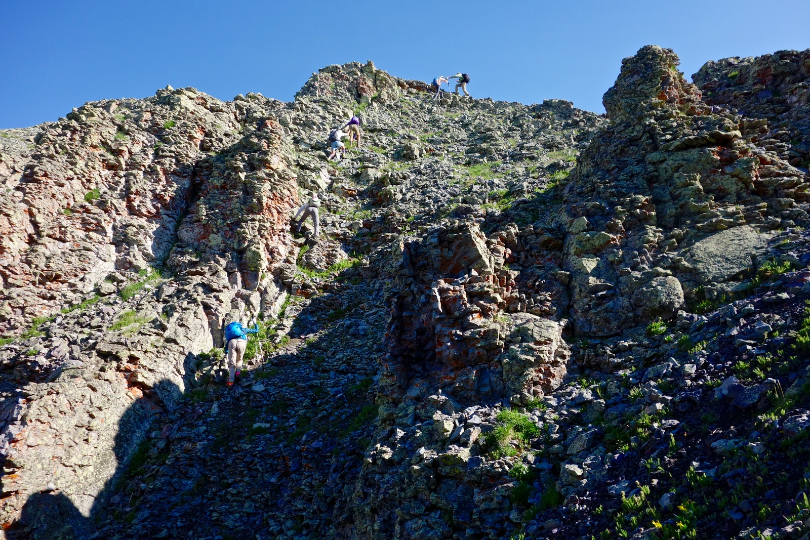
The couloir is steep, the rocks are loose, the holds undependable. We had a sizable group which increased the hazard in spite of everyone's considerable climbing experience. (THW, photo)

These climbers are going right of the blocks described above. It appears that they are at the top but more climbing awaits. (THW, photo)

Our group split up; some went for the northern route, shown. I climbed in the throat of the couloir which worked beautifully.
The gully terminates on the ridgeline at 13,060 feet, no more than five minutes from the summit. (THW, photo)

Crest the impressive little peak at 1.1 miles after just 1,300 feet of climbing. For reference, it took our group of ten one hour to summit. You may be more efficient by going directly up-slope rather than hiking on the road's sweeping switchbacks. The peak register dates to 2007. Even though the sky was hazy from several regional fires, in the east we could see Wetterhorn Peak, Uncompahgre Peak, and Half Peak. Mountains encircle Clear Lake, a colorful blend of emeralds and sapphires. Starting from the left in the photo below the peaks at skyline are: Grizzly Peak, Fuller Peak, Vermilion Peak, Golden Horn, Pilot Knob, V2, V4, US Grant, V3, three unnamed 13ers above Clear Lake, South Lookout Peak, Palmyra Peak, and Peak 12,935' in Paradise Basin. (THW, photo)
V5 and South Lookout Peak are occasionally climbed as a pair by traversing the ridge between them. The north face of V5 is vertical and must be bypassed on the west. I have been on the ridge and it is troubled and tedious. I believe it would be faster to return to Clear Lake and initiate the South Lookout climb from there. All of the various approaches, including from Paradise Basin, utilize east face gullies. In the image below, the mountain to the right of South Lookout is a grassy, pleasant ascent. Explore Paradise Basin by climbing Peak 12,935' and traversing to Point 12,860' to overlook Crystal Lake.

South to Point 12,988'
In the image below hikers are walking south from V5; the first has just past the couloir notch. (THW, photo)

At the top of the next rise arrive at the South Wall of the summit ridge. The low Class 3 downclimb is located on the west face. Test all holds; the route is somewhat exposed. I am standing a fair distance down the wall. Two friends have dropped about 100 feet to the base. (THW, photo)

Finish by scrambling down this crack.

The South Wall marks the definitive end of the V5 summit ridge.

Alternative blue-line route up V5: South Wall of Summit Ridge
I enjoyed our route because it incorporated the best of two divergent worlds--a couloir and a wall. If you prefer to avoid the couloir, climb V5 thusly. At 0.9+ mile from the parking pullout, elevation 12,520 feet, there is a large cairn on the mining track. This is the first opportunity to climb a grassy slope to the ridge, shown. The further south you go on the road the easier the climb but the further you are from V5. The ridge is gorgeous, smooth walking so take your pick.

South of the summit wall it is a friendly stroll across the tundra to Point 12,988', shown. Enroute, look carefully and you will see an unreal brilliant blue dot--Ice Lake.

Crest Point 12,988' at 1.7 miles. This prominence marks the southern end of the ridge emanating from South Lookout Peak. The spine swings east and tracks well above the South Fork of Mineral Creek. We hoped to stay on the eastward ridge but the upper section is cluttered with gendarmes and bad rock. Below, hikers stand on the turning point; V5 is off to the right. (THW, photo)

East to V6, Peak 12,442'
Descend 200 feet south down a rubbly slope. Three trails trampled in by elk head east on the southern slope of Point 12,988'. We took the highest trail over but they all work beautifully.

The game trails track below the ridge obstacles. This superb route was an unexpected gift from the animals.

The three trails merge and lead onto the ridge at 12,300 feet. The divide is broad and beautiful, the walking unobstructed, flat, and easy.

Drop into the saddle at 2.8 miles, 11,980 feet. I followed an elk track most of the way up the summit cone, shown. This is a friendly mountain with manageable steepness. The fire-colored scree is remarkably uniform and stable. Deep rooted spring beauty burrow into the mountainside. (THW, photo)

Crest the softly rounded summit at 3.1 miles. The space is big and welcoming but this 12er doesn't see many humans. Mike Garrett placed the peak register in 2008; it lists only one visitor in 2016 and 2017. The red symmetrical mountain is easily recognizable from US 550, Anvil Mountain, and the local surrounds. Two ridges drop eastward into Mineral Creek. The elk appear to transfer between watersheds by charging over the top of V6. (THW, photo)

On the return you are looking at the imposing east face of the traverse from V5 to Point 12,988'.

We nailed the route back. We took the lowest of the three elk trails, shown, gaining the southeast ridge of Point 12,988' at 12,400 feet.

The game trail continues west to crest the south ridge at 12,700 feet. From there, we walked northwest while losing some elevation. At 12,560 feet, 4.8 miles, we were at the mine where the abandoned road terminates. We simply stayed on the track all the way back to Clear Lake.

Between the flowers and the view this access road was actually quite beautiful. A Snow Apollo butterfly was alight upon an old man of the mountain. (THW, photo)

Mountains shed into Clear Lake and the great receiver throws off light and color to astound the few that walk along the old wagon road. (THW, photo)

No comments:
Post a Comment