Travel: From Main Avenue in Durango, go west on 25th Street. It transitions to Junction Street and then La Plata CR 204. At the first stop sign, 2.8 miles from Main Avenue, turn right onto CR 205 and pass Turtle Lake. South Meadow parking is 2.3 miles out CR 205 beside big boulders; Mid-Meadow parking is at 3.1 miles. You may also access Hidden Valley on foot or bike via the old Falls Creek Road. From the intersection of US 550 and CR 203, drive 2.3 miles north to limited parking on both sides of the two lane in the 3900 block.
Hidden Valley Acquisition: In 1990, Pacific Corporation, a utility company based in Salt Lake City, decided to sell the 530 acre parcel for development. La Plata Open Space Conservancy spearheaded a grass-roots movement to compel Congress to appropriate $800,000 of the 1.1 million needed to acquire and protect Hidden Valley. On March 30, 1992, the land became public property managed by the Forest Service.
Distance and Elevation Gain: Build your own hike. Walk a segment or the full tour, 7.8 miles with 1,100 feet of climbing. If you access Hidden Valley from CR 203, it will add 480 feet of vertical.
Total Time: 3:00 to 5:00 for the full loop
Difficulty: Trail; navigation easy; mild exposure on the ridge near Peak 7,385'
Map: Durango East, Colorado 7.5' USGS Quad or Apogee Mapping
Quote: The person with a clear heart and open mind can experience the wilderness anywhere on earth. The planet is a wild place and always will be. Gary Snyder
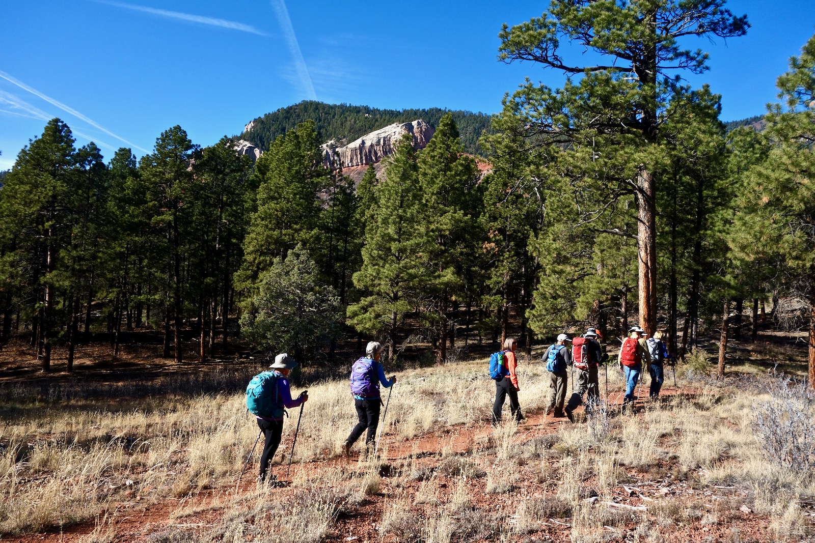
The complete loop traverses the length of the open meadow in the center of this image and the Entrada Sandstone ridge separating Hidden Valley from the Animas River Valley, as seen from Animas City Mountain.

Route: The suggested hike begins at the south end of the Forest Service property and goes north to the Mid-Meadow Lateral Trail. Turn east, gain the ridge, and walk south to Peak 7,385'. Turn around and head north to the Valley Fire Overview. Hike south on trails that favor the west side of Hidden Valley.

South Meadow to Mid-Meadow Lateral Trail (0.8 mile)
Park adjacent to large boulders that have exfoliated from the cliff-ringed escarpment west of the road. An informative placard explains that the 1,500 acre Falls Creek Archaeological Area adjoins Hidden Valley on the west side of CR 205. The Durango Rock Shelters were occupied by the Basketmaker culture almost continuously from 200-900 AD. The site was abandoned until the arrival of the modern Utes. In the 1930's, archaeologists discovered a number of mummified bodies in a burial crevice, Esther's Cave. Importantly, the site documents the transition from nomadic hunter-gathers to stationary farmers. This area is closed to all public entry.

From the trailhead, elevation 7,000 feet, notice the sandstone ridge confining the valley on the east. Peak 7,385' is image-right.

Walk north, up valley. Two trails parallel each other, take your pick. There is a sense of peaceful protection in this hanging valley sheltered by the eastern escarpment of the Barnes Mountain cuesta. This is important wildlife habitat; the Falls Creek drainage is a migration corridor for deer and elk from the high country to winter foraging grounds in the Animas River Valley.

Entrada Sandstone Ridge to Peak 7,385' (2.2 miles roundtrip)
Both northbound trails intersect the Mid-Meadow Lateral Trail which begins at a second parking area along CR 205. Turn right and gain the ridge at the low point between two rollers. Old growth ponderosa favor this location. In summer Mariposa lily and scarlet penstemon enliven the ground.

Turn south on the trail running up the ridge. Mount a pretty darn steep little hill, the toughest grade on the entire hike. While walking through the piñon-juniper and Gambel oak woodland be watchful for mountain lions, bear, and golden eagles.
Just as the second roller begins to soften take a few strides to the right (1.6 miles, 7,360 feet) and step onto sandstone. Welcome to one of Durango's most unexpected and magical places. Solid rock, soft forms, pure delight.

Scampering is irresistible. Some people can handle the friction pitches on the ridgecrest but most will need to back up and return to the southbound trail on the east side of the outcrop.

Do a short Class 2+ scramble. The ridge narrows briefly so be steady.

Continue out the stone ridgetop to Peak 7,385', shown. This little crest is a wonderful lookout over home territory. Swing around and take in Animas City Mountain, the Turtle Lake community, San Juan Mountains, and Missionary Ridge constraining the Animas River. The peak is very near the southern boundary of public land so this is our turn-around.

The prominent cliff formation you see as you look across Hidden Valley is light gray Entrada Sandstone. If you are wondering whether you took an unexpected portal to Utah, consider that the windows in Arches National Park were carved from a salmon-colored variety of Entrada Sandstone. Junction Creek Sandstone is the thinner band above. The Entrada overlies Dolores Formation red-beds (in the Chinle Group). Heading north we'll be walking on quartzose sandstones, grits, and conglomerates characteristic of the Dolores Formation.

Retrace your steps. Depending on how much slickrock romping you do, you'll be back at the Mid-Meadow Lateral Trail at about 3.0 miles.

North to Falls Creek Crossing (0.9 mile)
Upon reaching the Mid-Meadow Lateral Trail, continue north for the full tour. Social paths spin off; stay on the ridge trail. Clumps of claret cup cactus thrive. In early summer they will morph into showy red blossom blotches. Gently climb to Point 7,232' and look out over cottonwood stands curving along Animas River oxbows.

The two-tiered ramparts to the west have enchanted and protected humans for millennia.

Enter a forest and descend steeply to Falls Creek. At the cottonwood grove, shown, the trail splits at a Y. Take the right branch and cross Falls Creek on the lower of two bridges at 3.9 miles. In a few feet the trail splits again; go right and ascend about 100 feet out of the drainage to a four-way junction. A hard left takes you to the north end of the meadow; a hard right descends to CR 203. Take the soft right.

Aside: East Portal to Hidden Valley (0.8 mile)
A popular trail ascends from CR 203 to the preserve. Falls Creek Road was established as a public roadway in 1979 linking the Animas River Valley with Hidden Valley. For some years a dispute with the adjacent land owner put public access into question. The conflict was resolved in 2018. It is posted private property on both sides of the old roadbed. Please stay on the trail for the first half mile west of CR 203.
The trailhead, shown, is at elevation 6,600 feet. The road has narrowed and is effectively a single track hemmed in by enthusiastic rabbitbrush. The trail does a mellow rising traverse north-northwest. An open gate indicates passage onto public lands.

Fifty yards upstream of the boundary is a small cascade on Falls Creek. A ten-foot-tall cylinder of ice with water trickling inside will form after a sustained winter cold spell.

Church Camp Trail to Valley Fire Overview (1.0 mile).
The trail leaving the four-way bears east for a short distance before curving north. The smooth dirt path transports the hiker through a color wheel of red earth, green trees, and blue sky.
In relying on various local comments, the Church Camp Trail was named as an "old road that went to a summer camp on the hillside west of CR 203." There is an existing summer camp, the Whispering Pines Bible Camp, or "Church Camp", owned by First Baptist Church. It is accessed via a historic road off CR 203, but this road is different than the Church Camp Trail.
At 4.8 miles, the Church Camp Trail branches right at two small red boulders. In 0.4 mile, it is posted private property and you will have to turn around. This hike continues up the track passing a green metal box.

The northern terminus of the hike is very near the Forest Service boundary. At 4.9 miles step off the trail at the Valley Fire Overview. On June 9, 2002, the Missionary Ridge Fire ignited and burned for 39 days. During this inferno, on June 25, 2002, an electric-fence charger started a grass fire just west of CR 203. The Valley Fire burned 439 acres and destroyed ten houses. The view corridor is now wide open to Hermosa and beyond to the San Juan Mountains.

Return to the South Meadow Trailhead (2.9 miles)
Continue on the trail just a few steps west to the crest of a soft ridge and turn south. A cairn typically marks this subtle junction. The path flanks the east side of a small rise and then descends on an old roadbed to Turner Lake at 5.5 miles. The land to the immediate west, including the lake, is Falls Creek Ranch private property so stay on the trail.

Climb one last roller before descending back to the valley floor on a stony path. The shining needles of these ponderosa have a charmed capacity to reflect light. At the bottom of the hill a trail forks left. Take this branch if you wish to return to CR 203. Otherwise, stay straight. Cross Falls Creek once again on planks.

The trail tracks the west side of the meadow to avoid the wetlands and riparian habitat in its center. Grasses are lush and diverse. Hug or climb The Cube.

At 6.8 miles you will be back at the Mid-Meadow Lateral Trail. Do a jog to the left and then continue south on either of the east-side parallel trails (presumably the one you have not yet walked upon). This image looks north from the center of Hidden Valley.

On a Sunday afternoon in autumn, locals mix it up: bikes, dogs, walkers--it's a happening scene in Hidden Valley.

No comments:
Post a Comment