Travel: Mile markers on U.S. 50 start counting up from the Nevada-Utah border. The highway curves around the south end of the House Range. In a 4WD vehicle with good clearance, from Delta turn right onto a graded gravel road just past mile marker 48 (47.9). Measure from here. In one mile bear right, merging onto Old Hwy 6. Turn left at the sign for Miller Canyon at 3.4 miles. Enter the Notch Peak Wilderness Study Area near a pavilion and pit toilet. At the sign for Sawtooth Canyon and Notch Peak Trailhead, turn left at 8.6 miles. The next 3.3 miles are rough and rocky. Pass a corral and then a mortarless stone block cabin. Park at 11.9 miles just past the trailhead for Hell'n Moriah slot canyon. For those traveling from the west you may turn north onto Old Hwy 6 at mile marker 46. Stay straight at spurs. At 1.9 miles, the road for travelers coming from the east merges on the right. No facilities and no water.
Distance and Elevation Gain: 8.2 miles; 2,900 feet of climbing (includes Point 9,340')
Total Time: 4:30 to 6:00
Difficulty: Trail; navigation easy; Class 2+; cliff exposure can be avoided; bring all the water you will need. Hike in the spring or autumn. The canyon holds snow into spring. We were there at the end of the season with temperatures in the 90s.
Maps: Notch Peak; Miller Cove, UT 7.5' USGS Quads
Date Hiked: June 5, 2020
Quote: A lone peak of high point is a natural focal point in the landscape, something by which both travelers and locals orient themselves. In the continuum of landscape, mountains are discontinuity – culminating in high points, natural barriers, unearthly earth. Rebecca Solnit
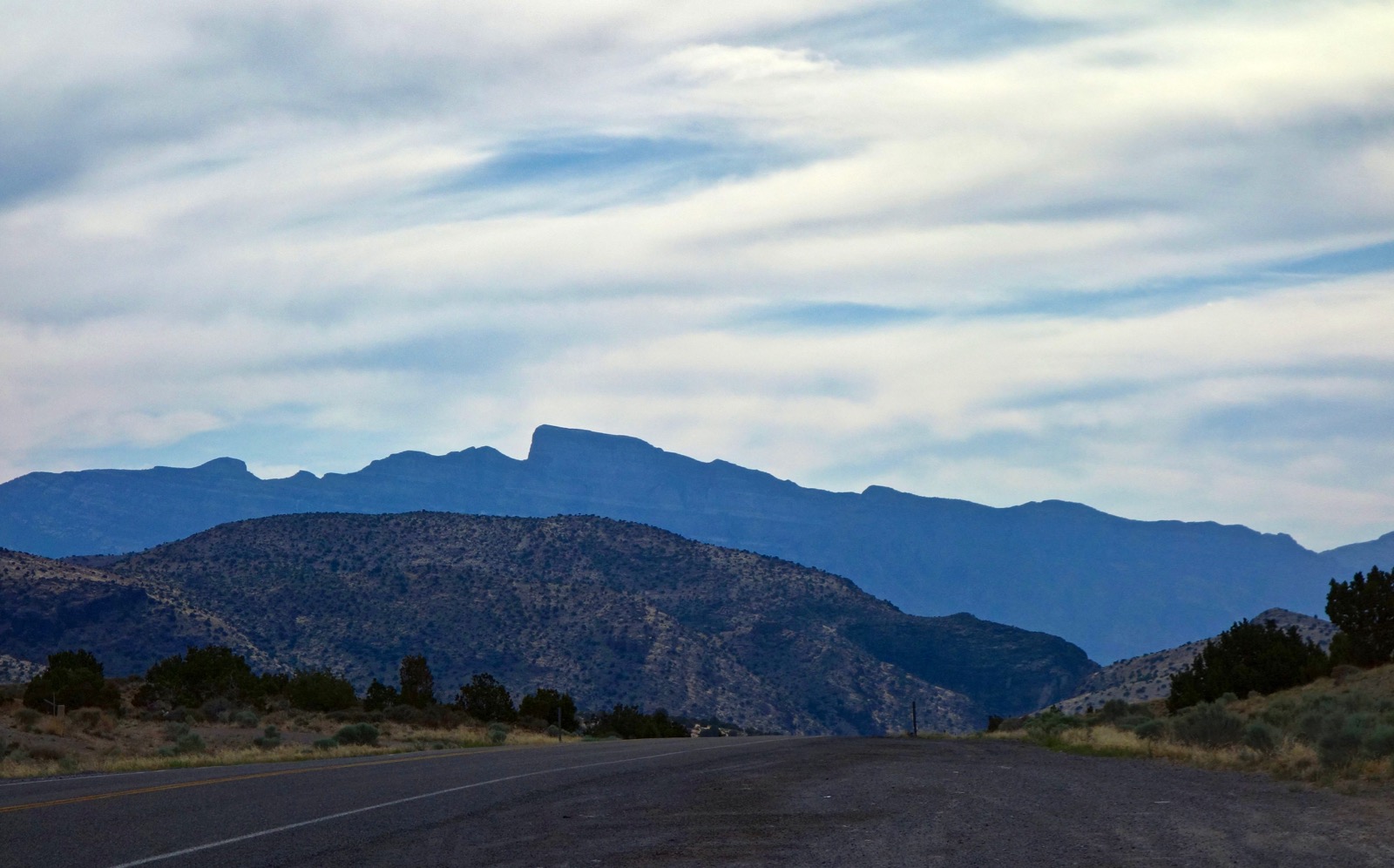
The distinctive Notch Peak profile is visible along Highway 50 from Great Basin National Park to the outskirts of Delta. The unbroken perpendicular amphitheater that forms the notch borders on the unfathomable.
(Thomas Holt Ward, photo)
Route: Walk northwest up Sawtooth Canyon and then west through an unnamed tributary. Leave the narrow canyon and ascend north on the south ridge of Point 9,340' to the saddle at 9,260 feet. Climb the east ridge of Notch Peak. Return to the saddle and ascend east to Point 9,340'. Retrace your steps.

From the Notch Peak Trailhead, 6,860 feet, walk northwest up the Sawtooth Canyon two-track on a bed of soft gravel. The WSA is open to hikers and equestrians only. Limestone is terraced on the right and forms a wall punctured with caves on the left. (THW, photo)

Rise gently through heavily scented big sage, rabbitbrush, ephedra, and piñon-juniper. Below, the access canyon approaches on the left.

Mid-day when the rocks were sizzling we saw two Great Basin collared lizards with distinctive orange rings. We did not see rattlesnakes but they are in this area so be watchful. (THW, photo)

At 0.7 mile, 7,100 feet, the trail makes a 90 degree left into an unnamed canyon heading west. The footpath stays in the canyon bottom for 2.5 miles. The stone walls on either side close in and pull back in a wave pattern. Moisture and shade-loving plants grow from cracks in the walls. Foliage is thick but never an annoyance. (THW, photo)

A variety of tall trees provide shade. Most common are elder piñon and juniper. If you know the name of the conifer in the photo below please leave a comment. (THW, photo)

At 1.5 miles look up to see a skyline arch on the north wall. (THW, photo)

The trail is friendly and detectable. There are limestone staircases and sidewalks. At 2.9 miles, 8,300 feet, you will encounter this fallen giant with a spiral trunk and colorful wooden tower. Climb the Class 2+ pitch.

At the top of the short climb is a pounded trail heading out of the canyon on the right, shown. We mistakenly took that loose end, clearly a point of confusion for many. The route got very steep with loose rock working up through layers of limestone. After 100 feet of climbing we could see the perfectly good trail in the canyon bottom and worked our way back down.

Above the canyon we passed by this wall that looks like a layer cake with oozing frosting. (THW, photo)

The proper route remains on the canyon floor. Immediately after the initial scramble, you will encounter a second Class 2+ pitch.

The next canyon segment is exceptionally beautiful. Sloping walls come down to meet the bedrock passage. Look in limestone crevices for House Range Primrose. It grows between 8,500 and 9,000 feet and only in the House Range. It blooms with purple flowers in May and June.

At 8,720 feet the canyon splits. A row of barrier rocks directs you into the left branch. Climb more natural staircases and break out of the canyon at about 8,800 feet. Climb north-northwest on the east side of the rounded south ridge of Point 9,340', shown. The path is clear for awhile but then it braids.

Work your way to the center of the ridge, shown, and then find your way to the saddle.

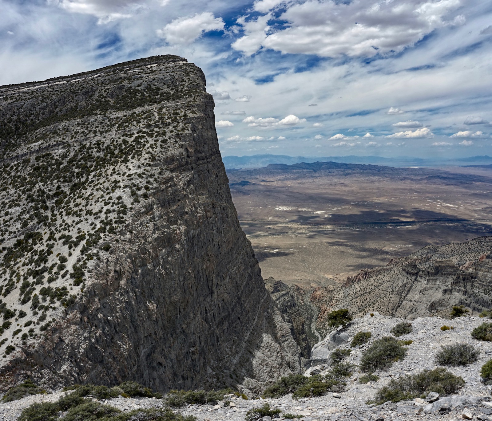
Upon reaching the saddle at 3.7 miles, 9,260 feet, you will be standing in the center of the notch. Welcome to a uniformly gray vertiginous world. Two thousand feet straight down is startling and impossible to grasp, both terrifying and thrilling. We would like to return to walk the rim of the amphitheater over to Point 9,424', shown. (THW, photo)

There are braided trails up the steep east ridge to the summit, 0.3 mile off. It was a windy day and there was loose material on the path so we stayed well away from the crumbly edge.

There are good footholds in the inclined bedrock. Watch for spectacular stromatolites in the Cambrian carbonate Notch Peak Dolomite.

The crest rounds off as you top out. Flat and horizontal Sevier Lake to the southeast is a study in contrast. (THW, photo)

The summit is as edgy as you'd expect but it is also roomy with a flat surface for comfortable surveying. Aerial swifts were dive bombing around our heads. The peak cairn built by the Wasatch Mountain Club has a cavity for the summit register. Judging from all the notebooks, Notch Peak has a devoted following.
Looking at the image below, to my left is the Confusion Range. The tallest mountain in the distance is Wheeler Peak in the Snake Range within Great Basin National Park. At elevation 13,065 feet, it is the second-highest peak in Nevada, 81 feet shorter than Boundary Peak. (THW, photo)

The Notch Peak Benchmark was placed in 1957. (THW, photo)

The only (relatively) safe way to look straight down is to lay on your belly. Check the integrity of the edge first.

At 2,200 feet, this is the second highest continuous vertical rock face in America behind El Capitan (3,000 feet). Mountain Project details four classic climbing routes from Notch Peak Canyon up the north face of the "limestone monster." The twelve pitch traditional climb is rated 5.10 to 5.12 with serious rockfall danger.
The summit rises 5,200 feet above the depression in Tule Valley. It is considered one of the best wingsuit BASE jumps in America. While a small group of wingsuiters return time and again to make the jump, there have been a series of tragic fatalities over the years. (THW, photo)

Climb the little prominence east of the saddle for the finest view of the north wall. Round trip to Point 9,340' is 0.2 mile with less than 100 feet of climbing. There are 3,000 to 4,000 year old bristlecone pines surrounding the knob.

From Point 9,340' the lookout is incomparable. See the span of upthrust from Notch Peak Canyon to the summit.
(THW, photo)

I'd like to conclude with a few images taken from the road. This photo was shot from Miller Canyon. The hiker's east ridge faces the camera. Point 9,340' is tucked below the north wall, barely visible. Point 9,424' is right of the saddle.

This image was shot in the afternoon from Tule Valley just off U.S. 50 looking at the west side of the peak. (THW, photo)

Personal note: I've been fascinated with Notch Peak since childhood when my family drove from California to Colorado annually on The Loneliest Road in America. I always figured the peak was off limits to all but technical climbers. I found the east-side trail with a little internet research and we climbed that dream on our very next trip out west.
No comments:
Post a Comment