Essence: Hike to the distinctive slim peak that tempts from Forest Hill. It is ironic that North Star Peak lies in the shadow of Forest Hill, 6,114', the highpoint in the Little Rincon Mountains. North Star is rarely visited. The companion mountains have remarkably similar weathered stone formations composed of crystalline, pegmatite-infused granite. The option to add unranked, radical Point 5,615', increases the challenge. This is classic and rugged Sonoran ridge walking, off-trail and cairn-free. Expect significant boulder hopping, steep slopes, and expansive vistas. North Star Peak is in the Coronado National Forest. Point 5,615' is on Arizona State Trust Land.
Travel: From I-10, take Exit 297, Mescal Road. Measure distance from the stop sign at the end of the eastbound off-ramp. Drive north on Mescal Road, a paved two lane with a view of the Little Rincon Mountains and North Star Peak. Pavement ends 3.2 miles from the interstate. Transition to FSR 35 at 4.3 miles. It is a graded and wide road bed prone to washboard. Wind up Ash Creek which drains the Little Rincons on the east and the Rincon Mountains to the west. Pass Ash Creek Ranch at 7.2 miles. Ford Ash Creek two times. The first and deepest crossing at 8.1 miles may require 4WD with high clearance. Pass through private Mackenzie Ranch, cross a cattle guard (reentering Coronado National Forest) and then turn right into a large parking and camping area, 9.1 miles from I-10.
Distance and Elevation Gain: 7.0 miles; 2,850 feet of climbing. Point 5,615' adds 1.5 miles and 150 feet of vertical
Total Time: 5:30 to 7:00 for North Star. Add about 1:30 for Point 5,615'
Difficulty: Off-trail; navigation moderately challenging; Class 2+ bouldering and scrambling; mild exposure; dress defensively; carry all the water you will need and hike in cool months.
Map: Galleta Flat West, Arizona 7.5' USGS Quad
Date Hiked: February 5, 2021
Quote: If I could put my hand on the North Star, would it be as beautiful? Ralph Waldo Emerson
The allure of North Star Peak cannot be denied. Trip reports suggest following the route to Forest Hill and then climbing the prominent westward draw seen below. However, we were enchanted by the idea of a ridge walk and that strategy worked beautifully. This image was captured from a vantage point below the summit of Forest Hill.
(Thomas Holt Ward, photo)

Route: The basic instruction is simple: gain a southwest-running ridge and walk northeast all the way to the peak. When you get out on the land, the way is not so obvious. Three ridges coalesce at Point 5,852'. From there, climb the subsidiary peak, Point 6,020', drop into a saddle and pitch up to the summit of North Star. The blue-line route depicts the optional trek to Point 5,615'. Our return course avoids private property. Do your homework before hiking if you intend to divert from this path. CalTopo has a Public Lands button that we find indispensable.

From the parking area, elevation 3,940 feet, walk northeast and locate an opening in a fence at the base of the west slope of Point 4,304'. Walk north in the wash, or alongside on cattle paths. In a third of a mile, begin watching for an appealing place to leave the wash and ascend east on a gradual slope to gain the ridge. You will be in the vicinity of the saddle north of Point 4304' at about 4,220 feet in just over half a mile.
Ascend northeast through the vegetative zone, Apache Highlands Grassland. There are robust barrel cactuses, pricklypear, cholla, ocotillo, mammillaria, and shrubs with razor sharp thorns. Shindaggers are a hazard throughout the hike--wear long pants.
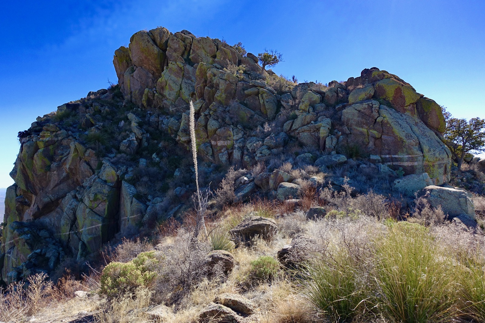
As you move up the ridgeline the boulders get bigger and rock hopping ensues. Most of the exposed stone is composed of coarse-grained intrusive granite. The rock is prone to weathering in compelling spheroidal shapes and sheds large quartz nuggets. Encounter the only obstacle that must be threaded at 0.7 mile. The dome has been informally named the Stone Temple. Madrone trees are sheltered in the crevices. We started out on the east side and then moved west, walking between the reefs, pictured. Pick your own route throughout this fluid ridge hike. (THW, photo)

Once past the dome, climb back onto the reef. This has been a dreadfully parched winter in Southern Arizona. It rained a week prior to our hike and resurrection plant (spikemoss) interspersed on bedrock sheets had greened up.
(THW, photo)

Ascend steeply to the top of the first significant knob at 1.1 miles, 4,580 feet. The ridge is part of a wide-ranging grazing allotment. It is covered in cow pies and the grasses have been chomped. The stock have not wandered higher than about 4,900 feet. The ridge appears to divide but it's just a ridgelet joining from the west. Stay to the right and top out on a roller at 1.7 miles, 5,140 feet, shown. Drop about 50 feet and resume climbing. (THW, photo)

Our ascent ridge roughly parallels a severely crenelated ridge to the west, image-center, and the north ridge of Point 5,615' on the east, off-camera. (THW, photo)
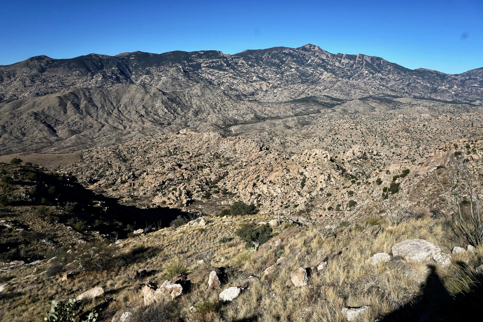
The three ridges join together at Point 5,852', our next goal, image-left.

A few elder Arizona oak live among great slabs of rock in the basin headed by Point 5,852', image-right. We first went to the saddle west of Point 5,852' but you could climb the prominence directly, or even flank it on the east as we did on our return.

If you hold the contour on the east side at 5,720 feet, you will pass by an astonishing quartz outcrop.

Those who climb Point 5,852', 2.7 miles, will be rewarded with a view of Forest Hill and a unique angle on Mount Wrightson in the Santa Rita Mountains. (THW, photo)

A barbed wire fence north of Point 5,852' was crafted by a highly skilled cowboy. Rincon Peak, 8,482', is almost 2,400 feet taller than the highest summit in the Little Rincons.

Give up 150 feet and then continue ascending through boulder clusters. Point 6,020' is the softly rounded knob seen below on the ridgetop.

Finally, North Star Peak and its intimidating west ridge come into view. (THW, photo)

The downclimb from Point 6,020' to the saddle at 5,900 feet is abrupt but the footing is good. On the ultra steep, final climb to North Star Peak, be methodical and pick your course carefully to avoid rolling rocks.

The needle-like zenith falls off into oblivion on three sides with a rise of 1,021 feet. Top out at 3.5 miles after 2,470 accumulated feet of vertical. (Remarkably, this is just ten feet shy of the elevation gain to Forest Hill.) Sure, the Rincon Mountains are a good deal mightier but the Little Rincons hold their own for granitic beauty and charm. (THW, photo)

Forest Hill rises up from Hidden Pasture to the northeast. Mica Mountain, 8,664', is the highest point in Saguaro National Park and the Rincon Mountains. Among the series of eastward sky islands visible are the Winchester, Galiuro, Pinaleño, and Dragoon mountains.

There are good sitting rocks for perusing the summit register. The Angeles Chapter of the Desert Peaks Section of the Sierra Club placed the register in November, 1996. On average, one party a year signs in. The Southern Arizona Hiking Club visited in 2019. They posted the one trip report we found prior to our hike. They took the standard route toward Forest Hill and then pitched roughly 1,000 feet in half a mile through brushy terrain up the west-facing gully, pictured, to the saddle south of North Star. (THW, photo)

Optional Trek to Point 5,615'
Most hikers will choose to retrace their steps to the parking area. The image below shows the climb back to Point 6,020' and the north ridge running out to Point 5,615'. With a rise of 275 feet, it doesn't make the 300-foot requirement to be a legal summit. However, it is an ultra fun and appealing prominence. The route is depicted on the map provided with a blue line.

It is 1.3 miles from the vicinity of Point 5,852' to the prominence. The stretch is of comparable difficulty to the hike thus far although boulders are more concentrated. At first, they are flat-topped and you can jump from one to the next.

Drop into the first and higher saddle at 5,420 feet. The ridge grows in difficulty and progress slows. Bypass the serious gendarme beyond the saddle on the west and return to the spine. (THW, photo)

Descend through a boulder field to the low saddle at 5,340 feet. Ascend through a park on the west side of the ridge, so quiet and peaceful, with gorgeous golden grasses, sotol, rainbow mammillaria, and mature ocotillo. Then scale up through a pile of spheroids to the base of the summit block. We found a Class 2+ climb to the crest on the west side. It was a short but steep pitch through grass and boulders, free of exposure.
Point 5,615' might not be a ranked summit but it sure feels like one. We topped out on the stack of massive, rounded off boulders at 5.8 miles. Below, I am standing on the highest of all the boulders, happily taking in the stunning view of North Star Peak. We were just there! (THW, photo)

Look east across the purple-hued San Pedro River playa to Apache Peak in the Whetstone Mountains, plus the Dos Cabezas and Chiricahua mountains. (THW, photo)

The image below shows ranches on Ash Creek and our return ridge. It rough parallels the ascent ridge but at a substantially lower elevation. Take note of the Stone Temple southwest of Point 4,862'. To begin, retrace your steps on the north ridge to about 5,360 feet. Segue onto a broad ridge bearing west and then southwest. The terrain is similar to previous ridges traversed.

Reenter cattle territory, cow pies everywhere, the grasses mowed. Ascend to Point 4,862' and pause to take in the surrounding massive basin. Descend to about 4,500 feet. Leave the ridge and head west taking the shallowest route to the vicinity of the Stone Temple and head back from there in familiar territory. If you miss the turnoff, you'll get cliffed out above a ravine east of Point 4,304'. The recommended route keeps you tracking on public land and away from the Mackenzie Ranch parcel.
2 comments:
Good to see more posts. Your hikes have inspired several of mine, including a group hike I am leading tomorrow to Rattlesnake Peak. I hiked with Thomas to the top of Bighorn via the Oro Valley side a few years ago. Mark
Wonderful to hear from you, Mark. We met on a Cactus Kitt Peak ride a couple of years ago. Thomas still talks about your catclaw-ridden climb to Bighorn with respect. I'm curious what route you are taking to Rattlesnake. I hope to explore a west ridge option soon. Good luck. Big hike no matter how you approach it. Debra
Post a Comment