Essence: Ward Mountain is located south of Ely within the Egan Range, Nevada Basin and Range Province. The beautiful, sage-clad mountain lives in communion with ancient Great Basin bristlecone pines. This unobstructed, boundless ridge hike summits four ranked peaks with classic Western characteristics. The loop hike ascends on a 4WD track to Ward Mountain and then bears south, off trail, to climb the additional summits in solitude. The Egan Range is within the Humboldt-Toiyabe National Forest, the largest U.S. National Forest outside of Alaska.
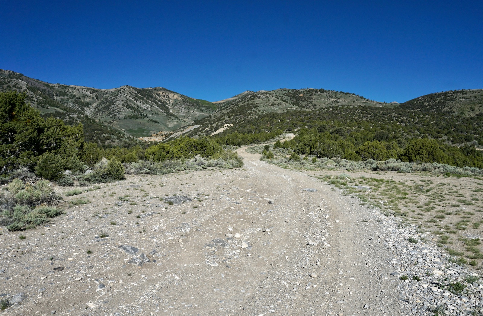
Travel: From the intersection of E Aultman Street and Great Basin Blvd in Ely, drive south on US 50 for 5.4 miles. Turn right one block past the brown sign for Cave Valley Road and the Ward Historic Mining District and measure distance from there. The south-bearing road isn't labeled but it is White Pine County Road 45, Cave Valley Road. Pass a corral at 6.4 miles. Turn west toward Ward Historical Mining District at 6.9 miles. Pass the Ward Cemetery at 8.0 miles. Keep straight at a left fork, 8.2 miles. Pass a sign for the Ward Townsite, 9.1 miles. At 9.2 miles, the 4WD track to Ward Mountain hangs a sharp right. We parked just beyond at a wide spot off the incoming road. It continues up Ward Gulch to the Paymaster Mine. If your goal is Ward Mountain only, you may continue driving up the steep, rubbly road in a capable, high clearance vehicle with 4WD low for 4.1 miles. There are no major obstacles. Park on the ridge top at 10,080 feet and walk from there.
Distance and Elevation Gain: 10.6 miles; 4,600 feet of climbing
Total Time: 6:00 to 8:00
Difficulty: Jeep track, off-trail; navigation challenging; Class 2 with no exposure; hike on a cool day and carry all the water you will need.
Maps: Ward Charcoal Ovens; Ward Mountain, Nevada 7.5' USGS Quads
Date Hiked: June 11, 2021
Total Time: 6:00 to 8:00
Difficulty: Jeep track, off-trail; navigation challenging; Class 2 with no exposure; hike on a cool day and carry all the water you will need.
Maps: Ward Charcoal Ovens; Ward Mountain, Nevada 7.5' USGS Quads
Date Hiked: June 11, 2021
Quote: And if the mountain was the center, you stand now in the middle: between the east where you came from and west where all the light goes down. Peter Anderson, Heading Home
Ward Mountain is the highest point in the 108 mile-long Egan Range named after the Egan family of the 1890s. Ward Mountain encompasses three miles of the ridgeline. The Egans are bounded on the east by the Steptoe Valley and the Schell Creek Range. To the west is the White River Valley and White Pine Range. This image features the Ward Mountain summit from Hamels Peak. (Thomas Holt Ward, photo)
Route: The loop as described goes counterclockwise. From the parking pullout in Ward Gulch, walk roughly northwest up a 4WD track to the summit of Ward Mountain. Hike south, off-trail, to crest Hamels Peak, Peak 10,218', and Peak 10,182'. Navigate eastward to the Paymaster Mine. From there, walk east on the road back to your vehicle. Note: the Ward Charcoal Ovens topo has 20 foot intervals and the Ward Mountain topo has the more standard 40 foot intervals. Thanks to Stav is Lost for the stellar idea of turning Ward Mountain into a four-peak loop hike.

Ward Mountain
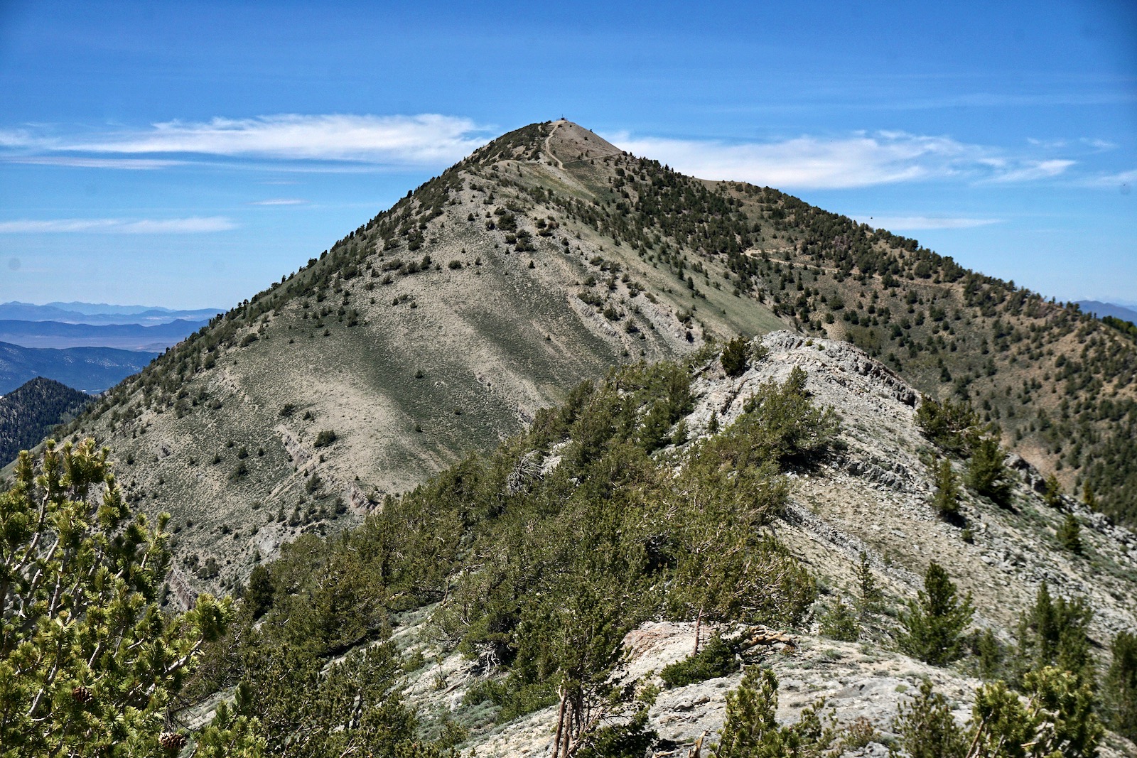
From the pullout at 7,700 feet, walk back down the road a few paces and then turn onto a steep 4WD track going momentarily northeast before switching northwest. While the road makes a few significant switchbacks, in general it bears northwest to the summit. It climbs at a consistent, moderately steep incline over limestone bedrock and cobbles. Below, Peak 10,218' rises left of an aspen forest, the double summit of Hamels Peak just pokes above the foreground hill, and the crest of Ward Mountain is barely visible on the right. (THW, photo)
The dominant cover is ubiquitous West: piñon-juniper, sagebrush, and rabbitbrush. The flora was particularly lush in June, 2021, when wildflowers were peaking. We saw many patches of Indian paintbrush in a range of colors.
(THW, photo)

We were surprised to see lupine growing in the center of the track. We hiked on a weekday and encountered just one group of OHVs. The road sees more traffic on weekends. At 0.9 mile, we stayed on the main road where a much steeper shortcut breaks off.

Pass by a sluice, tank and mine adit at 1.5 miles, 8,800 feet. A steel gate constructed by the Nevada Division of Minerals bars entry. If that isn't sufficient discouragement, scratched on the sign is the following: "An internal survey conducted 6/25/2007 identified LETHAL AIR INSIDE." The eastward slope is terraced with long-abandoned mine roads.

The road makes a sharp switchback to the southwest when it tops the east ridge of Hamels Peak at 1.8 miles, 8,860 feet. This vantage point affords the first full-throttle view of Ward Mountain. After half a mile, the road turns back to the northwest. There is a significant fork at the Defiance Mine (shown on the map) just shy of 2.5 miles, 9,340 feet. Transition onto what appears to be a secondary road, continuing north. We were preoccupied and swung left with the main track. This road heads to the ridge south of Hamels Peak. We climbed almost 500 feet before we woke up and realized we were climbing the wrong mountain. We retraced our steps and subtracted the statistics from the totals presented above. The proper road yields occasional views of Ward Mountain.

The road gives up 80 feet of elevation to head a draw and passes through an aspen forest with arborglyphs dating to 1910. (THW, photo)

The Egan Range is primarily composed of limestone but at 9,700 feet you will encounter a sandstone layer with beige, yellow and red hues. Sweeping, east-facing hillsides are clothed in a uniform mantle of sage. Enter the white pine world with limber pines transitioning to bristlecones.
Gain the Ward Mountain ridge at 4.1 miles, 10,080 feet. If you have driven to this point, this is your one opportunity to park. The road going north is almost flat to begin, but then it pitches radically.

Just before topping out on the summit ridge, the road splits. The left track is the gentler option. Crest the chipped limestone summit dome at 5.1 miles after 3,350 feet of climbing. The radio communication facility detracts from the noble prominence. We searched for the "Ward Small Cairn 2" Benchmark but were unable to locate it. (THW, photo)

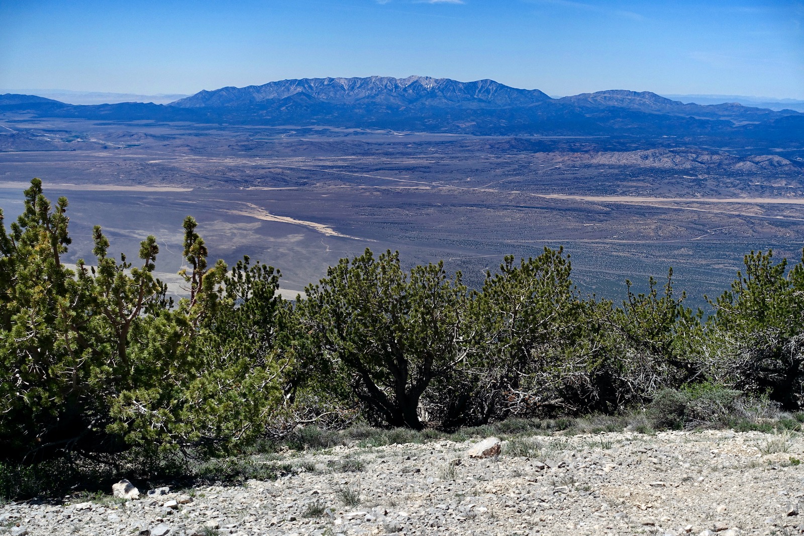
Ward Mountain has a rise of 3,676 feet and the views are superlative. The land ripples east across the Steptoe Valley, up and over the Schell Creek Range into Spring Valley, and back up to Wheeler Peak, 13,065', in the Snake Range. Boundary Peak, 13,147', is the tallest mountain in Nevada; Wheeler ranks second.

Peak 10,803' looks appealing further along on the ridge. Ely rests in the big valley streaming north.

Across the White River Valley is the White Pine Range crowned by Current Mountain, 11,513'.
Looking south, Hamels Peak is image left and Willow Benchmark (Peak 10,302') fascinates with its upended limestone crags.

Hamels Peak, 10,440'
Walk one mile back down the road to upper parking. The remainder of the hike is off-trail. There are some navigation puzzles between the last peak and Paymaster Mine. Trail hikers are advised to retrace steps. For those going on to Hamels, leave the road at 6.1 miles, staying on or near the ridgecrest.

Descend into the saddle, 9,966 feet (Hamels has a rise of 474 feet.), and then work your way up the limestone ridge on broken stone and bedrock. There is mild exposure on the ridgeline; you may wish to stay slightly off the rib.


The false summit is the more dramatic with a stone crest. Sheets of limestone fall away on the eastern slope. The true summit, 7.0 miles, is ringed with bristlecones.
The downclimb on Hamels' south ridge is steep but the footing is good. A group of OHVs came around the east side of Peak 10,218', shown, and then descended east from the saddle. If for any reason you've had enough, bail on this road and in one mile you will encounter the upcoming track at the Defiance Mine.

Peak 10,218'
The next two peaks are simple, effortless walkups. From the saddle at 9,900 feet, ascend the open slope for 318 feet on a chipped-rock surface. Deer and elk inhabit the bristlecone forest. Everything associated with this softly rounded, sweet little mountain has been around for a very long time.
Peak 10,182'
From the summit of Peak 10,218', 7.6 miles, the fourth prominence is remarkably similar, shown. If you persist for the final 322 feet of climbing you will pass by the largest and oldest bristlecones on this circuit.

Descending from Peak 10,218', segue onto the road above the 9,860 foot saddle. A dwelling, now an unsightly trash heap, once stood in front of a decidedly ancient bristlecone. (THW, photo)

Leave the road at 9,900 feet and climb the north slope. The mountain has a limestone cone with a bristlecone crown. Crest Peak 10,182' at 8.4 miles. It appears you could continue south along the ridge, shown. We were tempted by the Willow Benchmark but we needed sufficient time to navigate back to our vehicle.

Return to Trailhead
The drop to the Paymaster Mine is almost 2,400 feet over two miles. There are no obstacles and it took us not quite 1.5 hours. If you are not confident in your navigation savvy, descend north and take the road back to Defiance Mine.
Drop a short distance down the north slope until you get a visual of the subtle east ridge through the trees. We started our eastward descent at 10,100 feet, coincidently near a metal post. The parking pullout and Paymaster Mine are visible.

At 9,880 feet, cross an abandoned road, making every effort to stay on the ridgecrest. Brush is not an impediment. The ridge splits at two prominences, shown. Aim for the saddle between the stone-topped knoll and Point 9,080', image-right. We got some help from big game and stock trails.

Upon reaching the saddle northwest of Point 9,080', locate an abandoned road flanking the prominence on the north. This subtle track bears east and ends at 8,800 feet. The next objective is the northeast ridge of Point 9,080'. The image below was shot from the saddle. The road cut is between the two tallest conifers, image-left.

Keep an eye on the Paymaster Mine. The ridge splits at 8,600 feet; bear north. At 8,300 feet, jog east. We left the ridge at 8,000 feet and bushwhacked down to the mine.

The mine complex is a dump. The only thing picturesque was this curious artistically etched insignia. Hop on the road north of the mine and walk 0.3 mile back to your vehicle.

Personal Note: I've been traveling US 50 between Colorado and California a couple of times every year for six decades. Ely is mid-way and I frequently pause there overnight. My partner, Thomas Holt Ward, was pleased to spend a day hiking on his eponymous mountain. We walked through the Ward Cemetery but didn't see any grave stones with the surname Ward.

The view of the Ward Mountain ridge from the cemetery is wonderful. Seen below are peaks 10,182', 10,218', and Hamels.

Morning sun graces the Egan Range. The four peaks featured on this loop hike are clustered in the center of this image shot from US 50 east of Ely. (THW, photo)

No comments:
Post a Comment