Essence: Climb two informally named Class 3 ranked summits on the Gifford Canyon and Hepworth Wash divide. The hike showcases Zion's diversity of sandstone terrain with creek bed walking, friction pitch slopes, expansive Navajo Sandstone bowls with ponderosa pocket gardens, and scrambles to small-knobbed summits with far-reaching views. Route finding is complicated throughout. A GPX track is helpful; map reading skills are essential. The hike is within Zion National Park. It begins at the east entrance of the Zion-Mount Carmel Tunnel and heads south in Gifford Canyon.
Travel: Park in the first paved lot east of the tunnel on the south side of Highway 9. The 9-space lot fills early, around 7:00 am. There are additional pullouts further east on the highway. You must turn right out of the lot at the end of the hike. There was a major backup at the tunnel so we traveled miles up the road before we could turn around and get back in line. Vault toilet, no water.
Travel: Park in the first paved lot east of the tunnel on the south side of Highway 9. The 9-space lot fills early, around 7:00 am. There are additional pullouts further east on the highway. You must turn right out of the lot at the end of the hike. There was a major backup at the tunnel so we traveled miles up the road before we could turn around and get back in line. Vault toilet, no water.
Zion National Park: Visit the website for information on fees and campground reservations.
Distance and Elevation Gain: 6.6 miles; 2,600 feet
Total Time: 5:00 to 7:00
Distance and Elevation Gain: 6.6 miles; 2,600 feet
Total Time: 5:00 to 7:00
Difficulty: Off-trail; navigation challenging in complex terrain; Class 3 with moderate exposure (can get into extreme exposure without any difficulty); hike on a cool day and carry at least four liters of fluids; wear shoes with good grip.
Reference: We referred to a track from a friend who did a technical climb up Gifford Peak followed by the scrambles up Hepworth and Roof. AllTrails has a description of this hike by an individual familiar with Zion. The site has an annotated GPX file you may download. The author provides alternate ascent lines to both peaks and a descent route from the Hepworth-Roof drainage into Gifford Canyon.
Map: Springdale East, UT 7.5' USGS Quad
Date Hiked: May 17, 2023
Poem:
Map: Springdale East, UT 7.5' USGS Quad
Date Hiked: May 17, 2023
Poem:
If we surrendered
to earth’s intelligence
we could rise up rooted, like trees.
Rainer Maria Rilke
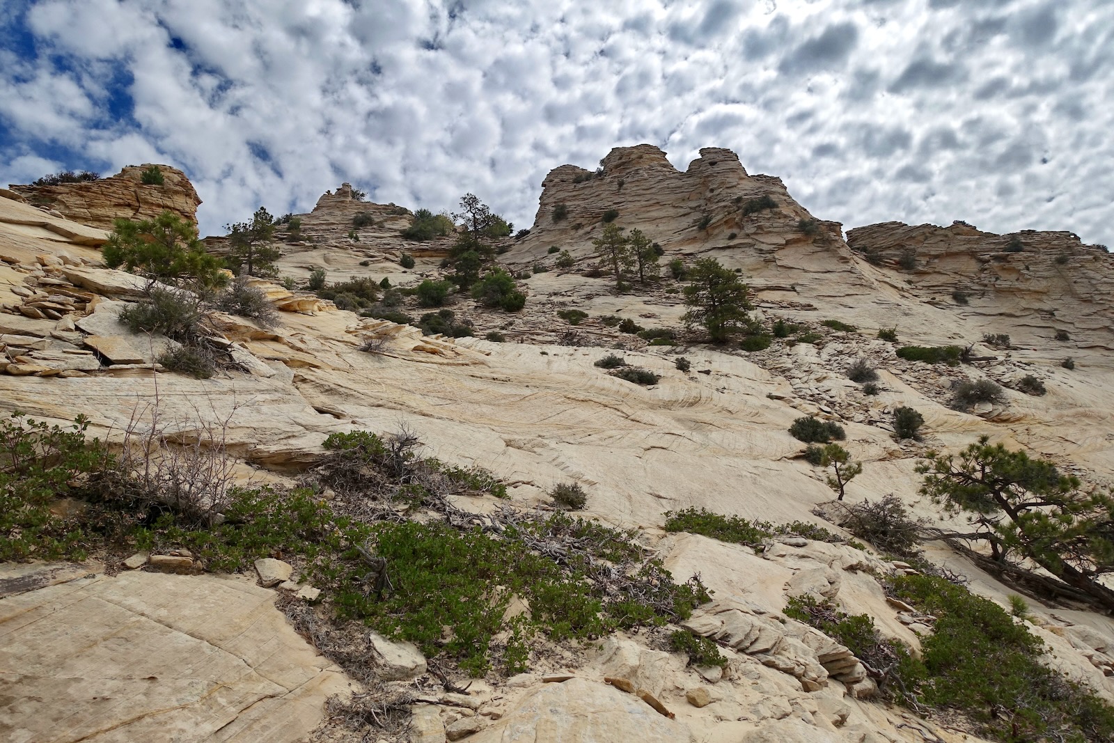
On Roof Peak the great immensity of Navajo Sandstone covering the Colorado Plateau to a thickness of 2,400 feet has eroded to reveal cross-bedding laid down in ages past. The apex is but a stacked array of thin disks poised to slide off the mother rock. The route comes up the pitch on lower left.
to earth’s intelligence
we could rise up rooted, like trees.
Rainer Maria Rilke
On Roof Peak the great immensity of Navajo Sandstone covering the Colorado Plateau to a thickness of 2,400 feet has eroded to reveal cross-bedding laid down in ages past. The apex is but a stacked array of thin disks poised to slide off the mother rock. The route comes up the pitch on lower left.

Route: Hike south-southeast in Gifford Canyon for one mile. Mount 500 feet out of the creek to the west and bear southeast through complex terrain to the saddle between Gifford Peak and Point 6,260'. Drop south to the drainage between Hepworth and Roof peaks. Climb west to their shared saddle. Hike roughly north to Hepworth and south to Roof. Retrace steps. Note: the Springdale East quad has 80-foot contour intervals so the terrain is steeper than it appears on this map.

The hike begins literally steps from the east entrance to the Zion-Mount Carmel Tunnel at elevation BM 5,124 feet.

Get your bearings. The image below was shot from parking. It looks down on the confluence of Pine Creek coming from the east and Gifford Canyon which ends at a pouroff, the crack at image-center. The bypass slab is left of the crack. Locate a rubbly trail dropping into the wash just before the vault toilet.

Absent advance information we merrily walked a few paces up Pine Creek, pictured. Heading east was not the plan so we backed out. Yes it is beautiful but it's the wrong canyon.


Rather, once past the pouroff mount the inclined slab, shown. At the top of the pitch a use trail bears south and wraps west into the creek bed above the dryfall.

This image looks from the top of the dryfall into a pool of early morning shade. The confluence of the two canyons is directly below, plus the talus "trail" from the parking lot. Shelf Point and Mind's Eye, the terminus of the southeast ridge of The East Temple, radiate dawn sun. (Thomas Holt Ward, photo)

Bear south in Gifford Canyon, a narrow idyllic streamway with a flat sandy floor and towering walls. It was a wet spring--footprints and deer tracks were imprinted in damp sand, ferns lined the riverbanks. (The sand may well be an impediment when dry.) Soaring ponderosas were fragrant with the scent of vanilla. (THW, photo)

At 1.0 mile, 5,200 feet, arrive at a 200-foot vertical wall that serves as an unmistakable landscape marker. Leave the creek here making a hard right to the west.
 There are a couple of good exits from the waterway.


Climb 500 feet up the steeply inclined slope. This segment of the hike was the most difficult for me mentally. The friction pitch worked the edge of my ability to stick to the rock. We found shallower terrain on our downclimb, shown on the map above. Pick your line thoughtfully. Work your way up the center toward the high cliffs at the top of the pitch. There were a few cairns, too sporadic to be of much help.

As you approach the top of the slope, you'll see a couple of cracks
going south. You want the deepest one with the tallest sheer wall at about 5,720 feet. It is accessed by a short, rubble ramp doubling as a social trail.

You'll be able to reach out and skim your fingers along the vertical wall on your right. (THW, photo)

When the crack gets cluttered with brush, turn up onto a ridgelet with an eastward vista. Pictured below is the inclined slope emerging from Gifford Canyon, the vertical wall at the turnout, and the water line plunging down from the Jenny Peak massif. (THW, photo)

Still on the ridgelet, follow a sandy social trail south up to a little reprieve at 5,800 feet. Turn northwest and climb the stone nose, image-right. (THW, photo)

At about 5,880 feet, you will come to a boulder with two micro arches, shown. There may be cairns heading further up the nose (leading to climbs west of Hepworth Wash). Ignore them and crank a hard left heading a small drainage. Continue following the trail south.

The path leads into an open bowl northeast of Gifford Peak, the white prominence at skyline, shown below. Contour around to the back of the basin holding 5,880 feet. It is a great pleasure to walk on the natural shelf where big trees have taken root on bedding planes. The incline to the bowl's rim is shallowest at the waterway.

We climbed southwest alongside a slip of water. This moderately steep ascent isn't as challenging as the friction pitch out of Gifford Canyon. (THW, photo)

Emerge from the bowl onto a terrace below the east cliff face of imposing Gifford Peak.

The route bears south passing the gap between Gifford and Hepworth while staying west of Point 6,260'.
The cryptobiotic soil on the terrace must be avoided. We used the rock runner, shown, on our way to the peaks. It put us a little high so we corrected on our return, using another swath of rock further west. 
From the Hepworth-Point 6,260' saddle at 2.3 miles, 6,200 feet, we had our first view of the all-stone summits of Roof and Hepworth. Exciting and wondrous!

The route continues south along the base of the east face of Hepworth. Give up about 200 feet to contact the drainage between the two mountains, 2.7 miles, 6,000 feet. (THW, photo)

Enter an elemental world of stone and ponderosa.

The fractured purple blocks and cubes resting on the surface are floaters from a terrace north of the bowl.

The bowl pitched up as we closed in on the rim. Our favored route with the shallowest incline (and impossibly beautiful) was on the north side of the bowl. (THW, photo)

Arrive on the Hepworth-Roof saddle at 2.9 miles, 6,200 feet. Below, Hepworth's west ridge is image-left and the peak is hidden by the prominence on the right.

Hepworth Peak,
The peak has a rise of 320 feet from the saddle and took us 20 minutes to achieve. I will describe our route but please see AllTrails for alternative choices both up and back. From the saddle we headed northwest staying west of the three-knob prominence, shown.

Below, I'm ascending the west slope. Due west, red Stevensworth Peak rears radically up out of Hepworth Wash.
(THW, photo)

We decided to make the final approach from the west ridge. We were forced to bypass an obstacle on the north. Exposure on the workaround was serious and the footing poor on sliding rock. Committed, I climbed the summit stack from that approach, a nice little scramble, pictured. I thought it unlikely that the tiny nubbin was the highpoint but indeed it was. 

I recommend that you approach by way of our descent route. From the saddle, work your way up toward the west ridge but stop short and climb east to the left side of the aforementioned three-knob prominence.
Claw your way up through sliding slabs to the right of the ponderosa, shown. While it is something of a nuisance, it's the safest alternative.

You will arrive in a pocket garden with the peak an easy 50-foot scramble to the north. This image was taken from the top of the sliding slab pitch.

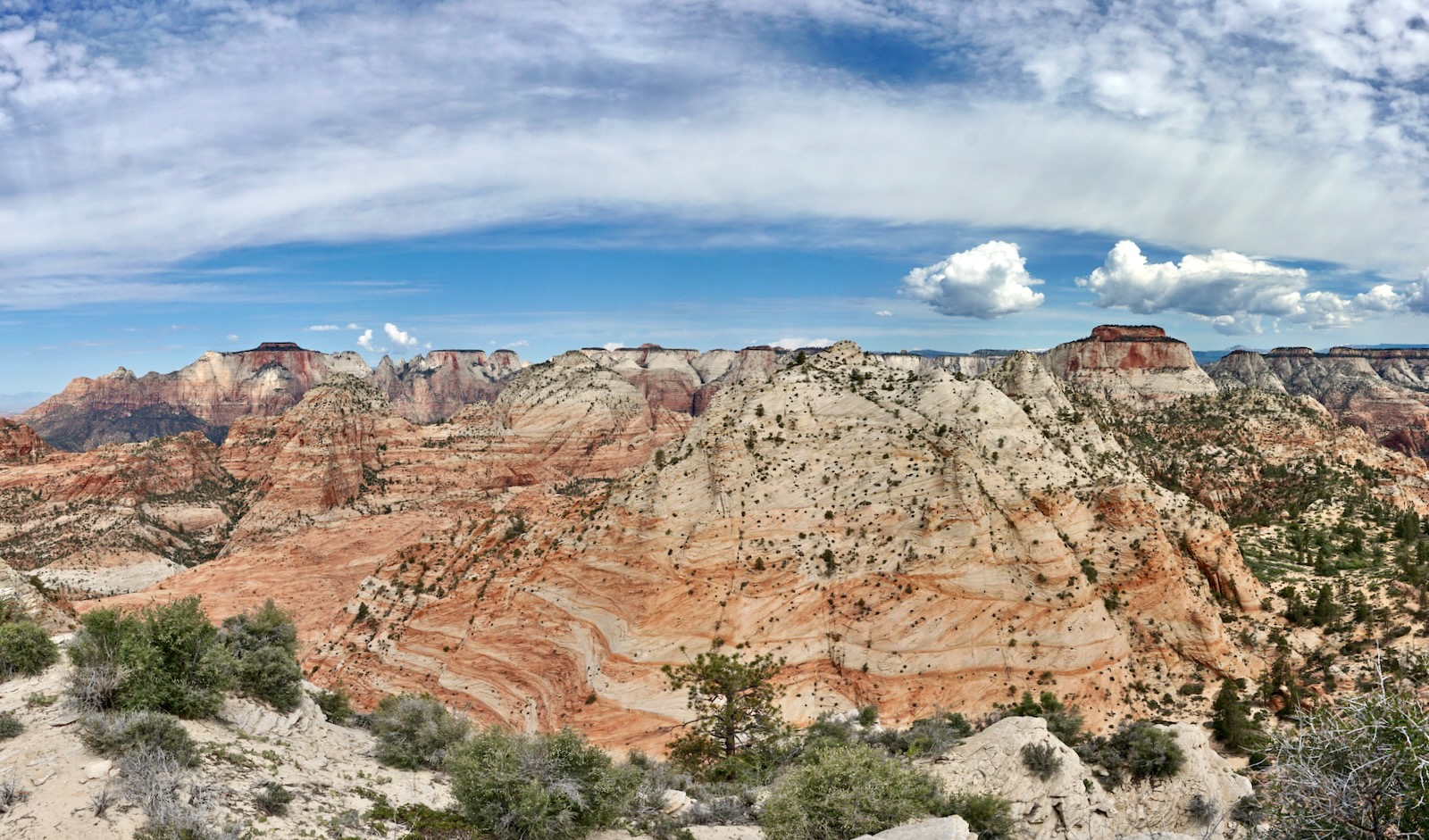
The Hepworth Peak zenith is about three feet in diameter with room for two people. We topped out at 3.2 miles. The westward view encompasses innumerable sandstone peaks and yet they are but a fraction of the ranked summits within the park. This panorama swings from Mount Kinesava, The West Temple, companion Gifford Peak, and The East Temple. The radical color variation in Navajo Sandstone is one of its most appealing attributes. (THW, photo)
Below, I'm standing on the slightly more roomy sub-knob. The recommended route comes up between the two summit stacks. The image captures the view to the southeast. You can surmise the location of the East Fork of the Virgin River in front of the purple cliffs. (THW, photo)

Roof Peak is the neighboring summit to the south. Seen from Hepworth, there are two principal prominences. Point 6,542' (on the left) is marked on the Springdale East quad. However, the highpoint is on the west buttress, the pointed dome second from the right. Please see Lists of John for an explanation of the extrapolated calculation of its height at 6,551 feet and rise of 431 feet.

Roof Peak
Return to the saddle and climb south. We mitigated the incline by favoring the west ridge but you may wish to cut the arc short and aim directly for the peak. Our route took us up through the two summit knobs, image-left.

Ebony black iron concretions are scattered about on swaths of coral sandstone.

There's nothing tricky about this climb. I found it easier than Hepworth and very quick. The only dicey bit is the final friction pitch between the summit domes.

Roof Peak extends well to the east, rolling over Point 6,542'. The highpoint is unmistakable when you get up there. It is shown in the feature photo of this post. The form of the little apex is aesthetically incomparable and the views are sensational. It's an easy scamper up onto the west stack overlooking the Stevensworth ridge and Parunuweap Canyon. (THW, photo)


Given the melding of forms and color it's a little hard to sort out the westward view. In the midground at center is G2 and the higher peak to its right is Bridge Mountain. Both climbs originate in Gifford Canyon and climb the 500-foot friction pitch just as we did.

In this image Hepworth Peak is directly in front of The East Temple. You can see the terrace that the purple chunks of rock eroded from.

Ominous thunderheads were developing so we left a summit register near/under the peak cairn and scurried off the mountain. We had an excellent look at the summit of Hepworth from the west ridge of Roof. (THW, photo)

Navigation guesswork behind us, we maintained a quicker pace back to the trailhead. This image was taken as we flanked the east side of Hepworth. We managed to hone a cleaner line west of Point 6,242' but you'll be climbing no matter how you work it.

We planned to search for a scrambler's route up the south face of Gifford Peak but cracks of thunder in the near distance were nerve-racking. We discarded the idea and booked it back to the trailhead moments ahead of the rain.

Blooming flowers were plentiful. My favorite was the fragrant white sand verbena. (THW, photo)

2 comments:
These are beautiful peaks, a bit more of a challenge than Progeny. I found navigation around the big bowl above Gifford Canyon to be hard; the first time I got distracted by some cairns which took me over to Pk 6408 - which is perfectly nice. In fact I went back there in 2022 and noticed that the cairns were gone (good thing I save my GPS tracks). Once past the bowl, navigation is easier. Glad you got to enjoy this one.
So good to hear from you Mojave Ben. Thank you for your helpful comments on these delightful peaks of Zion. Debra
Post a Comment