Essence: Table Top is a flat-topped summit in south central Arizona easily recognized region-wide. It is the highest point in the Table Top Mountains, rising 2,338 feet above Vekol Valley south of I-8. The very old, well-engineered trail is smooth and friendly to start, then steep and rubbly as it closes in on Point 4,356', a subsidiary summit just 17 feet lower than the Table Benchmark. Strong hikers will have no trouble reaching the initial prominence and going on to the highpoint of the 34,400-acre Table Top Wilderness. The wilderness lies within the 486,000-acre Sonoran Desert National Monument designated to protect dense stands of saguaro cactus, paloverde, and ironwood trees. A 40-acre island of Sonoran Desert Grassland graces the summit of Table Top. Both the wilderness and national monument are administered by the Bureau of Land Management. A brief description of nearby Antelope Peak follows.
Travel: From I-8, take Exit 144, Vekol (Valley) Road and turn south. Measure distance from the cattle guard on the south side of the interstate. To start, the road is wide and well-graded. Take seriously the sign, "Smuggling and illegal immigration might be encountered." At 2.0 miles the road splits at a Y. Abandoned Vekol Ranch is to the left. Bear right, following the sign for the Table Top Trailhead on BLM 8007. Enter the Sonoran Desert National Monument. The road degenerates. Moderate clearance with good approach and departure angles is required to manage sharp dips into shallow washes. Swing left at 7.4 miles, staying on BLM 8007. The track is well marked with "Trail" signs. At 10.6 miles, turn left at a corral onto BLM 8024 and immediately cross a yellow cattle guard. Pass the Lava Flow Trailhead at 14.1 miles. Table Top Trailhead parking is on the right at 14.9 miles. Allow 45 to 50 minutes from I-8. Your mileage is likely to vary. Pit toilet, no water. There are three lovely campsites with picnic tables, fire pits, no fees, pack out your trash.
Distance and Elevation Gain: 9.2 miles; 2,500 feet
Total Time: 5:00 to 6:30
Difficulty: Trail; navigation easy; Class 2; no exposure; Carry all the water you will need and hike in cool months to avoid scorching temperatures and rattlesnakes.
Maps: Little Table Top; Indian Butte, AZ, 7.5' USGS Quads
Latest Date Hiked: March 2, 2024
Total Time: 5:00 to 6:30
Difficulty: Trail; navigation easy; Class 2; no exposure; Carry all the water you will need and hike in cool months to avoid scorching temperatures and rattlesnakes.
Maps: Little Table Top; Indian Butte, AZ, 7.5' USGS Quads
Latest Date Hiked: March 2, 2024
Quotes: Saguaros are people, too. Tohono O'odham saying.
The actual understanding of saguaro by the Tohono O’odham and their ancestors—it just far, far, far eclipses the understanding we have now. Ben Wilder, Director, University of Arizona’s Desert Laboratory
Evening twilight accentuates the pleated ribs of the saguaro and glistening creosote. Ephemeral drainage channels slash the west slope of Point 4,356'. Bajadas soften the landing as the mountain crashes to a halt on the desert floor. (Thomas Holt Ward, photo)

Route: The Table Top Trail bears northeast to elevation 3,200 feet where it switchbacks steeply up the southwest slope of Point 4,356'. From the subsidiary summit, a well-established social trail descends east into the saddle south of the benchmark. The path ascends gently along the east rim of the "table." Upon reaching elevation 4,280 feet, there are a couple of simple route choices to finish the climb.

A tribute to the Table Top Wilderness contained within the Sonoran Desert National Monument is displayed on a placard at the trailhead. Please note leashed dogs are allowed in the campground but not on the Table Top Trail. (THW, photo)
A tribute to the Table Top Wilderness contained within the Sonoran Desert National Monument is displayed on a placard at the trailhead. Please note leashed dogs are allowed in the campground but not on the Table Top Trail. (THW, photo)

Point 4,356'
The trail is open to hikers only--no equestrians, no bicycles, and no motos. The fence seen below delineates both the wilderness boundary (straight ahead) and the adjacent Tohono O'odham Nation (on the right). In recent history, smugglers have traveled north on reservation roads. In 2005, I hiked solo to the Table Top summit. It was my first exposure to piles of migrant trash. In 2024, the trash was present to a lesser degree. Nevertheless, we were nervous spending the night in the remote campground prior to our hike. An abandoned two-track bears northeast from the Table Top Trailhead, elevation 2,300 feet.

In early March the colors were predominately two-tone black and green. The earth was covered with a uniform mantle of spring-green grass. The old road tracks between two prominences, their black volcanic boulders composed of basalt, andesite, and dacite. Southeast of the trail is UN 3,020'.

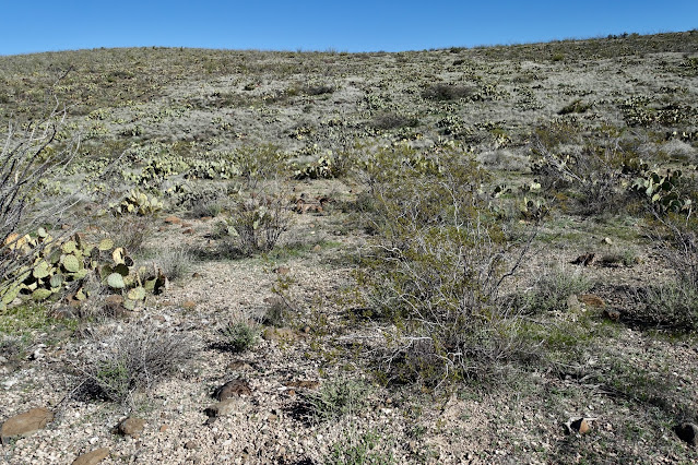
Flora is packed in tight and lush with many cholla varieties, pricklypear, paloverde, saguaro, ocotillo, fishhook barrel, brittlebush, ironwood, and agave. We were ahead of the spring bloom. On my first visit I arrived during a superbloom. Astounded, I titled the hike, "A billion buds and blossoms." Even without the flowers, the pathway is incredibly beautiful and friendly. The desert floor is uniform gravel with surprisingly little rock. Judging from the evidence, wild horses run on the land. Below, dawn light quickens Point 2,911', one big boulder pile.

The old road necks down to a single-track at an incredibly charming trailhead sign and register at 0.6 mile. I'm guessing the trail once began here at the end of the road. The sign-in sheets are rather fascinating. This is clearly a popular hike and yet, we saw only two people all day.

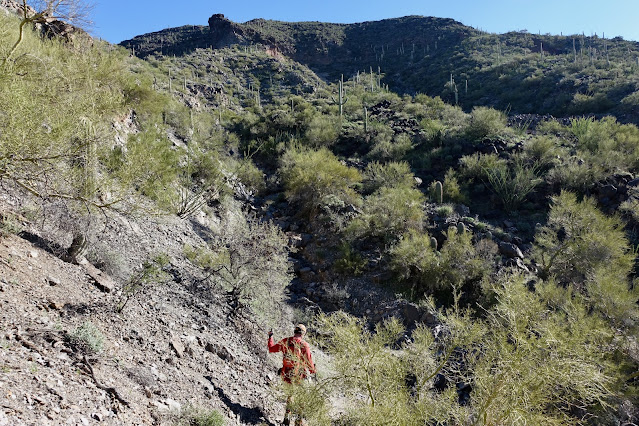
The trail crosses three washes, the first at 0.9 mile. Climb out of the drainageway and onto the bajada. The path winds between weathered volcanic boulders pocked with air holes. The way (just to be sure) is marked with large rock cairns piled up long ago. The mountain is constantly visible out in front.

Initially unsure, we speculated the route's course up the mountain. Notice the two principal fans on the lower flanks. The trail switchbacks up the fan on the left. It crosses the ravine below the erosion scar and then climbs up the southwest slope to rounded Point 4,356'. The highpoint and benchmark remained out of sight until we were closing in on the subsidiary peak.

Following the undulations in the landscape, the well-crafted trail drops into and back out of another streamway at 1.8 miles. In the park-like setting saguaros stood out as the keystone species. They were thriving in every stage of development--youthful, mature, elder, ghost, and skeletons on the ground. Saguaros are the American Southwest. (THW, photo)

The enrapturing fairyduster is an early spring bloomer. (THW, photo)

At 2.2 miles the footbed is composed of caliche, a hardened natural cement of calcium carbonate. It seems as if caliche is holding the mountain together. The climbing pitches up as the path begins switchbacking up the aforementioned fan. At 2.9 miles, 3,260 feet, the trail cranks to the east and drops into the third and final drainageway.
The ravine is braided by ribs of alluvium. It doesn't rain often in the Sonoran but when it does water has the power to carry boulders.

The trail passes adjacent to the eroded slope first glimpsed from the bajada.

Zigzag steeply up the southwest slope. Retaining walls ardently hold up the trail. (THW, photo)

At 4,100 feet, the trail runs parallel to four-foot-tall walls of loosely piled stones running for considerable distances. According to the Bureau of Land Management, the origin and purpose of the walls remains unknown. (THW, photo)

The walls curl down the mountain. (THW, photo)

Climb amongst big boulders at the upper limit of the saguaro zone. (THW, photo)

The mountain rounds off. Looking back, the trailhead and parking is visible between the two volcanic prominences. On the right is Black Mountain. The Lava Flow Trail runs along its western base on the fringe of the Vekol Valley.

Arrive on Point 4,356' at 3.8 miles. As expected, it is a massively broad summit platform with a good perspective on the benchmark. Varieties of yucca have taken the place of the saguaro. The function of the solar powered device is a puzzle. (THW, photo)

Table Top, 4,373', Highpoint and Benchmark
It is 1.6 miles roundtrip to the peak with about 480 feet of elevation gain, taking 1:00 to 1:20. The footpath is not engineered or maintained but it is a good social trail beginning just off the north side of the ridge.

Give up 176 feet to the low point in the saddle at 4,180 feet. The island of Sonoran Desert Grassland is abundant with pricklypear. You could certainly walk through the thorny tangle directly to the summit but we opted to continue painlessly on the trail.
The splendid footpath provides a tour of the east side of the table.

This image was shot on our return. It depicts sky islands to the east of the Table Top Mountains. Many of the ranges seen below are within the Papago Indian Reservation on the Tohono O'odham Nation. (THW, photo)

The east rim of the mountain drops off in a hurry.

The top of the mountain is nearly flat (as expected) with big, dark volcanic boulders. The trail wraps around to the north side of the subtle summit and ends at another little mysterious device. We easily cut up to the summit off-trail and by chance bumped into Reference Mark No. 2.

We arrived at the Table Benchmark at 4.7 miles. It is located on the highpoint of the aptly named summit in a depression within a ten-foot circle of stones. We searched for a peak register to no avail.

The Table Benchmark was placed in 1910. (THW, photo)

We could see I-8 and irrigated agricultural land to the north and east, as well as Antelope Peak. This image looks back on Point 4,356'. To return, we took a shortcut by walking east and soon intersected the social trail.

That put us back on Point 4,356' at 5.4 miles. Moving downhill, the upper mountain is slick and loose with marbles and babyheads jostling underfoot. We didn't notice it hiking uphill but the slope is just steep enough to require some concentration on the way back down. This cheerful trailing windmill brightened progress. (THW, photo)

Antelope Peak, 3,117'
Essence: The west ridge route up conical Antelope Peak pairs nicely with Table Top. Both summits are east of the Vekol Valley and within the Table Top Wilderness. With a rise of 857 feet the peak has unobstructed views and a clean shot over to Table Top. Approach in an unnamed wash and then pitch up a steep and rubbly ridge off-trail. Caution: We walked by mounds of migrant trash throughout the hike.
Travel: Travel to Antelope Peak parking begins as for Table Top. From I-8, take Exit 144, Vekol (Valley) Road and turn south. At 2.0 miles the road splits at a Y. Measure distance from there and take the left branch (BLM 8044) toward the Vekol Ranch. At 0.4 mile cross several braids of wide Vekol Wash. Pass ranch buildings sadly falling into ruin. At 0.6 mile the road jags to the left within the ranch. Stay straight when the road splits at 2.0 miles. The track gets so narrow, desert pin-stripping is inevitable. Thread between chainfruit cholla. Windows up! 4WD with decent clearance is needed to get down into and out of washes. Hang a hard right onto BLM 8042C at 2.2 miles, right after a creek crossing. Park at 3.0 miles at a sign, "Closed to all motor vehicles."
Distance and Elevation Gain: 5.0 miles; 1,150 feet
Total Time: 3:00 to 4:00
Difficulty: Off-trail; navigation moderate; Class 2+ with no exposure; Carry all the water you will need and avoid during sizzling snake season.
Map: Antelope Peak, AZ 7.5' USGS Quad
Date Hiked: March 4, 2024
Route: Antelope Peak is on the Southern Arizona Hiking Club peak list. They approach the summit via the north ridge. The route described below is quick and direct. From parking, walk south in a drainageway and branch east at first opportunity. Stay in the wash until you are adjacent to the west ridge of the peak. Ascend the ridge to the summit.
The isolated and uniform profile of Antelope Peak attracts from the parking pullout at elevation 1,980 feet. Step to the right and get into a large (and likely dry) shallow wash heading south.

At 0.4 mile, the drainageway splits. Branch to the east and stay in the wash all the way to the west ridge. It proved to be faster than our initial attempts to shortcut.

Leave the wash and begin climbing the west ridge at a place that looks appealing to you, at roughly 1.75 miles, 2,120 feet. Volcanic boulders of every size are intermixed with teddybear cholla and assorted spiny plants--basically all the typical Sonoran fun stuff. I was charmed by a short spurt of straw-colored fairy grass growing amongst black boulders.

The ascent is straightforward. Walk over a knoll at 2,640 feet.

If you prefer trails to guide you through prickly cactus and teetering boulders, this short off-trail blast is probably not for you. But for those who thrive on the raw desert experience, just keep charging up the ridge.

Pass just to the right of a small southwest facing cliff.

It is steeper and rougher above the cliff and the boulders are unstable. Take care for those below you.

Alight on the summit cone at 2.5 miles. It's a sweet little flat top about 12 feet in diameter. Look south to the two lobes of Table Top (shown) and north to linear I-8 stretching across the desert.

The first 200 feet of descent is more difficult going down than up. Big rocks roll underfoot. Back in the wash, keep an eye out for an unusual rippling saguaro.

No comments:
Post a Comment