Essence: Link four superbly crafted, well-signed trails to create a loop hike cresting on Hunter Peak. While the circuit may be hiked in either direction, we prefer to ascend on the stairstep Bear Canyon Trail with its gorge-restricted topography. Descending on the Tejas Trail generates wide-open views for the entire distance. A short spur from the Bowl Trail (linking Bear Canyon and Tejas trails) mounts the summit of Hunter Peak, ranked sixth in Texas. With a rise of 548 feet, from the Pine Top Benchmark look across Pine Spring Canyon to Guadalupe Peak, the "Top of Texas." The Guadalupe Mountains extend for 40 miles from far West Texas to New
Mexico. The park was established in 1972 to celebrate and preserve the
four highest mountains in Texas and a glowing white limestone reef born within an ancient sea. The hike is within the Guadalupe Mountains Wilderness managed by the National Park Service.
Travel: Guadalupe Mountains National Park is located in West Texas on
Highway 62/180. Turn west into the Pine Springs Visitor Center and
follow the paved road past the campground. The trailhead is at the far
end of the RV camping area. Restrooms and water are available at the
trailhead.
Distance and Elevation Gain: 9.2 miles; 2,850 feet
Total Time: 5:00 to 7:00
Difficulty: Class 2 trail; navigation easy; no exposure; Carry more food and water than you think you will need and hike on a cool day.
Distance and Elevation Gain: 9.2 miles; 2,850 feet
Total Time: 5:00 to 7:00
Difficulty: Class 2 trail; navigation easy; no exposure; Carry more food and water than you think you will need and hike on a cool day.
Fees and Park Information: Please consult Guadalupe Mountains National Park.
Display an Interagency Pass in your vehicle or pay the entrance fee at
the visitor center or trailhead. The campground is reservation only.
Geology:
The Guadalupe Mountains are composed of a resistant fossilized reef that
formed 260-270 million years ago during the Permian period while
modern-day Texas and New Mexico were submerged under the sea. The
waters evaporated over time but the 400-mile-long Capitan Reef remained
entombed for eons under sediment. Faults over the
last 20 million years caused a portion of the Capitan Reef
to rise several thousand feet. Overlying sediments eroded exposing the
Capitan limestone composing the modern Guadalupe Mountains. Map: Guadalupe Peak, TX 7.5' USGS Quad
Date Hiked: April 10, 2024
Quote: If by some fiat I had to restrict all this writing to one sentence, this is the one I would choose: The summit of Mt. Everest is marine limestone. John McPhee
Quote: If by some fiat I had to restrict all this writing to one sentence, this is the one I would choose: The summit of Mt. Everest is marine limestone. John McPhee
I am partial to mountains composed of limestone. As seen from "Around the Bend" on the Guadalupe Peak Trail, the summit block of Hunter Peak is wrapped in limestone armoring. The Tejas Trail is well to the west of the peak (image-left), its lengthy switchbacks cleaved into stone covered with a thin mantle of vegetation. It was this appealing view of Hunter and the Tejas Trail that inspired us to climb the peak.

Route: The counterclockwise loop links four trails plus the summit spur. From the Pine Spring Trailhead hike north on the Tejas Trail. Transfer to the Frijole Trail and skirt the southeast ridge of Hunter Peak. Ascend northwest up a ravine east of the peak on the Bear Canyon Trail. Hike west on the Bowl Trail to the southeast bearing spur to Hunter Peak. Continue west on the Bowl Trail to the Tejas Trail. Descend south and east back to the trailhead.

Hunter Peak is visible over 2,500 feet above the parking lot and trailhead, image-center-left.

Four trails leave from the Pine Spring Trailhead, elevation 5,840 feet. Hunter Peak is not signed until the summit spur leaves the Bowl Trail. On the day we hiked a park volunteer talked us through the succession of trail transfers necessary to summit Hunter.

About 40 feet from the trailhead branch right on the Tejas Trail. "Tejas is the Spanish spelling of a Caddo word taysha,
which means 'friend' or 'ally'. In the 17th century
the Spanish knew the westernmost Caddo peoples as 'the great kingdom
of Tejas' and the name lived on to become the name of the 28th state
of the United States--Texas."

The trail dips into Pine Spring Canyon and heads down the broad and shallow dry waterway for about 100 feet on chipped limestone. (Thomas Holt Ward, photo)

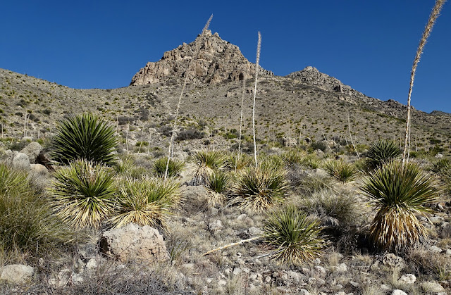
At 0.3 mile, transition to the right on the Frijole Trail. This junction is where the loop concludes at the end of the hike. The Frijole Trail bears east and then north around the base of the southeast ridge of Hunter Peak, shown. The highway is audible running along parallel to the trail on the Chihuahuan plain. Already the rich community of plants include pricklypear, alligator juniper, varieties of yucca, agave, walking-stick cholla, snakeweed, and beargrass. Judging from the spent flower stalks seen below, in 2023 sotol had a vigorous blooming year.
Continue on the Frijole Trail when the Foothills Trail joins from the right at 0.6 mile. The rocky footpath begins its ascent. Large boulders beside the trail are pockmarked with karst. At 1.2 miles, 6,080 feet, cross a beautiful block-filled ravine. Upper Pine Spring is below the trail near the contact between sandstone and limestone.

Leave the Frijole Trail and turn left onto the Bear Canyon Trail at 1.5 miles, 6,180 feet. The trail
bears northwest and climbs steeply for 1,800 feet, ending at the Bowl Trail running along the top of the headwall in 1.8 miles.

Mount the stone staircase. The grade of the treadway mimics the canyon with the exception of precisely one welcomed switchback at 6,240 feet. (THW, photo)

The trail's objective is the rim of The Bowl, a depression to the north. Hunter Peak is the highest point along the rim.

The steep-walled canyon dazzles with fascinating limestone features. Some are robust and topped with globular nubbins.

This stone creature is notably delicate as it clings to the mother rock with all its adhesive power. (THW, photo)

The trail crosses Bear Canyon at 2.0 miles, 6,520 feet, and remains on the east side of the gorge for the duration. Notice the commendable stonework as the pathway climbs up the wall. (THW, photo)

Running alongside the retaining wall seen below, and indeed along the length of the gorge, is a steel water pipe. The park volunteer and a ranger versed in park history said that Hunter Peak was named after rancher J. C. Hunter and his son who owned the Guadalupe Mountains Ranch in the 1930s. Their ranch is now within the national park. They strung the pipe from Upper Pine Spring clear to the top of the rim where they assembled a stock tank to water the goats they kept in The Bowl during the summer. (THW, photo)

At 6,800 feet ponderosa pines shade the trail. The ravine narrows and pitches more steeply. Pass beneath an overhanging smooth limestone wall with characteristic water stains. (THW, photo)

Huge boulders clog up the rough and tumble floor of the ravine. The trail mounts stone risers and boulders wedged between humongous bruisers on either side of the passageway.

Still 1,000 feet below the rim, at 7,000 feet the trail pulls away from the canyon floor and, given more room to work, switchbacks to moderate the grade. Of personal note, four days prior to this successful hike, we made an attempt on the peak. At 7,500 feet we turned around because the wind was so ferocious it was hard to stay on our feet. We later learned 75 mph gusts were whip-lashing Hunter Peak. It's hard to truly appreciate Nature when you are in survival mode so it was a good call to abort and return.

This image looks down from the rim on the switchbacks in upper Bear Canyon. (THW, photo)

At 3.3 miles, 8,000 feet, the Bear Canyon Trail terminates at the Bowl Trail. Turn left for Hunter Peak. If you'd like to see an historic site, turn right and walk 0.1 mile to the stock tank. The concrete, metal sheets, and bolts were brought up on the backs of men and mules. (THW, photo)

Return and walk southwest on the Bowl Trail through heavy timber. The woodland is a lush array of trees typically found in the park:
piñon pine, Chihuahua white pine, Douglas fir, alligator juniper, ponderosa pine, and
Arizona pine. It was too wooded to see The Bowl well enough to take a photo. It is labeled on the Guadalupe Peak topo map and appears to be an extended depression. Below, Hunter Peak is cloaked in conifers on its north-facing slope.

Reach the Hunter Peak spur trail at 3.9 miles (assuming you took the 0.2 mile historic spur), elevation 8,260 feet. This sign is the only mention of Hunter Peak on the entire circuit. The 0.1 mile spur to the summit is effortless. Don't pass it up unless electrical storms are in the vicinity.

Ascend the last 90 feet up the northwest slope on a good trail.

Step off the trail to look through dramatic and precipitous cracks in the south-facing cliffs. Below, I'm approaching the summit of Hunter Peak. (THW, photo)

Arrive on the flat block and roomy summit at 4.0 miles. Scamper around being mindful of the abrupt cliff edge--there is a lot to take in. The peak rises 4,400 feet above the Chihuahuan Desert splayed out to the east and south. (THW, photo)

Pine Top Benchmark was placed in 1943. We could not locate a peak register. (THW, photo)

Look across Pine Spring Canyon to see the Guadalupe Peak Trail go "Around the Bend," zigzag up to the El Capitan plateau, and continue to the tallest mountain in the state of Texas.

All Texans can take pride in this image. Lined up together are Guadalupe Peak (8,749'), Shumard Peak (8,615', ranked No. 3), and Bartlett Peak (8,508', ranked No. 4). In the foreground the Tejas Trail passes in front of Point 6,756', a thin limestone fin.

Facing west, look past Hunter Peak's south-facing escarpment to Bush Mountain (8,631', ranked No 2). Strong hikers could conceivably run out the Bush Mountain Trail and tag that peak before completing this loop. (THW, photo)

Return to the Bowl Trail at 4.1 miles and turn left. The path bears due west occasionally balancing right on top of the rim. If you study a trail map you'll see that the Bowl Trail dives into the depression at the stock tank and then returns to the rim. We met up with the west end of that loop at 4.4 miles. There is one particularly symmetrical elder alligator juniper to watch for in the woodland. (THW, photo)

The trail pauses on a platform with a vista that places Hunter Peak within the greater landscape. (THW, photo)

The Bowl Trail ends at the junction with the Tejas and Bush Mountain trails at 5.0 miles. This circuit turns left on the Tejas Trail. The Tejas spans from the Pine Creek Trailhead to the north end of the park at Dog Canyon Ranger Station and campground. The backcountry camp site on the Bush Mountain Trail is one of ten in the park. The hitching posts are for stock which are not allowed on the Bowl Trail.

The Tejas Trail is superbly engineered with switchbacks that maintain an ideal descent grade. We stepped off the trail and climbed the limestone knob in the center of the image below. (THW, photo)

The Tejas treadway is composed of bedrock and chipped rock. The generous platform is cleaved into the steep slope.

Large quartz crystals are embedded in some boulders.

If you are up for a short scramble in the center of everything, at 6.2miles, 7,060 feet, leave the trail and ascend a few paces to the base of the limestone fin.

Limestone karst makes great holds. The rock is sharp, yes, but also sticky. The scramble is playful Class 2+ with moderate exposure.

From the top look down on Devils Hall, upper Pine Spring Canyon, and Point 6,756'. We didn't dare proceed further for the knob drops vertically at the cliff edge. (THW, photo)

Return to the trail. It soon crosses the ridge topped with exceedingly thin Point 6,756' at 7.1 miles, 6,620 feet.

It would be easy to miss the delicate arch on the suspended remnant of stone. (THW, photo)

Continuing its lazy descent the treadway is supported with huge blocks. Cross a drainage and impressive debris flow at 6,440 feet. According to the topo map the Tejas Trail once went straight up the defile to The Bowl's rim. No doubt exceedingly difficult to maintain, the segment was abandoned and moved further west.

The trail bottoms out in Pine Spring Canyon running along the north side of the water carrier. Some massive boulders have eroded from the cliffs above and rolled out onto the flood plain. A variety of plants have taken root in the crannies of this one.

Candy pink Santa Fe phlox thrived in patches of brilliance. Bluebowl was harder to spot. It is found in southwest states but is most at home in West Texas. (THW, photo)
Texas
madrone may be found throughout the lower reaches of the circuit. We caught them at peak blossom. Their lovely aroma--slightly sweet and
slightly earthy--filled the whole valley
floor. Walk beside the trees and sound is enveloped in the buzzing of bees.

At 8.9 miles close the big loop at the junction of the Tejas and Frijole trails.
No comments:
Post a Comment