Essence: Give it up to Texas for having one of the finest highpoints in the nation. Guadalupe Peak is composed of a rare fossilized reef. Its glowing white limestone dome rises 5,000 feet above the Chihuahuan Desert. This world class hike to the "Top of Texas" is "just a walk" on an admirably engineered trail chiseled into bedrock. However, it is a long walk with significant elevation gain. You are likely to be accompanied by rightfully proud Texans and members of the "Highpointers Club" who are climbing the tallest mountains in all 50 states. The trek to El Capitan is a higher-order challenge with the commensurate thrill of hiking along a sheer, vertiginous 1,000-foot-tall precipice. It should be attempted only by desert mountaineers well-versed in off-trail navigation. The Guadalupe Mountains extend for 40 miles from far West Texas to New Mexico. The park was established in 1972 to celebrate and preserve the four highest mountains in Texas, geology born within an ancient sea, and a limestone cliff rimming the edge of the world. This hike is on public land managed by the National Park Service.
Travel: Guadalupe Mountains National Park is located in West Texas on Highway 62/180. Turn west into the Pine Springs Visitor Center and follow the paved road past the campground. The trailhead is at the far end of the RV camping area. Restrooms and water are available at the trailhead.
Distance and Elevation Gain: Guadalupe Peak, 8.5 miles; 3,000 feet. El Capitan adds 2.4 miles and 1,450 feet. Totals for the two mountains: 10.9 miles, 4,450 feet
Total Time: Guadalupe Peak: 5:00 to 7:30. El Capitan took us an additional 3:00--your time will likely vary.
Difficulty: Guadalupe Peak: Class 2 trail; navigation easy; no exposure. El Capitan: off-trail; Class 2+; navigation challenging; cliff edge exposure can be moderated; brushy, wear long pants. Carry more food and water than you think you will need and hike on a cool day. We carried a gallon of water each in mid-October.
Fees and Park Information: Please consult Guadalupe Mountains National Park. Display an Interagency Pass in your vehicle or pay the entrance fee at the Pine Springs Visitor Center. The campground is reservation only.
Geology: The Guadalupe Mountains are composed of a resistant fossil reef that formed 260-270 million years ago during the Permian period while modern-day Texas and New Mexico were submerged under an ancient sea. The waters evaporated over time but the 400-mile-long Capitan Reef remained entombed for eons under sediment. Faults over the
last 20 million years caused a portion of the Capitan Reef
to rise several thousand feet. Overlying sediments eroded exposing the Capitan limestone composing the modern Guadalupe Mountains and its two signature features: the Top of Texas and El Capitan.
Map: Guadalupe Peak, TX 7.5' USGS Quad
Date Hiked: October 11, 2022
Quote: There's a vastness here and I believe that the people who are born here breathe that vastness into their soul. They dream big dreams and think big thoughts, because there is nothing to hem them in. Conrad Hilton (referring to Texans)
Quote: There's a vastness here and I believe that the people who are born here breathe that vastness into their soul. They dream big dreams and think big thoughts, because there is nothing to hem them in. Conrad Hilton (referring to Texans)
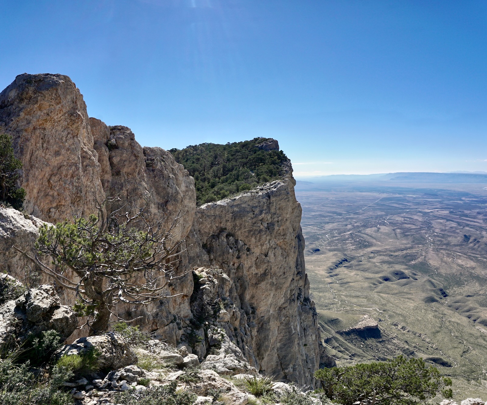
The north ridge of El Capitan offers a unique perspective on the southern slopes of Guadalupe Peak and its radical western escarpment. The uplifted reef extends from El Capitan to Guadalupe, Shumard, and Bartlett peaks, and Bush Mountain, the four tallest mountains in Texas. (Thomas Holt Ward, photo)

Travelers accustomed to seeing El Capitan from the highway might be surprised to learn climbers must drop 1,000 feet from the Guadalupe Peak Trail before scaling along the rim to the apex of the southern prow. (THW, photo)

Route: Guadalupe Peak is nearly due west from the Pine Spring Trailhead. Follow the Guadalupe Peak Trail as it snakes through complicated and rugged terrain. The footpath is well-trodden and easy to distinguish from secondary trails that spin off the main. The route to El Capitan (indicated with a blue line) leaves the peak trail 250 feet below the summit. The off-trail route is essentially a straight shot south (with nuances!).

Guadalupe Peak
Four trails leave from the Pine Spring Trailhead, elevation 5,840 feet: Guadalupe Peak, Devil's Hall, El Capitan (runs along the base of the peak), and The Bowl. There are three trail junctions in the first 0.8 mile. If in doubt, stay on the main path charging upward.

We started hiking in dawn light, the full moon settling down in the west. We carried uncertainties along with packs heavy with food, water, rain gear, and a headlamp. We weren't sure if we could navigate ourselves to El Capitan or how long the two-mountain hike would take. It was a warm morning and crazy beautiful. The awakening sun set the world glowing, the stony bedrock path sparkling. You will get a taste for the trail's challenge from the start. There are juniper log risers with hefty step-ups and crushed rock treads. Further along, risers are made from artfully set boulders and the treads are thin slabs of stone. Now and then boot-smoothed limestone rises to the surface and you'll imagine yourself walking on top of a reef. (THW, photo)


At 6,600 feet the trail turns northwest to commandeer the ultra steep slope. Trail builders chiseled and blasted their way up the pitch. Dynamite drill holes perforate the surface. I was both incredulous and grateful that this trail escorted us so effortlessly up an otherwise unscalable mountain.

There is one short section of trail that will give those with a fear of heights pause. It is just ahead of "Around the Bend" at 7,040 feet. It is posted in both directions with a sign: "Caution: cliff riders dismount and lead." Likewise, parents should have a tight rein (so to speak) on children. (THW, photo)

On the other hand, people who get off on safe-enough but slightly scary places will think this is the coolest part of the trek. The blown pathway is three feet wide with a substantial drop off to one side. (THW, photo)

The trail curves sharply around to the back side of the front hill at 1.6 miles. The grade eases, the steepest part of the hike accomplished. However, be psyched for more stair-stepping to come. Look carefully at the image below and you'll see the Tejas Trail climbing out of Pine Spring Canyon toward Hunter Peak, image-right.

Below, the full moon sets behind Shumard Peak, 8,615', ranked third highest in the state.

The path traverses a north-facing slope. It was a shady, cool passage in autumn and could well hold snow in winter. The woodland favored an array of trees typically found in the park: piñon pine, Chihuahua white pine, Douglas fir, alligator juniper, and Arizona pine, shown.

Guadalupe Peak comes into view when the trail turns west once again at 3.0 miles. Pass the backcountry campsite, descend slightly, and cross a wooden plank bridge. (THW, photo)

The bridge spans a fissure in the cliff wall.


The pathway heads Guadalupe Canyon, a rift in the reef plunging 3,000 feet in short order.

Begin ascending the east slope of Guadalupe Peak in lengthy, lazy switchbacks. Aside: The image below was taken from the east ridge and shows the notable and enticing bluff above the bridge. On our return we crossed the bridge and then walked up onto the bluff for an alternate view of the peak.

From the bluff, the peak displays a thin mantle of vegetation that's taken hold on solid limestone, the generous trail platform laboriously hacked into its flanks. (THW, photo)

In the switchbacks, the trail maintains a pleasant grade. Below, El Capitan is just coming into view. With every step the terminus of the Capitan Reef becomes ever more impressive. (THW, photo)
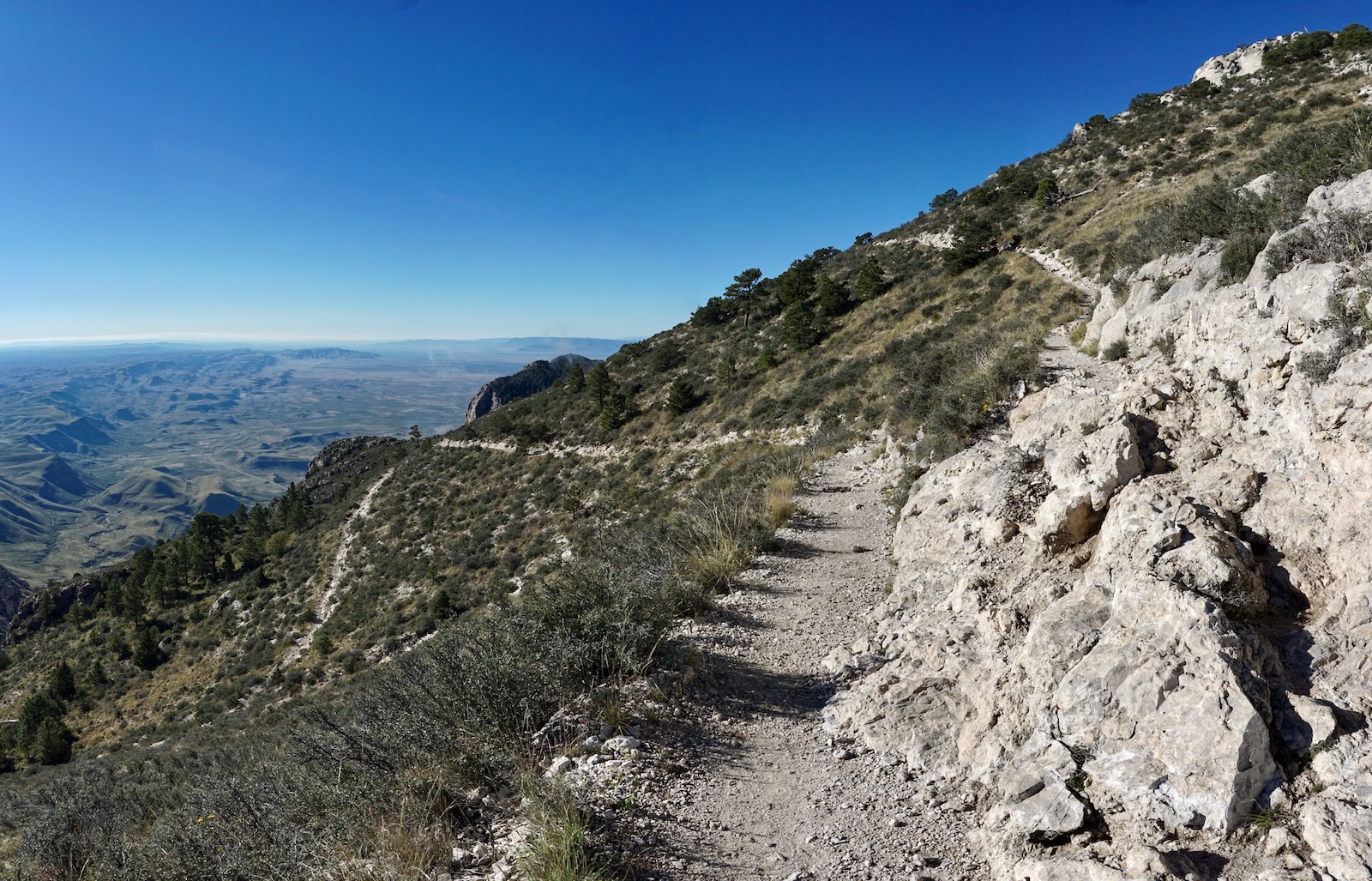
The spur to El Capitan leaves the Guadalupe Peak Trail at the apex of a switchback at 8,500 feet. I will discuss this option in detail later in this post. Meanwhile, one of my favorite sections of the peak trail awaits. The passageway is cleaved from weathered limestone with shiny crystals. The top of the reef is right beside the path, ten feet overhead.

Arrive on the summit of Guadalupe Peak at 4.25 miles. Congratulations, most especially to all the Texans who achieve their state's highpoint. With a rise of 3,027 feet off the 5,723-foot saddle (and 5,100 feet above Salt Basin), the uninterrupted vantage point is downright imponderable. The image below was shot from the west promontory and depicts the generous crest covered in "bubbles" of limestone. Based
on new, more accurate measurement technology, LiDAR, the mountain has been elevated over what is shown on the topo by one foot to 8,750 feet. (THW, photo)

The three-sided summit monument commemorates overland stage and air travel. It was installed in 1958 before the inception of the national park. (THW, composite photo)

This image looks north to Shumard and Bartlett peaks. It lends perspective on just how abruptly and vertically the Capitan Reef projects from the surrounding plain.

El Capitan
The off-trail trek to El Capitan (from elevation 8,500 feet on the Guadalupe Peak Trail) adds 1,450 feet and 2.4 miles roundtrip. While it took us three hours, your time might vary radically. For perspective on our pacing, our roundtrip time to Guadalupe Peak (including breaks) was just over five hours. Guadalupe Peak is a fine mountain and deeply satisfying. But for confident desert mountaineers, El Capitan is the greater pleasure. It has everything: navigation challenges, rough surfaces, light scrambling, insane views, and cliff walking.
I will describe our two routes, out and back. Both were perfectly acceptable. There's plenty of latitude, including spending more time roaming along the rim. El Capitan is essentially due south from the launch point and our out-going route proved the more efficient. I've roughly drawn it on the photo below. On the initial descent ridge, the first 100-foot pitch was the hardest. It begins steeply with loose rubble underfoot and impeding brush. A quick perusal of the web ahead of time warned repeatedly of heavy brush. Sure, wear long pants. Maybe we're hardened by off-trail cactus slashing in the Sonoran Desert because brush was a not an issue for us.

As we descended there was more bedrock, less brush, and better traction. Limestone karst is as sticky as rock gets. It literally digs its stony claws into your boots and wears them away. A mystery plant was wafting a sweet, rounded earthy perfume. I didn't know the earth could smell that good. We headed for "The Bowl," shown, where ridges and gullies coalesce. In fact, we entered a handy gully just before hitting the low point at 7,640 feet. From there, it worked superbly to climb to the rim, hitting it in the notch south of the triangular knob depicted. (This knob is just south of the 7,780-foot saddle giving El Capitan a rise of 305 feet.)

Don't get your momentum up. Gasp! It doesn't get more airy than standing on this threshold between stone and sky with its sheer 1,000-foot drop. (THW, photo)

We arrived on the raw edge at the very moment a low-flying fighter jet came through the breach while snapping an aileron roll. More drama!

The overhanging cliff profile is a no-nonsense freefall zone.

The wind was a contender and gusts complicated matters. So we were grateful to happen upon an unexpected game/social trail a comfortable distance off the rim. Even erratic and fragmentary trails are gratefully accepted. This image was shot looking south from the first false summit at 8,060 feet.

El Capitan wants to be climbed. We could have gotten cliffed out ten different ways. And yet, here we were just gliding up, our hearts filled with expectation and elation. This mountain is for all those people out there who relish big limestone walls. I was reminded of Notch Peak in Utah's House Range and Big Hatchet Peak in the New Mexico Bootheel. (THW, photo)
Trees part to reveal unadulterated sky and the climb abruptly ends on a perch looking out over measureless spans of visual space. We walked over to the aerie suspended over thin air, disturbing the local flyers who were surely questioning what a couple of humans were doing in their domain. (THW, photo)

It was emotionally gripping out there at the ragged edge of the world. I think mountains leave an imprint on our souls. Perhaps even more so when you stand atop a thousand-foot perpendicular limestone wall, sedimentary material splays for another couple of thousand feet, and Guadalupe Canyon dissipates into the Guadalupe Arroyo 4,000 feet below the reef.

Below, I'm heading back to the El Capitan summit from the aerie with Guadalupe Peak in the background. (THW, photo)

If you have any doubt about how to extract yourself from the El Capitan spur, simply retrace your steps to the trail (black-line route shown below). We wanted to check out a possible shortcut, so from The Bowl we started up our descent ridge and then transitioned to the ridge on our east at 7,760 feet. At 8,100 feet, we transfered once more to arrive on a flat at 8,160 feet (blue-line route).

We read about a shortcut on the web and it would have been a quick jump over to the trail, joining it at 8,200 feet. Perhaps it would have worked out fine but it looked treacherous to me. I'm not fond of sidehilling on steep slopes with loose material, shown. Plus, the gully crossing looked scary. So we just hefted up the ridge we were on. It proved to be an excellent route. We made contact with the Guadalupe Peak Trail at 7.0 miles and simply strolled back down the mountain.

This beguiling image of both El Capitan and the summit of Guadalupe Peak was shot through the windshield on the roll up Highway 54.

El Capitan is a monumental tribute to our ever-evolving Earth. Whether you admire it from Highway 62/180, the Guadalupe Peak Trail, or from the summit aerie, the southernmost tipoff on the Capitan Reef leaves a favorable and indelible mark.

1 comment:
This was a fantastic blog. I’m hoping I can successfully navigate from GP to El Capitan!
Post a Comment