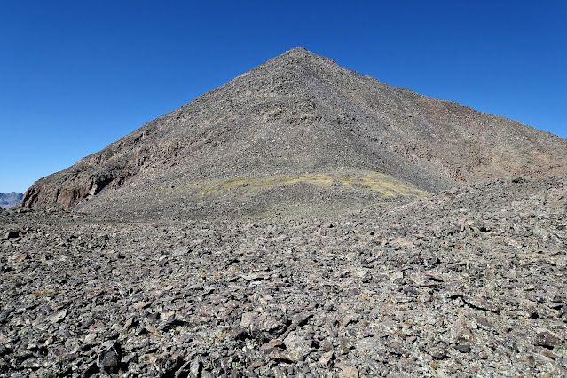
Essence: The Rio Grande Pyramid sits directly on the Great Divide. Its waters shed west to the Colorado River and east to its namesake waterway. The classical, four-sided polyhedron is seen from throughout the San Juan Mountains. Its call is undeniable. It is distinguished from other venerable bastions by its companion to the south, The Window. While the Pyramid holds the Earth down by its sheer structure and mass, The Window is an enormous gap in a volcanic ridge defined, in contrast, by emptiness and weightlessness. After years of looking from great distances at the Pyramid floating as a solitary sentinel and
gaping in wonder at The Window, I made the 23 mile trek in 2009 and again in 2024. I have super fit friends who have completed the journey in one long day. I prefer a three-day backpack, enabling a leisurely summit day and time to relish the varied terrain on one of Colorado's finest loop hikes. You may wish to climb other peaks in the vicinity. The Rio Grande Pyramid is Colorado's 97th highest summit. LiDAR has increased its elevation to 13,825' with a rise of 1,912 feet. The hike is within the Weminuche Wilderness, managed by the Rio Grande and San Juan national forests.
Travel: From Creede, proceed north on Co 149 past Freemon's General Store. Shortly past mile marker 41 and a scenic overlook, turn west on FSR 520, signed Rio Grande Reservoir. Descend into the oxbow-flat valley and cross the Rio Grande River. The 2WD gravel road is wide and graded. Turn left 10.8 miles from the highway, following a sign for Thirty Mile Campground and Weminuche Creek Trailhead. Cross the Rio and continue up the road to a large trailhead parking lot on the right. Water, pit toilets, no fees.
Thirty Mile Campground: The 35-site Forest Service campground is on the banks of the Rio Grande River, just downstream from the reservoir.
Distance and Elevation Gain: Total: 23 miles, 5,220 feet. Day 1: Trailhead to Weminuche Pass, 5.2 miles, 1,440 feet. Day 2: Loop to Rio Grande Pyramid and The Window, 12.4 miles, 3,640 feet. Day 3: Weminuche Pass to Trailhead, 5.2 miles, 140 feet gain.
Total Time: Trailhead to Weminuche Pass base camp 2:15 to 3:00. Loop to Rio Grande Pyramid and The Window 8:00 to 10:00.
Difficulty: Trail, off-trail; navigation moderate; Class 2+ scrambling on the summit pyramid; no exposure; extensive talus hopping; dress for some willow bashing.
Maps: Weminuche Pass; Rio Grande Pyramid, Colorado 7.5' USGS Quads
Latest Dates Hiked: September 12-14, 2024
Quote: The pyramid shape is said to hold many secrets and amazing properties. One of them is a sense of wonder. Vera Nazarian
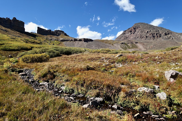
The Rio Grande Pyramid is seen frequently from the long approach on the Skyline/Opal Lake Trail. Students of geometry will appreciate The Window's perfect open square shape and its location due south of the Earth's pyramidal monument resting on, and celebrating, the Continental Divide. (Thomas Holt Ward, photo)

Route: This hike utilizes multiple very old trails whose names have been inconsistent over the years. Some trails (Rincon La Vaca, for example) have been superseded by the Continental Divide National Scenic Trail. To avoid confusion, I am using the current Forest Service names. The map below depicts the route for the Day One (and Day Three in reverse) backpack from Thirty Mile Trailhead. On the Weminuche Trail, track west along the Rio Grande Reservoir and then ascend southwest beside Weminuche Creek to the base camp on Weminuche Pass.
Route: This hike utilizes multiple very old trails whose names have been inconsistent over the years. Some trails (Rincon La Vaca, for example) have been superseded by the Continental Divide National Scenic Trail. To avoid confusion, I am using the current Forest Service names. The map below depicts the route for the Day One (and Day Three in reverse) backpack from Thirty Mile Trailhead. On the Weminuche Trail, track west along the Rio Grande Reservoir and then ascend southwest beside Weminuche Creek to the base camp on Weminuche Pass.

For the loop to Rio Grande Pyramid and The Window, from base camp hike west on the Skyline/Opal Lake Trail for roughly four miles. This trail is unmaintained and requires some savvy to stay on course. Leave the trail and ascend north on a social trail to elevation 12,600 feet near Saddle 12,645'. Swing west and pitch steeply up a use trail to the "High Saddle" at 13,100 feet. Scramble on talus up the summit pyramid. For The Window (off-trail), return to the High Saddle and descend a southeast ridge briefly and then cut southwest to The Window. To complete the loop, descend southeast toward "Window Lake" and pick up the Continental Divide Trail. Follow it east to the Pine River Trail and hike northeast back to the Weminuche Pass base camp.

Day One: Thirty Mile Trailhead to Weminuche Pass Base Camp
Locate the trail register at Thirty Mile Trailhead, elevation 9,340 feet. From there, Weminuche Trail #818 (aka Weminuche Creek and Weminuche Pass trails) heads southwest. This vigorously maintained trail is a popular link with the Continental Divide National Scenic Trail. In hunting season, we saw numerous strings of pack mules, horses, cowboys, and hunters hoofing it over to the west side of the Divide. Wear blaze orange in autumn.

The trail runs up the power line for the dam operated by the San Luis Valley Irrigation District. At 0.6 mile, the trail passes on the south side of the earthen dam and spillway.

Enter the Weminuche Wilderness, the largest wilderness area in Colorado spanning 499,771 acres across the San Juan and Rio Grande national forests. The name derives from the historic Weeminuche band of the Ute Mountain Ute Tribe. It had been a wet summer in the San Juan Mountains and boulders framing the old dirt trail were covered with thick moss and lichen. We crossed a frolicking creek at 1.0 mile. Fluttering aspen and young conifers created dappled and lively shade. A gradual ascent begins and the trail turns abruptly into the Weminuche Creek drainageway at 1.8 miles. The well-engineered trail makes a smooth passage over a big block boulder field. The erosional and weathering forces associated with these massive boulders are a sample of what's to come. At 2.0 miles, 9,900 feet, a sturdy plank bridge spans the constricted canyon. It replaces the rickety bridge I crossed a few years back.

Colorful aspen bordering this meadow announced the arrival of autumn.

Three miles in, the path skims alongside the ultra large Weminuche Creek meadow and wetlands. From there, the gradient slacks and the trail gains only 300 feet in the next two miles. Look clear across the cinquefoil-studded grasslands to the pass. Watch for moose foraging among the willows and elk on higher ground.

Cross a couple of creeks. Most likely these will be easy enough to hop across. However, the third crossing at 5.2 miles is draining a large watershed and might pose more of a challenge. Just past the creek is a large open area that serves as the base camp for this hike. There are plenty of both open and secluded camp sites. It is wise to sleep out of the fall line of the standing dead conifers. Weminuche Pass is the lowest point on the Continental Divide in the Weminuche Wilderness, elevation 10,640 feet. West of the pass are the headwaters of the Los Pinos River, a major tributary of the San Juan River, and ultimately, the Colorado River.
In September of 2024, the wildflowers had gone to seed. On previous hikes in this area, some unusual flowers were spotted including pink wintergreen, wood nymph, chainpod, penstemon glaber var. alpinus, and a pink penstemon at The Window.
Day Two: Rio Grande Pyramid and The Window
This 12.4 mile loop can be hiked in either direction. I have twice hiked it counterclockwise and that is how this description is presented. Strong hikers can reasonably add Peak 13,287' (LiDAR 13,290', "Fools Pyramid") and unranked Window Peak (LiDAR 13,158', rise 285 feet). The unmaintained Skyline/Opal Lake Trail #714, leaves the Weminuche Trail on the pass and bears north. A couple of big cairns mark this junction, seen below, and the trail soon materializes in the grass. In 2009, the trail was elusive and functioned more as a route. By 2024, the footpath had seen more traffic and was easier to follow. The existing trail doesn't track with the "Skyline Trail" shown on the Weminuche Pass topo for the first 3.0 miles. There is a fair amount of deadfall from beetle kill that has ravaged this forest. There are informal workarounds for snarled logs that can't easily be stepped over.

The trail ascends on the Continental Divide for the first mile and then parallels the Divide on the south. It soon climbs more aggressively, the thin track dug into the side of the slope. At 1.5 miles, the path levels out on the 11,800-foot contour. The grade from here to the "Peak Trail" is imperceptible. Hikers are rewarded with their first view of The Window and the Pyramid.

At 1.8 miles, the trail is obscured by downed timber, just as it was in 2009. The trail comes and goes. There is very little undulation through this passage. Use your trail intuition. If you lose the trail, go back and find it or, as my partner frankly said, "you are done."

At 2.1 miles, cross beneath an impressive band of talus that tumbled off the Divide. Bucolic Rincon la Vaca with our homebound trail is on the south enclosed by Point 12,497' and Peak 12,724'. (THW, photo)

At 12,000 feet reach tree limit. The trail is eroding away on a steep slope. Heed your footing--self-arrest would be difficult.

At 2.7 miles we arrived within a community of massive boulders. Volcanic towers clung desperately to the steep slope below Point 12,808'. We took a break here and attempted to assimilate this profound landscape. This is one of my top favorite places on the loop. (THW, photo)

We wallowed through some sizeable patches of unclipped willows. It is especially helpful to stay on trail here.

The pathway curves with the landscape to the southwest. Looking at the image below, the Peak Trail leaves the Skyline/Opal Lake Trail just above the white patch of earth. Follow it north up toward the saddle platform at 12,645'. Above that, it's a thin, red thread pitching up to the "High Saddle."

Leave the Skyline/Opal Lake Trail at 3.9 miles, 12,320 feet. A couple of cairns mark this location. On some editions of the Rio Grande Pyramid quad, the Skyline Trail continues south and southwest to end at what is informally called "Window Lake." Since the location of Opal Lake is not shown on the map, perhaps it's the proper name for Window Lake? At any rate, the trail is barely perceptible beyond the Peak Trail junction.

The approach is over with 1,500 feet to climb over the next mile. Ascend north on the steep, crushed rock social trail to 12,600 feet, south of Saddle 12,645'.

Turn 90 degrees west and enjoy the reprieve walking off-trail on flat talus.

Aim for a large stacked cairn. The use trail materializes beside a field of boulders. (THW, photo)

There are two ultra steep pitches that lift the hiker to the High Saddle. The first begins at 12,700 feet, plows through deep gravel, and eases at 12,860 feet.

On the next pitch at 12,900 feet, the trail was too slick to stick. We found it easier to flank the trail in the rubble.
(THW, photo)

Arrive on the High Saddle at 13,100 feet, just west of Point 13,185'. (Note, this is where we bailed off the east ridge for our route to The Window.) I thought for sure we were looking at the apex of the Pyramid but indeed, it is a false summit. In 2009, our little group had "exhausting weather" for three days. We hunkered down on the High Saddle waiting for a snow storm to blow over and for lightning to dissipate. In 2024, we insisted on a three-day, severe clear weather window. Notice the gas bubbles on the surface of the boulders. The Pyramid is a stratovolcano, also known as a composite volcano, built up by many layers of hardened lava and ash. It is composed of basalt and andesite, extrusive volcanic rocks.
There is no defined trail up the summit pyramid, though you may happen upon some fragments. To begin, the medium size talus is fractured and somewhat loose.

At 13,400 feet, we got into bigger, stable rock with fun Class 2+ scrambling.

The journey to the Rio Grande Pyramid is a commitment and I slowed down to savor every footstep, every stone, every moment. I simply wanted to be with this regal mountain. Flowing out behind me to the northeast is Fools Pyramid and Simpson Mountain. (THW, photo)
The journey to the Rio Grande Pyramid is a commitment and I slowed down to savor every footstep, every stone, every moment. I simply wanted to be with this regal mountain. Flowing out behind me to the northeast is Fools Pyramid and Simpson Mountain. (THW, photo)
Topping out on most any mountain is a highly anticipated and revelatory moment.

Arrive on the surprisingly roomy apex at 4.9 miles. The Pyramid is an isolated guardian surrounded by meadowlands in the immediate vicinity and the full spectrum of the San Juan Mountains. I felt both euphoric and incredulous.
(THW, photo)

Most startling was the view west across the great valleys of Ute Creek to the granitic Needle Mountains and the quartzite arc of the Grenadier Range.

The Window
We were fortunate to have the weather for plenty of top time on the Pyramid. This description returns to camp by way of The Window, not to be missed. The Pyramid and The Window are an odd, but complimentary geometric pair. As an aside, please don't be tempted by our 2009 shortcut route to The Window. It looks good on the map but is unsafe on the ground. We started down the west face for a short distance and then dove south down the "Surf Couloir." The rock is on the angle of repose and when I stepped on a slab, the mountain and I started sliding down together. I rode that slab for 100s of feet, big boulders, scree, and me all moving along together. It was a fast trip down alright but terrifying. The couloir deposited us on the Continental Divide and we walked south on "Window Ridge" and came through The Window from the west.
What follows is our recommended route to The Window which we have perfected over a couple of trips. First, when leaving the summit be sure you are descending on the east ridge, your upcoming route. It would be very easy to start down the northeast ridge by mistake. I found the descent to the High Saddle easy-going and comfortable on stable rock. If you cut south too soon from the saddle, you will be snarled in cliffs and ugly, steep, tedious and slippery hard pan. (It's been tried!) Instead, in front of Point 13,185', descend on the southeast facing ridge, image-center-right.

Stroll out the southeast ridge a short distance.

The route is clear from there. In this image, the Pyramid is on the right and The Window is in front of Window Peak, image-left. (THW, photo)

Get a free ride down by plunge-stepping to 13,000 feet then swing southwest and cross the tundra patch.

Talus traverses are unavoidable.

Cross an extensive and final bowl of tundra.

As you draw close to The Window, look up to the skyline to see toadstool rocks balancing on the Continental Divide.

As The Window opens, it is simply magical.

Hug the cliff, a beautiful volcanic breccia wall. (THW, photo)

The Window is massive. No wonder it is visible from all over the San Juans. It's an unusual earth monument--empty space. Many people assume The Window is a gap in a volcanic dike but it could well be an erosional remnant. The pointed block in the center of the gap is a superb example of breccia--small boulders and rubble cemented together in a matrix.

The walls are perfectly vertical. Look on the south wall for the historic inscription,"STEWART GAP." (THW, photo)

The image below depicts our incoming route to the right of the north wall and our 2009 route on the left. (THW, photo)

Exit on a trenched social trail located by the breccia boulder. The trail bears southeast taking aim on Window Lake. Great chunks of stone that have tumbled out of The Window are strewn on the slope.

The Window is enormous!

Fair weather clouds highlighted The Window, Pyramid's odd but eternal companion.
The trail disappeared in the tundra and we were trapped by some serious willow bashing. Simply aim for the lake. Just north of the lake at 7.0 miles, we turned northeast on the Continental Divide National Scenic Trail #813 (CDT). The CDT shares tracks here with the rerouted Rincon La Vaca Trail, now simply called the CDT. The cross-continent trail was marked with tall sticks in rock cairns and the trail was covered in shod horse tracks. It was hunting season after all.

At 7.8 miles the almost indecipherable Skyline/Opal Lake Trail joins the CDT at an unmarked junction. The CDT soon takes a dive off the flat and cruises down into Rincon La Vaca. The trail is effectively paralleling the incoming route on this classic loop. (THW, photo)

Cross the vigorous north tributary of Rincon la Vaca at 8.2 miles. The trail makes a 90 degree turn and marches south with well-engineered switchbacks. The verdant, cascading stream and moss-covered boulders contrast sharply with block fields on the east. (THW, photo)

The Rio Grande Pyramid is a Colorado Centennial and yet each time I've visited the mountain, I've seen but one other person. The Pyramid is so deeply embedded in the Weminuche Wilderness, total silence and solitude is likely. The one person we saw on this day was a man hiking to the very west end of Rincon la Vaca for the first day of muzzleloader season.

I would encourage everyone who climbs the Pyramid to commit to hiking the loop. The series of trails pass through ridiculously wild landscapes. Below, the river of gigantic boulders has the same dynamic feel I associate with avalanche paths and landslides.

The CDT crosses wetlands with ultra clear water, passes by a reflection pool, and at 10.0 miles arrives on the floor of Rincon La Vaca. We walked by three horses grazing beside lazy oxbows and a silent hunter's camp. At 10.9 miles, the CDT hooks sharply to the right. Stay straight to connect with the Pine River Trail. The path heads upstream in the infinite Los Pinos River Valley. The Pine River Trail #523 comes in from the right at 11.3 miles. This is the final trail segment for this route--keep it pointed northeast. (THW, photo)

We could see the pass from far away and only inches higher than where we were right then at the close of this wondrous day.

Day Three: Return to Trailhead
Figure 2:30 back to the trailhead or less. It's a fast downhill with minimal gain. During the long days of summer, strong hikers could conceivably pack up and book it back to the trailhead after completing the loop.
3 comments:
December 24, 2024
Debra and Tomas,
Your description and photos of your backpack, hike, and climb of the Rio Grande Pyramid and The Window is a gift. The Weminuche Wilderness is a backyard hero for hikers, climbers, and packers in the Four-Corners area, as is your blog, Earthline: The American West. Outdoor aficionados around the compass lean into your writing and photographs for illuminating expertise to plan their treks.
Debra and Tomas, your canon of work and generosity is boundless. It stretches across the West in rhythm, speed, pace, time, season, challenge, and topography. You note in your writing of the Pyramid and Window that they are icons of the Weminuche and visible throughout the San Juans. Yet, you’ve seen but one other person each time you’ve made the pilgrimage to that revered panorama. That’s another reason roamers, ramblers, and wanderers tap into your blog.
You’ve mentioned that you hope your blog inspires a love and reverence for this sweet wild world. Hell yes it does!
So, here’s to you Debra and Tomas. Thank you. g
g, Thank you for expressing your deep appreciation for Earthline. The Rio Grande Pyramid was a high priority in 2024, in part because I wanted to share it with Earthline readers. I needed a track, photos, and impressions. Your comments on this particular post are most welcome. Tomas provides technical support for this blog. Plus, he drives to sketchy trailheads and is my hiking companion. Earthline wouldn't exist without him. Debra
One more thing! Tomas is the accomplished photographer. My pictures are utilitarian; they simply document the route. Debra
Post a Comment