Essence: The Vulture Mountains are an unconsolidated array of peaks splayed out over a large area south of the historic town of Wickenburg and west of the Hassayampa River in northwestern Maricopa County. Vulture Peak is the tallest mountain in the range with a rise of 1,190 feet. Its radical profile is so distinctive and such a source of pride for townsfolk, its likeness is splayed on everything from T-shirts to beer cans. Vulture is a half-day hike on an impeccably engineered trail to its south saddle. From there, the remaining 0.1 mile up the summit block is a route, not a trail. It is suitable for hikers with moderate scrambling skills. There are plenty of solid holds. The peak register on the linear summit ridge was stuffed. It is not a hike of solitude to the Vulture Benchmark. But it is great fun. Descending hikers we ran into were downright gleeful. The hike is on land administered by the Bureau of Land Management.
Travel: The Vulture Peak Lower Trailhead was temporarily closed for construction in February of 2025. The Vulture Mountains Recreation Area is managed by Maricopa County Parks and Recreation. Follow the link for current status. To locate the temporary trailhead, toward the west side of Wickenburg on AZ 60 (also Wickenburg Way), turn south on Vulture Mine Road. In about six miles, cross Syndicate Wash and start watching for the parking lot on the east side of the two-lane. It is located at mile marker 20. The dirt lot has room for about 15 cars. No signs, no facilities. The Vulture Peak Upper Trailhead (see map) is 4WD accessible. Note: Vulture City Ghost Town is a few miles further south on Vulture Mine Road.
Distance and Elevation Gain: From temporary parking, 5.4 miles; 1,450 feet.
Total Time: 3:00 to 4:30
Difficulty: 4WD track, trail, route; navigation easy; Low Class 3 with mild exposure above the saddle; carry all the water you will need and hike on a cool day.
Map: Vulture Peak, AZ 7.5' USGS Quad
Date Hiked: February 8, 2025
Total Time: 3:00 to 4:30
Difficulty: 4WD track, trail, route; navigation easy; Low Class 3 with mild exposure above the saddle; carry all the water you will need and hike on a cool day.
Map: Vulture Peak, AZ 7.5' USGS Quad
Date Hiked: February 8, 2025
History: According to Will C. Barnes (Arizona Place Names, The University of Arizona Press, 1988), the peak was named by Henry Wickenburg. In 1863, while
prospecting for gold, he saw buzzards hovering over the peak. The birds were likely the common turkey
buzzards, often called vultures. Wickenburg's gold mine was highly successful yielding more than $30 million worth of gold.
Quote: Vultures are the most righteous of birds: they do not attack even the smallest living creature. Plutarch
The summit of Vulture Peak is a solid block of volcanic stone. The ridge extending south is interrupted by deep gashes creating a lineup of towers and blocks.
Route: From temporary parking, walk south on BLM 9056 for one mile. Transition onto the Vulture Peak Trail which bears northeast and then east until it butts up against the west wall of the peak. Mount steeply up a break in the cliffs and arrive on the saddle south of the peak. Scramble north to the summit. Return as you came or take a shortcut on a 4WD track to Syndicate Wash. Walk north in the wash back to BLM 9056.
Route: From temporary parking, walk south on BLM 9056 for one mile. Transition onto the Vulture Peak Trail which bears northeast and then east until it butts up against the west wall of the peak. Mount steeply up a break in the cliffs and arrive on the saddle south of the peak. Scramble north to the summit. Return as you came or take a shortcut on a 4WD track to Syndicate Wash. Walk north in the wash back to BLM 9056.

Driving south from Wickenburg on Vulture Mine Road, the three-pronged solitary sentinel looks rather daunting. (Thomas Holt Ward, photo)

This image looks north from temporary parking and BLM's rerouted trailhead.

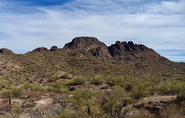
Seen from parking, elevation 2,580 feet, the near-black mono hue of Vulture Peak contrasts with Sonoran-green saguaro, paloverde, and creosote.
Be aware that there are no signs in the vicinity of the temporary trailhead. This was a little disconcerting until we ran into some hikers who knew the drill. The simplest instruction for reaching the Vulture Peak Trail is to walk south on BLM 9056 for exactly one mile.

Cross Syndicate Wash at 0.2 mile. Stay on BLM 9056 when 9056A goes off to the left. Cross the wash again in short order. On our way to the mountain we stayed on the road above and paralleling the wash. On our return we opted to walk in the dry drainageway.

There was teddybear cholla insanity on both sides of the road. It was the thickest and richest stand of teddybear I've ever seen with the exception of the summit dome on relatively nearby Woolsey Peak. (THW, photo)

At 0.9 mile, BLM 9056 intersects the Vulture Mine Trail that originates at the Lower Trailhead, 0.2 mile to the west. If the numbers check out, the hike will be 1.4 miles shorter when the Lower Trailhead opens. Also at this location, BLM 32932 heads off to the Upper Trailhead. Stay straight on BLM 9056.

At 1.0 mile, leave the wash, step over a steel barrier and onto a singletrack. Again, there were no signs, but this is the Vulture Peak Trail.

The footpath swings around to the northeast. Walking is smooth and easy. Big rock piles define the trail and lines of stones block braids. The Sonoran has endured a years-long drought. We didn't see even one blooming flower. Pricklypear was paper thin. When the rains return, claret cup cactus and ocotillo will electrify the landscape.

The treadway is ultra sweet. Hillocks are threaded one after another with undulations and sinuous switchbacks.
(THW, photo)

At 2.1 miles the trail descended into a wash and a road coming in from the west crossed our path. A faded carsonite sign suggested the trail continued straight ahead. However, the trail has fallen into disuse. So turn east on the 4WD track, the road to the Upper Trailhead.

Arrive at the Upper Trailhead and parking platform at 2.2 miles, 2,640 feet.

The generous trail has stone water bars and volcanic rubble. Looking toward the incredibly appealing mountain the path ascending the west slope is invisible.

At 2.5 miles, 2,900 feet, the trail turns and makes for the saddle south of the peak. When we were up against the west wall we could feel the power and presence of stone. (THW, photo)

Enter the break that leads to the saddle at 3,200 feet. The masterfully constructed trail has switchbacks and big-block risers.

A jug handle arch is high on the south wall. (THW, photo)

Arrive in the saddle at 2.9 miles, 3,420 feet. It is a large opening with great sitting rocks. When we arrived there were six people relaxing, only one made the peak. It takes about 15 minutes to top out on Vulture from there. Conceivably, reluctant hikers could wait while others in the group did the scramble. This image looks at the broken south ridge.
(THW, photo)

Point 3,128' makes a final commanding statement in the Vulture Mountains. To the southeast the White Tank Mountains are on the western outskirts of greater Phoenix. (THW, photo)

Scott Surgent (The Arizona Mountains Gazetteer) calls Vulture Peak an "Arizona classic." It wasn't even on my radar until some hiking buddies from Colorado said it was a blast. So true! Looking north from the saddle, the scramble is in the wide crack against the wall on the left. Climb about 240 vertical feet over 0.1 mile to the summit. (THW, photo)


Be sure you can get down what you go up. If you are in doubt, call it and return to the saddle.

Sticky shoes really help on steep friction pitches. Notice the bedrock has little nibs for fingers and toes. If you need to, pretend you are a spider and use all your appendages. (THW, photo)

For fun, we climbed the final, solid Class 3 crack as we approached the top.

If you don't like the look of the crack, you can bypass it on the east where the terrain mellows out.

Top out on the summit at 3.0 miles. The crest is one massive block of stone covered in iridescent lime-green lichen. The peak register is in an A-box east of the summit. If you ascend on
the crack bypass you will run right into it. Two thick notebooks were completely filled. We are rarely on a mountain so popular. It makes total sense--close enough to a megalopolis, half-day hike, great views, and a little thrill thrown into the mix. (THW, photo)

The Vulture Benchmark was placed in 1948. Walk around in the vicinity and you'll find two additional disks--Reference Marks No. 1 and No. 3. (THW, photo)

It's just a stroll to the north end of the summit ridge where you can look out over Wickenburg, the Weaver Mountains, and the Bradshaw Mountains to the northeast.

This image looks back on the Vulture Benchmark.

The summit is both long and broad. We played all over, walking on ribs of stone.

This image shows the descent options. The bypass is image-left and the crack is just off-image on the right.

Below, my partner is downclimbing the Class 3 crack. The holds are spectacular. If you love that feeling of lowering yourself using all four points, this playful series is for you.

This image was shot after the two routes came back together.

Looking down on the approaching saddle, I could see a possible route to the first block on the south ridge. I'm sorry that didn't register at the time because it looks super appealing.

Returning, pass by the Upper Trailhead and then watch for the junction of the road and upcoming trail in the wash at 4.1 miles. The trail was charming but if you'd like to take the shortcut shown on the map above simply stay on the 4WD track. At 4.7 miles, we dropped into Syndicate Wash on a cairned trail. The surface was spongy sand and gravel but we appreciated the natural environment. In this image notice the metavolcanic gneiss on the wash floor. It is a different composition from the basalt and andesite stone found on the mountain proper. Transition out of the wash and back onto BLM 9056 shortly before the temporary trailhead. (THW, photo)

No comments:
Post a Comment