Travel: From Durango, drive north on US 550 for 28 miles to Durango Mountain Resort. At mile marker 49, turn left. Zero-out your trip meter and advance up the paved, ski area road. At 0.3 mile, turn right on Hermosa Park Road, #578. There is a small, brown sign marking this dirt road. A washboard-worthy 2WD should be able to reach the TH. The road, graced by aspens, makes three big switchbacks. Little spurs head off; the main road is obvious. At 3.2 miles, go right, staying on Hermosa Creek Road. At 3.6 miles turn right on Relay Creek Road, #579. Stay straight at 4.8 miles as Cascade Divide Road goes off on the right. (It serves the Pando Creek approach to Greysill.) Continue your passage on #580, contouring through aspens with occasional views of the day's quest and the Hermosa Creek Valley way down below. The East Fork of Sig Creek passes under the road through a culvert. Travel under Pt 12,007'. Park at 11.0 miles in a very large lot on the right. Allow 1:00 from Durango.
Distance and Elevation Gain: 8.4 miles, 2,900 feet of climbing
Time: 5:30 to 7:00
Difficulty: Abandoned road, off-trail; navigation considerable; mild exposure on The Divide and on Pt 12,007'; significant portion of route is on talus
Maps: Hermosa Peak; Engineer Mountain, Colorado 7.5 Quads
Date Hiked: September 13, 2014
Quote: Is a mountain only a huge stone? Is a planet an enormous mountain? Stanislaw Lem, Solaris
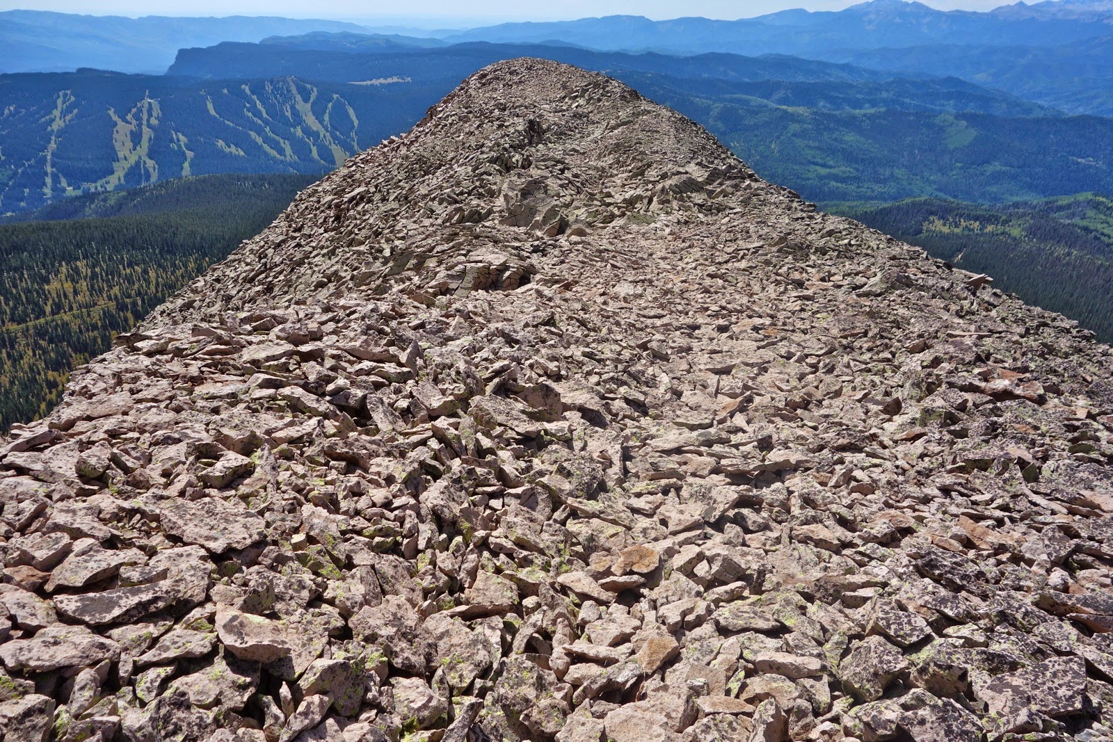
Grayrock Peak, left, and Graysill Mountain as seen from the ridge south of Jura Knob. Cascade Creek is down in the trench.

Route: Two standard routes service Grayrock Peak, the one described and Pando Creek. The mountain is immense. Use the Pando access to see Graysill's east side and to explore to the north. Our stem and loop route lends itself to roaming along the southern points. Approached from the southwest, the semi-flat mountain feels even more like a world unto itself. Begin on an abandoned road before surrendering to a day in the talus, broken infrequently by patches of tundra.

Trailhead 10,400' is marked by two road-blocking boulders down off the north side of the parking lot, hidden at left. This image looks back on the incoming road.

Go north on the moss and grass covered track with little evidence of use as it passes through an unhealthy fir forest. Follow the road intuitively and you will stay left at 0.3 mile and again at 0.5. At 0.7 mile, cross a rivulet. At 0.8 mile take the right fork.
Climbing gradually, the road becomes over-grown and indistinct as it nears a clearing below two points. "The Triangle" (as it appears on the 7.5 topo map), will loom to the east.

Point 11,663', pictured, a rounded form with patches of trees, is north. At 1.3 miles, 10,900 feet, stand in the heart of the clearing (N37 40.479 W107 53.360). It is a peaceful place of solitude. Imagine where Saddle 11,550' will be (center of image below), the next goal. Wend a course through small openings, stumbling on intermittent social and game trails. Cross an old road.

Find the golden path between the base of Point 11,663' and the forest. This couldn't be a sweeter lift to Saddle 11,550' at 1.9 mile.

At the saddle, a new world opens with Hermosa Peak shown, center left, and Lizard Head on the right. The saddle is disorienting with the land dropping decidedly off to the north. Where's the mountain? Turn right/east, rising gently in the woods. Clamor over deadfall for a brief time.

Hold a direct east bearing while ascending to 11,800'. At 2.4 miles emerge on tundra (embrace it!) in the krummholz. The mountain is on the horizon laying low like a gray whale. Continue walking due east, aiming for the base of the ridge.

There are startling views southwest to the La Plata range, the three mile knife of Lewis Mountain, visible. The image below features Point 12,007', to be scaled later in the hike.

At 2.7 miles, 12,120 feet, reach the eastern edge of Graysill; the Cascade Creek drainage lies below. This is where the Pando Creek access joins our route. Turn south and begin a talus ascent on a rounded ridge; soon it becomes more distinct. Reach an overview at 2.9 miles, Point 12,380 feet. From here you can see the thin Divide leading to Grayrock Peak. Below, Engineer Mountain lies close by to the east. Grayrock's prominent rock glacier spills off the mountain.

In the image below, the highest point on the horizon is Grizzly Peak and to the left of it is Sliderock Ridge. Pando Creek is in the foreground.

The Divide is one of the greatest features of this hike. The thin line straddles the Hermosa Creek drainage to the southwest and Cascade Creek drainage to the northeast, both, massive water carriers.

The Divide is a place of great drama, but exposure is not a factor for most people. It narrows to eight feet wide. Walk across on teetering plates.

As the ridge melds into Grayrock, the grade increases briefly. Near the top a social trail skirts right of jumbled rocks on the ridgeline. The ridge ends abruptly on an exceedingly broad, tundra covered, almost flat summit that goes on and on.

The register is located in a rock pile east of a major bivouac at 3.6 miles. (The register was gone in 2019.) For those familiar with these mountains, the crest is at the center of the known world. Spin 360 degrees. This is the middle ground between the La Plata and San Juan ranges. See the grand sweep of the Colorado Trail connecting the two. Blackhawk Mountain is the big hulk nearby to the northwest. Skiers at Purgatory see Grayrock all day long; now you know why.

Many people climb mountains simply to reach the summit. The quickest return is to retrace your steps to the trailhead. However, if the weather is good and you wish a better understanding of this landscape, continue on the loop. And while it is admittedly a gray world, the exploring is bright and cheerful. So, from the summit, walk south to Point 12,440'. This is straightforward and fun.
Look west to locate the second southern point, shown at the far left in this image. Return to the crest and walk back across The Divide on trickster, teeteree totteree talus.

Past the Divide, go southwest across this forever landscape to the very southern edge of the massive platform at 4.9 miles, 12,280 feet. The talus in this area was laid by a more competent stone mason and is rather accommodating to the walker.

From the second southern point, go west and work down a steep but manageable slope, aiming for the base of the Point 12,007' ridge, shown. Turn south and climb a small knoll. The boulders on the other side will wreak havoc with your sense of balance. Climb the ridge to Point 12,007'. It steepens and narrows the higher you get. Rocks are loose. There is mild exposure so if that's not your thing, take a pass on this optional spur to the third southern point.

Reach the top at 5.6 miles. The six foot cairn identifies Point 12,007' from afar. This image looks back on Point 12,440' and Point 12,280'. Return from this out-and-back at 5.9 miles.

The final southern point is The Triangle, 11,840 feet, a small, worthy diversion. The way is clear.

Plot the homeward course from here. Look down on the clearing at the end of the road from this vantage point. You could conceivably return by way of Saddle 11,550'. We contoured northeast 0.2 mile and then down a gradual slope on a slight bench another 0.2 mile to the trees. Relaxing on the grass at 6.5 miles, my hiking partner said, There's not a soul anywhere out here except for us, the birds, the wind in trees.

To reach the clearing, drop southwest 0.4 mile to a faint roadbed. Go right for 0.2 mile to the incoming track. Go left, reaching to the clearing once again at 7.1 miles. Follow the road back to the trailhead. Returning on the Relay Creek Road, puzzling Graysill will make more sense. Point 12,007' is left, Point 12,280' center, and Point 12,440', right.

2 comments:
Really enjoyed this write up!
Fabulous; I am happy it is useful. Thank you so much. Debra
Post a Comment