Travel: From Silverton drive north on US 550 toward Ouray. Pass under power lines and turn west on the Ophir Pass Road, San Juan CR 8, 4.7 miles from Silverton. Go steeply downhill and cross Mineral Creek. The track makes its first sharp hairpin to the right three miles from the highway. Pass by the parking area and sign for the OPUS Hut. Park on the right side of the road in a pullout with room enough for two vehicles, 4.0 miles from US 550. From here you can just about see the top of Ophir Pass which is 0.2 mile west. While 4WD is recommended, 2WD vehicles with good clearance and sturdy tires should be able to make the trailhead. Note: 4WD, HC required for the west side of Ophir Pass.
Distance and Elevation Gain: Lookout Peak roundtrip is 2.5 miles with 2,000 feet of vertical. For
Crystal Lake, add one mile, 400 feet of climbing, and one hour.
Total time for the peak: 3:00 to 4:30
Difficulty: Off-trail; navigation moderate; Class 3 with considerable exposure and poor holds.
Map: Ophir, Colorado 7.5' USGS Quad or Apogee Mapping
Latest Date Hiked: August 11, 2018
Reference: Colorado Scrambles: Climbs beyond the beaten path, by Dave Cooper, Colorado Mountain Club, 2009.
Poem:
Tell me, what is it you plan to do
with your one wild and precious life?
Mary Oliver, The Summer Day
The Crystal Lake Trail affords an analysis of the standard south ridge route up Lookout Peak.

Route: From the trailhead follow a cairned route north into the basin south of the peak. Ascend west on a vegetated slope to the south ridge. At the summit block either take the standard route up the south face or, bypass on the west slope using a ledge and crack system. After the climb, consider hiking to Crystal Lake, depicted with the black line.

The route begins from the Ophir Pass Road at elevation 11,700 feet. From the parking area the pass is just around the corner.

South Ridge
Locate a subtle path leaving from the pullout and plow through 15 feet of head-tall willows. Break out on a climber's trail bearing north up a shallow drainage east of Point 12,187'. The first objective is the always visible south ridge, best gained via a vegetated slope. In 2011, we were on our own in this rolling and somewhat convoluted landscape. Since then, Bob, the proprietor of OPUS Hut has set and maintained plentiful cairns.
Pass under power lines and avoid the trail branching west toward a pond. If you lost the faint path or cairns along the way simply head north-northwest, threading together tundra patches where possible. The route skirts west of a sizable blockfield, cuts west again on a rock shelf under a moraine, and climbs the east side of a chipped orange hill.

Enormous cliff blocks severed from their moorings and ground to a halt in the upper basin.

Amid the boulders my climbing partner spotted four rock ptarmigans. How many thousands of these seasonally camouflaged birds have I failed to see? (THW, photo)

Cairns lead onto a steep slope, a mix of vegetation, scree, and dirt. It is clearly the most reasonable course to the ridge.

Gain the south ridge of Lookout at 0.8 mile, about 12,760 feet. I've climbed Lookout twice. This image was shot in October, 2011. It captures the Ophir Pass Road, Crystal Lake, South Lookout, US Grant, and V3 after an autumn snowstorm.

From here the summit is 0.4 mile off with 900 feet to put away. In 2011, my field notes claim the climb was fun and playful but in 2018, it required a fair amount of mental discipline to summit. I tackled one segment at a time so that is how I will present it.
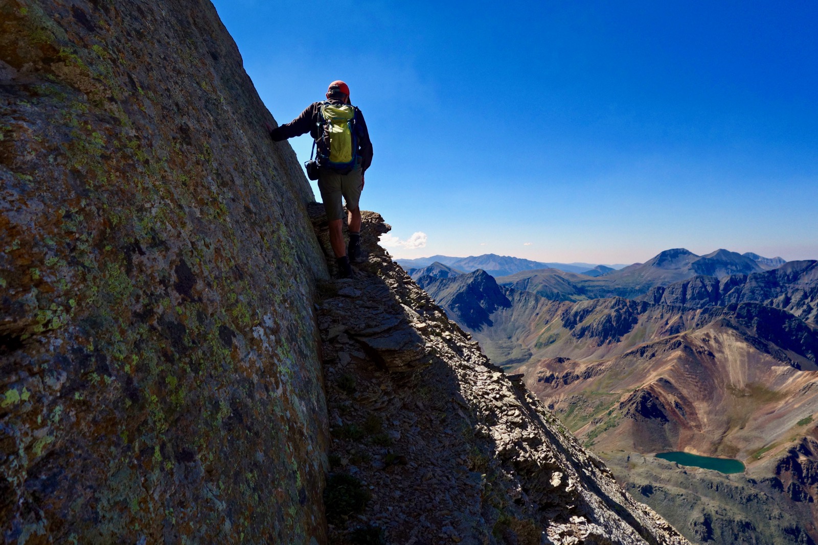
Puzzle Ridge
The ridge is troubled with gendarmes, blocks, and outcrops. Weave your own way. It was pretty easy to keep track of the spine going uphill. On the descent watch that land forms don't coax you off course. Pause and consider. As always, after every mandatory diversion return to the ridgecrest. While there are trail fragments off to the side the rock is most dependable right on top. This image was shot upon gaining the ridge. The approach, such as it is, is over.

Initially the scrambling is on good solid rock with some fun slabs.

The rock starts to break up at 13,000 feet.

The material is fractured and loose in the formation known as San Juan explosive volcanics.

Now for the crux. The image below is a pretty good depiction of the two routes up the summit block. First, scale a steep and slippery crushed rock skirt and then get around the two boulder blocks, shown. You will see cairns leading off to the right at about 13,400 feet. This is the standard route described in Dave Cooper's book. It scales a "series of gravelly ledges." This is the route pretty much everyone takes but when I looked at it in 2011, it was ridiculously steep with tall, rubbly steps and I wasn't sure I could pull it off. Of note, my group of stalwart and skilled climbing buddies took that route a week before our latest visit and no one enjoyed it.
In 2011, we probed the mountain for an alternative route and happened upon a bypass that gets around the first 100 feet of south face vertical.

Bypass: Ledge, Crack, Ledge
The bypass has two seriously exposed narrow ledges and a crack. Where the standard trail goes right, traverse toward the west side of the peak on an ascending broken ledge with some debris. It is located in the center of the image below.

Here's a closeup of the beginning of the lower ledge. In 2011, we tried to climb the wall above my partner but backed down because we didn't know for certain if it went. The ledge tracks under the upright slabs.

Encounter a crack at approximately 13,500 feet. Climb the crack for about 20 feet to where it intersects a thin, improbable ledge going south. In this image my partner hadn't yet seen the ledge so he overshot it.

Here is a good depiction of the upper ledge location. Reference the image above.

The ledge is almost flat but thin, falling sharply away to the west. Watch the gravel on the platform. I had to keep a steady head to endure the spooky exposure. It looks like it goes into oblivion but in about 40 feet the ledge leads around a nose onto the south face and rejoins the standard route on a stable shelf. Make careful note of this location.
Standard Route to Summit
The standard route is decidedly shallower above the bypass.

The surface is rubbly and slick, especially going down. The gradient weakens as you approach the zenith which is composed of a dark chunky formation. Already, the view south is almost too much to take in. The San Juan Mountains really are one of the wonders of the earth. I'd like to make a plug here for the ultra fun (truly) climb to V5 and V6, image-center left. South Lookout Peak is just right of image-center. (THW, photo)

Lookout Peak
Mount the small crest after 1,950 feet of climbing over a mere 1.2 miles. As you summit, Columbine Lake will shoot a sapphire spear into your vision field. I have been to Columbine Lake many times and I've seen it from Peak 13,300' but still it messes with my mind. I adore the way it throws off sparkles of sunlight as breeze shimmers the water. Rhapsody in blue luminosity. (THW, photo)

Standing there gazing east, I wish I was this mountain so I could look upon Columbine Lake every single day. Off my left shoulder are the Grenadiers. Silverton is in the constricted valley. Then just the tip of the Rio Grande Pyramid breaks the horizon and Half Peak is over toward image-left. This is a big fire summer so the visibility isn't what it could be but it's good enough. (THW, photo)

Lookout Peak is located on a long ridge running east from Ophir Needles and coming this way up and over Silver Mountain, San Joaquin Ridge Summit, Oscar's Peak, Peak 13,614', and finally, Peak 13,300' (behind the camera). The three prominences of Wasatch Mountain run off to the north.

West, a shaft of sun finds a way through snow flurries to set aspen blazing above the hamlet of Ophir. The highest peak in the revered San Miguel range is Mount Wilson, 14,246'.

Here's another look at the upper ledge. Going down you can get a good look at the standard route before choosing between the alternatives.

Crystal Lake, 12,055'
Upon completing the climb, consider visiting Crystal Lake on the south side of Ophir Pass. From the Lookout trailhead it adds one mile and 400 feet of elevation gain. Walk to the pass and admire everyone's favorite sign.

Switchback up the hillside on a trail cut into stable scree. Below, three mountain bikers from Crested Butte are topping out on Ophir Pass on their way to the OPUS Hut.

In 2018, Colorado is suffering from an exceptional drought. The lake is currently well below the level seen in June, 2017 when the water was crystal clear and teal blue. Earlier this summer I was standing on Point 12,860' left of the snowfield. The ridge to its west is spiked with skinny towers. Ophir Pass Road draws a fair number of 4WD enthusiasts but guaranteed you will be lost in solitude and wonder at Crystal Lake. (THW, photo)

2 comments:
Hello Debra - thanks so much for all the great trip reports though I've learned that some of your "fun scrambles" are a bit much for me! I'd like your take on an issue that comes up pretty regularly in our local mountains - "Stay the Trail", social trails, bushwhacking, etc. I stay on the trail 95% of the time when hiking but will wander off trail at times to explore/bushwhack into interesting terrain. I've been lectured more than once about that but I really don't see how I'm inflicting any real damage to these vast untrammeled spaces (don't deer and elk walk around these places as well?). Your reports mention off trail routes from time to time so you seem to be OK with that within reason - your thoughts would be appreciated....and thanks again!
With the recent marked increase in backcountry users, your question is vitally important. Many of the peaks featured in this blog are approached on trail. We make every effort to stay in the track, no matter how muddy. However, many of the summits are accessed off-trail. We use clearly established social trails when present. If not, we stay out of the marsh lands and minimize damage by traveling on stone. If tundra walking is unavoidable, spread out the impact. We are generally in remote areas where it is rare to have company. Debra
Post a Comment