Essence: This photo essay is for locals who time and again have taken the Grouse Gulch Trail from its beginning at the Animas River, hiked up and over the pass at 13,020 feet, dropped into American Basin, and humped up Handies Peak. This counterclockwise traverse encircling the Grouse Gulch perimeter begins on the trail, ascends the spectacular three-points south rim, takes in the two legal summits on the north rim, and plunges back into the gulch to close the loop. The north-facing wall of Grouse Gulch looks formidable but this circuit is well suited for experienced scramblers who tolerate some exposure. The trail offers a bailout from the pass when weather threatens. The views of familiar peaks on the Handies quad are out of control. 2022 Note: Based on LiDAR, "light detection and ranging," Lists of John has demoted Cinnamon Mountain to unranked Point 13,336' with a rise of 293 feet from Saddle 13,043'. Peak 13,535' has been elevated to 13,549 feet.
Travel: In Silverton, drive up Greene Street to the north end of town. Measure distance from the soft right onto San Juan CR 2. The dirt road is good at first but degenerates to a slow, rocky surface. 4WD with good clearance is necessary. Park on the left at a wide pull-out at 10.5 miles, just shy of a bridge over the Animas River. Allow 1:30 from Durango.
Distance and Elevation Gain: 7.4 miles; 3,800 feet of climbing. Bailout: the Grouse Gulch Trail from the pass to the parking pull-out is 2.4 miles with 2,320 feet of loss.Total Time: 6:00 to 7:30
Difficulty: Trail, primarily off-trail; steep slopes; navigation moderate; Class 2+ (one low Class 3 move on Point 13,444'); moderate exposure
Map: Handies Peak, Colorado 7.5' USGS Quad
Latest Date Hiked: August 4, 2021
Quote: The mountain is the youngest son of the Creative, the representative of heaven on earth. It dispenses the blessings of heaven, the clouds and rain that gather round its summit, and thereafter shines forth radiant with heavenly light. The I Ching: Or, Book of Changes
Hikers on the Grouse Gulch Trail take one look at Points 13,260' and 12,816' and dismiss the south rim traverse as impossible. Yet, this is one of the more spectacular and extended ridge hikes in the Silverton region.
(Thomas Holt Ward, photo)

Route: Hike east on the Grouse Gulch Trail for one mile. Then climb south to gain the northwest ridge of Point 12,816'. Scramble and trek southeast over unnumbered Point 13,260' to Point 13,444'. Downclimb north to the pass at 13,020 feet. Ascend steeply to Peak 13,535', the highpoint of the hike. Swing in an arc, staying on the ridge to Point 13,512'. Hike northwest to Cinnamon Mountain. Descend south over Point 12,892' and plunge steeply to rejoin the trail. Traveling counterclockwise is not imperative but it does meter out the steepest slopes. 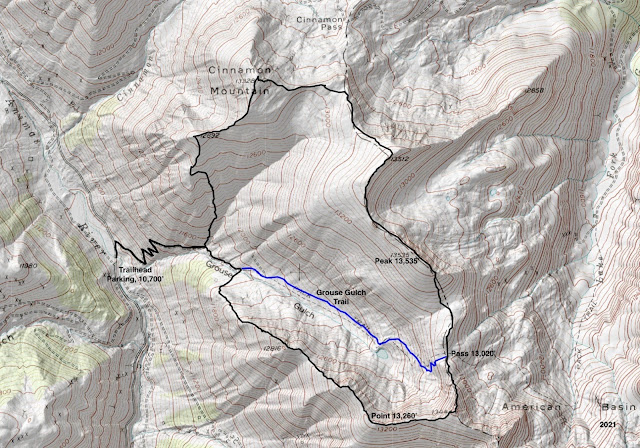

Right away there is an incomparable view of Niagara Peak, ranked 101 in Colorado at 13,807 feet. The first prominence on the south rim, short but fierce Point 12,816', is image-left. At 0.3 mile, the trail switchbacks to the north. Ridge purists may leave the trail there, cross Grouse Gulch creek, and ascend steeply southeast through lovely woods on the softly rounded ridge.


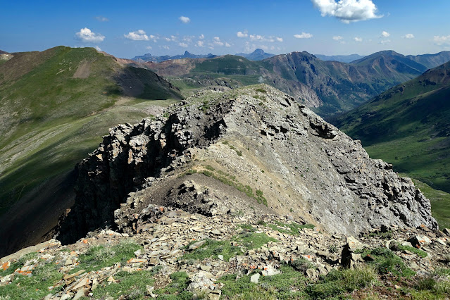
The linear prominence is composed of big playful blocks.


South Rim, Point 12,816'
From the parking pullout, elevation 10,700 feet, walk north up the road and cross the bridge over the Animas River. At 0.1 mile, leave the road and turn southeast onto the unsigned Grouse Gulch Trail. While Handies Peak is only five miles away, the vast majority of fourteener baggers leave from the trailhead in American Basin. This trail sees very little traffic, unless you happen to be hiking while the Hardrock Hundred Mile Endurance Run is underway.


To moderate the initial 1,000 feet and to cross the creek at a lower volume, stay on the trail as it switchbacks up along the south flank of Cinnamon Mountain. Cross the stream flowing from the basin formed by Cinnamon Mountain and Point 13,512' at 0.85 mile. The descent route rejoins the trail there.
The grade moderates at 11,720 feet. An ore car abandoned beside Grouse Gulch creek, shown, indicates the location of a subtle old roadcut at 1.1 miles. To access the south rim, cross the creek at the ore car and follow the abandoned road toward the miner's cabin noted on the Handies quad. This dwelling was standing in 2012 but the log structure has since been demolished by a fallen tree.
(One of the unusual features of this hike is the established trail bisecting the circuit. If you wish to take a pass on the south rim portion, stay on the trail to the pass between Grouse Gulch and American Basin. You may access the north rim from there.)

Gain the northwest ridge of Point 12,816' at about 1.2 miles, 11,900 feet. The undeniably steep incline is a mix of rock and grass. We saw no evidence of footprints but elk created fragmentary game trails.

The pace slows upon entering large blocks at 12,400 feet. It is a hearty class 2+ with charming little passages wending between boulders.

The sense of exposure increases. Be ever mindful of the abrupt precipice all along the radical north wall of this ridge and its prominences. (THW, photo)

The crest has a way of backing off but the climbers below are closing in. The North and West forks of the Animas River join at the base of Houghton Mountain in the ghost town of Animas Forks to form the main channel of the Animas. (THW, photo)

This group is gathering on the tiny, broken stone apex of Point 12,816' at 1.7 miles after putting away 2,100 feet of elevation gain. If our history is a good indicator, it will take between 1:20 and 1:40 from the trailhead to reach this first prominence.

Point 13,444'
These practiced scramblers are down-climbing the east side of the dark tower. (THW, photo)

Continue on the ridgeline up and over unnumbered Point 13,260', shown. In places, the south slope rolls off comfortably, in others, the spine is quite narrow.

The linear prominence is composed of big playful blocks.

The north wall of Point 13,260' has an imposing and commanding presence. (THW, photo)

The ridge bends to the east and looses minimal elevation on its way to Point 13,444'. The stilled rock glacier in Burns Gulch is cradled by American Peak, 13,806', and Jones Mountain, 13,860', ranked number 78 among Colorado's Centennials.

Figure about an hour to span the one mile from Point 12,816' to Point 13,444'. The roomy crest feels like a legal summit but as the terminus of the crenelated northwest ridge of American Peak, it doesn't gain enough lift. This is a stupendous vantage point over the southern San Juan Mountains, the definition of wild country. Handies Peak, 14,048', is cloaked in green velvet. Inevitably, you will see people on its massive summit. (THW, photo)

Pass 13,020'
The north ridge downclimb from Point 13,444' has a short section of exposure right at the top that warrants everyone's unswerving attention.

The descent to the saddle presents in different layers with varying degrees of exposure. First is a scramble with one low Class 3 move. A green slope leads into loose orange rock with tight, almost vertical chutes peeling off to the west. Climb a green knob and then descend a scree slope to the pass.

This image was shot from the scree slope looking down on the pass, the first roller on the north rim traverse, and Peak 13,535'. Tag the pass at 3.1 miles after 2,840 feet of elevation gain. On our loop attempt in July, 2021, the sky was already blowing up mid-morning. The exposure to lightning on the north rim is ceaseless so we bailed on the Grouse Gulch Trail. We spotted five elk moseying along on the ridgeline.

North Rim, Peak 13,535'
Hike right over the first roller and then launch the 500-foot heft up the south slope incline. Footing is good on a typical mix of chipped rock and flora. The grade moderates before the finish on Peak 13,535' at 3.7 miles, shown. Look over the edge onto a rock glacier that scoots on down into American Basin, headwaters of the Lake Fork of the Gunnison River.

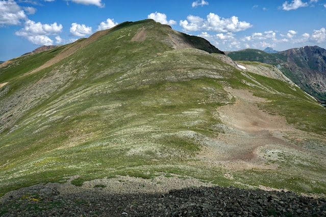
Cinnamon Mountain, 13,328'
Swing with the ridge as it makes a big arc northeast to Point 13,512', the orange chipped knob pictured above. Well off to the north in the Uncompahgre Wilderness is the triumvirate: Wetterhorn, Matterhorn, and Uncompahgre peaks. (THW, photo)

Pivot northwest from Point 13,512'. Cinnamon Mountain is in clear view (image-left) and so is Cinnamon Pass with its vehicle traffic and noise. North of the road is one of our all-time favorite hikes, Animas Forks Mountain, The Catwalk, Point 13,708', and Wood Mountain.
Blocks along the north edge are folding away in big chunks. A cairn in the 13,020-foot saddle marks a trail coming up from the pass. I've always admired travelers who pause long enough on a vehicle pass to climb a peak or perch. The people trail actually assists for a short distance. The orange rock we'd been hiking through is slightly muted here. A better descriptor is...cinnamon. Top out for the last time on the circuit at 5.3 miles. There were no peak registers on any of the prominences.

Grouse Gulch Trail
Descend on the south ridge. We saw two ptarmigans dressed in their rock-colored summer attire. Scramble downward through a short stretch of large talus and then negotiate a rubble field. Tundra takes over as the ridge swings toward the west to tag Point 12,892', image-right.

On my first loop hike in 2012, we stayed on the south ridge clear to the trail. It is crunchy and steep but works fine. In 2021, we scoped out a superior route. At 12,520 feet, we moved east and transferred onto an interior ridge, shown. It will be obvious when you get there.

We did an easy lateral back to the south ridge at 11,860 feet to avoid a waterfall and cliffs. This image was shot previously when we were casing it out for a group hike.

Descending, we were treated to a superlative view of the south rim where we'd been just a few hours and a surprisingly few miles prior. We closed the loop where the stream from Cinnamon crosses the Grouse Gulch Trail at 6.5 miles.

In 2021, southwest Colorado had monsoonal rains nearly every day. By mid-summer, the flowers were glorious. This display was alongside the ore car. (THW, photo)

Trailside, there was an explosion of harebells. (THW, photo)

Thank you to Robert Thompson and Dan Honig, Silverton area explorers and friends who discovered this route and shared it with me in autumn, 2012. (THW, photo)

No comments:
Post a Comment