Essence: Long miles on a popular trail, then an undemanding off-trail loop to two ranked peaks. The ridge between the mountains is one of several compelling features of this hike. We passed by E1 and E2 many times over the years; there were no trip reports for either prominence. In July, 2021, we made it to the 12,300-foot saddle before getting weathered out. Our successful hike in August, 2021, yielded an even better route than we anticipated but the triumph was diminished by a sky laden with smoke from wildfires across the Western U.S. We returned on July 11, 2023 and rehiked E1 and E2 via Jura Knob. See the end of this post for a map and statistics. Based on new, more accurate measurement technology LiDAR, the elevation of E1 has been increased to 12,718 feet with a rise of 401 feet. E2 is now pegged at 12,774 feet with a rise of 326 feet giving it ranked peak status.
Travel: From Durango, drive north on U.S. 550 for 35 miles to Coal Bank Pass. Turn left/west 0.1 mile north of the pass (mile marker 56.9) onto a dirt road that leads to trailhead parking. There is a seasonal outhouse on the east side of the highway but no water.
Distance and Elevation Gain: 15.5 miles; 3,950 feet of climbingTotal Time: 7:00 to 9:00
Difficulty: Trail for 12.9 miles and off-trail for 2.6; navigation moderate; Class 2+ with no exposure
Map: Engineer Mountain, Colorado 7.5' USGS Quad
Latest Date Hiked: July 11, 2023
Quote: The earth laughs in flowers. Ralph Waldo Emerson
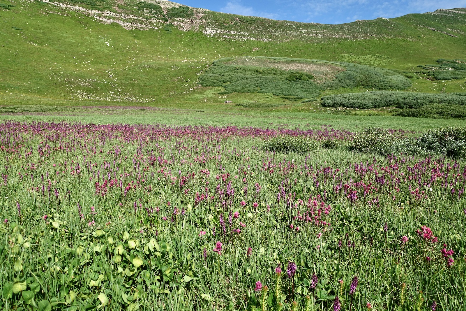
E1 and E2 frame a ridge west of Jura Knob and east of Cascade Creek. The Colorado Trail wraps around the prominences on the northwest. (Thomas Holt Ward, photo)

Route: From Coal Bank Pass, hike generally east on the Pass Trail. Walk north on the Engineer Mountain Trail until just shy of the junction with the Colorado Trail. Climb the east ridge of E2 and then traverse south on the ridgeline to E1. Continue south and intersect the White Creek Trail. Hike northeast to the junction with the Engineer Mountain Trail and retrace your steps. The blue line represents an alternate route to (or from) the saddle. E1 and E2 refer to an alpha-numeric naming system on the 15 minute Engineer quad. E3 and E4 are nearby, often climbed with Jura Knob.

Pass Trail (aka Pass Creek Trail)
The Pass Trail begins at elevation 10,660 feet and launches immediately into flower insanity. The summer monsoons were so powerful in 2021, corn husk lily and green gentian were easily seven feet tall. Their ivory blossoms, along with big-platter cow parsnips, were offset by purple delphinium and Whipple's penstemon, yellow little sunflower, and orange Indian paintbrush. This is surely one of the consistently best floral landscapes in the Southern Colorado mountains.

The flowers are living on an avalanche slide path. Beyond the winter peril, the trail delves into deep spruce woods hanging above U.S. 550. The weathered Paleozoic limestone in the area is a sedimentary layer tilted by the San Juan uplift. Sea creature fossils impregnate the limestone boulders. Pass a reflection pond undergoing the time-honored Earth process of turning into a meadow.

If you have an affection for queen's crown, turn off on a short spur at 1.5 miles and you will find them beside a talkative brook. (THW, photo)

Emerge onto the Engineer Plateau at the "Bus Stop," a sitting log with a view of Engineer Mountain.
Engineer Mountain Trail
The Pass Trail ends at the junction with the Engineer Mountain Trail (EMT), elevation 11,660 feet, 2.5 miles. The deeply etched north face of Engineer Mountain casts long shadows in dawn light.

Walking north, at 3.0 miles the trail gives up 150 feet going into the Coal Creek depression. This is the first of many undulations on this pathway. At 3.55 miles, the Coal Creek and Deer Creek trails branch to the east. Stay straight on the EMT. The interplay of old spruce stands and wildflower-infused meadows is sublime. Magenta paintbrush was featured in July. Just three weeks later, three varieties of cobalt blue gentian were showcased--little, bottle, and fringed. Both peaks and Jura Knob (far right) are visible from this meadowland perspective.

After climbing to 11,800 feet, the trail loses another 300 feet as it drops into the Engine Creek drainage. The path falls and rises as it negotiates streamways on the west slope of Jura Knob. A filament of water falls into a moss and fern-laced grotto at 5.0 miles. There is an excellent view of the southeast ridge of E1 from the trail. We gave serious thought to using the ridge as a descent strategy but it was too troubled with cliffs.

Arrive at a signed three-trail junction at 5.4 miles, 11,500 feet. The Engine Creek Trail joins from the south. The White Creek Trail, favored by mountain bikers, goes west around the south end of E1 and links with the Colorado Trail (CT). The EMT points north and terminates at the CT east of E2. To initiate the loop described here, go north on the EMT.

The EMT grinds uphill keeping the stairstep cascades of Engine Creek to its west. The water emanates from a cluster of ponds in a glacial basin east of the small divide linking E1 and E2.

The first time we attempted the peaks, the weather blew up so we abandoned our loop plan and made for the saddle, shown. We walked on a gray limestone rim which deposited us into thick stands of willows and extensive bogs. If the saddle is your intention, leave the EMT at the distinctive red bench. This route is discussed more thoroughly later.

E2, Peak 12,766'
At 6.5 miles, 12,200 feet, leave the EMT and ascend the east ridge of Peak 12,766', staying just north of the willow line, shown. This image was shot from the west slope of Jura Knob. (THW, photo)

From the ridge, look down on the junction of the EMT and the CT. The benchland south of Twin Sisters is riddled with tarns. The bright cluster of tents is an aid station for the Silverton Dirty 30. It was an unfortunate day for a hike (August 7, 2021), let alone a 100-mile footrace. The smoke from wildfires burning vast tracks of land further west was oppressive and dispiriting.

The east ridge climb is mellow. Some flowers are especially notable mid-summer. Watch carefully for pygmy bitterroot, Lewisia pygmaea. The plant is so close to the ground its succulent leaves and pink flowers are easily missed. "Lewisia" refers to Meriwether Lewis (leader of the Lewis and Clark Expedition) who collected the first specimens for science in Montana in 1806. (THW, photo)

Once we went searching for and found Colorado tansy aster on the south ridge of Jura Knob. So it wasn't a surprise to see it thriving on the east ridge of E2. It is a U. S. Forest Service Rocky Mountain Region Sensitive Species and its existence is threatened.

The ridge tightens briefly at 12,500 feet and then opens onto a broad platform just before the summit. The finish is charming with little green pathways between red, coarse-grained Cutler Formation boulders. Alight on E2, at 7.1 miles.

Saddle 12,300'
The traverse between E2 and E1 is the most enjoyable segment of this long trek. Hop across a small talus pile and then meander on tundra passages through more granular boulders. (THW, photo)

Clamber through and around deep cracks in iron stone--big, bold, shattered and jumbled. Green lichen clings to the sharp-edged mustard and black angular blocks. The gentle roller north of the saddle was covered in the scat and stench of a domestic sheep herd bleating away by the thousands on the slopes of E1 and in the basin in August of 2021. (THW, photo)

Drop into the saddle at 7.8 miles. This vantage point features a sensational perspective on the southeast ridge route up Grizzly Peak west of the massive Cascade Creek drainage. Rolling Mountain that truly does go on forever, is image-right.

Red Bench Route to EMT
If you need to bail from the saddle, it is a simple 1.1 mile hike east to the EMT. Jura Knob, E3, and E4 are seen east of the trail.

Locate the game trail that leaves from the saddle and does a descending traverse to the southeast for 0.3 mile.

Staying above the marsh, curve to the northeast and walk on the red bench all the way back to the EMT. Look out over the best of willow-infused bog world: rills; tarns; and magenta paintbrush, queen's crown, and elephant head.
E1, Peak 12,703'
There is a sheep trail right on top of the north ridgeline. The climb is obstacle-free, easy going, and mostly tundra--nothing to it. We rounded out on the expansive smooth summit dome of E1 at 8.2 miles. (THW, photo)

South Ridge to White Creek Trail
We had planned on returning to the saddle but the sheep were a deterrent and we were curious about a possible route down the south ridge to the White Creek Trail. We had no idea what the cliff features would throw at us.
If you intend to follow this route, be sure you are descending on the south ridge and not the cliff-ridden southeast ridge, or the southwest ridge which leads to the historic (and vanished) Highline Trail. You'll know you are on the correct ridge if you are walking directly toward Engineer Mountain, shown.
Starting down the gamble, we could see the White Creek Trail below. The white cliff band at 12,400 feet was broken and posed no problem. (THW, photo)

At 12,000 feet, we were standing on top of a mountain-wrapping Cutler cliff band, the same rock that composes the Class 3 Corner Wall on Jura Knob. We started probing to the west and discovered an animal path treading through a weakness in the wall. We got very lucky--it would have been a brutal go-back on a long, smoky trek. We no longer heard the sheep, there were elk tracks everywhere, and we had a clear shot to the White Creek Trail. All right! This image looks back up at the cliff from the White Creek Trail. (THW, photo)

Return to Pass Trailhead
We contacted the White Creek Trail at 9.1 miles, 11,570 feet, and turned northeast. This EMT to CT connector follows the contour, a welcome interlude on this hike.

Cross Engine Creek, a dependable water source, just before closing the loop at the three-way junction at 10.1 miles. Retrace your steps from there. As it turns out, the south ridge route was 0.6 mile shorter than returning by way of the 12,300-foot saddle. Reserve sufficient energy for the roughly 550 feet of vertical accumulated on the return to the Engineer Plateau. Platter-sized boletes were growing near the creek during a soggy summer. (THW, photo)

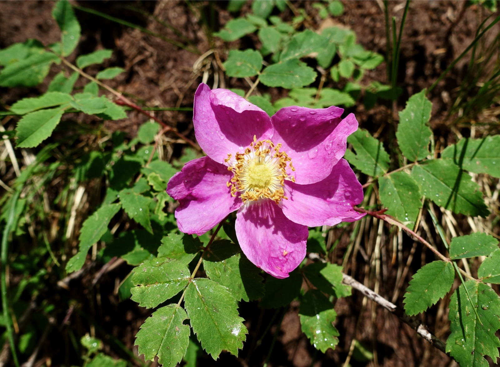
There is a lot of exposure to lightning on the EMT. By mid morning in July, it was raining with lightning strikes close by. We jogged most of the way to the trailhead but stopped to take a photo of this woods' rose on the Pass Trail. They put out the best fragrance on earth.
We once again passed through Flowerland just feet from the trailhead.

Jura Knob Approach
We began on the Coal Creek Trail, climbed Jura Knob, then E2 and E1. We returned on the White Creek Trail, Engineer Mountain Trail, and Coal Creek Trail. The distance was 13.1 miles and the accumulated gain was 4,160 feet. It was 1.4 miles shorter than the Pass Trail approach but added 200 feet of gain. Please link to Jura Knob for a description of the Coal Creek Trail and peak.

E1 from the south ridge of Jura Knob.

Be aware that there is a tough Class 3 climb at the Corner Wall near the Jura Knob summit. The wall is impossible for dogs (and some solo hikers).

No comments:
Post a Comment