Travel: From the US 160/550 intersection in Durango, travel 11.0 miles west on US 160 to Hesperus. Turn right/north on La Plata Canyon Road, CR 124. Zero-out your trip meter. There is a brown, US Forest Service sign with mileages right after the turn. After passing the hamlet of Mayday, the road turns to smooth dirt at 4.6 miles. There are several established campgrounds in this area. In 8.5 miles the roadbed deteriorates with sharp, sizable rocks. A 2WD vehicle with good tires and moderate clearance may proceed. Park at 10.6 miles, 9,880 feet. The hike goes west up FS 798. With high clearance, 4WD low, and skill, it is possible to drive up the steep and rocky two-track 1.9 miles to 10,950 feet.
Distance and Elevation Gain: 8 miles and 3,800 feet of vertical from La Plata Canyon Road
Time: 6:30 to 8:00
Difficulty: 4WD road, off-trail, steep slopes; navigation challenging; Class 3+ scrambling; considerable exposure
Map: La Plata, Colorado 7.5 Quad
Latest Date Hiked: August 30, 2018
Quote: Life is either a daring adventure or nothing at all. Helen Keller
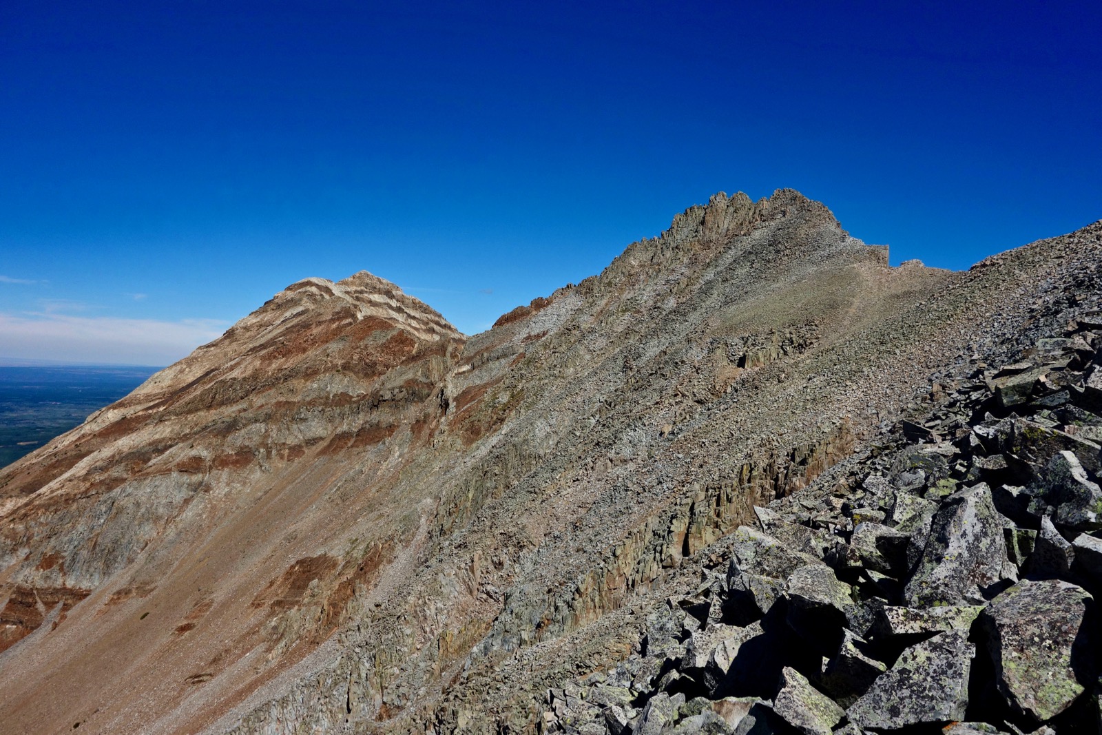
Mount Moss and Lavender Peak on the horizon, as seen from Centennial Peak.

Route: From Trailhead 9,880', walk westerly up FSR 798 for almost two miles. Leave the road and ascend off-trail into upper Tomahawk Basin. Climb steeply to gain the south ridge of Mount Moss. Scramble up the three towers of Lavender Peak before contouring below Mount Moss on your way back to the south ridge.

Walk up FSR 798 through an aspen forest interspersed with talus flows. In
1.0 mile you will reach a juncture with the
Tomahawk shortcut trail. For a leisurely ascent, simply stay on the
road. For a steep, shorter alternative, punch up a social trail that
cuts west of the tailings pile and Tomahawk stamp mill before rejoining
the road. The mill was built by the Tomahawk Mining Company in 1904. Exploratory work was done on promising veins in diorite stock. Recovery of precious metals was poor, at most 0.6 ounces of gold to the ton. Mining operations in Tomahawk Basin concluded in 1911. (THW, photo)


At 1.9 miles, 10,950 feet, leave the old wagon road as it makes a sharp switchback to the east at the Little Kate Mine. Follow a reasonable social trail up an angled slope to a bench, staying well right of the rock outcrop seen below. Or, as indicated on the map, punch up the ultra steep shortcut.

A faint path utilizes the bed of a historic, steel pipeline. Next, bypass the waterfall, shown, on its right/north. A scant path climbs right of the rock outcrop before turning left through a short stand of willows. Or take the steeper option just left of the outcrop.

Pass a couple of black boulders. The long-abandoned mine road moves closer to Basin Creek, all the while bearing west. The rocky track is particularly useful crossing a large talus field. The gently rising basin butts up against the highly angled slope at the base of the ridge at 12,100 feet.
An unassailable section of ridge flows south from Mount Moss before it is splintered by weaknesses. I have gained the ridge in many locations; they all worked. However, it is easiest to climb the steep, grassy slopes as far to the right as possible--just south of the upper scree field, image-right.

On my last trip up the mountain, I actually stumbled on a short use trail. Looking at the image below, the impenetrable ridge is image-right. Left of it is a gap and then a large ridge fragment, image-center. Just left of this structure is the location of the social trail. After years of experimentation, this is the golden path.

Upon reaching the ridge at about 12,720 feet, turn right/north and almost immediately bypass an obstacle to the west on good rock for about 100 yards, shown. Return to the spine and follow it to the summit of Mount Moss, 13,192 feet. A friend thinks the south ridge of Moss is just a walk, but be prepared for some Class 2+ chunky talus scrambling.

Hesperus Mountain and the three towers of Lavender Peak are a stone's throw to the northwest.
Looking back, the south ridge of Mount Moss terminates at West Babcock Peak. In the image below, starting from the left is East Babcock Peak, Fourth Crest, Middle Babcock Peak, West Babcock Peak, The Knife, and Spiller Peak. (THW, photo)

Summit Mount Moss at 3.7 miles. The crest is topped with great sitting rocks. Directly north is Centennial Peak, 13,062 feet, image-right. Amazingly, skilled climbers have traversed the spike-encrusted ridge from Centennial to Lavender Peak and on to Hesperus Mountain. (THW, photo)

If you are tapped or the south ridge of Mount Moss tested your mettle, this is your turn-around summit. Class 3+ scrambling with exposure is required to surmount all three towers of Lavender Peak, shown. The rock is good, the experience superlative. From Moss, descend northwest on well-seated talus to the saddle at 12,880 feet.

As you begin the Lavender ascent, the side walls of vertical couloirs encapsulate banded Centennial.

Cross a stable, thin ridge to the East Tower of Lavender. Welcome to the castle maze.

Face the rock for the more challenging and spirited downclimb. Some people will need a spot. This tower may be flanked on the south. (THW, photo)

Drop into the wedge between East and Middle towers. Traverse west laterally around the base of Middle, shown.

Scale dependable rock, using four point climbing to reach the divot between Middle and West towers.

Finish on the exhilarating West Tower where you will find the peak register. The zenith is essentially one block of stone with room for three climbers. This image was captured by a camera firing remotely from Middle Tower aimed at West Tower. (THW, photo)

Middle Tower may be cautiously climbed. (THW, photo)

Hesperus Mountain, northwest at 13,238 feet, is the highpoint in the La Plata Range. Which peak is taller was the subject of speculation for years. The highly accurate remote sensing method, LiDAR, has been used to measure both peaks. This new system has pegged Lavender at 13,237 feet, with Hesperus just one foot taller. It is the Sacred Mountain of the North, marking the northern cardinal boundary of the traditional homeland of the Navajo. (THW, photo)


At the insurmountable gendarme, bypass west, regain the ridge, and look immediately for your descent route at about 12,720 feet. The slim use trail is swallowed by tundra 100 feet below the ridge.

Watch for soaring bald and golden eagles, and playful, chortling ravens in the upper basin. The Tomahawk Basin Road is especially pleasant in autumn.

7 comments:
Is there a register at the summit of Mount Moss?
Hey Laura, I don't recall a peak register when I was up there in August. Debra
Hi Debra!
I'm working on a project in the La Platas - a sort of ultimate traverse, from Parrott to Sharkstooth (so specifically: Parrott, Madden, Gibbs, Burwell, Spiller, W. Babcock, Moss, Lavender, Centennial, Sharkstooth). I've scouted some of the trickier sections I hadn't previously done, and currently the only section I'm unsure of is the traverse between Lavender and Centennial - I've heard of people doing it, but don't actually know anyone who has. Since you mention people who have traversed it in this post, I was wondering if you happen to have any information on it, or could point me in the direction of where to look for more? Any help you could give would be much appreciated!
Thank you,
Liz
Hi Liz, Ambitious and gnarly. I asked two friends, both of whom have climbed Lizard Head and are finishing up all the San Juan peaks above 13,000 feet. Here is their feedback: "The traverse between Lavendar and Centennial is technical and probably rather nasty, since the rock is probably of poor quality. I don't know anyone who has done it, but yes, probably someone out there with an extreme taste for adventure has. As an alternative, the traverse from Lavendar to Hesperus is fun class 3, so perhaps Liz would consider going from Lavendar to Hesperus to Sharkstooth instead -- or even Lavendar to Hesperus to Centennial to Sharkstooth?" This next comment is from a man who crossed the Knife and finished up all the La Plata peaks when he was 14 years old: "Ropes would be needed for that traverse & I am not aware of anyone that has tried it." Hope that helps. Debra
Thank you so much!! This was definitely the part that looks the gnarliest and that I was hesitant to fully scout without the reassurance of someone else's completion of it. I've done Lavender to Hesperus before, I guess on a map my eyes naturally followed the ridgeline north-south, but that would also be a good finish. It's really just a matter of how difficult the climbing would be, especially ascending Centennial - even with a rope, I'd be skeptical of any gear placements in that rock holding a fall if it happened. Thank you so much to you and your friends for their input! Perhaps some day I'll give it a go... And if not, that's okay too!
Attempted this yesterday (9/14/20). There was quite a bit of snow in the basin! We were unable to find the "golden path" (perhaps it was covered with snow), and gained the ridge too far to the south. Thus, we had too many obstacles between us and the Mount Moss ridge, so that is as far as we got! We will try again when there is NO SNOW! :)
It's so hard to turn back but that was a good call. The rock really needs to be free of snow for these summits. Thanks for the snow report...I was curious. Debra
Post a Comment