Essence: This is a hike of enchantment. Maybe it's the charming name and corresponding shape of the peak. Or, perhaps it's the ring of limestone cliffs setting the crown off so nicely and providing a true challenge to overcome. The Dripping Spring Mountains shed water into the Gila River on the west, south, and east (near its confluence with the San Pedro River); and into Dripping Spring Wash on the north. This route approaches the mountain from the south near the town of Winkelman, population 351 in the 2022 census. Access the climb via old mining roads, pitch steeply off-trail through heavy brush, and scale a 30-foot vertical wall. The hike passes through lands administered by the BLM and Arizona State Trust. The public is welcome on the private land at the Chilito Mine.
Travel: Measure distance from the intersection of AZ 77 and AZ 177 in Winkelman. Drive west on AZ 177 toward Superior. Pass through Hayden. At 3.7 miles, turn north onto a dirt road. There is no sign designating this road but it does continue on the south side of the highway. Plus, there is a stop sign for those exiting the road at the highway. The track is very steep and rocky to begin (sturdy tires and moderate clearance required) but it soon levels off considerably and the surface improves. At 4.9 miles, go left at a fork. The road is on a narrow but comfortable bench above the drop into Schneider Canyon on the east. To do our loop, park at about 7.3 miles on a straightaway, just before a branch that goes steeply up a gully on the west. To shave a solid mile off the trek, continue up the road and start hiking from the Chilito Mine. Open and close the yellow gate. The road is blocked permanently 0.2 mile beyond the mine.
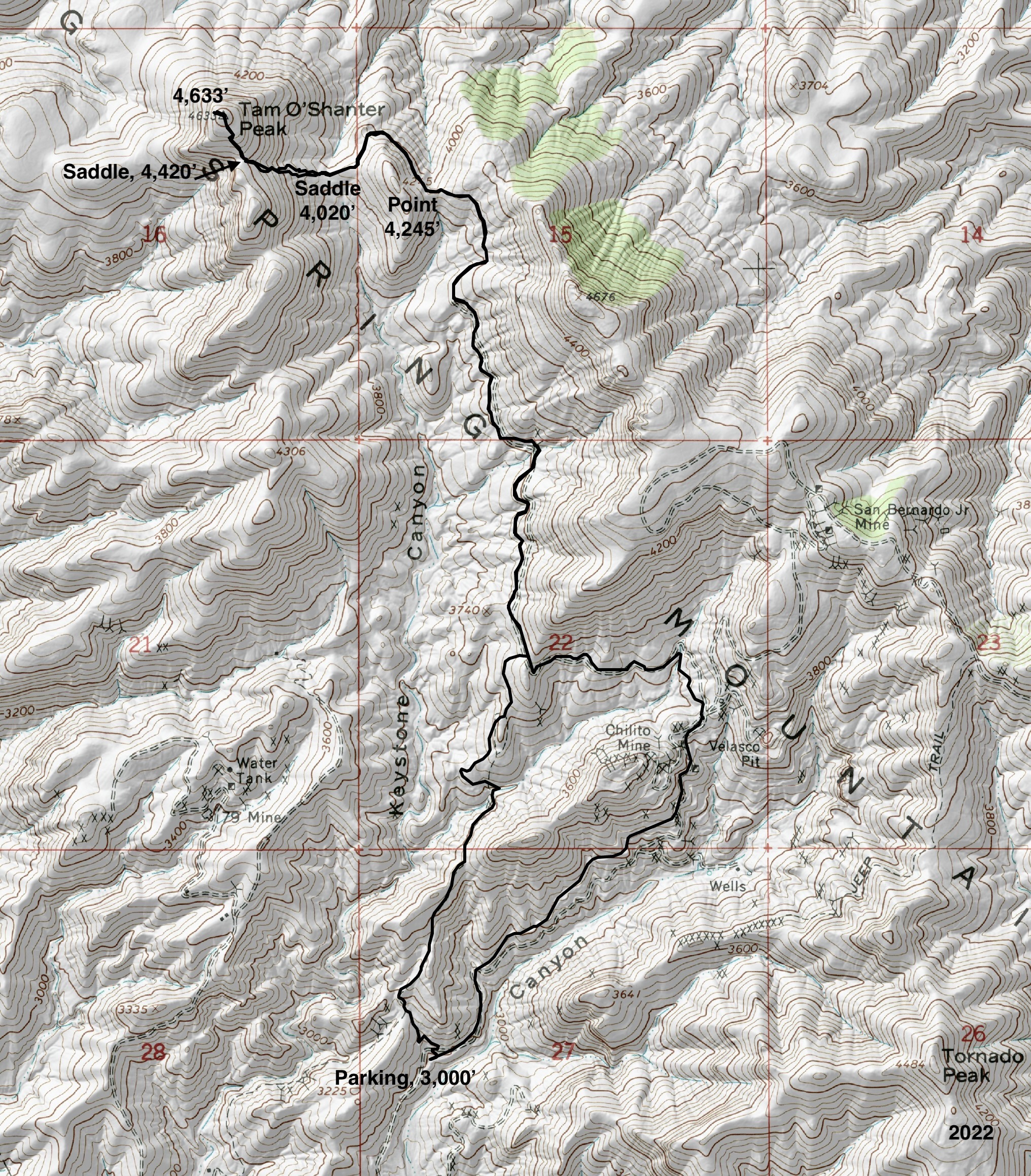
Distance and Elevation Gain: 8.1 miles; 2,100 feet of climbing
Total Time: 5:00 to 6:00
Difficulty: Jeep track, off-trail; navigation moderate; Class 3+ exposed wall; carry all the water you will need and hike on a cool day.
Total Time: 5:00 to 6:00
Difficulty: Jeep track, off-trail; navigation moderate; Class 3+ exposed wall; carry all the water you will need and hike on a cool day.
Map: Hayden, AZ 7.5' USGS Quad
Date Hiked: March 20, 2022
Quote: Walk on a rainbow trail; walk on a trail of song, and all about you will be beauty. There is a way out of every dark mist, over a rainbow trail. Robert Motherwell
Date Hiked: March 20, 2022
Quote: Walk on a rainbow trail; walk on a trail of song, and all about you will be beauty. There is a way out of every dark mist, over a rainbow trail. Robert Motherwell
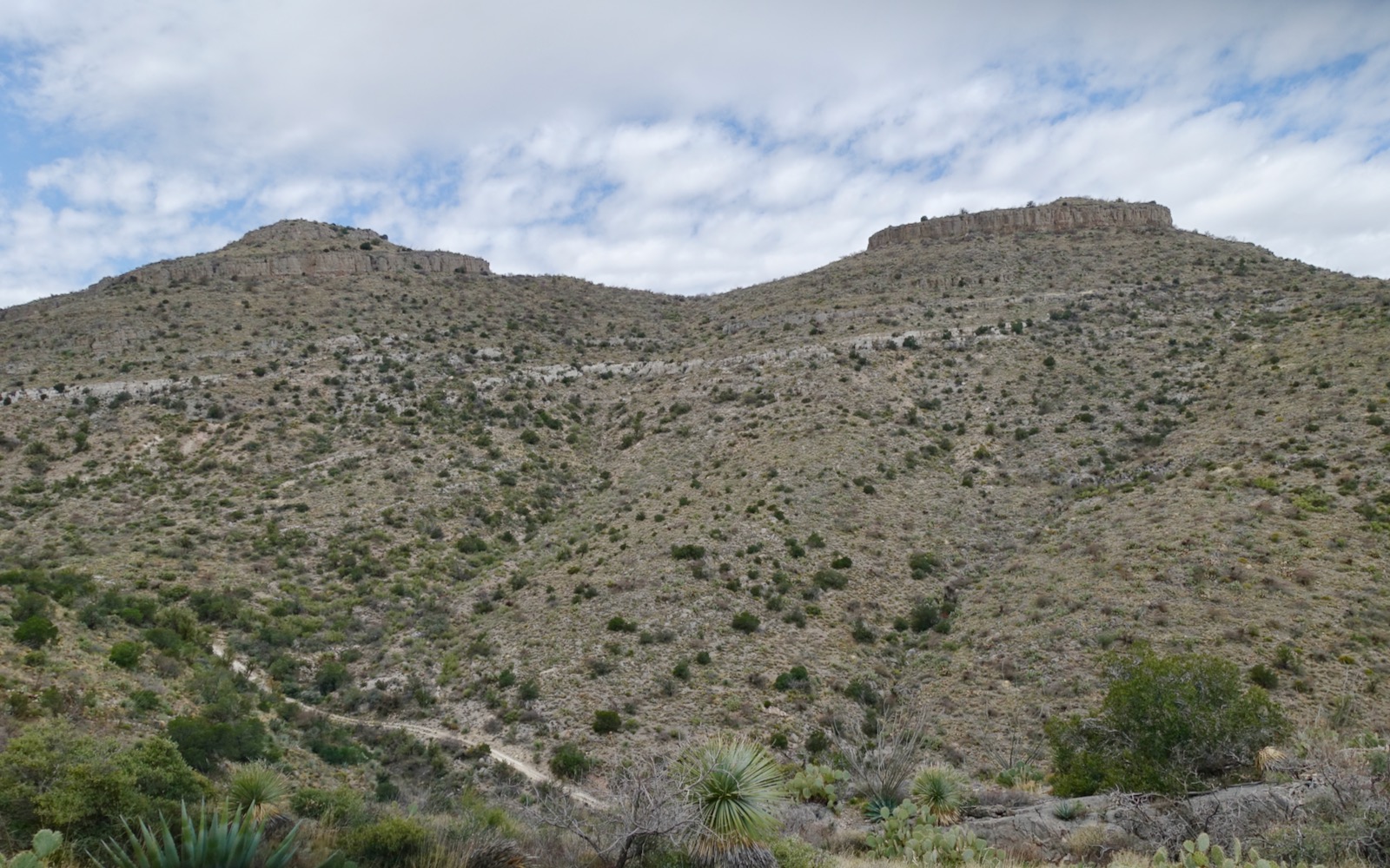
The name Tam O' Shanter Peak refers to a cap that became fashionable in Scotland in the 16th century. It has a flat shape distinguished by a woolen ball at the center of the crown. Limestone cliff bands wander to and fro throughout the Dripping Spring Mountains. (Thomas Holt Ward, photo)

Route: From parking, bear north on a series of mining roads to the saddle east of Point 4,245'. Stay on the road as it curves around the north side of the prominence and descends into Saddle 4,020'. Leave the road and climb west to Saddle 4,420'. Climb northwest to the summit, scaling the wall at 4,560 feet. Return as you came or visit the Chilito Mine to create a small loop.
From the parking pullout at 3,000 feet the road continues northeast to the Chilito Mine. Tornado Peak is due east (image-right) and Point 3,641' is east of Schneider Canyon.

Begin the hike on a rough, rubbly track that branches off the main road bearing northwest alongside a gully. Round the corner and ascend on a bed of chiseled white limestone.

The road splits at 0.6 mile at the base of a quartzite cone cloaked in teddybear cholla. Turn left, staying on the main road as it descends 80 feet into a northeast fork of Keystone Canyon.

The dark hue of the tributary is stained Dripping Spring Quartzite. The 400 foot thick layer is the top formation of the Apache Group in the Globe Copper District. The lower portion of the unit is streaked buff and pink. The upper layer is rusty-purple (seen on the cone). The cliff-forming, resistant quartzite is overlain by Globe Limestone.

The flora is pure Sonoran Desert. Accompanying you all the way are saguaro, palo verde, ocotillo, and pricklypear. Wildflowers were sparse in the spring of 2022. We saw a sampling of fairyduster, brittlebush, wild hyacinth, desert globemallow, lupine, desert four o'clock, chicory, penstemon, deervetch, verbena, and cheerful desert marigold.
(THW, photo)


I found the pot of gold at the end of the rainbow when we happened upon a Gila monster, my first sighting. The slow moving reptile was easy to spot with its bright pink and black reticulated pattern. The Gila monster is one of only two venomous lizards known to occur in the world. The lizard is found in mountain foothills dominated by saguaros and palo verde trees; they are named for the Gila River where they were first discovered. We were on its home turf but still fortunate to see one since they spend most of their lives in subterranean shelters and hibernate from November through February.

At 0.9 mile the track branches. Go left, staying on the main road. Intersect the road coming up from the Chilito Mine at 1.4 miles and turn left. Hang a right at the next fork and see the peak at last, image-center. Cover a lot of ground quickly on the relatively flat two-track. (THW, photo)

Quartzite Peak 4,676' beckons from the road.
.jpeg)
Point 4,245' is characterized by its meandering, perpendicular limestone cliff profile. Descend slightly into the saddle east of the prominence at 3.0 miles. (THW, photo)

The view corridor swings wide open to reveal Pinal Peak and El Capitan Mountain.

To the south are two enormous tailings impoundments associated with the ASARCO Hayden Plant. The copper smelter's 1,001 foot-tall chimney is the tallest free-standing structure in Arizona. The Gila River flows between the tailings ponds. Soil and groundwater are contaminated with lead and arsenic at the Superfund site. (THW, photo)

The track swings around the north side of Point 4,245' revealing Tam O' Shanter (image-right) and the off-trail climb to the 4,420-foot saddle.
Give up minimal elevation descending into the 4,020-foot saddle at 3.4 miles. The road cranks north and descends, no longer of any use. The 400-foot climb west on Globe Limestone is moderately steep. The raw bushwhack is troubled with shindaggers, cat claw, yucca and white thorn.

Reach the 4,420-foot saddle at 3.7 miles. Brush ameliorates from here to the summit. Hike north-northwest to the base of the 30-foot encircling wall at 4,560 feet. (THW, photo)

The Class 3+ pitch turns the hike into a climb and should be attempted only by confident and experienced scramblers. We climbed the wall under the pricklypear but surely there are other viable pitches. The limestone is sticky and holds are good but test even the big blocks for solidity.

Below, the gentleman on the right is standing above the "standard" pitch while a friend successfully explores an alternative location.

This image looks down on two climbers descending. As a short person, I needed a helping hand to make the last four feet on the ascent. Plus, I needed a reassuring spot on the descent. (My camera was having shutter issues which explains the black splotch at the lower left in this photo.)

From the top of the wall it's a casual walk to the crown. We later consulted a botanist and learned that the hybrid California and fishhook barrel cactus, shown, is a rare specimen. The shindaggers have unusually thick, stubby leaves. (THW, photo)

Arrive on the broad circular cap at 3.9 miles where we found the benchmark and No. 1 reference mark. (THW, photo)

This was a new Sky Island for me and I found it thrilling and unfamiliar. Mount Turnbull rises distinctively in the northeast on the San Carlos Apache Indian Reservation in the Santa Teresa Mountains. The Galiuro Mountains are to the southeast. And in the south are the Tortilla, Tortolita, and Santa Catalina mountains, shown.

Returning, once again tackle the wall, regain the road at the 4,020-foot saddle, circle around Point 4,245', and head south below Peak 4,676', shown. (THW, photo)

At 6.2 miles we were back at the road coming from the Chilito Mine. We wanted to see more territory so we improvised a loop adding 0.5 mile to our hike. At 7.0 miles, you'll come to an intersection with two roads going to the right. To see the mine, take the upper road. To return to the start, take the lower. The Chilito Mine was discovered in 1885 by Jack Schneider and closed in 1962. While copper and silica were the primary commodities, molybdenum, silver, and gold, were also mined.
Keep alert for the limestone and quartzite geological contact as you walk down the road. Thank you Dave with the Southern Arizona Hiking Club for leading this hike and for encouraging me to climb the wall.
No comments:
Post a Comment