Essence: Having climbed many peaks taller and tougher in the Monument over three decades, Tillotson finally had its day. What a discovery! The peak is in the very center of the Organ Pipe Cactus world. It was born from fire and is clothed in the colors, and made of rocks, only volcanoes can create. The mountain has a boulder-capped linear summit ridge. This playful, half-day hike is for scramblers who are experienced with off-trail desert exploration. The hike is within Organ Pipe Cactus National Monument administered by the National Park Service.
Travel: From the Visitor Center, cross AZ 85 and measure distance from the beginning of Ajo Mountain Drive. Pass the Diablo Canyon picnic area. When you see the east slopes of Tillotson, you are getting close to the start of the hike. The road descends a few feet into a small drainage, goes up the other side, and makes a 90 degree swing to the right. There is room for just one vehicle in the pullout on the left, 7.6 miles from the beginning of the loop road. Please respect the restoration area by parking in the one designated spot.
Fees and Camping: Consult the Monument website; entrance fees and the camping reservation system have changed repeatedly over the years.
Distance and Elevation Gain: 4 miles; 1,050 feet
Total Time: 3:00 to 4:00
Difficulty: Jeep track, unmaintained trail, off-trail; navigation moderate; Class 2+ scrambling; mild exposure. Hike on a cool day and carry all the water you will need.
Maps: Mount Ajo; Tillotson Peak, AZ 7.5' USGS Quads
Date Hiked: March 24, 2022
Total Time: 3:00 to 4:00
Difficulty: Jeep track, unmaintained trail, off-trail; navigation moderate; Class 2+ scrambling; mild exposure. Hike on a cool day and carry all the water you will need.
Maps: Mount Ajo; Tillotson Peak, AZ 7.5' USGS Quads
Date Hiked: March 24, 2022
History: The peak is named for Minor Raymond Tillotson. He worked for the
National Park Service from 1920 to 1955. He was regional director of
southwestern parks, including Organ Pipe Cactus, in 1940.
Quote: It is an honor to walk where all around me stands an earth house made of scarlet, of jet, of ochre, of white shell. It is more than beautiful at the center of the world. Joy Harjo
Quote: It is an honor to walk where all around me stands an earth house made of scarlet, of jet, of ochre, of white shell. It is more than beautiful at the center of the world. Joy Harjo
Tillotson Peak rises from the Valley of the Ajo as seen from Peak 3,372', the highpoint of the Diablo Mountains.

Route: From the pullout on Ajo Mountain Drive, hike southwest on an abandoned road. Segue to the east ridge and stay on the ridgecrest as it swings northwest and finally north to the summit. Or, as indicated on the map, stay on the trail to a saddle at 2,740 feet and ascend north off-trail to the east ridge. Note: the Mount Ajo topo has 40 foot contour intervals. Intervals on the Tillotson Peak quad are 20 feet.

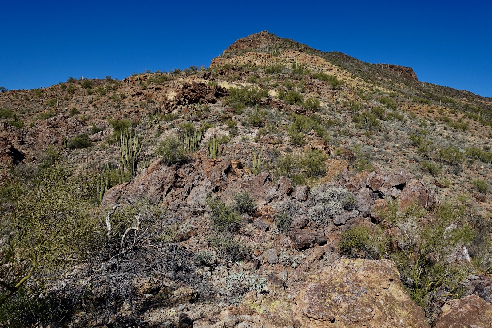
From the small pullout at 2,420 feet, we walked southwest across the open desert. We dropped into and back out of a small drainage and then unexpectedly happened upon a helpful two-track at 0.2 mile. On our return, we followed the track back to Ajo Mountain Drive as shown on the map above. If you'd like to begin on the old road, walk back on the incoming road for 0.1 mile and you will see it bearing west. The Sonoran takes over immediately with organ pipe cactus, chain fruit and staghorn cholla, pricklypear, ocotillo, saguaro, jajoba, palo verde, and the eternal creosote bush. Wildflowers were sparse in 2022 and we longed for the superblooms we'd seen on occasion at the Monument. Below, I'm walking toward Tillotson and the climbing ridge is on or near the horizon left of the summit. (Thomas Holt Ward, photo)

Walk past a forest of organ pipe cactus packed in tightly on the southwest side of a small knoll. The road swings to the northwest and grows faint. Use your intuition to stay the course on the old treadway. At 1.1 miles, another track joins from the right. As you can see on the map, we blew right by this junction on our return so make a mental note or set a cairn so you are sure to retrace your steps. The image below shows the dwindling road and the exciting route to the summit.

At 1.2 miles, 2,540 feet, we left the trail and crossed a shallow ravine to access the east ridge. This turned out to be a delightful route (not too brushy, not too steep) and ridge purists will want to make the move. But, as we discovered on our return, you could stay on the trail to a saddle and then hike off-trail up to the ridge. That option is described later in this post.

Step off the trail and the natural habitat of Tillotson is both beautiful and entertaining. Pinkflower hedgehog clusters were exceptionally large and covered in buds about to burst into bloom. The ridge offered no resistance, just a set of Class 2 rocks to the first knob at 1.4 miles, 2,760 feet.

From the knob you can see the climb ahead and the layering of volcanic material. The Monument is contained within an ancient volcanic field that covers 1,900 square miles. Brilliantly-colored tuff bands interweave with basaltic andesites found on the higher slopes of the mountain.
Maneuver through a complicated band of tuff, an igneous rock that forms from the products of an explosive volcanic eruption. To be classified as tuff, the rock must contain more than 75% ash. The largest and most plentiful assortment of tuff caves we've found are on Pinkley Peak. The lime-yellow lichen is a complex life form that is a symbiotic partnership of two separate organisms, fungus and alga. Our favorite samples in the Monument are on Mount Ajo.

I've passed through a lot of ash flow tuff and always look forward to it. It is fascinating, gorgeous, grippy, and generally free of brush. (THW, photo)

Transition from tuff to a basalt boulder staircase that transports you to a prominent knob, shown. The community of cactus is rich but they are easy to dodge. We found a lot of scat here but could not distinguish between deer and bighorn sheep. (THW, photo)

Top the stony knob at 1.7 miles, 3,240 feet, and pivot north on the summit ridge. (THW, photo)

The ridge is a big boulder affair. The rocks are large, nonsensical, jumbled, and balanced precariously on each other. How did they come to rest in these remarkable positions? Were they blown out of a volcano? The ridge is narrow but never scary; it doesn't drop radically on either side. (THW, photo)

It's about 0.2 mile along the summit ridge in variable terrain.

This false summit is great sport for people who like to get their hands on boulders.

Crest the linear summit platform at 1.9 miles. You will feel like you are on top of the Sonoran Desert and at the very center of the Monument. The peak register recorded only one to two entries a year since it was placed in 2016.


Tillotson garners an uncommon perspective on the Ajo Range to the east. If you are inspired to climb one or more peaks, in order of increasing difficulty they are: Mount Ajo (center-right); Peak 4,158' (image-left); Peak 4,540' (right of Peak 4,158'); and Peak 4,740' and Point 4,700' (left of Mount Ajo).

Southwest are the Twin Peaks (Gadsden and Levy peaks) at park headquarters. Five miles south on AZ 85 is the US-Mexico border in Lukeville. Across the line is the city of Sonoyta and the tantalizing Sierra Cubab range.

Pinkley Peak with the aforementioned caves is in the Puerto Blanco Mountains to the west.

On our return we spotted a trail coming up to the small saddle (image-center, left of tuff band). Out of curiosity we checked it out. Descend through the somewhat loose basalt-andesite material, shown. (THW, photo)

Play around on the tuff band. (THW, photo)

Once in the saddle at 2.4 miles, 2,740 feet, it is rather difficult to find the trail so peg it before you arrive. There was a fair amount of trash in this area and we wondered if this was a migrant trail. The footpath took us back to our upcoming route. We ran the road out to Ajo Mountain Drive at 3.9 miles and turned left to return to our vehicle.
Below, Tillotson Peak displays its south face to travelers on Ajo Mountain Drive.

No comments:
Post a Comment