Essence: There are several approaches to Bonita Peak and unranked Emery Peak from both Minnehaha Basin on the west and Eureka Gulch on the east. This route begins with a traverse over Bonita's north and south ridges followed by an out-and-back to Emery. The mountains are often climbed as a triplet with Proposal Peak; that option is referenced. Capable and brave climbers have strung the three together on the Class 5 ridgeline compromised by friable rock, not recommended by this blog. The route described here is decidedly easier but it's not a gimme. Slopes are steep; ridges are thin; rock is unstable; and exposure is significant. In mid-summer, brilliant green basins with arrays of linked reflection ponds have an abundance of wildflowers. This hike is pure Colorado. It is within the San Juan National Forest.
Travel: In a 4WD (low helpful) vehicle with high clearance, in Silverton drive up Greene Street to the north end of town. Make a soft right onto San Juan County Road 2 and measure distance from there. On a good dirt road drive to the mining ghost town of Eureka where the road crosses the Animas River at 7.8 miles. Look for a sharp left at 8.2 miles rising above the old Eureka Mill foundations. This is Eureka Gulch 4WD Road, the first left after the bridge. The narrow but fairly smooth shelf road clings to the south skirts of Eureka Mountain. The track curves around and follows above the South Fork of the Animas River. Conifers and then aspen give the shelf some sense of protection. On the left a cascade plummets from McCarty Basin into Eureka Gulch. The road becomes rocky, narrow, and steep in the krummholz and columbine zone. At 10.7 miles ignore the fork that descends to the left. Many mining structures and relics remain in the high basin. At 11.3 miles the road splits. Straight ahead is a rough stretch with bedrock boulders. The left option is a bypass. We went left and parked at first opportunity--the further on you drive, the more you will climb at the end of the hike.
Distance and Elevation Gain: 5 miles; 2,300 feet of climbing
Total Time: 4:00 to 5:30
Difficulty: Off-trail; navigation moderate; Class 2+ with moderate exposure; steep slopes
Map: Handies Peak, Colorado 7.5' USGS Quad
Latest Date Hiked: July 8, 2022
Quote: These mountain flowers look inexpressibly delicate; their stems are slender, their blossoms fragile; but burrow a little in the soil, and roots of a timeless endurance are found. Nowhere more than here is life proved invincible. Everything is against it, but it pays no heed. Nan Shepherd, The Living Mountain
Bonita Peak, the name that says it all. Located within the San Juan Volcanic Field, near-black cliffs are interspersed with cascades tumbling down verdant alpine slopes and stilling on a marshy tableland.

Route: A week prior to this hike we climbed Proposal Peak from Minnehaha with the intention of tagging Emery and Bonita peaks on our way around the circuit. We were weathered out which turned into a good thing because it gave us reason to try again from Eureka Basin. We were gifted with a sunny day and so we determined our route casually on the fly. We ascended northwest from parking to Bonita's north ridge. From the summit we descended south to the saddle and then skirted around the east ridge of Emery into McCarty Basin. Both Proposal (blue-line route) and Emery peaks are climbed from this basin. Retrace steps to Emery's east ridge and descend northwest to parking.

Bonita Peak
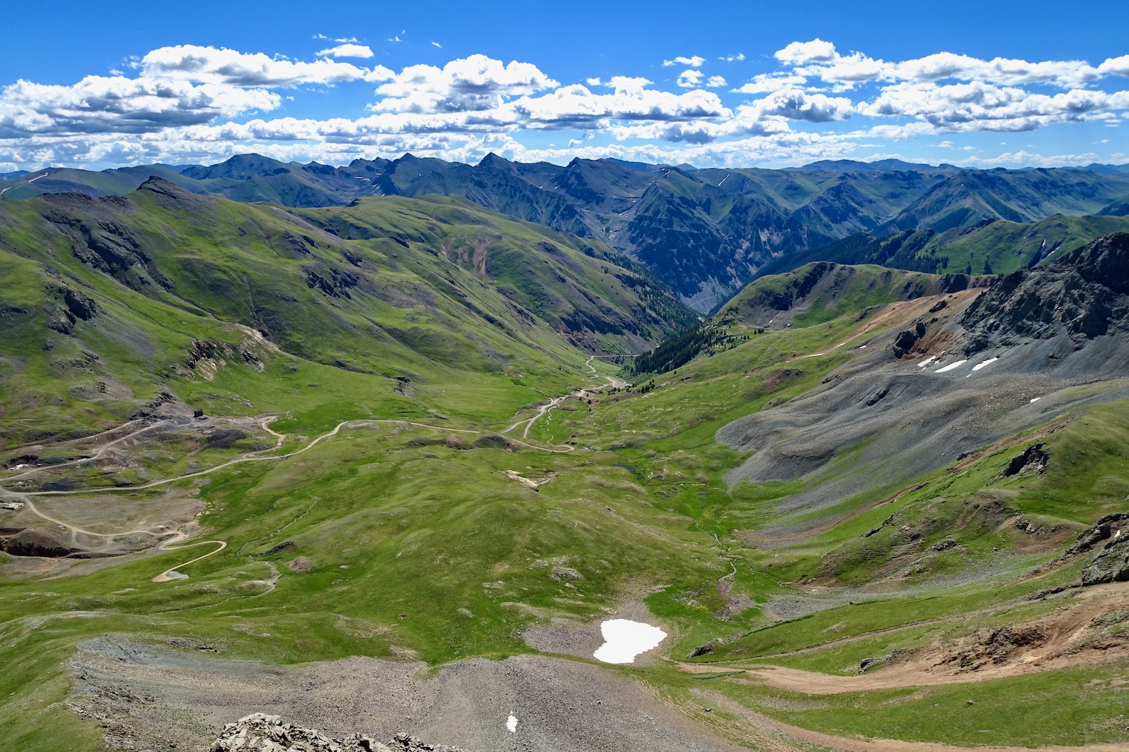
The stitched image below is an excellent overview of the first portion of the hike. From parking near the west fork of Eureka Gulch, elevation 12,020 feet, we ascended to the saddle north of Bonita Peak, image-right. From the summit we descended to the south saddle at image-center. We resisted the tempting (but harrowing) north ridge of Emery. Instead, we walked across the extensive talus bench below the north face of Emery's east ridge, image-left. We went over the ridge on a social trail at 12,400 feet.

From parking, head northwest, immediately crossing a stream. Walk on a thick mat of lush grass and wildflowers. As always, we tiptoed around the flowers as best we could. Looking east to the west slopes of Hanson Peak, it's clear the high basin was ravaged by mining. Roads and structures associated with the Sunnyside Mine, including a cement castle, are strung out and strewn about. Even glacially carved Lake Emma has disappeared, having drained catastrophically into a
mining tunnel in 1978. Thankfully, this occurred on a Sunday, sparing all 125 workers. Despite all the interference, the headwater basin of Eureka Gulch is gorgeous today. (THW, photo)
At 12,280 feet we walked past a grated steel door barring entrance into a mining tunnel.

At 12,280 feet we walked past a grated steel door barring entrance into a mining tunnel.

We heard hoofs on rock on several occasions in different basins. We could smell elk and saw scat and fresh prints in rain-softened dirt. But we never saw the wily animals. The headwall inevitably steepens toward the ridge but the route proved excellent.

We gained the north ridge of Bonita at 12,920 feet, 0.8 mile. Of note: My partner once traversed the ridge starting at Sunnyside Saddle. Heading south we found a hint of a game or social trail just east of the ridgeline making for relatively easy passage.

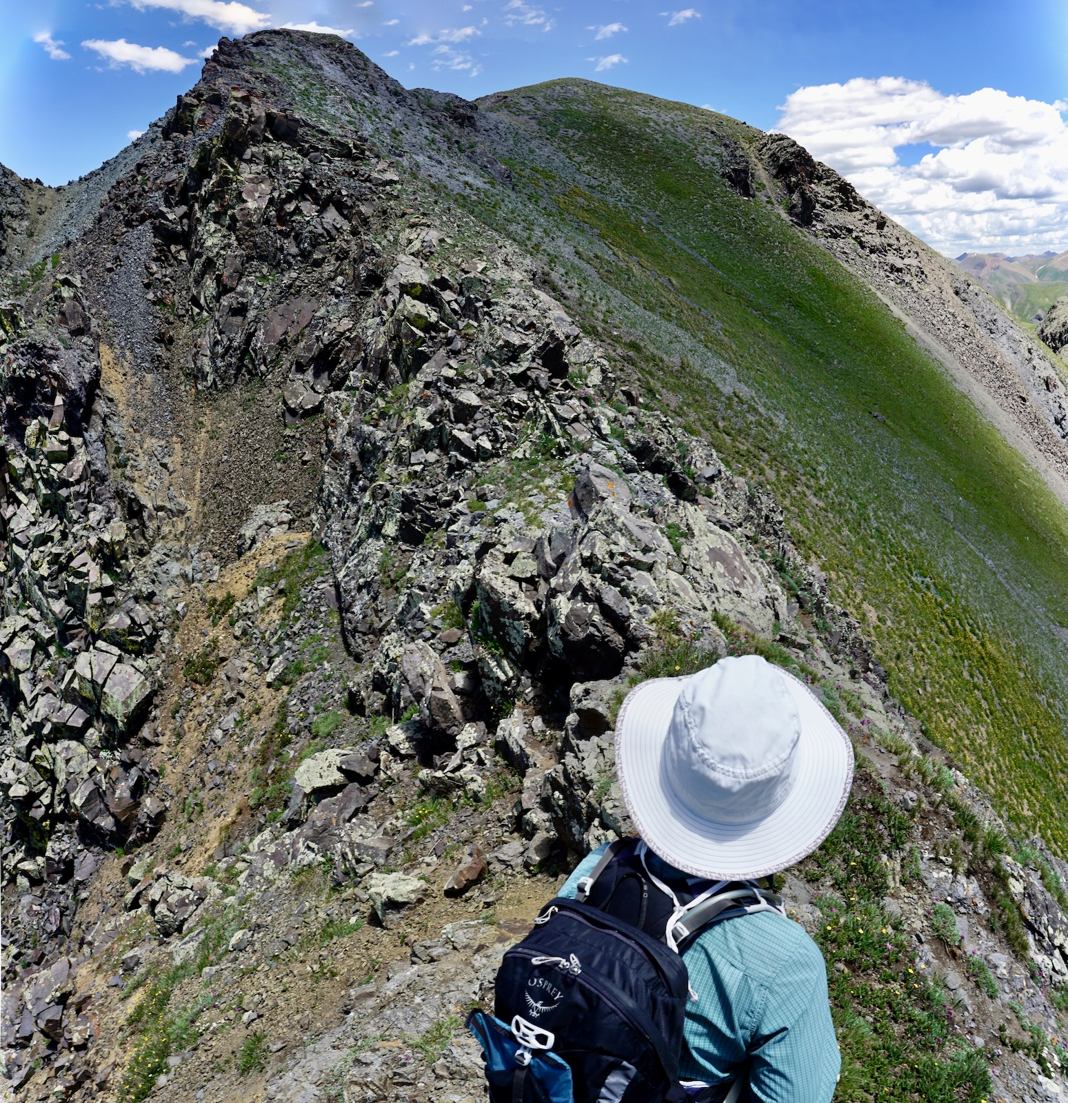
The ridge is friendly in places but razor sharp for short stretches. There's very little solid rock where you want it the most. Test all holds carefully. Brace, don't pull.

Pass over the top of Point 13,228'. In 2011, I climbed Bonita with friends from the Lead Carbonate Mill in Minnehaha Basin. We clawed up the west slope, went up the south ridge to the peak, descended to Point 13,228', and then dropped on its west ridge, shown.

Climb over the tailings pile and scale the tan slide.

The face of the summit ridge on the north is radically different than the south. The summit cone is easy to mount with a thread of trail assisting. As always, the smallest trace of a trail is better than none at all.

The summit ridge is somewhat lengthy, rather crunchy, and decidedly narrow. The views are so enthralling you'll want to pause to take it all in. Behind me, Brown Mountain flows north to Abrams Mountain poised over Ouray. Hurricane Peak is a bit north and west of Sunnyside Saddle. (THW, photo)

Surmount Bonita's tiny crest, the tipping point of her linear summit ridge, just 1.15 miles into the hike after 1,250 feet of gain. The initial segment will take most hikers an hour to an hour and a half. The summit register had few signatures. We saw absolutely no one on this hike (or on our previous Proposal Peak climb).
The circular vista of the southern San Juan Mountains from Bonita is stunning. Eastward, look down on Eureka Gulch and up to Handies Peak, American Basin, American Peak, Jones Mountain, Niagara Peak, and Crown Mountain. The Rio Grand Pyramid and Window were visible off-image.
The west slopes plummet to Cement Creek. The Silverton Mountain ski lift is visible on the north ridge of Storm Peak. Image center is unmistakable Golden Horn and other 13ers in the vicinity of Ice and Columbine lakes.

In the northwest, distinguished by its pyramidal form, Mount Sneffles, 14,155' (with 3,030 feet of prominence), was named after the Icelandic stratovolcano Snaefellsjökull, "snow fell glacier." (THW, photo)

The peak in its tiny glory sits at the north end of the triplet of mountains on this block. Look south to Emery and then southwest to Proposal, with the summit spire. Wild and imposing companions include Dome Mountain left of Emery (climbed from Eureka Gulch) and perilous Storm Peak (accessed from Cement Creek). (THW, photo)

Bonita has 506 feet of prominence calculated from the 12,780-foot saddle at the base of the south ridge. I'm not sure the first 100 yards qualify as a knife edge but I did experience that catwalk sensation where peripheral vision picks up huge drops on both sides. It can mess with your balance. This is a no-fall zone.

The summit ridge cliffs out in an overhung stone ball. We cautiously worked down to the west about 20 feet on broken rock and intersected a social trail. If you are climbing up the south ridge, my field notes from 2011 indicate this rather sketchy trail existed then and intersected the ridge beyond the obstacle. (THW, photo)

This shot of the near-vertical southeast face of Bonita Peak was taken from the little roller above the saddle. If you are not going to Emery, at about 13,000 feet start watching for a ramp dropping east into the basin.

Emery Peak
Descend the roller on a grassy slope and alight on Saddle 12,780' at 1.6 miles. Clearly, the shortest route to Emery is straight up its north ridge, shown. However, there is a vertical, chossy, Class 4+ notch composed of rotten rock beyond the false summit. Trip reports and tales from friends indicate they all wished they'd taken the long way around.
This alternative route goes around Emery's east ridge into McCarty Basin and climbs the peak from the southeast. There's a remnant of an old pack trail in the saddle. It quickly fades away on either side of the pass. Cross the trail and then turn east, roaming freely in this stunning basin.

You will inevitably lose elevation as you step down onto a couple of broad benches. You might get lucky and happen upon a one-boot-wide path that disperses in a talus yard. The approximately 0.3 mile stretch across rock exfoliated from Emery's north face is unavoidable. Do not drop any lower than 12,400 feet. Having been there the week prior going in the opposite direction, we knew there was a thin game or possibly social trail at the far end of the scree. We found it as we were about to round the east ridge at 2.4 mile, 12,440 feet.

The path bears southwest into flowerful McCarty Basin. For those climbing Proposal Peak the best way into Slagle Basin is to cross the 12,820-foot saddle east of the gendarme on Proposal's east ridge, image-center.

Heading southwest, walk pass a reflection pool, one of many tarns on benches stepping down into Eureka Gulch. (THW, photo)

There are options for climbing Emery. We followed the little trail as it climbed 200 feet to the next bench. This is where the Emery-Proposal routes diverge. For Emery, we skirted the scree field, shown, and then curved north toward the peak staying on the tundra. The slope steepens at 13,000 feet. The simplest route to the summit is to stay on the green going directly north. We were curious about the south ridge. Getting onto the ridge was a little spooky. It required powerful, exposed hefts on crumbling rock.

We engaged the ridge at 13,180 feet (the low point between the peaks) only to see a considerable challenge between us and the summit. (This image offers a good angle on the ultra steep tundra pitch.) (THW, photo)
It was tricky and exposed on pretty bad rock. It gave us a beginner's taste for the ridge traverse between Emery and Proposal which is troubled with Class 5 towers.

We topped out on Emery Peak at 3.5 miles. With only 130 feet of prominence, Emery is an unranked summit but a worthy goal. Proposal Peak, just half a mile south, looks like an anvil from this perspective but standing on top it feels like the tip of a spear.

Return to Parking
We debated descending the east ridge but couldn't get a good look at it. So we dropped a few feet back down the south ridge and then skidded down the slope to meet our upcoming route. It was a mix of resistant soil, flower tussocks, and chipped rock.

After crossing Emery's east ridge we made an effortless northwest descent to the bottom of the basin. We were able to cross the west fork of Eureka Gulch on dry ground, just feet from our vehicle.

For the few hours we were on this hike, it felt like Earth was Heaven, like we were still on the redeemable side of climate catastrophe. The monsoons had been going off almost daily for over a month and water was flowing in rivulets, saturating the soil, and giving life to flora and fauna. I made a list of blooming alpine flowers as I walked along.
Veronica, American bistort, sibbaldia, pygmy
bitterroot, alpine avens, snow buttercup and "ten petal" buttercup, fairy candelabra,
clover, purple fringe, Silverton wallflower, king's crown, sky
pilot, deep rooted spring beauty, old man of the mountain, smelowskia, dotted saxifrage, aspen daisy, moss campion, minuartia, alpine sorrel, bluebell, mouse
ear chickweed, orange sneezeweed, marsh marigold, globe flower, purple
violet, columbine, pussy toes, Parry's primrose, snowball saxifrage, brookcress,
elephant head, Drummond's rockcress, queen's crown, and alpine sage. As we drove down through Eureka Gulch growing beside the road were osha, black tipped senecio, delphinium, death
camas, and geranium. The rosy paintbrush in McCarty Basin made the biggest statement of the day. (THW, photo)

No comments:
Post a Comment