Essence: The circuit begins in heavy timber and lifts into the alpine
on the divide between the West Dolores and Dolores rivers. The hike features
an extended, relaxed ridge walk between three peaks. The wilderness is gentle,
not spectacular, but the views are surreal and multihued rocks are in
technicolor. An occasional moto might be encountered but the remoteness and
lengthy drive promises a quiet day on the trail. The Rico Mountains are within
the Dolores Ranger District of the San Juan National Forest.
Travel: Dunton Road is a 32 mile thru-road west of CO 145.
Travel: Dunton Road is a 32 mile thru-road west of CO 145.
South Entrance: For 2WD vehicles, use the south entrance. From Dolores,
drive north 13 miles on CO 145 to mile marker 23.4. Turn left on Dunton Road,
FSR 535, and measure from the junction. The road parallels the West Dolores
River for 25 miles. Asphalt turns to graded gravel at 13.1 miles. At 19.6
miles, Geyser Spring trailhead parking is on the right. The Navajo Lake
Trailhead is on the left at 25.0 miles. The Kilpacker Trailhead is on the left
at 27.1 miles. Enter The Meadows and at 28.0 miles, turn south on FSR 417,
Eagle Creek Road.
North Entrance: Vehicles with 4WD may use the north entrance. From
Rico, travel north on CO 145 for 7.0 miles and turn left at mile marker 53.9
on FSR 535 (just past Cayton Campground). There is no sign on the highway to
alert you. Measure from the junction. Moderate clearance and sturdy tires are
required for the rough and rocky road. The track is steep and very narrow.
Aspens give a sense of security on the shelf. After the initial switchbacks
the road widens slightly. At 4.2 miles, turn south on FSR 471.
FSR 471: The graded gravel road is signed for the Calico and
Fall Creek trails. There is plenty of dispersed camping. Pass trailhead
parking for the Calico National Recreation Trail on the left at 0.8 mile
(outhouse). Parking for the East Fall Creek Trail is in a small pullout (room
for two vehicles) on the right at 6.2 miles. While this circuit starts there,
the road is consistently good another 0.9 mile to the West Fall Creek
Trailhead. No facilities.
Distance and Elevation Gain: 7.9 miles; 3,000 feet
Total Time: 5:00 to 6:00
Difficulty: Primarily on-trail with off-trail spurs to Elliott and Johnny Bull mountains; navigation moderate; Class 2 with very mild exposure on the southwest ridge of Elliott Mountain.
Map: Rico, Colorado 7.5' USGS Quad
Date Hiked: September 2, 2022
Quote: To walk in nature is to witness a thousand miracles. Mary Davis
Lizard Head pins the orientation, El Diente Peak and Mount Wilson cleave the
sky, and low-slung Elliott Mountain is the highest point in the Rico Mountains
west of the Dolores River.

Route: Begin on the East Fall Creek Trail and ascend southeast to the Calico Trail. Hike northeast on the Calico Trail to the south ridge of Elliott Mountain. Climb off-trail to Elliott and then hike southwest on the ridge over Sockrider Peak to Johnny Bull Mountain. Return on the West Fall Creek Trail. Walk northeast on FSR 471 to close the loop.

Route: Begin on the East Fall Creek Trail and ascend southeast to the Calico Trail. Hike northeast on the Calico Trail to the south ridge of Elliott Mountain. Climb off-trail to Elliott and then hike southwest on the ridge over Sockrider Peak to Johnny Bull Mountain. Return on the West Fall Creek Trail. Walk northeast on FSR 471 to close the loop.

East Fall Creek Trail
The trail system is clearly very old in the Rico Mountains. Trail names and
numbers have evolved over the years and inconsistencies appear on the signs.
Begin on what is commonly referred to as simply the East Fall Creek Trail,
elevation 10,460 feet. It is open to hikers, horses, and bicycles but not
motos. Dirt bikes are allowed on the West Fall Creek Trail.

The elder trail ascends gently to the southeast while staying close to the
creek. Roots are exposed on the dirt track, blazes cut into the trees long ago
are mostly grown over, the forest floor is tangled and cluttered with fallen
timber. Some Douglas-fir are generations older than the pathway. In early
September plants had gone to seed at the close of a good flower year. Geranium
leaves cast a crimson hue. There was a profound sense of peace. At 10,900
feet, a spacious glade revealed Sockrider Peak above the canopy.

A sincere effort to moderate the grade was evident on the beautifully designed
trail with its sweeping turns. At 11,000 feet, Englemann spruce take the place
of firs and reorganize the forest. (Thomas Holt Ward, photo)
.jpeg)
Arrive at the junction with the Calico Trail at 1.6 miles, 11,700 feet. The
Calico Trail
is part of the National Recreation Trail system. The 19.2 mile trail begins
off FSR 417 and runs south to the Priest Gulch Trailhead. The trail is open to
dirt bikes though we only saw two from a distance.

The vantage point from the junction is just a hint of the sweeping vistas to come. Lone Cone is the outlier on the far western perimeter of the San Juan Mountains. To its south is Groundhog Mountain. Dunn, Middle, and Dolores peaks are an isolated threesome in the San Miguel Mountains. Little Cone stands alone further north. (THW, photo)

Elliott Mountain
This three-peak circuit uses small sections of the Calico Trail a couple of
times. It is a helpful link to the Elliott and Sockrider saddle. Bearing
northeast, the narrow singletrack crosses a rather steep slope.

Gain the divide at 1.8 miles, 11,900 feet, at the north end of the Sockrider Ridge Trail. The eastward vista is almost incomprehensible in its grandeur. In this image, Telescope Mountain is just across the Dolores River. Further off is Hermosa Peak, Engineer Mountain, Grizzly and San Miguel peaks, and Vermilion Peak in the Ice Lake group.

Stay on the Calico Trail to the 11,860-foot saddle, 2.0 miles. Elliott Mountain is 0.5 mile roundtrip from here. We prefer ridges over steep slopes so we left the Calico and climbed directly up the stony spine.

Well seated rocks created a climber's staircase.

The short, rocky ridge interlude was the most playful segment of the day.
(THW, photo)

Talus dissipated on a moderately steep grassy slope with good footing and no
discernible social trail. Top out on the highpoint of the hike and the divide.
This was our first hike in the west Rico Mountains and we found ourselves
looking at our familiar world from an unknown perspective. The peak register
was signed by a few parties annually.


It's mostly downhill on the north ridge out to Papoose Peak, 11,866'.

Blackhawk Mountain
is the tallest peak in the massif east of Rico. The La Plata Mountains are
image-right.

Sockrider Peak
From the Elliott summit we could see our next two peaks. Sockrider is
image-center and Johnny Bull is on the right in the sun.

We retraced our steps to the junction with the "Sockrider Ridge Trail" at 2.7 miles. The Rico topo indicates this trail was a historic stock driveway that went up and over the peak. While the sign directs dirt bikes onto the Calico Trail, we saw tread marks on the more technical singletrack. (THW, photo)

The ridgecrest trail climbs relatively steeply for 200 feet and then
moderates. A maintenance crew has been blocking off braids, possibly the
Rico Trails Alliance, formed
in 2017.

The trail platform barges right through a scree field. The stony approach just
makes this peak more captivating. A three-foot mounded cairn at a lookout had
pika haystacks stuffed in its crevices. (THW, photo)

While there is some granite and quartzite exposed in the Rico Mountains,
sedimentary layers of sandstone, mudstone, and claystone prevail. Pass through
cinnabar-saturated sandstone.

Mount Sockrider Peak's small tundra crest at 3.1 miles. It is this hike's
midway peak and it renders an impressive view back to Elliott Mountain.
Johnny Bull Mountain is hidden by the green prominence we are about to roll
over. The sky is hazy but nevertheless, Sleeping Ute is visible left of
Eagle Peak and the Abajo Mountains are image-right.
.jpeg)
Johnny Bull Mountain
The Sockrider Ridge Trail skirts outcrops on the left. We stayed right
on the ridge so we could see the gashed and ragged west side.

The trail goes over the green roller, 12,260 feet. We were sorting out the landscape as we hiked. From the top of the roller we could see Calico Peak (the colorful pyramid), Eagle Peak, and Johnny Bull Mountain. We decided to climb Johnny Bull mostly because we liked its name, and because as an unranked summit it is often ignored. Below, the Calico Trail looks like a highway without any traffic.

The Sockrider Ridge Trail ends at the merge with the Calico Trail at 3.9
miles. We got back on the Calico for a short stretch heading west. The track
soon does a big switchback to the south before returning to the ridge at the
Johnny Bull saddle. We were being purists so we stayed on the ridgetop. Rock
is chipped into miniature gray and orange plates. Below, the Johnny Bull
summit is image center.
The West Fall Creek Trail meets the Calico Trail in the Johnny Bull saddle at
4.2 miles. If you've had enough climbing or weather threatens, this is your
exit trail. Johnny Bull Mountain is 0.9 mile roundtrip. If you want to go
directly to Calico Peak, stay on the Calico Trail, shown.

It is simple to stay on or very near the ridgecrest to Johnny Bull but there
is a fragmentary and subtle social trail on the south side of the ridge as
well. Rocks paint the ground in a fusion of maroon and burgundy.

The talus strewn summit and trees in the krummholz zone contrast with the Colorado skyscape.

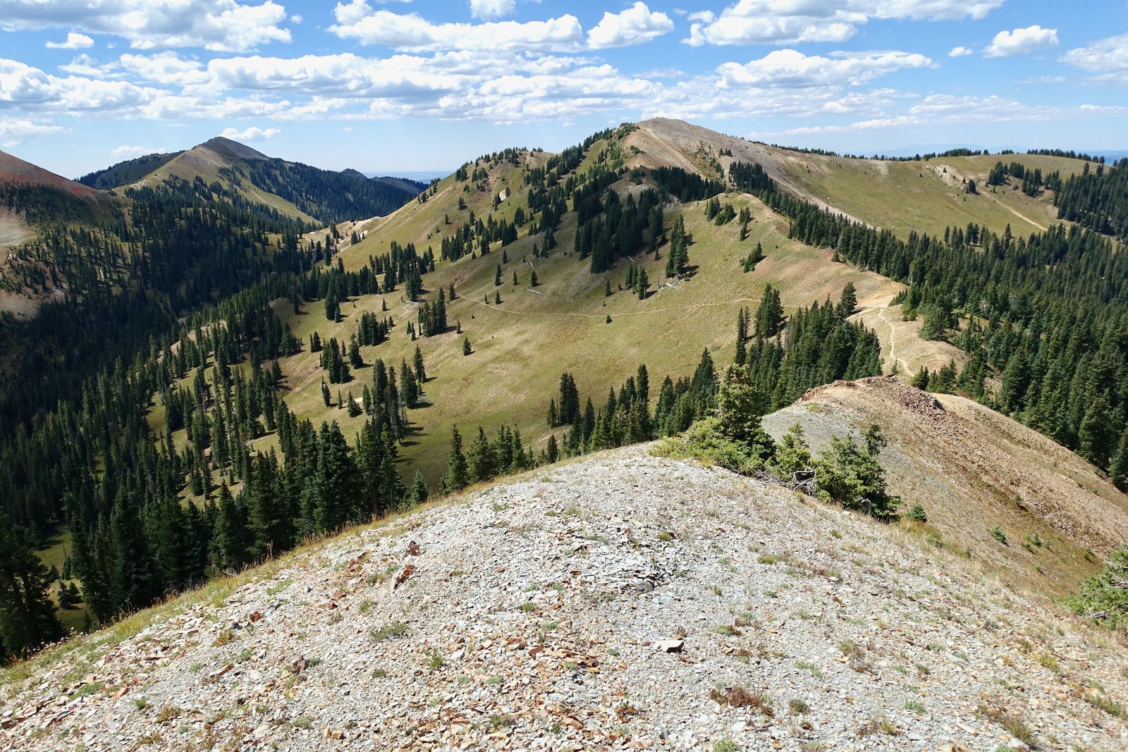
Johnny Bull is yet another of the countless unranked summits not to be overlooked in Colorado. According to Lists of John, this is the only peak in the vicinity evaluated by LiDAR, a new and more accurate measurement technology. The peak's elevation was adjusted upward to 12,029 feet. The saddle elevation comes in at 11,752 feet, giving the mountain a 277-foot rise, just shy of the 300 feet required for a ranked summit. Stand inside the large bivouac and look back on the entire ridge walk to this point. (THW, photo)

Strong hikers could tack on (from the left) Anchor Mountain, Calico and Eagle peaks in one long day. However, the three hour drive from Durango chewed up a good chunk of our time allotment. We'll return and start from the West Fall Creek Trail for the neglected peaks.

West Fall Creek Trail
Return to the head of the West Fall Creek Trail at 5.1 miles. The treadway is
engineered for mountain and dirt bikes with lots of big sweeping turns
creating a mellow descent. Begin in spruce glades and end in an old
Douglas-fir forest. Intersect FSR 417 at 7.0 miles, 10,440 feet. The West Fall
Creek Trail actually continues on the other side of the road. To close the
loop, turn right on the road. Ascend very gradually to 10,520 feet and then
finish the hike on a slight downhill back to your vehicle.

2 comments:
What a great hike! Thanks for posting it. It was very helpful. The north access road off 145 isn’t too bad, I made it pretty easy in a two wheel drive, not sure how long that will last.
Hi Ed, We have a lot of affection for the Rico Mountains so we are glad you enjoyed the hike. I always appreciate comments on access roads. Thank you, Debra
Post a Comment