Essence: This is primarily a trail hike with spurs to three ranked summits on the divide between the Dolores and West Dolores rivers. Climb one or all three. Strong hikers could add Johnny Bull and Expectation mountains. Pyramidal Calico is mesmerizing in its brilliance. Two false summits add delight on the ascent to the Eagle Benchmark. Rise on an arced, tundra-clad ridge to Anchor's broad summit for the best views of the trio. In 2022, we explored the north sector of the divide by climbing Elliott Mountain, Sockrider Peak, and Johnny Bull Mountain. Enthralled by this quiet and diverse range, we returned for three more peaks in 2023 and had one of our happiest hikes of the season. Trails are maintained by the
Rico Trails Alliance formed
in 2017. The Rico Mountains are within
the Dolores Ranger District of the San Juan National Forest.
Travel: Dunton Road is a 32 mile thru-road west of CO 145.
Distance and Elevation Gain: 11.5 miles; 3,700 feet
Total Time: 7:00 to 9:00
Difficulty: Trail, off-trail; navigation easy; Class 2; no exposure
Map: Rico, Colorado 7.5' USGS Quad
Date Hiked: September 9, 2023
Poem:
South Entrance: For 2WD vehicles, use the south entrance. From Dolores,
drive north 13 miles on CO 145 to mile marker 23.4. Turn left on Dunton Road,
FSR 535, and measure from the junction. The road parallels the West Dolores
River for 25 miles. Asphalt turns to graded gravel prone to washboard at 13.1 miles. At 19.6
miles, Geyser Spring trailhead parking is on the right. The Navajo Lake
Trailhead is on the left at 25.0 miles. The Kilpacker Trailhead is on the left
at 27.1 miles. Enter The Meadows and at 28.0 miles, turn south on FSR 417,
Eagle Creek Road.
North Entrance: Vehicles with 4WD may use the north entrance. From
Rico, travel north on CO 145 for 7.0 miles and turn left at mile marker 53.9
on FSR 535 (just past Cayton Campground). There is no sign on the highway to
alert you. Measure from the junction. Moderate clearance and sturdy tires are
required for the rough and rocky road. The track is steep and very narrow.
Aspens give a sense of security on the shelf. After the initial switchbacks
the road widens slightly. At 4.2 miles, turn south on FSR 471.
FSR 471: The graded gravel road is signed for the Calico and
Fall Creek trails. There is plenty of dispersed camping. Pass trailhead
parking for the Calico National Recreation Trail on the left at 0.8 mile
(outhouse). Parking for the West Fall Creek Trail is in a generous pullout on the right at 7.1 miles. Dispersed camping is available at the end of the road in another 0.1 mile. No facilities.Distance and Elevation Gain: 11.5 miles; 3,700 feet
Total Time: 7:00 to 9:00
Difficulty: Trail, off-trail; navigation easy; Class 2; no exposure
Map: Rico, Colorado 7.5' USGS Quad
Date Hiked: September 9, 2023
Poem:
How marvelous to lie back on the blue air,
as the eagle lies back on the wind,
over the cold peaks,
certain of his wings and his breath!
Antonio Machado
as the eagle lies back on the wind,
over the cold peaks,
certain of his wings and his breath!
Antonio Machado
As seen from Anchor Mountain, the divide encompasses Eagle and Calico peaks, Johnny Bull Mountain, Sockrider Peak, and Elliott Mountain, the highpoint in the Rico Mountains
west of the Dolores River. The Calico Trail runs along the ridge providing easy access to the string of peaks. Gracing the distant horizon, Lone Cone
is the outlier on the far western perimeter of the San Juan Mountains. Dunn, Middle, and Dolores
peaks are the isolated triumvirate in the San Miguel Mountains. El Diente Peak and Mount Wilson are indomitable. (Thomas Holt Ward, photo)

Route: Hike south on the West Fall Creek Trail to the junction with the Calico Trail at the Sockrider--Johnny Bull saddle, elevation 11,740 feet. Bear south on the Lower Calico Trail. The three peaks are simple, short spurs from the trail.

West Fall Creek Trail
West Fall Creek Trail No. 640 is a 4.2 mile Forest Service trail that begins a couple of miles north of FSR 417, crosses the road, and ascends south to the junction with the Calico Trail where it ends. The trail is open to hikers, equestrians, and mountain and dirt bikers. While the treadway is
engineered with big sweeping turns it is nevertheless steep and technical. We've seen tracks but no bikes. From the parking pullout, elevation 10,440 feet, cross the road and begin paralleling West Fork Fall Creek on the east side.

The old Douglas fir wood harbors a forest floor dense with a rich diversity of flora. We hiked in September and plants were going to seed. They wafted the unmistakable scent of autumn. Little gentian, late season bloomers beside the trail, signified wildflower season was wrapping up. (THW, photo)

Cross the first of three feeder streams of West Fork Fall Creek at 0.35 mile. The pathway is straight and steep in places, gradual and sinuous in others. Blue spruce cast long shadows in sublime autumnal light. (THW, photo)

Above 11,500 feet, a series of glades part the forest to reveal the San Miguel Mountains. (THW, photo)

Gain the Sockrider--Johnny Bull saddle in just under two miles, elevation 11,740 feet. From there, the three peaks on this trek are visible: Anchor Mountain, Calico Peak, and Eagle Peak. The West Fall Creek Trail ends at the junction with Calico Trail No. 208. The 19.2 mile trail begins
off FSR 417 and runs south to the Priest Gulch Trailhead. The Upper Calico Trail is north of this junction. The Lower Calico Trail runs south from here to CO 145. The treadway is part of the National Recreation Trail system and is open to dirt bikes. (THW, photo)

Calico Peak, 12,026'
Hike southwest on the Calico Trail giving up almost 200 feet in elevation. The rust and golden hues of frosted flora on the open hillside contrasted with deep green stands of spruce. Our hike was during archery season and on the first day of muzzleloader so we wore blaze orange. We didn't encounter hunters or (surprisingly) hikers. We stopped to speak with four inquisitive dirt bikers and a few bicyclists--a quiet Saturday in the Rico Mountains. Off-trail, we were enveloped in solitude. The trail flanks Johnny Bull, a delightful, not-to-be missed mountain. Strong hikers could make it a four-peak day by ascending Johnny Bull from the saddle and dropping on the south ridge to the Calico Peak spur.

Approach Calico on the north ridge. Leave the trail at the Johnny Bull saddle, 2.6 miles, elevation 11,600 feet. (The Horse Creek Trail heads east from this location but the track is evaporating.) The spur to the peak is 0.8 mile roundtrip with about 450 feet of vertical. If you want to take a pass on Calico Peak just continue on the trail to the Calico--Eagle saddle. Start off in an uncluttered forest with the barest hint of human traffic on the ridgetop. Adits and tailings riddle the landscape. (THW, photo)

The summit is visible upon emergence from the forest. (THW, photo)

Calico looks intimidating from afar but get intimate with the mountain and it is a fun little climb. A social trail plows up through small talus. When the surface got slick we diverted into the rock. (THW, photo)

Arrive on the small stony summit at 3.0 miles. LiDAR, a new and more accurate measurement technology, has elevated the height of Calico to 12,046' with a rise of 323 feet.

The view from this rock encased crest is outstanding. Below, you can see the Calico Trail rising to the Sockrider--Johnny Bull saddle. Elliott Mountain is the high point on the ridge toward the right. Reaching to greater heights is Boskoff Peak to the left of sky-cleaving El Diente, Mount Wilson, and Gladstone Peak.

Our plan was to descend Calico's southwest ridge to the Eagle saddle, shown, but it was so spiky and crunchy it was over our heads. For mere mortals like us, Calico is an out-and-back proposition. We made a quick descent on the approach ridge, returning to the Calico Trail at 3.4 miles. (THW, photo)

Eagle Peak and Benchmark, 12,113'
Continue southwest on the Calico Trail as it bends around the mountain to gain the Calico--Eagle saddle. Descend through deep woods passing the Johnny Bull Trail. This footpath is not a shortcut back to the trailhead. Rather, it dives to the West Dolores River.


Just past the junction start climbing again. Trail construction and maintenance are impressive. The chipped rock trail is cleaved into a slope laden with material sloughing off Calico. Whomever named the peaks in the Rico Mountains had a wild imagination. Calico's name syncs with the fantastical features and brilliant color palette concentrated on the southwest ridge. We spoke with a local dirt biker who was as charmed as we were with low-angle autumn light and the quiet in his humble (sub-thirteener) home range.

Being ridge purists, at 4.0 miles, 11,760 feet, we started up Eagle's gentle northeast ridge.

However, you could stay on the Calico Trail a minimal distance to the junction with the Eagle Peak Trail and let it transport you to the ridgetop.

We found fragments of a faint use trail but regardless, the ridge poses not even a hint of difficulty. The false summits surprise and delight.

Looking back, Calico is a fascinating outlier geologically. It is composed of granite and diorite whereas the Rico Mountains in general are sandstone and mudstone. (THW, photo)

A garland of stone enchants as you close in on the crest.

Mount the broad summit of Eagle Peak at 4.5 miles. LiDAR has elevated Eagle by three feet to 12,116' with a rise of 424 feet. The Eagle Benchmark was placed in 1957. (THW, photo)

Anchor Mountain is an appealing stroll over tundra to the southeast.

We were curious about the south ridge drop to the Eagle Peak Trail. It was an obstacle-free, mellow descent through thinly forested terrain. Below, the La Plata Mountains are on the horizon.

We intersected the Eagle Peak Trail at 4.9 miles and ambled northeast on the contour.

Lapis-blue bottle gentian contrasted with the golden hues of autumn. (THW, photo)

Anchor Mountain, 12,327'
We rejoined the Calico Trail at 5.7 miles. While the trail down into Horse Creek is signed at this location we didn't see evidence of the track on the ground. Anchor's summit is a little over a mile from this point.

The Calico Trail bears southwest conveniently passing right under the west ridge of Anchor.

We talked with three dirt bikers on a one hundred mile ride from Purgatory Resort. Epic! (THW, photo)

This image looks back on Eagle and Calico from the west ridge launch to Anchor. From this vantage point, Calico has color-shifted to ivory. (THW, photo)

Leave the trail at 6.6 miles, 12,000 feet and climb the pleasant, open ridge. Tundra flows southwest in majestic swaths from the summit. The field of vision from the open ridge is incomparable. (THW, photo)

The linear summit ridge culminates on a voluminous crest at 6.9 miles. LiDAR has elevated Anchor to 12,337' with a prominence of 739 feet. The peak register placed in 2019 held the names of a few locals but mostly it was filled with entries of people from all over America. The diversity of visitation was so unusual we were baffled. Anchor is a popular destination.

If you only have time for one of the peaks described here, Anchor has the best vantage point. The boundless view will leave you breathless. Look out over the fourteener big tops, Lizard Head, the phantasmagorical mountains ringing the Ice Lake Basin, and San Miguel and Grizzly peaks. Nearby, the divide extends north to Elliott Mountain. Horse Creek is entrenched below.

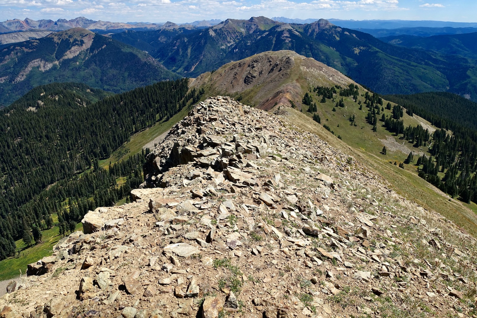
I walked out to the next roller. The Rico Mountains extend east of the Dolores River. Blackhawk Mountain
is the tallest peak in the range. Harts Peak is image-left, Whitecap Mountain is on the right, and Dolores Mountain is low and out front. (THW, photo)

Strong hikers with plenty of daylight and fair weather could tack on Expectation Mountain, shown. My rough calculation there and back is 1.5 miles with 900 feet of gain.
Return to West Fall Creek Trailhead
We bailed southwest for the quickest access to the Calico Trail. Save energy for the two pitches back to the West Fall Creek Trail.

Calico was positively glowing in afternoon light. The peak is so completely crazy and captivating it was hard to look away.

From the head of the West Fall Creek Trail we took a final, affectionate glance at our three peaks. (THW, photo)

Along the pathway downhill backlit daffodil senecio were pulsing electric delight. (THW, photo)

3 comments:
Great hike ! More motorcyclists than we would have liked but still by ourselves most of the time. Thanks for the excellent hike description.
I forgot to say we camped out a couple of nights on sr471. The mosquitos are the worst I have ever seen!
Hi Ed, I'm pleased you enjoyed your hike in the Rico Mountains. Bummer about the mosquitos. We didn't see a one when we were camped there in September. Go figure! Debra
Post a Comment