Essence: Located in the northwest sector of the Santa Catalina Mountains, Catalina State Park is known for a variety of sensational geologic features, most especially those within the upper, cliff-forming unit of Wilderness Suite granite. With a rise of 215 feet, unranked Buster Mountain is often overlooked. And yet the low-elevation summit is irresistible for its views of nearby Pusch Ridge peaks, monoliths, and pinnacles. Many locals return time and again to be immersed in the riveting and sublime splendor. We made several trips to dial in our favorite loop. Climb the
west ridge of Buster, descend on the north ridge, ascend Point
4,223', and return on the standard route. The counterclockwise approach is the most efficient route up Buster and offers continuous vistas. An alternate course is suggested for those who wish to avoid the 20-foot, Class 3 west ridge crux. Photographers are advised to hike in the afternoon for optimal lighting. While the loop utilizes established social trails it takes some navigation savvy to thread together oft braided and faint tracks. Cairns come and go. The hike begins in Catalina State Park and transitions into the Pusch Ridge
Wilderness managed by the Coronado National Forest. See the end of this post for biographical notes on Buster Bailey, the mountain's namesake.
Travel: The park is located at 11570 North Oracle Road, Arizona State Route 77, in the city of Oro Valley north of Tucson. From the entrance station drive 1.5 miles and park in a large lot on the left at the end of the paved road. Vault toilets, water.
Distance and Elevation Gain: 5.5 miles; 2,150 feet
Total Time: 4:30 to 5:30
Difficulty: Social trail, off-trail; navigation moderate; 20-foot, Class 3 crack; no exposure; carry more water than you think you will need; hike in winter months to avoid scorching temperatures and rattlesnakes.
Map: Oro Valley, AZ 7.5' USGS Quad
Latest Date Hiked: December 21, 2022
Catalina State Park: Visit the website for information on fees, hours and campground.
Pusch Ridge Wilderness Bighorn Sheep Closure: It is prohibited to
travel more than 400 feet off designated Forest Service trails from
January 1 through April 30, bighorn sheep lambing season. Buster Mountain is off-limits during that period. Dogs are allowed in the park on leash but not in the wilderness.
References: Frog Mountain Blues, by Charles Bowden. University of Arizona Press, Tucson, 1987.
A Guide to the Geology of Catalina State Park and the Western Santa Catalina Mountains, by John V. Bezy, Arizona Geological Survey, Down-to-Earth No. 12, 2002.
Quote: I fumble around trying to discover what the big rock pile means to the cantankerous old man. He looks at me like I'm a certifiable idiot. "That old mountain," he almost whispers, "that's been the beauty thing of my life." Buster Bailey conversing with Charles Bowden
Quote: I fumble around trying to discover what the big rock pile means to the cantankerous old man. He looks at me like I'm a certifiable idiot. "That old mountain," he almost whispers, "that's been the beauty thing of my life." Buster Bailey conversing with Charles Bowden
From the west ridge of Point 4,262', Buster Mountain reveals its true nature. No, it's not just a humble prominence over-shadowed by the magnificence of Pusch Ridge. Rather, it is a solid dome of granite clothed in a thin mantle of Sonoran flora. (Thomas Holt Ward, photo)

Route: There is more than one approach to Buster Mountain. The counterclockwise loop, depicted with a black line, heads southeast and climbs the west ridge. It descends the north ridge of Buster and climbs Point 4,223' off-trail. There it links with the standard route descending northwest to close the loop on the desert floor. Ridge purists can tackle the west ridge off-trail from Alamo Canyon, the red-line route. The standard route begins by climbing Point 4,223', passes by Buster Spring, and ascends the east ridge of Buster, the blue-line route. To avoid the Class 3 crack, do a clockwise out-and-back.

Established in 1982, Catalina State Park has an elaborate maze of
trails penetrating 5,500 acres renowned for a diverse bird and floral
population. From the north end of the parking lot cross the park road to
access the trailhead, elevation 2,717 feet. The mosaic mural at the trailhead was commissioned by the Friends of Catalina State Park, established in 2012. (THW, photo)

Buster Mountain
Six trails leave from this location. Follow signage for the Birding Trail.

Cross Sutherland Wash roughly a mile upstream of its confluence with Cañada del Oro. Nearing the conclusion of its journey the slow-moving stream consumes a broad flood plain. While this is likely to be a hop-across, it can be a boots-off ford. Buster Mountain is visible throughout the hike. Below, it is above the wader with the white hat. Just past the crossing go right on the Birding Trail. The forest was burned in the 2020 Bighorn Fire yet the birds have returned to entertain with twittering and song.

The Birding Trail loop begins at 0.25 mile under a magnificent tree. A park ranger claims it is a salt cedar. Go left. The trail branches just before one of the numerous east tributaries of
the Sutherland. Take the right
branch and cross the drainage as the hikers pictured below are doing.

Climb a wooden staircase. At the top go right at the fork staying on the main trail even as it bends north and away from our goal.

At the Amy and Rick Wilson bench, 0.5 mile, make a hard left. Step over the line of guiding rocks intended to keep walkers on the main
trail. You are unlikely to see anyone beyond this demarcation line.

The well-established secondary singletrack adheres to an old 4WD road seen on both the Oro Valley topo and CalTopo's Map Builder. The relatively flat trail points due south as it crosses an alluvial fan, an apron of rock debris deposited by streams draining the retreating mountain front.
There is a crucial, easy to miss junction at 1.0 mile. Leave the trail, turning southeast toward the west
ridge of Buster on a tertiary wildcat footpath. We set two cairns marking the junction, shown, but they may not be present. After you get
going the treadway gets slightly more distinct. However, the subtle track is braided with numerous
false forks and loose ends as it punches through desert grassland and mesquite. It can be difficult to distinguish the correct choice among other tracks going off in various
directions. It requires undivided attention to follow sporadic cairns to stay on course.
Note: On our first climb, we blew by the one-mile junction and followed the secondary trail to the rim of Alamo Wash. From there we made for the west ridge, eventually meeting up with the proper wildcat trail. That route is the red-line on the map above. It was typical Pusch Ridge off-trail--ultra brushy. Once we were on the ridge there was some welcome slab-climbing.

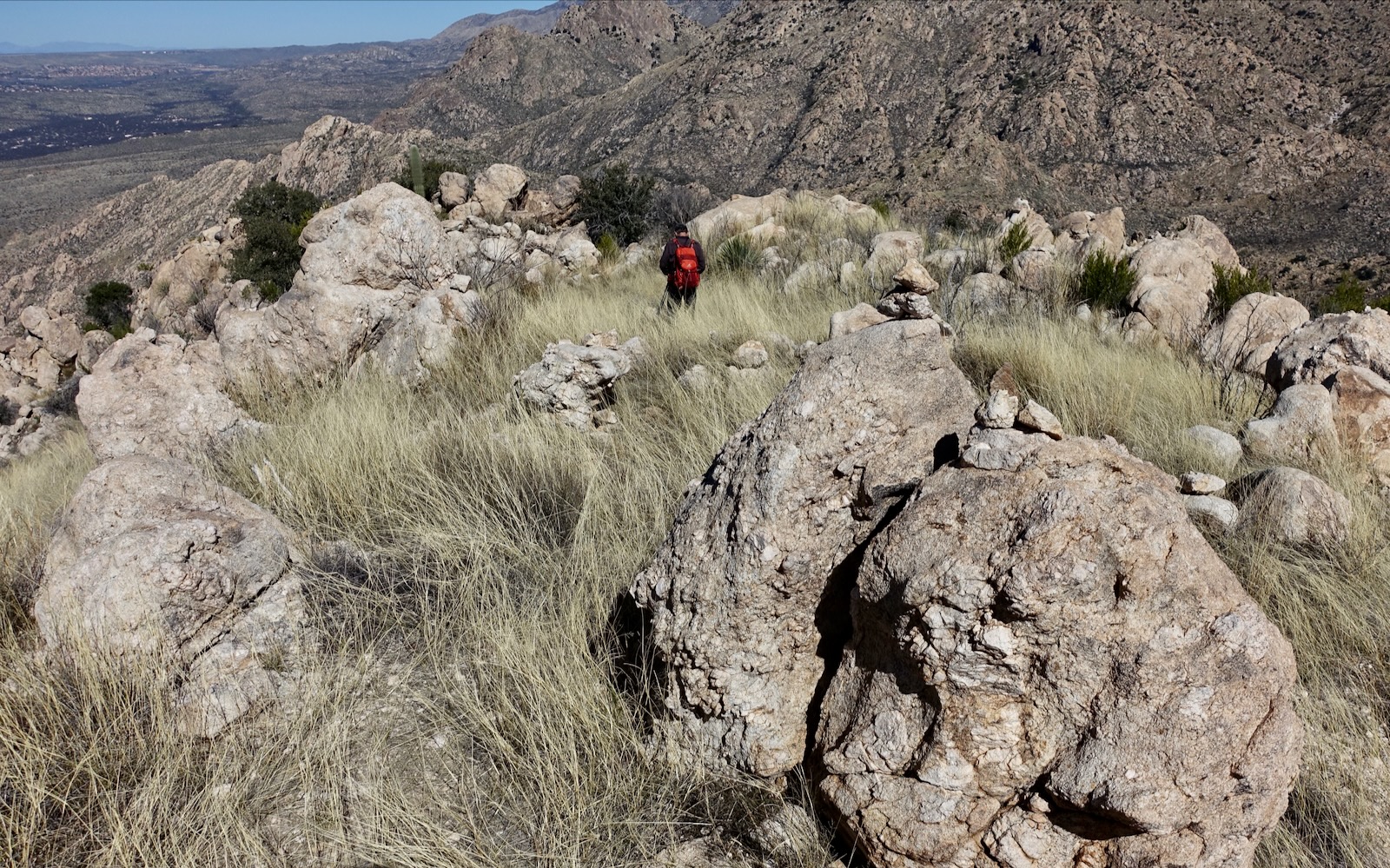
Walk through a field of odd-shaped boulders at 1.2 miles. These boulders are blocks of granite and gneiss fallen from the face of Pusch Ridge and rafted to their present location on the lower slopes by debris flows.
This post is not intended to be a detailed description of the nuances of navigation. However, I will point out primary landmarks through photographs. The image below was snapped just before giving up 40 feet into a minor drainage beyond the saguaro. The trail pops back up and goes into a shallow ravine, passing over the large slab, image-right. Out of the ravine, it then climbs the grass-covered slope and flanks the major outcrop on the south, horizon-image-center. (THW, photo)


Here's a closeup of the slab on the left side of the small ravine, 1.4 miles.

Impressive cairn work guides up the draw and onto another big slab with patches of resurrection moss. Embedded sheets of granite are a great pleasure on the west ridge.

Climb the bulbous bedrock slab shown below. The subsequent incline up the grassy slope is direct and fairly steep. It pitches to the very base of the first west ridge obstacle. (THW, photo)

The trail wraps around the cliff on the south and mounts onto the top of the distinctly red outcrop at 3,700 feet, 1.9 miles. We always take a mid-climb break on the crest of the ridgelet. (THW, photo)

Continuing upward, the west ridge proper is composed of a sleek Catalina gneiss nose, too steep to friction. The trail ascends the swale seen below and then punches up to the ridge from the north. (THW, photo)


Alight on the final ridge with nothing standing in your way of the summit at 3,900 feet, 2.0 miles. The banded prominence to the south is Point 4,262'. Tucked in tighter to the monolithic wall, the views from this summit are even more spectacular than what Buster offers. (THW, photo)

The upper west ridge is the definition of pretty, graced with mature saguaro, pricklypear, sotol, ocotillo, turpentine bush, buckhorn cholla, and brittlebush. (THW, photo)

Plentiful cairns kept us right on the ridgeline. Above us were handsome lines of short-walled stone terraces. Surely we were nearing the crux. I felt some anxiety approaching it for the first time. Was it within my capability? Where exactly is the climber's crack?


The crack proved to be obvious, no mystery there. We were standing beneath it at 4,160 feet, 2.2 miles. (THW, photo)

Turns out, the scramble is pure pleasure. There are plenty of solid hand and foot holds with distinct edges. It's over way too soon. (THW, photo)

For those doing an out-and-back on the west ridge, my partner had no trouble finding the crack on his return. The downclimb is the same degree of difficulty as going up.

The slope graduates from there. Wander among weathered boulders.

Arrive on the south end of the summit ridge. The perspective on Pusch Ridge features is both intimate and utterly wild. I was overcome with feelings of devotion and affection. It is but a gentle walk to the summit. (THW, photo)

Crest Buster Mountain at 2.5 miles after about 1,950 feet of vertical. The rounded and broad summit is topped with boulders and native grasses. The peak register has reams of notebooks and papers. This image looks northwest. Though Buster is visible from a swath of Tucson, it takes a trained eye to pick it out from its over-powering backdrop. (THW, photo)

Southeast, the grandeur and wonder of Pusch Ridge is hard to comprehend or contain. This is why we come here. Starting on the right, this image takes in Pusch Peak, Bighorn Mountain, Table Mountain, Table Tooth, Wolves Teeth, The Molar, Mount Kimball, a triplet of domes, and roiling Point 5,058'. Crags and vertical block faces are so raw their origin as boiling molten masses miles below the Earth's surface makes perfect sense. (THW, photo)

Wilderness, Leviathan, and Solitude domes reside at the head of Alamo Canyon. If you are curious about the classic climbing routes at Leviathan Dome or Solitude Dome, link to Mountain Project. Interestingly, climbers access the domes via Alamo Canyon, beginning on the Birding Trail. (THW, photo)

On our first hike to Buster we took the standard route down the east ridge to the saddle at 4,380 feet. Our route is depicted with a blue line on the map above. There was no trail but it was mellow and easy. Cairns led a bit up the other side and then disappeared as the route curved north. Our intention was to visit Buster Spring and then Point 4,223'. We didn't care for the subsequent side hill trudge characterized by rubble covered in grass with no sign of use. We decided to return and check out the north ridge as an alternate route. The image below shot from Point 4,223' looks back on the north ridge, the east saddle, and side hill.

We climbed a good distance up the streamway, a tributary of Montrose Canyon, but never found Buster Spring. Perhaps the spring was not obvious because the entire draw was flush with water. After abandoning that project we followed a social path with sporadic cairns up to Point 4,223'.

As you ascend, check out the protective mineral rind on the boulders. Bezy, referenced above, calls this case hardening.

North Ridge Descent From Buster to Point 4,223'
The north
ridge descent proved to be a far superior route. Simply go with the flow of the land bearing north and then northeast aiming directly for Point 4,223', image-center. There are no obstacles beyond scattered boulders, oversized sotol,
pricklypear and yucca. It's never too steep. (THW, photo)

At 4,020 feet, we crossed the top of the gneiss slide visible from the base of the mountain. It was a tempting shortcut but prior probes from the bottom were discouraging. The channel becomes snarled with brush, clogged with boulders, and steep.


Looking at the image below, the topo pegs Point 4,223' on the right/east. And perhaps it is! But the higher of the two points is the stone knob on the west. Mount the sweet little pointed hilltop and stand on the cluster of summit boulders at 3.3 miles.

Standard Route Return
The way is well marked by cairn or trail over the course of the descent back to Sutherland Wash. The pink boulders scattered on the ridgetop are embedded with pegmatite, an intrusive plutonic rock with abnormally large, interlocking crystals.
Run out the north ridge to a distinctive wall of boulders, shown, and turn west in front of it on an unmaintained but well-trodden trail.

The footpath throws itself down the hill to a saguaro-topped knoll at 3,400 feet. You'll pass a few modest hoodoos giving it their best shot along the way.

Walk out on an unmistakable swath of granite to see the white slide flowing from the saddle between Point 4,223' and Buster. If you find this undeniable, start from this location, not the top. Be prepared to get torn up bashing through a nearly impenetrable wall of brush.

The trail is less obvious and rubbly in the runout zone back to the east fork of the Sutherland.

The descent trail would be almost
impossible to find going in the opposite direction. There is nothing distinguishable as it
leaves the wash, shown. It materializes a few paces up. Close the loop by the wooden staircase.

While this hike is off-limits during bighorn lambing season, wildflowers are blooming with enthusiasm at Catalina State Park. Springtime blossoms include; Mexican gold poppy, wild hyacinth, cat's eye, fairyduster, creamcup, fleabane daisy, Parry's penstemon, indigo bush, yellow evening primrose, brittlebush, desert anemone, ragged
rock flower, deervetch, prairie verbena, desert chicory, redmaids, owl's
clover, miner's lettuce, monkeyflower, lupine, Texas toadflax, cliff Fendlerbush, and blue-eyed phacelia, shown. (THW, photo)

Buster Bailey
Rather than make an inevitably weak attempt at synthesizing and capturing Buster Bailey's life and character, I'll defer to author Charles Bowden, 1945 - 2014. The following quotes are extracted from the chapter titled "Buster's Mountain," in Frog Mountain Blues.
The blue eyes are going now, the knee's shot, the years are catching up. The hands are strong with thick fingers and wrists, the skin scarred with a lifetime of barbed wire, broken transmissions, and wells that needed fixing.
He came into this country in June of 1927, a sixteen-year-old kid, fresh from around Van Horn, Texas.
The new Catalina State Park spreading against the north side of the range has entombed the ranches he worked and built in the thirties.
He pokes his finger on a map of the north slope and says, "This house
down here where the park is, me and my dad built that in 1927, where
the windmill is. That was the Bailey Ranch."
Up on the mountain, there is a Buster Spring and above Buster Spring
rolls Buster Mountain. For the old man this seems a trifle strange. He
is Buster Bailey, seventy some years old, a man living in a junkyard
with a household bagged at the dump....And now they've gone and made him
into some kind of landmark.
He hates the Forest Service and the backpackers and the wilderness designations that lock up his old stomping ground. He hates everything that has come between him and that mountain.
He punches the harp into his mouth and suddenly a train roars out. First, the engine wheezes as it builds up steam, then the big wheels start slowly rolling, the pace picks up, and the thing screams down the tracks.
I do not speak much at all, but simply listen hour by hour. And what he tells me through songs, quips, snorts, bellers, sighs, and tales is how he came to bond with that big mountain...it still throbs like a beating heart in Buster Bailey's memories.

No comments:
Post a Comment