Essence: It's a little unusual for an unranked prominence to exert a magnetic pull, yet the ziggurat tucked inside Pima Canyon has an undeniable mystique. Evidence on the vertiginous zenith suggests humans have made this very sojourn throughout the ages for ceremonial purposes. Climbers are correct to be wary given ultra steep terrain, loose material, exposure, and demanding scrambling. Navigation is challenging--this description divides the off-trail portion into three sections to assist. The widely used but unofficial name for Point 5,646' was adopted in the early 1980s. I'll save that story for the summit. This hike is most suitable for experienced Pusch Ridge topophiles. The climb is within the Pusch Ridge Wilderness managed by the Coronado National Forest.
Travel: From Tucson, drive north on Oracle Road, AZ-77. Pass Ina
Road and turn right on Magee Road. Go 1.5 miles to the Iris O. Dewhirst
Pima Canyon Trailhead. Or, from Ina Road take Christie Drive north for
1.4 miles and turn
right on Magee. The generous, paved lot is on the right. There is a drinking faucet but no other
facilities.
Distance and Elevation Gain: 9.2 miles (7.8 miles trail, 1.4 miles off-trail); 2,900 feet
Total Time: 7:00 to 9:00
Difficulty: Trail, off-trail; navigation challenging; One Class 4 and one Class 3 pitch; considerable exposure on summit cone; water in Pima Canyon is ephemeral so carry what you will need and hike on a cool day.
Maps: Tucson North; Oro Valley, AZ 7.5' USGS Quads
Date Hiked: December 27, 2022
Pusch Ridge Wilderness Bighorn Sheep Closure: It is prohibited to
travel more than 400 feet off designated Forest Service trails from
January 1 through April 30, bighorn sheep lambing season. Valentine Peak is off-limits during that period. No dogs, ever.
Quote: On the summit, your soul becomes part of the mountain. It makes you feel alive. Nirmal Purja, "14 Peaks: Nothing is Impossible"
Quote: On the summit, your soul becomes part of the mountain. It makes you feel alive. Nirmal Purja, "14 Peaks: Nothing is Impossible"
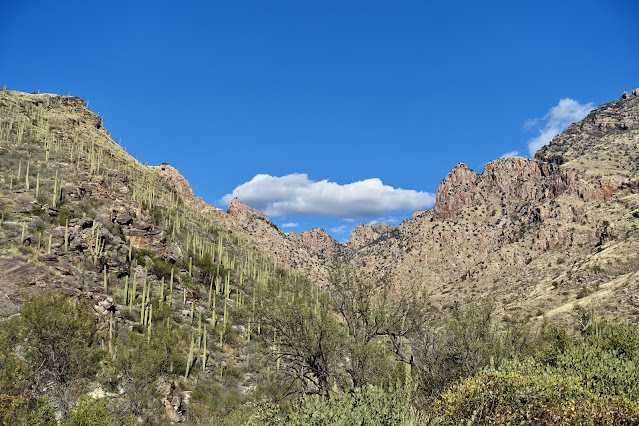
A translucent cloudscape toys with the indomitable object of our quest. The route ascends the slope on the left to the base of the tower. From there, it makes a climbing clockwise corkscrew around the column completing one full circuit to the summit. Note: The images in this post were taken on two successful climbs and one aborted attempt.
(Thomas Holt Ward, photo)
Route: Hike northeast on the Pima Canyon Trail toward Mount Kimball. Leave the trail at 3.9 miles, 4,480 feet, and climb roughly southeast to the summit.
I am assuming that if you are attempting Valentine Peak you have been on the Pima Canyon Trail multiple times so I won't belabor the description. From the Pima Canyon Trailhead, elevation 2,920 feet, the footpath bears northeast toward Mount Kimball. Just past the crested saguaro at half a mile, the trail is enveloped in shade during winter months. Pima Canyon is notoriously brisk; dress accordingly.
At the first stream crossing, 1.1 miles, there was a steady flow of crystalline water in December. Pima Wash generally has a stingy or nonexistent flow so don't count on gathering drinking water. Pass the unmarked turnoff for Rosewood and Prominent points at 1.9 miles. As a good blade should, The Cleaver looks both alluring and intimidating to the northwest.
There is an upcanyon view of Valentine Peak from here on. It makes an impression once you know where to look. I was hiking with a couple of mathematicians. One of them suggested it looked like a prism (such an appealing notion). The other said it was a ziggurat topped with a temple. As we will come to see, he just might be correct.
Pause on any of several creek crossings and you'll see Valentine drawing ever closer.
At 3.0 miles, the footpath crosses a sheet of Catalina Gneiss with five bedrock mortar holes, presumably for grinding corn or other food staples. They hold special significance for the Valentine story so take note. (THW, photo)
A few steps further on, veins of quartz incise a stone slab. The dam (image-center) was constructed in
the 1960s by Arizona Game and Fish. It was intended as a water source
for bighorn sheep and other wildlife. The
east escarpment of Table Mountain is horizon-left and the Wolves Teeth, center. Casual hikers typically turn around at the dam so the trail can be threaded and elusive in places further on. Note: In 2023, Outslope Trail Solutions did a major overhaul of the Pima Canyon and Finger Rock corridor
trails after 20 years of neglect. They realigned, improved the platform, cleared downed
trees, and trimmed brush. (THW, photo)
From the trail there's a good view of the ascent slope leading to the north shoulder of Valentine. The route climbs up through the low cliffband (image-center-left) or flanks it on the south. (THW, photo)
At 3.8 miles, 4,340 feet, the trail crosses Pima Wash and ascends above the canyon floor. This is the departure location for Table Tooth. For Valentine, stay on the trail for it gives us a hand up with more vertical.
Below, monolithic Peak 5,985' (Barrier Tooth), object of lust and denial, takes over the skyline. The hikers are on-trail nearing the departure marker, the hulking boulder just to the right of image-center, 3.9 miles, 4,480 feet.
The off-trail portion of this hike, now a climb, mounts almost 1,200 feet in just 0.7 mile. I present the description in three segments: 1) ascend southeast up the grassy slope riddled with minor cliffbands to the north shoulder; 2) pitch south up the defile into the notch east of the peak; and 3) scramble clockwise up the south side of the summit cone.
Grassy Slope to Shoulder
This first segment is the least demanding of the three. Sure, it's steep but I never felt like I was going to tumble backwards downhill. The slope is broken by Arizona oak and large, scattered boulders. Annoying plants such as shindaggers are happily absent. The image below shows our launch point from the trail. (THW, photo)
The cliffbands are composed mostly of slabs. The brave can skim up the friction pitches. They were too inclined for me to stick. Our track is jagged for a reason. Just weave around to find a course you are comfortable with. In general, the terrain is more forgiving to the south.
A thick mat of moss has adhered to swaths of stone creating small platforms that assist with footing. (THW, photo)
Take your pick negotiating the final cliffband. Turn it into a Class 3 playground, finagle your way on a Class 2+ route, or do an easy walkup on the south. (THW, photo)
As we approached the shoulder the sun arose and moss terraces evolved into an art form. (This is not resurrection moss. If you know the name of this species, please leave a comment.) We arrived on the north shoulder at 4.2 miles, 5,220 feet. This is a comfortable and lovely place to fuel up, look over the terrain, and strategize.
Defile to Notch
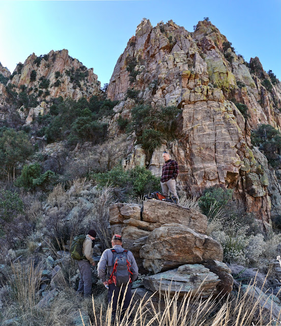
Pictured, three men stand on the shoulder. Valentine is directly above them and the desired notch is to its left. I'm pretty sure most will agree that this next stretch is the most difficult (and annoying) of the three. It's forested and tangled with brush. Saturated soil is slippery. It is ridiculously steep and loose rocks are at the angle of repose. We were ever mindful for the safety of those below. I had to dig down to find sufficient patience to hang in there. (THW, photo)
The image below was shot from further up the Pima Canyon Trail. Valentine is the rightmost of the three towers stepping down from Prominent Point. Viewed from the north, look straight on at the shoulder and climber's defile.
(THW, photo)
As you head south from the shoulder, you are likely to be naturally drawn into the proper gully. Some helpful cairns were present on our climb.
Hold the trajectory and you'll be up against a wall. Transition left/southeast to remain in the trough. Cross a small block field.
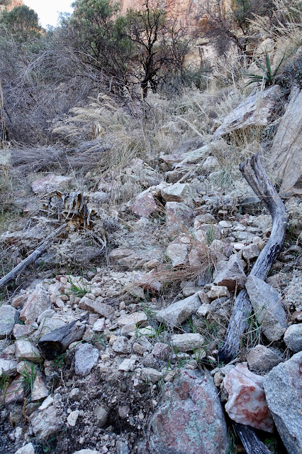
In this image, I am descending and moving back toward the wall. It is critical to nail this on your return or you will be sucked into the wrong drainage. As you can see, it's messy out there. (THW, photo)
Top out abruptly on a micro landing in the notch, a mini saddle, at 4.4 miles, 5,500 feet. My stomach dropped. Surely a dead end. Cliffs squeeze on either side, empty air out front. Now what?
Scramble on Summit Cone to Crest
Valentine Peak is composed of Wilderness Suite Granite and Gneiss. If you've been on Table Tooth, this rock will feel familiar. It is
characterized by vertical joints. Fractures serve as
channels for weathering and erosion. Rock shattered and weaknesses were cut providing us with a circuitous route to the summit on the south side of the mountain. We'll do a rising westward lateral and then pitch north to the summit. All the exposure is amassed in this final segment. Passages are adequate but not generous. Mindful concentration is your best climbing partner. I left my trekking poles in the notch and didn't miss them from here to the summit.
Note: In late 2024 a hiker successfully reached the summit but got off-route almost immediately on his return. He got into trouble in the cliffs and had to be rescued. The lesson here is to look behind you and memorize key markers as you are ascending.
Walk a few feet on a three-foot ledge and then begin scrambling northwest up a near vertical slot. The tree at the bottom is an essential aid to help you get going. It's not a clean scramble. Plants play interference. (THW, photo)
This image looks down on the first pitch. A slip most anywhere on the summit cone could have dire consequences.
At the top of the first slot, climb left about ten feet. Then continue ascending up through trees to a wall. Start the clockwise lateral right against the wall. The agave, pictured, is a good reassurance marker for your downclimb.
This image looks down on the same location. There's some protection from foliage but man, it's exposed. (THW, photo)
Continue up this brushy slot. It leads to the crux. You can climb the 10 to 12-foot, Class 4 pitch either on the right or left. The right is more overhung so we opted for the left option. There are a variety of hand and footholds. The holds are solid but not generous.
Below, my partner is downclimbing. He's on a midway landing, positioning to turn around and spot me.
An eight-inch-wide, ten-foot, Class 3 crack follows immediately. Strong features make upclimbing simple and fun. (However, I came in for an inelegant crash landing on the descent.) From here, it's just 20 brushy feet to the summit.
The small crest at 4.6 miles is so unexpected it's rapturous. The top of the pinnacle is about 25 feet in diameter with a flat, dirt floor. Rock stacks on the periphery render a sense of protection from circling vertical drops.
Scamper up onto the summit boulder.
And there on the very apex resides a twelve-inch deep bedrock mortar hole. Astounding! How can this be? Surely prehistoric people were not grinding corn at this location. I have to speculate that this was a place for preparing a plant or plants used for sacred ritual. It would take many thousands of hours to grind a hole so deep. That is a lot of journeys up this sweet but demanding mountain. I was propelled to a state of ecstatic wonder. And respect. If an archaeologist can weigh in on this matter, please leave a comment.
The headwall of Pima Canyon entices. From the left are Table Tooth, Canine, Barrier Tooth, and The Molar. They are all composed of Wilderness Suite Granite and Gneiss, irresistible and trustworthy rock.
Pusch Peak is the Pima Canyon entrance sentinel on the northwest; Rosewood Point on the southeast. Pima Wash flows into the Rillito River out on the desert floor.
Advancing the timescape a millennium or more, the peak register holds a storyful history scratched on fragile pieces of disintegrating parchment. In October, 1990, a man wrote, "2 days in a row. Brought son up to look for lost wallet. Found it." Desert climbing luminary Bob Martin signed in with five others with the Southern Arizona Hiking Club on Valentine's Day, 1986, shown. A year later a person asked, "Why didn't you warn me Mike...what I was getting into?"
I gratefully learned the origin of the unofficial name from a woman who has been leading SAHC hikes for decades. She said a married couple, Dean and Ethel, were members and guides for SAHC. Ethel had a hike up Point 5,646' scheduled for February 14 in the early 1980s. The day before, Dean climbed the peak and left a box of chocolates on top for her. The club dubbed it Valentine Peak. The name is still in popular use 40-plus years later.
Thank you to my partner Tomás for guiding me so masterfully, and to my dear friend David for having my back.


2 comments:
Debra!
As ever such a lovely day⛰💗
D
Every hike with you and Tomás is a lovely, ultra sweet day. D
Post a Comment