Essence: Quartz Lake is a popular destination for hikers and anglers on the Little Blanco Trail. Once past the "Keyhole," a slim gap in a volcanic wall, this hike stops shy of the lake and pitches west to gain Quartz Ridge, a tundra-clad divide extending from the Keyhole north to Peak 12,390'. Ascend over Point 12,375' to Sand Mountain. Topography is complex with water shedding north via Quartz and Sand creeks to the East Fork of the San Juan River, and southeast into Rio Blanco. Caution: The steep north slopes of the ridge running east from Point 11,225' and the rising traverse under Point 12,260' retain sheets of snow well into mid summer. Crossing them without protection would be dangerous.
Travel: From Pagosa Springs, drive east on US 160. Just east of the San Juan River
bridge, turn south on Hwy 84, signed Chama, New Mexico. In 0.2 mile turn
east on CR 302, Mill Creek Road, and measure distance from there. In
0.3 mile pavement ends. The gravel road is wide, graded, and maintained but it can be troubled with significant
washboard.
Cross over a cattle guard at 4.0 miles. At 6.1 miles, turn right onto
signed Nipple Mountain Road (FSR 665). Cross a cattle guard and the road
narrows a bit. Stay on the main road at 8.3 miles where Echo Canyon
Road #029 turns off to the right. At 9.1 miles, FSR 665 and "24" split.
Take the left branch, staying on FSR 665. Stay on the main road when FSR 735 branches to the right at 12.3 miles. Good clearance and tires are
necessary when the road gets rockier at about 14.4 miles. At 14.6 miles,
the track does a switchback to the left followed by another to the
right. Parking for the Little Blanco Trailhead is on the
right at 15.6 miles. Your mileage may vary. No facilities. Dispersed camping along this road is used by
hunters in autumn. There are clear views of Quartz Ridge and Blackhead Peak from the road.
Distance and Elevation Gain: 9.3 miles; 3,150 feet
Total Time: 6:00 to 7:30
Difficulty: Trail, off-trail; navigation easy; Class 2 with mild exposure
Map: Blackhead Peak, Colorado 7.5' USGS Quad
Date Hiked: July 17, 2023
Total Time: 6:00 to 7:30
Difficulty: Trail, off-trail; navigation easy; Class 2 with mild exposure
Map: Blackhead Peak, Colorado 7.5' USGS Quad
Date Hiked: July 17, 2023
Reference: Pagosa Area Trails, formed in 1998, is a non-profit trail advocacy organization dedicated to planning, construction, maintenance, and promotion of local trails within the Pagosa Springs area of the San Juan National
Forest. Currently, their main focus is addressing the crisis due to severe spruce beetle die-off and downfall.
Quote: It is spring again. The earth is like a child that knows poems by heart.
Rainer Maria Rilke
Rainer Maria Rilke
This panorama spans the length of Quartz Ridge: Peak 12,390' (image-left), Point 12,310', Sand Mountain, Point 12,375', the Keyhole, Point 12,260', Nipple Mountain, and Blackhead Peak. The Little Blanco Trail makes for a fortuitous gap in the ridge and then bears north to its terminus at Quartz Lake. (Thomas Holt Ward, photo)

Route: Bear northeast on the Little Blanco Trail to the ridgeline east of Point 11,225'. Hike east through the Keyhole. Leave the trail at the glaciated bench overview and ascend west to gain Quartz Ridge. Hike over Point 12,375' and then north to Sand Mountain. Return as you came.

The trailhead for the Little Blanco Trail, elevation 9,960 feet, is across the road from parking. The trail register was full upon our arrival.


Initial steps are southwest but the footpath soon switches to the northeast and holds that bearing to the ridge east of Point 11,225'. The dirt treadway feels like a very old trail. Some trip reports imply the trail was once difficult to trace but in 2023 it was pounded and obvious as far as our turnoff and we could see it continuing on to the lake quite forcefully. The consistent, mellow grade is sustained with switchbacks up a south-facing slope, shady in the morning, sunny in the afternoon. The old conifer forest, a mix of spruce and fir, has been completely decimated by beetle kill. Younger trees have been spared. After a heavy winter in 2023, wildflowers were threatening to obliterate the trail. We plowed on through. (THW, photo)

Aspen groves are thriving above 10,400 feet, and we paused to listen to the conversation of leaves. We could see unmistakable Squaretop Mountain and Blackhead Peak to the south. We scared up a solitary juvenile ptarmigan, or perhaps we simply couldn't see its companions. Little sunflowers pointed east according to their nature. (THW, photo)

Top a southwest-facing interior ridge at 1.1 miles, 10,720 feet. The trail threads over and back, intentionally staying west of a large ravine filled with volcanic rubble. At 1.6 miles, 11,100 feet, the path heads and crosses the defile to gain the ridgetop and enter the South San Juan Wilderness. (THW, photo)

The trail turns east and takes aim on the Keyhole. At 2.0 miles the visual field opens to span the length of Quartz Ridge as seen in the opening image. (THW, photo)

The Little Blanco Trail is nothing short of an engineering marvel. It doggedly adjusts to the restricted and convoluted topography. The ridge constricts and falls off dramatically on both sides. Yes, it is narrow but the trail platform is flat and generous. Our timing in mid-July was good. A week earlier we wouldn't have gotten past the cornices encroaching on the track.
Below, Squaretop Mountain and Katie's Peak are framed by breccia spires. All the peaks in the area are volcanic. Most of the rock was exploded
out of calderas in the vicinity. Because the eruptions were so
violent, lots of preexisting rock fractured and the rubble became
incorporated in the massive deposits of welded debris--volcanic
breccia. (THW, photo)
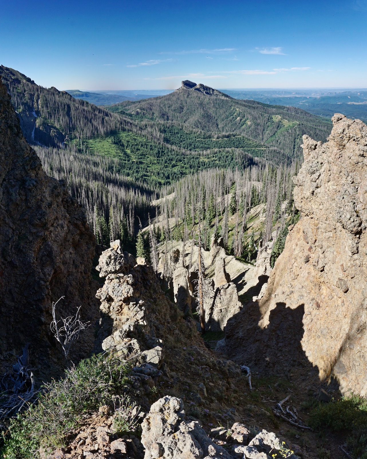
We first studied Point 12,260', image-right, from Blackhead Peak. Climbing it was the primary goal of this hike. We figured we could pitch up the northwest ridge, shown. It looked good on the map! However, we found it well armored and intimidating (not fun) so we abandoned that approach hoping we'd find an alternative route on the other side of the Keyhole, aka "Window." Look carefully at the image and you'll see the trail traversing up the west slope.

At 2.7 miles, 11,700 feet, the track pitches up and makes for the Keyhole. The treadway is plenty wide and doesn't suffer sidehill slough-off. (THW, photo)

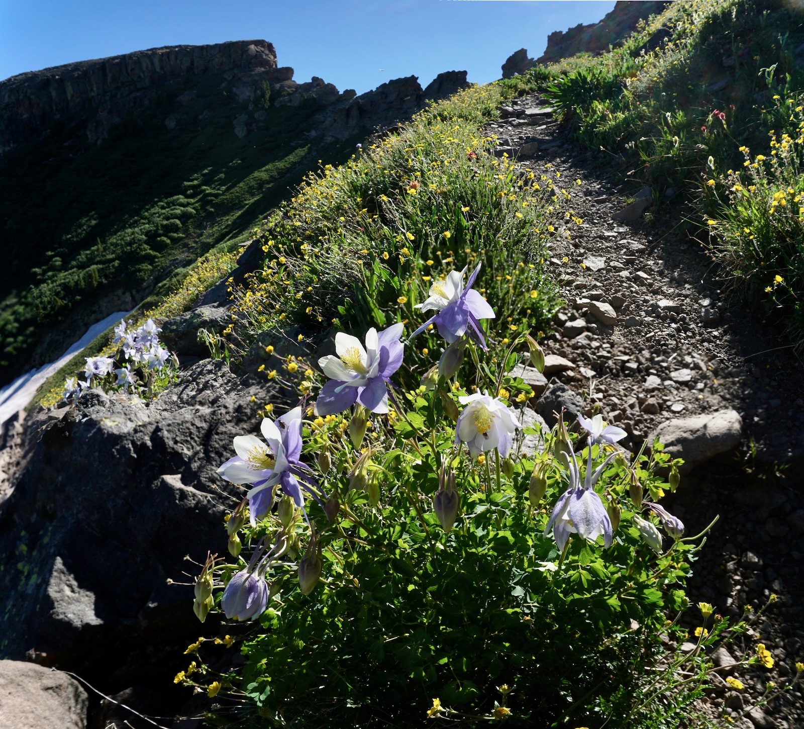
Flowers in the alpine were as diverse and abundant as those in the lower reaches. (THW, photo)
We dodged two snowfields lingering on the north-facing slope by cutting down, around, and back up. (THW, photo)

Given the degree of pitch, we would have needed an ice ax to cut directly across. (THW, photo)

An explosively purple Parry's Primrose clung to the moist mountainside. (THW, photo)

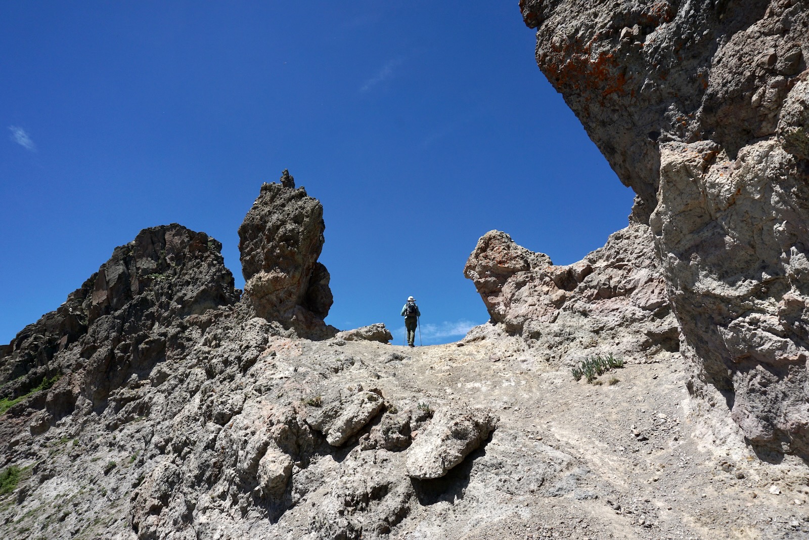
The path is cleaved into the breccia wall as it approaches the slender break in Quartz Ridge. (THW, photo)

Stand in the Keyhole at 3.0 miles, 12,000 feet. Through the Window a bold new world of peaks tops the Continental Divide. Rising above all the crests in the South San Juan Mountains is Summit Peak, 13,300', the highpoint in Archuleta
County. Our revised plan was to climb Point 12,375', Sand Mountain, and Peak 12,390'. And while we were standing on the terminus of the south ridge of Point 12,375', it was readily
apparent that we were not going to be clambering up onto Quartz Ridge
from there so we continued on the trail. (THW, photo)

As you pass through to the east side, the trail hugs the breccia wall. Initial steps are on slick, resistant soil so watch your footing.

Below, I'm examining Point 12,260', image-center, for a route up from this side. Nothing appealed and we abandoned that plan. (THW, photo)

Overlook a captivating glacially scoured bench at 3.3 miles, 12,080 feet. It reminded me of landscapes in the Sierra Nevada Mountains and we agreed to explore the flat on our return. (THW, photo)

We cut west and ascended a fell field with large embedded boulders in tundra tinted with tiny purple violets.

Arrive on the broad, flat-topped ridge at 12,220 feet. A thin veil of soil covers stone giving the impression of a massive swath of tundra much like what we saw on the approach to neighboring Blackhead Peak. Below, I'm starting up the south ridge of Point 12,375'. (THW, photo)

The terrain necks down into a delightful ridge climb--thin but never scary. Ridgetop boulders are easily dodged on the west. (THW, photo)

An exceeding large cairn marks the vast and softly curved summit of Point 12,375' at 3.8 miles. Royal-blue Quartz Lake nestled in timber rests on an extensive bench that falls off radically into the Quartz Creek trench.
Looking at the image below, we intended to climb over Sand Mountain (image-left) and continue out the ridge to Peak 12,390'. We descended into the 12,220-foot saddle. As we started up Sand Mountain the terrain sloped off steadily to the west with a sheer, vertical drop to the east.

Approaching the mountain the powerful stone escarpment is arced. Then it straightens out with a statement of raw strength. The ridge narrows on the final climb to the crest with mild exposure.

This image shoots back at Point 12,375'. Sand Mountain is so welcoming I felt as if I was walking through dreamland. (THW, photo)

The roundoff at 4.4 miles is guaranteed to induce tundra euphoria. My wildest imaginings could not conjure this grandeur. There was no evidence of sand anywhere on the mountain. My partner suggested a better name would be Airport Peak because, "A balloon-tired Cub could do five touch and goes on the top of this mountain." Curiously, there were multiple steel-gray
rebars sticking out of the ground and from cement footers. A steel plate
once anchored a structure. If you know the story behind this mystery please leave a comment. The peak register was placed in August, 2020. (THW, photo)

It looked like we could just keep tundra-walking over Point 12,310' to Peak 12,390' at the far end of Quartz Ridge so off we went. (The most northerly peak on Quartz Ridge was elevated to 12,401 feet by LiDAR.) We saw a herd of elk with scampering calves on a snow field on the east side of the ridge, image-center.

Heading north, the vast tundra tabletop pinched to nothingness just 0.2 from the summit. We searched for a bypass on the west but that proved to be a disappointing impossibility. Cliffed out, we retreated.


We searched all the while for a place to cut down into the Quartz Lake basin but snow fields flush against the east-facing cliff wall prohibited passage until we were back on the south side of Point 12,375'. We retraced our steps to the glaciated bench overview. We took a few steps down onto the flat, perhaps the prettiest place on the entire hike. Snow on the shallow pond was sinking beneath the surface, its outlet brightly tinkling. Glacial erratics rested on ice-polished slabs of stone. For a moment I was lost on timeless Earth envisioning ice scraping and scouring this very spot!
(THW, photo)

We could see a plausible route from the Quartz Lake basin up onto the ridge south of Point 12,310'. But it was a hot day and even with a gallon each we were running out of fluids. So we returned to the Keyhole. (THW, photo)

This landscape was born of both fire and ice. (THW, photo)
The Keyhole is located at the apex of a massive arc that takes in Quartz Ridge and Coal Benchmark, 11,905', shown. The water carrier heading north is Sand Creek.

We passed a brilliant and dazzling scarlet gilia on our way downhill. (THW, photo)

After a heavy and prolonged winter wildflowers were seemingly all blooming at once. We identified 60 species listed here in order of appearance:
purple vetch, mountain parsley, yarrow, orange sneezeweed, Richardson's geranium, peavine,
bluebell, strawberry, Indian paintbrush, scarlet gilia, snowberry, cow parsnip, osha,
little sunflower, fern leaf and parrot beak lousewort, corn husk lily, fitweed, dusky penstemon, delphinium, brookcress,
caraway, elderberry, baneberry, current, harebell, wood's rose, heart leaf arnica,
western valerian, globe flower, marsh marigold, columbine, clover, black
tipped senecio, alumroot, king's crown, Jacob's ladder, Coulter's erigeron,
Parry's primrose, snowball saxifrage, alpine avens, minuartia,
purple violet, alpine willow, sulfur paintbrush, moss
campion, candle anemone, sky pilot, dotted saxifrage, purple fringe,
potentilla, old man of the mountain, pussy toes, American bistort,
Colorado ragwort, phlox, ten petal buttercup, and snow buttercup.

No comments:
Post a Comment