Essence: Color your world red. Red Mountain No. 1 is the easternmost peak in a tightly packed trio
between Red Mountain Pass on the west and Gladstone on the east. In
2022, we traversed from Red 3 to Corkscrew Pass on our way to Red 1 when we got turned back by threatening weather. There are two approaches to Red 1. For the short, quick, solid red route, climb the south face rockpile from Corkscrew Pass. This makes perfect sense if you are climbing all three Reds in one long day. If you possess a serious 4WD vehicle, you may climb the east ridge from Gray Copper Gulch, descend the south face, and return on the Corkscrew Pass Road. The circuit will introduce you to the mountain's dual personality--tundra-induced harmony and explosive brilliance. Views are mesmerizing. Post hike, explore tarn-riddled Gray Copper Gulch. The summit is within the Uncompahgre National Forest. The east end of the loop is on BLM property. Based on new, more accurate measurement technology, LiDAR, Red 1 has been
elevated to 12,598 feet with a rise of 649 feet.
Travel: From Silverton, in a vehicle with 4WD low and high clearance, drive up the main drag. Measure from the junction of Greene Street and San Juan County Road 2. Stay on Greene Street, passing a sign for Silverton Mountain ski area and wind up the hill past Memorial Park. The road transitions to CR 110 and dirt at 0.8 mile. Drive north up the Cement Creek corridor. Pass Silverton Mountain at 5.7 miles. The road splits in Gladstone at 6.4 miles. Take the left branch toward Corkscrew Pass and Hurricane Pass, CR 10. The road deteriorates immediately to a serious 4WD track. It is an ultra narrow, steep shelf with limited passing opportunities for the next 1.5 miles. (Travel early--most 4 wheelers are driving west to east.) Crank a hairpin left onto unsigned CR 11, Corkscrew Pass Road. Climb another 0.15 mile hanging out over the sky to a sharp right onto the Gray Copper Gulch jeep track. In 0.15 mile we found a pullout for one vehicle on the right. There are other limited opportunities further out the road.
Travel: From Silverton, in a vehicle with 4WD low and high clearance, drive up the main drag. Measure from the junction of Greene Street and San Juan County Road 2. Stay on Greene Street, passing a sign for Silverton Mountain ski area and wind up the hill past Memorial Park. The road transitions to CR 110 and dirt at 0.8 mile. Drive north up the Cement Creek corridor. Pass Silverton Mountain at 5.7 miles. The road splits in Gladstone at 6.4 miles. Take the left branch toward Corkscrew Pass and Hurricane Pass, CR 10. The road deteriorates immediately to a serious 4WD track. It is an ultra narrow, steep shelf with limited passing opportunities for the next 1.5 miles. (Travel early--most 4 wheelers are driving west to east.) Crank a hairpin left onto unsigned CR 11, Corkscrew Pass Road. Climb another 0.15 mile hanging out over the sky to a sharp right onto the Gray Copper Gulch jeep track. In 0.15 mile we found a pullout for one vehicle on the right. There are other limited opportunities further out the road.
Distance and Elevation Gain: 2.7 miles; 1,000 feet
Total Time: 2:00 to 3:00 for the circuit
Difficulty: off-trail, Jeep track; navigation moderate; Class 2 with no exposure
Total Time: 2:00 to 3:00 for the circuit
Difficulty: off-trail, Jeep track; navigation moderate; Class 2 with no exposure
Reference: Please link to Nader's SummitPost entry for his captivating essay on Red 1.
Map: Ironton, Colorado 7.5' USGS Quad
Date Hiked: July 3, 2023
Quote: Nature always wears the color of the spirit. Ralph Waldo Emerson
Map: Ironton, Colorado 7.5' USGS Quad
Date Hiked: July 3, 2023
Quote: Nature always wears the color of the spirit. Ralph Waldo Emerson
The Red Mountains are on the northwest rim of the Silverton Caldera. Successive volcanic explosions within the San Juan Volcanic Field racked the range from 35 to 28 million years ago. Invading hot mineral solutions painted the volcanic rock with great swatches of red and ochre oxidation. The lineup of 13ers seen below is east of the Cement Creek corridor. (Thomas Holt Ward, photo)

Route: This regional map is intended to illustrate the spacial relationship of the three Reds. The circuit described begins in Gray Copper Gulch and bears west up the east ridge of Red 1. Descend the south face to Corkscrew Pass. Walk east down CR 11 and cut back north into the Gulch. The blue line is an optional walk down the Jeep track in the Gulch to a locked gate.

We found space for one vehicle just shy of the highpoint in Gray Copper Gulch, elevation 11,740 feet. We were directly west of Point 11,497', surely mislabeled on the Ironton topo. Standard extrapolation puts it at approximately 11,780 feet. The winter of 2023 was heavy and I am standing beside one of the many ephemeral ponds collecting snowmelt in July. The evolving view of nearby peaks from the east ridge offers a strong incentive for this approach. (THW, photo)

The east ridge is not well-defined at its base so where you initiate the hike isn't critical. We ascended right from our pullout. With Red 1 in clear view, summit relief is less that 900 vertical feet.

There is a circular parking area another tenth of a mile out the Gulch, image-right.


Having rummaged around in the Reds over the years, always from the west, we were immediately enthralled with the verdant world on the lower east ridge. Scattered stands of timber lingered just below tree limit. Patches of snow contributed to ponds cradled in swaths of tundra. Wildflowers provided vivid color. It was simply glorious.
There was some minor unavoidable undulating. Where it was steep, the footing was good. Heading generally west, we climbed to the left of the outcrop, image-center.

All approaches are gathered together at 0.5 mile, 12,000 feet, on a cairn-topped mound. The ridge is clearly defined from there.

Nearby to the south, thrusting abruptly from Velocity Basin are Velocity (left) and Storm peaks. Though absent red hues, they are composed of San Juan explosive volcanics having been birthed in the same fiery renaissance that propelled the San Juan Mountains out from the depths of a shallow seaway. (THW, photo)

The peak lives up to its name. Color penetrates deeply into the mountain and into all those who walk in its presence. This image looks down on Corkscrew Pass. Even on the busiest weekends you are unlikely to have company on the Reds. (THW, photo)

The talus is filled with wonders. Most astonishing is the Silverton wallflower, shown. The only place on Earth where the yellow mustard is painted purple is in surrounds very near the town of Silverton. Alpine wildflowers have to be opportunistic to survive. Once liberated from snow they seemingly all bloom within minutes. Up high we saw alp lily, moss campion, old man of the mountain, snowball saxifrage, alpine willow, deep rooted spring beauty, alpine avens, pygmy bitterroot, alpine sandwort, candle anemone, candytuft, purple violet, columbine, kittentail, king's crown, and more! Smell the alpine fresh. (THW, photo)

Medium caliber talus transitions to chipped stone. The ridge is obstacle free and comfortably wide clear to the summit. (THW, photo)

We walked beside the remains of a cornice line. The incline eases at 12,540 feet. Take note of the cairn marking the social trail down the south face. The false peak at 1.0 mile is actually the east end of the summit ridge.

Keep going! Walk through an extruded blob of dark andesite boulders.

Arrive on Red Mountain No. 1 after just 1.1 miles of blissful hiking. The volume of snow was staggering but prevailing nevertheless was the Red Mountain sunburst of bedazzling color. It takes awhile to assimilate the westward view. Immediately south of Red 3 is McMillan Peak. In the dip between the two, at skyline is the tallest mountain in the Ice Lake group, Vermilion Peak. The most recent LiDAR measurement has elevated it further to 13,909 feet! To the right of Red 3 is Three Needles, a challenge for any mountaineer. Off image but seen from this vantage point is Mount Sneffles and its spicy companions.

Below, my partner is standing on the first cone out the north ridge. There are three numbered points but the mile-long ridge was troubled with cornices in all the wrong places so we didn't attempt to make the run out there.

Eastward, Brown Mountain encloses the Gulch. For the curious, a friend climbed from the Gulch to the Duco Benchmark, 13,339'. Further east are Hurricane and Hanson peaks which we climbed in a circuit with California Mountain.

Looking south Pigeon and Turret peaks show off unmistakable profiles east of the Animas River canyon in the Needle Mountains. Grand Turk and Sultan Mountain are landmarks above the town of Silverton. The next objective on this circuit is Corkscrew Pass, just 0.4 mile away with less than a 400-foot drop.

South Face Descent
Retrace your steps for 0.15 mile going back over the east end of the summit ridge. Other important mountains in the vicinity are Bonita, Emery, and Proposal peaks framing Minnehaha Basin, image-left.


Watch for a subtle social trail cutting southwest at about 12,540 feet. The footing is decent in red, granular soil.

There is one obvious switchback cutting south-southeast into slightly larger caliber rock. We lost the trail in a snow field, or maybe it simply disappeared. No matter. We simply pointed south and finished the descent between two ponds on top of Corkscrew Pass.

Uniform stone and cerulean blue sky meet to create a distinct horizon line.

Pond and snow rest in stillness on the pass platform.

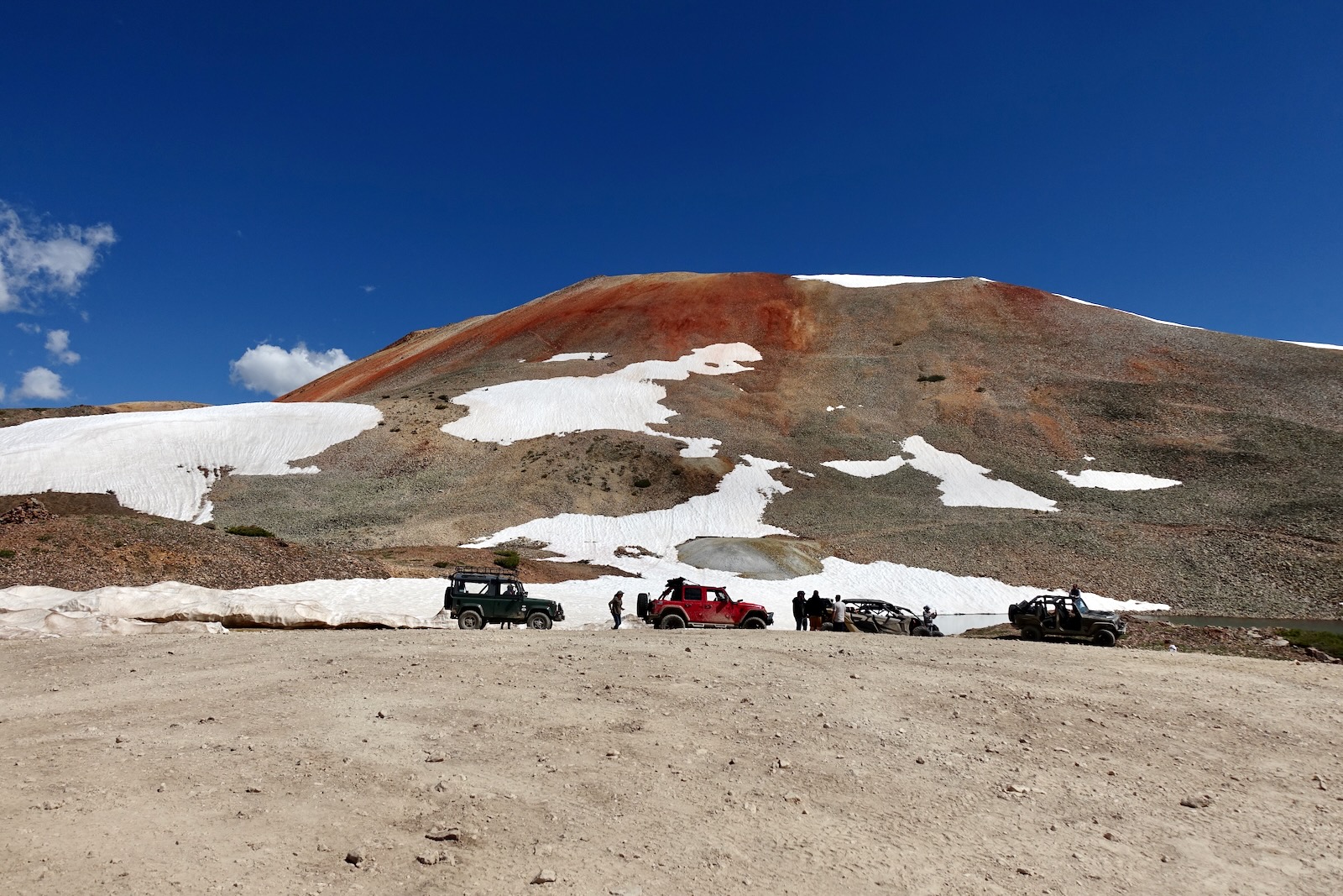
Arrive on Corkscrew Pass, elevation 12,220 feet, at 1.5 miles. We were there over the July 4th weekend which can portend madness in and around Silverton. But the traffic was light, the 4 wheelers were polite and giddy with happiness and somehow the beauty remained untamed. The image below is the most common perspective on Red 1. Look carefully and you'll see the trail moving up out of the snow patch.
A couple of local skiers made a few early turns and were heading west toward home.

We walked east down CR 11 for one mile taking in all the familiar landmarks contributing to Cement Creek, a major drainageway. The masses of 13ers put the relatively low-slung Red Mountains into perspective. There's a sign for the Alpine Loop and a maintained outhouse at the Uncompahgre National Forest and BLM boundary.

Leave CR 11 at 2.6 miles and crank a left on the Gray Copper Gulch Road. Grind up the hill about 0.1 mile to your vehicle.
Gray Copper Gulch
There is much to explore in the lush basin. We were completely blown away. The circular parking area mentioned previously overlooks tarns, red water reflecting the north ridge wall of Red 1.

Terraced tarns on the tableland were pools of mirrors. Rills meandered through the tundra.

We turned around at the locked gate 0.7 mile from parking and wandered aimlessly up assorted little hillocks at the foot of Brown Mountain. Plants big and small were living in harmony with each other, water, and
stone. There was a sense of profound perfection and peacefulness. We finished on (incorrectly numbered) Point 12,497', pictured, and slipped back to our vehicle.

No comments:
Post a Comment