Essence: With a prominence of 4,094 feet, Mount Taylor is an eminent landmark visible to travelers on Interstate-40 between Thoreau and Albuquerque. The impeccable Gooseberry Springs Trail ascends gently and steadily through a park-like forest. Emerge onto grassy slopes that flow out from the mountaintop in luxurious waves. Views from the isolated summit are boundless. The Navajo people honor the peak as one of the Four Navajo Sacred Mountains
marking the boundary of their homeland. Known to them as "Tsoozil," or
Turquoise, Taylor is the sacred Mountain of the South. Hesperus Mountain marks
the North corner; Blanca Peak, the East; and Humphreys Peak, the West. Mount Taylor is a gentle giant with violent origins. It is a composite stratovolcano that was active 3.3 to 1.5 million years
ago. The summit is the highest point on the west rim of an east-facing amphitheater. It is part of a larger northeast-trending volcanic field. Hikers confident in their off-trail navigation skills can consider an alternate descent route. The San Mateo Mountains are managed by Cibola National Forest.
Travel: Mount Taylor is northeast of Grants, New Mexico. Exit in Grants and locate NM-547, Lobo Canyon Road. The paved road bears northeast, passes two prisons, and enters Cibola National Forest. Wind uphill through grassland and volcanic features. The Coal Mine Campground, mile marker 10.8, has pit toilets and picnic tables, but no water. At mile marker 13.1, turn right on FSR 193. There is dispersed camping off the maintained gravel road. The surface is prone to washboard and the upper road can be muddy when wet. The Gooseberry Springs Trailhead is 4.9 miles up FSR 193. There is ample parking on the right. No facilities.
Distance and Elevation Gain: 6.6 miles; 2,100 feet
Total Time: 3:00 to 4:30
Difficulty: Trail; navigation easy; Class 1 with no exposure. Off-trail ridge return is Class 2; navigation moderate.
Maps: Lobo Springs; Mount Taylor, New Mexico 7.5' USGS Quads
Date Hiked: October 4, 2023
Quote: I have been to the end of the earth, I have been to the end of the waters, I have been to the end of the sky, I have been to the end of the mountains, I have found none that are not my friends. Navajo Proverb
Blue Mountain of the South is visible from four cardinal directions. This image was shot on the roll from NM 605 northwest of Grants.

Route: The Gooseberry Springs Trail, shown with a black line, ascends northeast to the south ridge of Mount Taylor. From there the trail bears north to the summit. The optional off-trail, blue-line descent route follows a broad ridge southwest, rejoining the standard route half a mile from the trailhead. Note: the Lobo Springs and Mount Taylor topo maps have 20-foot contour intervals.

The Gooseberry Springs Trail #77 begins across the road from the parking lot, elevation 9,270 feet.

The smooth dirt footpath bears northeast through a quiet and peaceful woodland. Aspen, young and mature, manage to hang on in the climax ponderosa forest. Pine needles soften the trail. Volcanic boulders are strewn about. Grasses light the forest floor. It is October and the mountain's wildflowers have gone to seed. (Thomas Holt Ward, photo)

At half a mile, 9,520 feet, cross over the subtle remnants of a volcanic dike on a southwest trending ridge. If you intend to return on the alternate off-trail route, this is where you will rejoin the trail. (See map above.) This is just before the slight drop into "Gooseberry Draw." Two springs in the draw contribute to a stream that runs west into Lobo Canyon. It was dry when we crossed on two sturdy log planks placed by the New Mexico Youth Conservation Corps.

There are a number of trails in the draw and it can be a little confusing. Locate an old two-track going south briefly. Hook back north at a gateway cairn at 0.7 mile. Your confirmation is a sign, "Mt. Taylor 2." Actually, the summit is more like 2.6 miles afar.

The trail parallels the draw on the south side. Hikers are treated to a sweet little aspen grove at 9,600 feet. Aspen thrive best in sunny locations so if you find them mixed with other timber, eventually the conifer are going to take over. These young aspen are giving it their best shot.

Wiggle through a zig zag gate at a fenceline at 1.2 miles. This whole affair looked new and I had to stop and admire the truly expert and craftful wiring job. The forest thins at 10,000 feet. The ponderosa are atypically squat on the southwest slopes of the mountain. Multiple abandoned tracks ascend the hillside. Do your best to stay on the main trail.

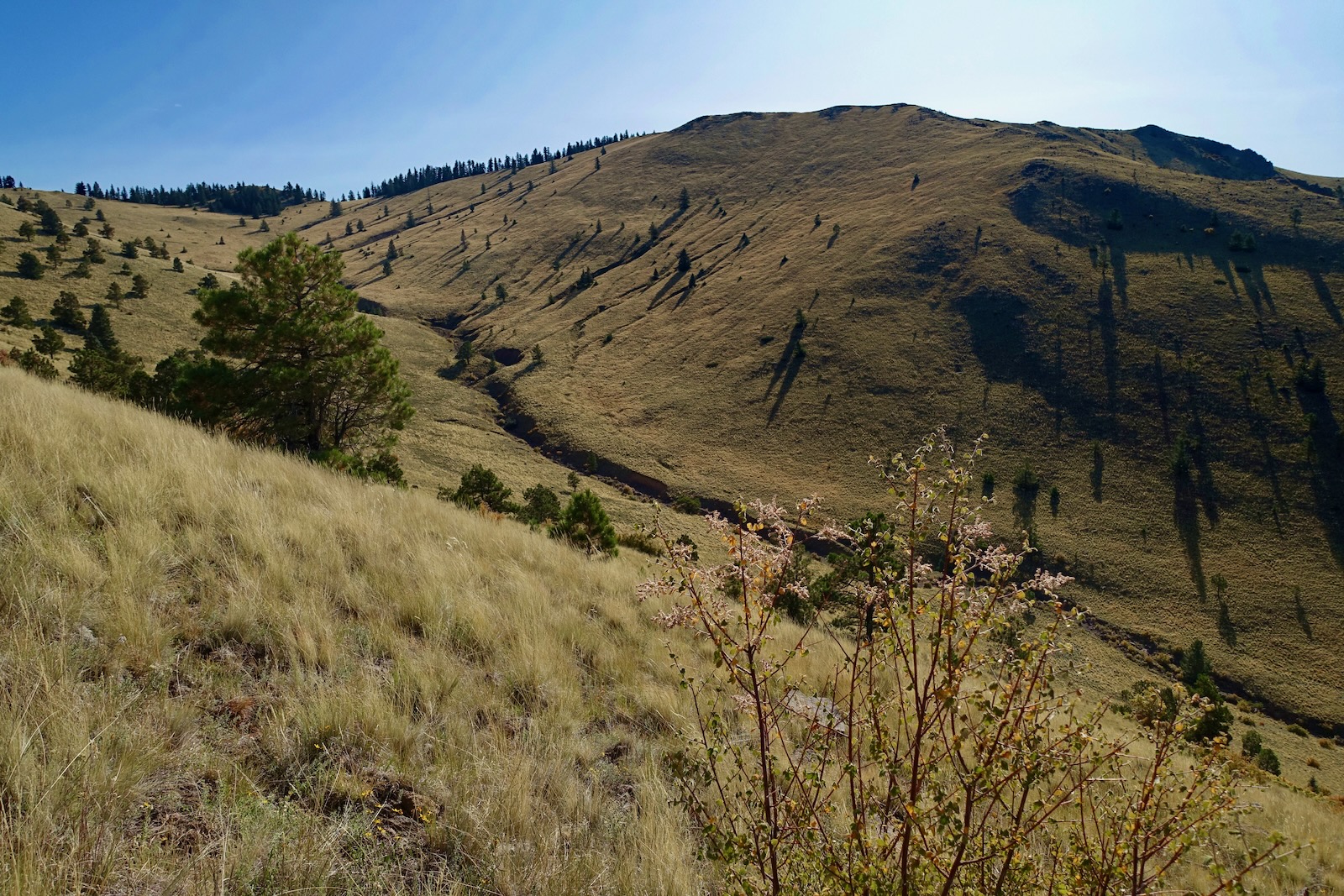
Approach the south ridge on the immense grassy southern slope seen from great distances on regional roads. The crest of the profoundly silent mountain is toward the left side of the image below.

Gain the south ridge in just under two miles, 10,350 feet. The vista from the isolated mountain is imponderable to the south. The wide-open country sharply contrasts with mountain climbing in Colorado. In our home state, stand on one peak and you are surrounded by countless more.

The trail rolls over to the east side of the broad ridge. (THW, photo)

Deep into autumn, trees across Rinconada Canyon cast lengthy conical shadows. Rinconada Creek flows south past I-40.
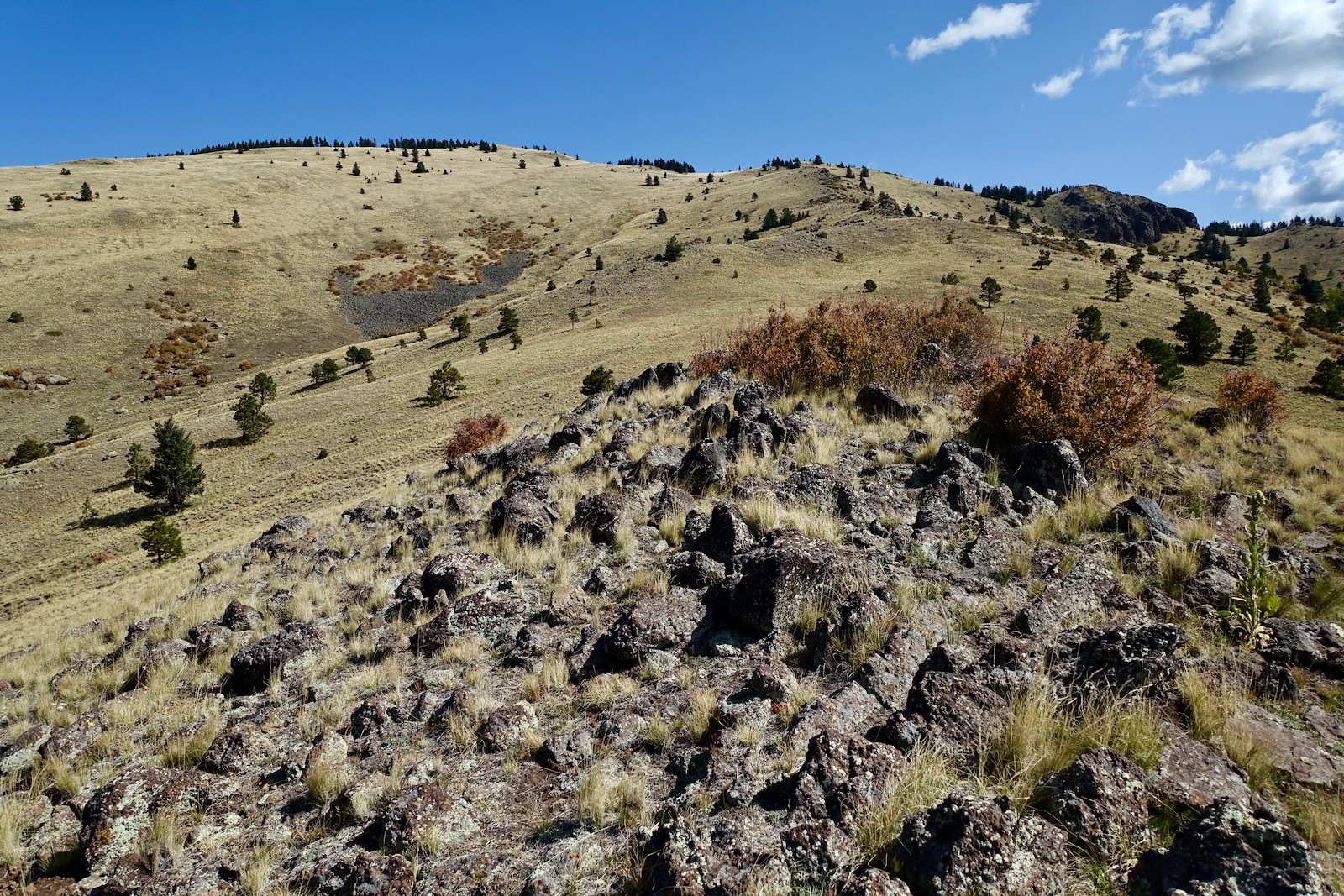
Two very different facets of this mountain show themselves--softened slopes and sculpted volcanic outcrops.

The smooth footpath crosses over to the south side of the ridge at 10,520 feet to bypass great mounds and spires of stone.


The outcrop seen below is probably composed of trachyandesite lava which makes up 65% of the Mount Taylor cone. Most of the basalt in the Mount Taylor Volcanic Field erupted from vents after the
cone formed, spreading boulders out over erosion
surfaces.

Meanwhile, the treadway is a furrow set into tall, golden grasses. At 3.0 miles, 11,040 feet, pass the optional descent ridge.

Open and close the gate in a fenceline. As the summit approaches cross an old road, staying on the cairned single track. Arrive on the peak at 3.3 miles only to be greeted by a playful sign. (THW, photo)

Reference Mark No. 2 placed by the Geologic Survey in 1945 is present. However, the Taylor Benchmark disk it points to has been removed.

There is an inexplicable circular depression on the expansive summit functioning as a wind shelter with good sitting rocks. The peak register is fastened to the back of the peak sign and the whole affair is secured to a steel wheel filled with cemented rocks. (THW, photo)

The image below looks out over the volcanic amphitheater from the highest point on the rim. The cylindrical cone in the center of this image is Peak 10,607' with a rise of 357 feet.


Southwest, the San Mateo Mountains in Cibola National Forest extend to the outskirts of Grants. And into the blue distance is the interface of earth and sky.

On the summit we ran into a couple of hikers who drove up La Mosca Canyon and parked in the saddle between the La Mosca Lookout and Mount Taylor. They said it was a quick trail hike to the summit. Their red vehicle is visible at the base of this image. To get a better look, we walked a short distance out to a knob north of the summit (passing a campsite on the mountaintop). La Mosca Lookout, 11,036' has a prominence of 471 feet but given all the communication towers on the summit, it didn't tempt us. However, it would be simple to combine the two ranked peaks. The fire lookout was erected in 1939. Cabezon Peak (image-right) is a 2,000-foot-tall volcanic plug, the largest of several dozen monoliths called the
Rio Puerco Necks. Rising above the Rio Puerco Valley floor, they are
some of the best-preserved examples of volcanic necks in the world. (THW, photo)

Trail hikers should retrace their steps to the trailhead. We wanted to experience more of the mountain so we left the trail at 11,040 feet and headed down a rounded ridgeline bearing southwest. (We started in the stand of conifers seen below.) The off-trail route saved 0.7 mile but took as much, or even more time
as returning on the trail. This route is for hikers experienced in off-trail navigation.

From the ridge we looked over to the standard route.

We wound between well-seated basalt boulders. When I'm off-trail I get a better sense of the mountain's true essence. It was immediately exhilarating.

We walked on the remnants of an eroded dike. The rocks were coated in pale lichen so clearly they've been sitting in one place for a long time.

It could not be more pleasurable walking between and over weathered boulders. (THW, photo)

The countryside is so unrestricted you could free-range all over southwest bearing slopes.
Conifers precede a deciduous grove at 10,700 feet. The ridge is a little harder to follow as it broadens. Hold the southwest bearing staying near the rim above Gooseberry Draw. The route gets a bit tricky with intermittent cliff bands. Find the breaks and drop down short walls. You are likely to encounter some oak brush and deadfall on the route through the woods.

We got funneled onto the dike we'd seen from the trail on our way up the mountain.

At 9,800 feet we stumbled on an old cairned trail. While there was no sign of recent use it was headed our way.

The ridge route terminates at the standard trail at 9,520 feet. A big rock pile marks the intersect just west of Gooseberry Draw. Turn right and walk half a mile back to the trailhead.

Our hike of solitude was unusual for Mount Taylor. Given the sacred significance and prominence of the indomitable mountain, coupled with the ease of ascent, the trail can be busy. Undoubtedly, the mountain's most popular day is during the annual Mt. Taylor Winter Quadrathon in February. Competitors begin by biking up Lobo Canyon Road, and then run, ski, and snowshoe up the face to the summit of Mount Taylor.
Mount Taylor is visible from the scenic historic marker in Grants, New Mexico.

No comments:
Post a Comment