Essence: "Sierra La Sal" was named by Silvestre Valéz de
Escalante, the Spanish Franciscan missionary-explorer during his
expedition through Utah in 1776. A dozen peaks over 12,000 feet high compose the 25 mile-long range. Its stature in Utah is second only to the Uinta Mountains. Mount Tukuhnikivatz was named by indigenous Utes. "The Place Where the Sun Sets Last" references the peak's location on the western periphery of the chain. Five ridges ripple from the summit cone, an aesthetic for the public throughout the region and an irresistible magnet for the climber. Two of the ridges provide standard access routes to the peak. The one described here is the easiest--a trail hike beginning at La Sal Pass and concluding with a 500-foot talus ascent. "Tukuhnikivatz the King" (Edward Abbey) has a prominence of 742 feet relative to its parent Mount Peale, the high point in the La Sals. Now for the unfathomable. Standing on the apex, the earth drops out from under one's boots, plummeting 8,500 feet to the desert floor. Look out over the furthest reaches of the West. The hike is within the Manti-La Sal National Forest.
Travel: Measure distance from mile marker 9 at the post office and La Sal Store in La Sal, UT. Drive east on UT 46. The highway climbs out of town. Enter Manti-La Sal National Forest. Pass mile marker 12 and begin watching for a brown sign for Upper Two-Mile Road. Turn left at 3.6 miles onto a well graded gravel road, FSR 0208. At 5.4 miles turn left on FSR 0073 signed for Medicine Lakes and La Sal Pass. At 7.4 miles cross La Sal Creek. This is the one location where high clearance is required. Even when running low, water pools deeply. This ford would be impassible in high water. The road climbs for miles through mature stands of aspen, positively aglow in autumn. The turnoff to Beaver Lake is at 11.3 miles. At 12.0 miles pass the left turn to Medicine Lakes. There is dispersed camping throughout the drive. Park on the right at 12.4 miles, signed La Sal Pass, 10,140 feet. Your mileage will likely vary.
Distance and Elevation Gain: 6.4 miles; 2,400 feet
Total Time: 4:00 to 5:30
Difficulty: Trail, off-trail; navigation easy; Class 2 with no exposure; last 500 feet of vertical is on a rather steep slope with shifting talus. The mountain is typically snow-free from mid-summer through mid-fall.
Maps: Mount Peale; Mount Tukuhnikivatz, Utah 7.5' USGS Quads
Date Hiked: October 9, 2023
Reference: Desert Solitaire: A Season in the Wilderness, by Edward Abbey. Ballantine Books, 1968. All the Abbey quotes cited below in italics were taken from my first edition copy purchased used in Hotchkiss, CO in 1984. For a highly entertaining tale of Abbey's "scramble" up the north face of Tuk, see his chapter, "Tukuhnikivatz: Island in the Desert."
Quote: No, wilderness is not a luxury but a necessity of the human spirit, and as vital to our lives as water and good bread. A civilization that destroys what little remains of the wild, the spare, the original, is cutting itself off from its origins and betraying the principle of civilization itself. Edward Abbey
Geyser and La Sal passes divide the range into three blocks: North, Middle and South. As seen from Island in the Sky, Mount Tukuhnikivatz is the pyramidal peak in the Middle Block. Mount Peale is to its right, partially hidden. Mount Mellenthin is the broad-topped summit to its left.

Route: From La Sal Pass, hike roughly north on a well established trail to the east ridge of Mount Tukuhnikivatz. Climb west off-trail to the summit. Retrace your steps to the trailhead. The blue line represents our failed attempt to climb Mount Peale via the Razor Fang traverse, briefly discussed at the end of this post.

Nights were sub-freezing in October so we camped shy of the pass. In dawn light Tuk and Peale rested quietly in radiance and the aspen trembled with brilliance. In autumn the leaves turn a bright, uniform yellow, glorifying entire mountainsides with bands and splashes of gold.

Trailhead parking is located on the north side of the road at La Sal Pass, elevation 10,140 feet. Dedicated 4WD is required for the road on the west side of the pass. Call the Moab Ranger District (435-259-7155) for road conditions before attempting this "dangerous road."

The hike begins on the Burlfriends Trail and segues to the Tuk Trail in half a mile. The countryside right at the trailhead is already tantalizing with sloping meadowlands, aspen, old-growth conifer, and the rough-cut south slopes of Mount Peale.

Hike northeast then north up an expansive grass slope. Share the trail with occasional mountain bikers and livestock. The route to Tuk comes into view immediately. The trail climbs to Point 11,190' and then switchbacks north to Point 11,841' (image-right), trail's end. It's a simple matter to gain the east ridge from there. Then it's a straightforward heft west to the summit. (Thomas Holt Ward, photo)

This image looks back at La Sal Pass and South Mountain. We are so enamored with the La Sals we plan to return to explore the South Block. At 11,817 feet, South Mountain is shorter than the peaks to its north but it makes up for it with the series of deep gashes on its northeast face.

Could there be anything more alluring than a curvaceous boot-worn path wandering into an aspen grove? (THW, photo)

At 0.5 mile, 10,200 feet, leave the multi-use Burlfriends Trail and bear left onto the Tuk Trail. The sign claims the trail ends in 1.5 miles but it's actually another 2.0 miles.

Enter the forest and begin a gentle ascent. Spent aspen leaves softened the dirt path. Transition into a deep and ancient Douglas-fir, Engelmann spruce forest with a primeval vibe. Left of the trail is a moumental spruce weighed down with cones. (THW, photo)

The band of timber is thin and at 0.8 mile we got our first good look at the Razor Fang. I thought it enrapturing and hoped to pull off the traverse to Peale. We'd read several trip reports and figured our changes were 50:50. (THW, photo)

Below, I'm walking toward a spring near the cluster of conifers. Point 11,190' is directly ahead and Point 11,841' is image-right. (THW, photo)

The spring, 0.95 mile, 10,480 feet, is protected by a triangular log fence. The green trough was empty. Carry all the water you will need on your journey.

There are multiple paths at the spring. Hike due west for 0.1 mile and then follow the trail as it cranks sharply north to cross a wide-open slope. Livestock grazing is permitted on nearly the entire Manti-La Sal National Forest. The forest plan has not been updated since 1986. A bunch of cattle in the road. Too dull-witted to get out of the way, they trot along in front of the truck for a quarter of a mile before I can pass them. And later, Somebody's goddammed cows, Scobie's perhaps or McKee's, I can't see the brand, gape at me from the lower side of the meadow. I wave my arm and stick at them and they bolt suddenly for the trees.

The well-graded, mellow trail ascends toward a crown of conifers.

Our home ground is Colorado and the La Sals are clearly visible from many high points in the La Plata and San Juan mountains. We were hoping to do a visual reversal but the day was hazy. Lone Cone is just distinct enough to stand out on the horizon line under the sun. (THW, photo)

At 1.35 miles the well-engineered footpath makes a sharp turn to the west, and zigzags past more massive trees. Alight on a south-trending ridge at Point 11,190' at 1.8 miles. The south face blockfield of Tuk impresses but be sure to look further afar to the Henry Mountains and the Little Rockies. The trail once again turns north and moderates steepness with switchbacks. (THW, photo)

At 11,440 feet a sign nailed to a tree informs that in 2013 mountain goats were introduced to the La Sal Mountains by the Utah Division of Wildlife Resources. The goats are keen on salts found in human urine. To protect rare plants found in the fragile tundra, pee on talus, not plants. For more information on this controversial transplant of goats, see the 2023 article in Moab's The Times-Independent. Ironically, this region is within the Mount Peale Research Natural Area established in the 1980s to protect several species of endangered alpine plants.

When we were driving up the road early in the day I looked up to a beguiling ridge covered in golden grasses and wondered if by chance the route went up that slope. And now here I was in that very spot, native grasses illuminating the path. (THW, photo)

Tuk's only challenge becomes more clear.

Arrive on Point 11,841' at 2.5 miles. Seeing the Middle Block peaks so close for the first time was a euphoric moment. (THW, photo)

The Tuk Trail ends on Point 11,841' but a faint social tail continues on up to the east ridge.

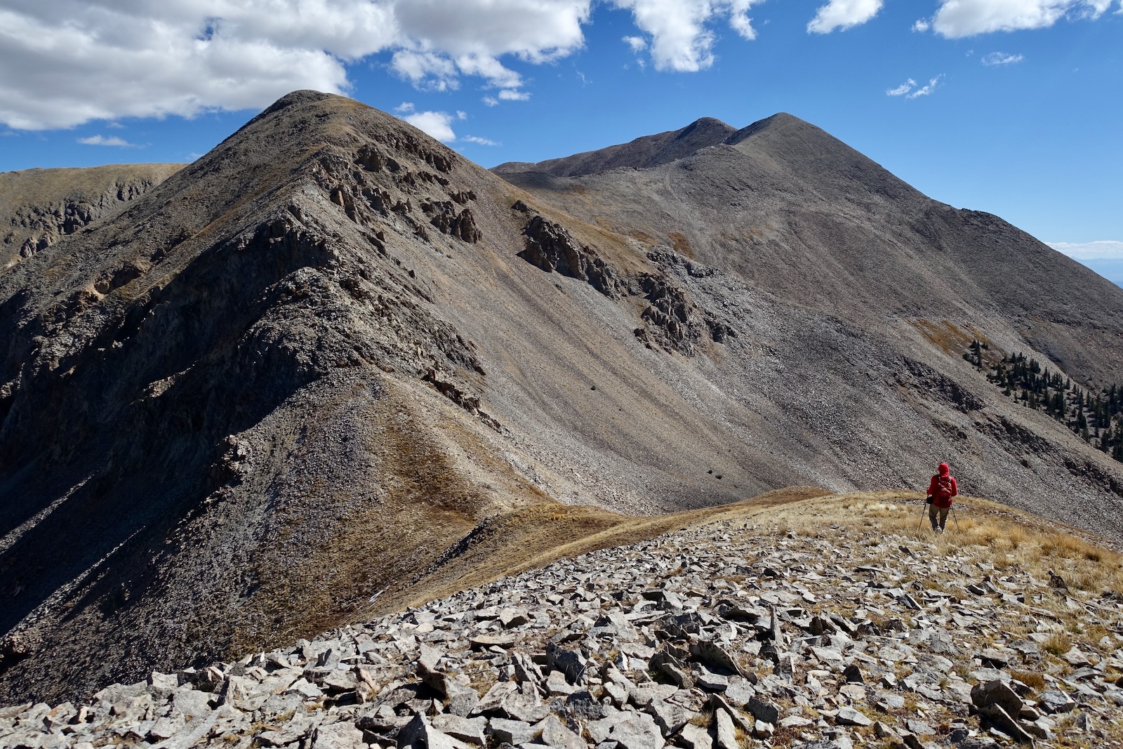
Gain the ridge at 2.7 miles, 11,960 feet with 500 feet of vertical remaining. The high-angle talus cone is in your face. You can't quite see the crest, but the climbing does round off onto the summit ridge beyond this image.

A subtle use trail tackles the first 100 feet. The grade is reasonable on the rock-tundra mix.

At 12,080 feet rock prevails over soil. The small caliber talus is stable. There is a braided and crude social trail initially but effectively you are on your own.

At 12,200 feet any semblance of trail is gone, the stones are bigger, and much of it is loose. The grade steepened on the rock pile but it never felt dangerous. Hikers with a moderate amount of experience on talus will have no trouble. Just be slow and methodical.
Like the Henry and Abajo mountains, the La Sals are a laccolith formed
when a large mass of magma solidified into stone below the earth’s
surface. The young range intruded above the surface 29 to 27 million years ago. Notice the crystalline nature of the igneous diorite rocks. They are considered intrusive because crystals had time to form and grow within the earth's crust.

When you reach great big beautiful slabs of stone, the pitch eases and the mountain rounds off.

Arrival onto the summit ridge is revelatory. The visual field is, a great vast aching vacancy of pure space.

The anticipation was intense as I walked toward the edge of the earth. My first visit to Moab was a pass-through in 1982. We stopped at Walker
Drug, the only grocery store in town, for supplies for a private float
down the San Juan River. Side streets were dirt, only the main drag was paved. Mount
Tukuhnikivatz made an indelible impression on me. Life takes its turns and 40 years later I was circling back to climb it. (THW, photo)

Crest the westernmost summit in the La Sal Mountains at 3.2 miles. At a leisurely pace with a couple of pauses, it took us 2.5 hours. Alas, the sky was hazy but we could make out Boulder Mountain west of Capitol Reef, the linear Book Cliffs north of Arches National Park, and the fourteeners in the San Miguel Mountains of Colorado. (THW, photo)
Then why climb Tukuhnikivats (sic)? Because I prefer to. Because no one else will if I don't--and somebody has to do it. Because
it is the most dramatic in form of the La Sals, the most conspicuous
and beautiful as seen from my terrace in the Arches. Because, finally, I
like the name. Tukuhnikivats--in the language of the Utes "where the
sun lingers."

In our experience the whopping 8,500 feet of relief to the Spanish Valley is rivaled only by Telescope Peak, 11,048', the roof of Death Valley, where the drop is 11,330 feet to Badwater (282 feet below sea level). Below, the West's greatest canyon-cutter, the Colorado River, splices the Moab Rim, cleaves Behind the Rocks, and meanders, entrenched and lost from sight on its journey to the sea.
As for the chromatic field, I like to think it is the sole possession of the American West. All around the peaks of the Sierra La Sal lies the desert, a sea of
burnt rock, arid tablelands, barren and desolate canyons. The canyon
country is revealed from this magnificent height as on a map and I can
imagine, if not read, the names on the land. To prove his point Abbey lists 121 place names, seen and (mostly) unseen, concluding with "Moab (cf. Kings II:iii, The Holy Bible)." (THW, photo)

The Middle La Sal Traverse is well described in trip reports. The massive counterclockwise circuit begins at the Gold Basin Trailhead and mounts "Little Tuk" (Point 12,048'), shown, Tukuhnikivatz, crosses the Razor Fang to Mount Peale, and cruises north over three substantial rollers to Mount Mellenthin. (THW, photo)

The North Block ripples off into the distance beyond Geyser Pass.

In June, 2016, we climbed five of six ranked peaks above 12,000 feet in the North Block. This image was shot from Mount Waas looking south to the Middle Block. (THW, photo)

The landscape splays out to the south crossing an immense span from neighboring South Mountain to Sleeping Ute Mountain, the Abajo Mountains, and Bears Ears.

Descending, maintain a friendly relationship with the rocks and you will glide down effortlessly.

Below, diorite blocks hold fast to the inclined mountain, gold ripples through purple-green stands of timber, and Medicine Lakes reflect the Utah-blue sky. (THW, photo)

Razor Fang Attempt
The vast majority of hikers should retrace their steps to the trailhead. "Razor Fang" is the informal name for a segment on the traverse to Mount Peale. It is rated the most difficult route in the La Sal Mountains because of the exposure on the thin ridge and shattered rock with unreliable holds. The traverse should be respected and reserved for experienced mountaineers. Do your research before attempting this crossing. There are many excellent trip reports on the internet. Below, my partner is descending into the Tuk-Peale saddle at 11,740 feet.
We made it up the first fang no problem. It was just a little spooky as we got accustomed to the exposure and friable rock.


This is the scene we encountered as we topped that first spike. On any other day we would have taken our chances but my son was getting married three days hence and we were risk adverse! We couldn't see the challenges ahead well enough, the rock was nervous, the exposure grave. Disappointed, we turned around. If you find yourself in a similar frame of mind, it is only 0.6 mile back to the junction where the Tuk Trail meets the east ridge.

We didn't want to give up on Peale so we returned to the saddle and made a reasonable drop southeast onto a green bench at 11,500 feet. From there, we attempted to cut east to the Mount Peale Trail. That proved both tedious and dangerous. Talus on the side hill passage was at the angle of repose and the mountain slid out from beneath us. We gave up and skittered and slid down into the trees. I mention this failed attempt as a cautionary tale. If you decide not to cross the Razor Fang, return to the Tuk Trail.

This image looks back up at the Razor Fang from our bailout bench. We engaged the Mount Peale Trail at 10,800 feet. We didn't have enough time to mount the rugged 2,000 feet to Peale. Thwarted this time, we intend to return to climb the high point of the range on the standard route next season.

No comments:
Post a Comment