Essence: The hike to Boskoff Peak has all the elements of a superlative adventure, featuring miles of dirt-smooth, well graduated trail; a stand of mature aspen; an explosion of diverse wildflowers; a break-out moment into the high alpine; an extended, fairly steep ridge climb overlooking adjacent fourteeners; a short crux with loose rock; and a sweet finish on a ridge just narrow enough to be exciting with thick slabs of stable stone. Boskoff Peak is the westernmost ranked summit on the ridge extending from Wilson Peak. Running parallel to the south is the ridge anchored by Gladstone Peak, extending west over Mount Wilson and El Diente Peak. Navajo Lake is nestled between the ridges. In 2019, Peak 13,123' and the ranked summit adjacent to the east, Peak 13,498', were named for two mountaineers from nearby Norwood, Christine Boskoff and Charlie Fowler. In 2006, the climbers lost their lives in an avalanche while attempting to climb the Genyen Massif in Sichuan Province, China. LiDAR increased the elevation of Boskoff to 13,134 feet with a rise of 456 feet. A short section of the lower trail near Woods Lake crosses land managed by Colorado Parks and Wildlife. The Boskoff-Fowler ridge marks the northern boundary of the Lizard Head Wilderness. The ridge is also the boundary between the Uncompahgre and San Juan national forests.
Travel: From the Mercantile in Sawpit, drive 1.1 miles west on CO 145
to mile marker 81.2. (This is three miles east of the intersection of CO
145 and CO 62.) Turn south on Fall Creek Road,
57P and measure distance from there. Cross the San Miguel River. Pavement ends
at 2.4 miles. At 3.6 miles, bear slightly right, staying on 57P, following the
sign to Woods Lake. Enter the Uncompahgre National Forest at 5.2 miles where 57P becomes FSR 618.
Cross Fall Creek on a narrow bridge at 6.3 miles. At 7.5 miles, the road to Beaver Park branches right. Stay on the road to Woods Lake. At 8.4 miles, turn into trailhead parking at the Woods Lake Recreation Area. Our odometer tends to underestimate mileage. A 2WD vehicle can make the trailhead.
Campground: The Woods Lake Campground has 41 private sites in an aspen grove. No reservations--first-come, first-serve. Water spigots were not functional in 2024.
Woods Lake State Wildlife Area: Recreation at Woods Lake requires a Colorado Parks and Wildlife permit.
Distance and Elevation Gain: 9.4 miles; 3,800 feet (Save 0.6 mile by taking the shortcut both ways.)
Total Time: 6:00 to 8:00
Difficulty: Trail, off-trail; navigation moderate; Class 2+ with mild exposure
Maps: Little Cone; Dolores Peak, Colorado 7.5' USGS Quads
Date Hiked: July 6, 2024
Quote: Montani semper liberi— Mountaineers are always free. Galen Rowell, National Geographic, April, 1989.
Total Time: 6:00 to 8:00
Difficulty: Trail, off-trail; navigation moderate; Class 2+ with mild exposure
Maps: Little Cone; Dolores Peak, Colorado 7.5' USGS Quads
Date Hiked: July 6, 2024
Quote: Montani semper liberi— Mountaineers are always free. Galen Rowell, National Geographic, April, 1989.
This truly joyful segment of ridgeline is a rousing tribute to Christine Boskoff. (Thomas Holt Ward, photo)

Route: Hike south on the Woods Lake Trail to the junction with the Elk Creek Trail. This description stays on the Woods Lake Trail until it intersects the southwest ridge of Boskoff Peak. Alternatively, from the junction, ascend south to the ridge. Climb northeast on the ridgeline to the summit.

Route: Hike south on the Woods Lake Trail to the junction with the Elk Creek Trail. This description stays on the Woods Lake Trail until it intersects the southwest ridge of Boskoff Peak. Alternatively, from the junction, ascend south to the ridge. Climb northeast on the ridgeline to the summit.
Fowler and Boskoff peaks are visible from the Woods Lake Campground. On the morning of our hike we simply walked from our campsite to the trailhead.

Locate the trailhead, elevation 9,380 feet, on the east side of FSR 618. Woods Lake Trail No. 406 bears south, crosses into the Lizard Head Wilderness, passes the Elk Creek Trail above timberline, crosses from the Uncompahgre into the San Juan National Forest on the southwest ridge of Boskoff, and ends in Navajo Basin at the Navajo Lake Trail. The trail is open to equestrians and hikers only.

The pounded trail passes Woods Lake at 0.2 mile. Early in the morning, the San Miguel Mountains were reflected in molten ripples.

At the four-way intersection at 0.3 mile, stay straight. The sign is optimistic--the Elk Creek Trail junction is actually almost 3.0 miles afar. In the afternoon the previous day, we looped around the lake on the Lone Cone Trail. We were greeted in no uncertain terms by an irritated bear growling nearby.

We saw evidence of beetles ravaging old growth Douglas fir, sadly. However the aspen are thriving. This vast stand hosted trees as old as aspen get, about 150 years.

There was so much to look at as we trundled up the lush, forested trail. Blue flax, Coulter's erigeron, monkshood, and cow parsnip were all having a banner year. Woods' rose wafted a mind altering fragrance. (THW, photo)

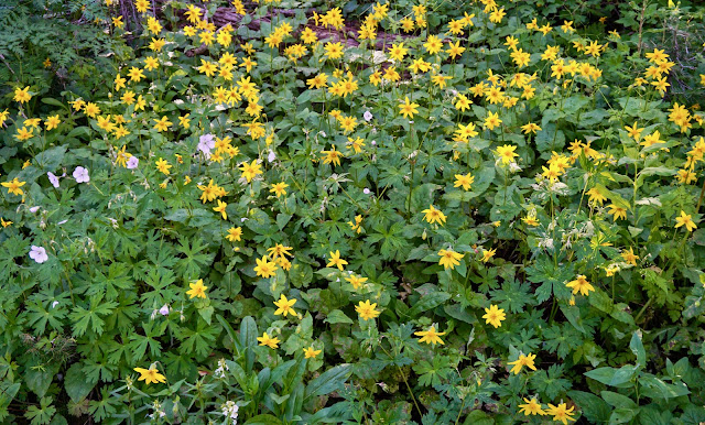
Everything about this maintained trail is wonderful--the consistent grade and forest duff surface, profound silence, and fresh saw cuts
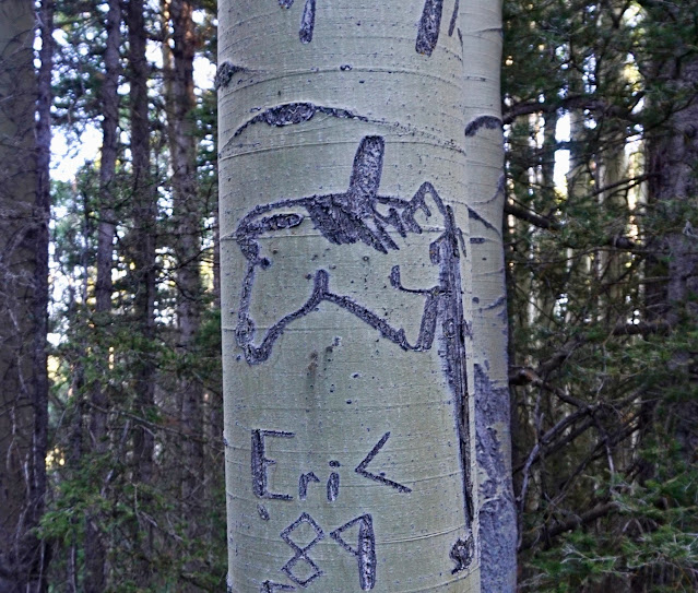
of cleared deadfall. At 0.7 mile, a stream ran through a culvert under the trail. All the creeks were flush. We jumped and hopped across rivulets. Water dripped and oozed. There was a sign tacked to a tree at the boundary of the Lizard Head Wilderness. Overgrown tree blazes suggested the trail was built long ago. This horse arborglyph was one of the more recent cowboy glyphs. (THW, photo)
At 1.2 miles, Little Cone stood tall enough to clear the corn husk lilies.

Flower-filled, serene glades functioned as visual corridors.

Two exquisite cascades join beside the trail at 2.7 miles, 11,080 feet. One of them originates from the spring near the Elk Creek Trail junction. Mountain bluebells crowded the waterways. (THW, photo)

Just up the trail an historic log cabin had fallen into ruin.

Emerge from the timber into the high alpine at 11,420 feet. Tundra euphoria was instantaneous. The sky instantly transitioned from zero horizon to infinity. Magenta and Wyoming paintbrush, alpine avens, sky pilot, and veronica broadcast tiny spots of color. We could see the Elk Creek Trail running along the lower west face of Boskoff.
(THW, photo)

A perennial spring gushed out of the mountainside.

At 3.3 miles, 11,520 feet, reach the junction with the Elk Creek Trail. It bears east making for Silver Pick Basin. To the west is an excellent view of colorful Dolores and Middle peaks. This isolated cluster in the San Miguel Mountains includes a third ranked summit, Dunn Peak. It is possible to climb all three in one day but the effort is arduous and the ridge has sustained exposure. (THW, photo)

On the way up Boskoff, we decided to stay on the Woods Lake Trail until it contacted the southwest ridge. It seemed more elegant and we thought hikers climbing Boskoff from Navajo Lake might have created a social trail. Our return route would be a pleasant ascent route. It leaves from the junction and makes for the ridge, saving 0.6 mile. On our way down the shortcut, we walked by the little patch of snow, image-right.

For those continuing on the Woods Lake Trail, it holds the contour all the way to the southwest ridge. We contacted the shoulder of the mountain at 3.9 miles. Out of curiosity, we stayed on the trail until we could see into Navajo Lake Basin and El Diente Peak. Failing to find a social trail up Boskoff, one mile shy of the lake we cut up to the ridge. You need to pass the small prominence seen below on its north side.

This image looks up at the access ridge from the top of the prominence. Clearly, we were going to get a free lift up the tundra slope for another 500 feet at least. The ground was spotted with aromatic phlox, wall flower, clover, and smelowskia.

The ridge steepened but footing was good on a shale surface with igneous floaters. Old man of the mountain decorated the slope.

There is one short stretch at 12,360 feet that was challenging. Some skilled climbers will breeze right through without giving it much thought.

There is no best way to propel through this obstacle. We went up the center and got into some sketchy Class 3 on loose, untrustworthy rock covered with debris. On our return, we stayed more toward up-mountain-left. We plunge-stepped down an escalator slide. Fun and fast. (THW, photo)

Going up, we favored larger chunks of stone.

This image looks down-mountain from the top of the crux at 12,600 feet. (THW, photo)

Looking up-mountain from the same place, it's a totally different scene. A distinct use trail climbs through a red band of scree and chipped rock. (THW, photo)

At 12,760 feet, the composition of the rock transitioned to igneous granitic blocks. Climb the gray outcrop watching out for unseated holds.

The outcrop is a rounded nose at the lower end of a sublime ridge experience that extends to the summit. (THW, photo)
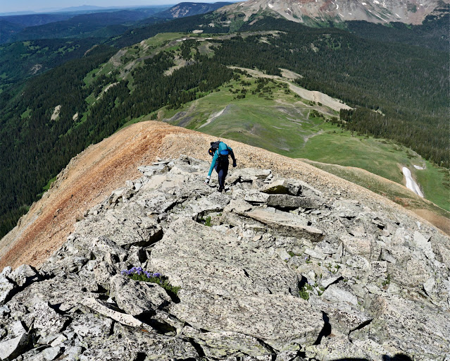
The slabs and blocks of stone are so stable, the ridgetop is effectively a joy-inducing sidewalk.

The spine averages eight feet in width. It's not at all scary. Rather, it is one of the finest summit ridges in Colorado. The last 200 feet are a total blast.

Sky pilot tucked into stone speaks to the union of opposites so perfectly and frequently paired on our planet.
(THW, photo)

The view borders on the incomprehensible. On the opposing ridge is El Diente Peak, 14,175' (LiDAR).
The view borders on the incomprehensible. On the opposing ridge is El Diente Peak, 14,175' (LiDAR).

I hiked into Navajo Lake along the West Dolores River in 2007. I was tempted by Boskoff's symmetrical shape and vowed to return some day to climb it. Below, I am on the final arc to the summit, dream fulfilled. (THW, photo)

We alighted on the small, rocky, cone-shaped crest at 5.0 miles. Judging from the peak register, this mountain has a lot of visitors. Every
mountain on Earth is an individual. Inevitably, there is a feeling of completion and satisfaction upon reaching the summit after puzzling out the navigation, experiencing the structure of the mountain, the various rock formations, its climbing challenges, its unique view of the surrounding mountain-scape, and its flora and fauna.

Fowler Peak looks plausible from Boskoff on the topo but trip reports caution against making the traverse. Wilson Peak, 14,021' (LiDAR) is the pivot point at the head of the basin.

Looking northeast we could see the Telluride Airport and the impressive collection of high peaks in the Mount Sneffles Wilderness and Uncompahgre National Forest.

To the south are the east and west blocks of the Rico Mountains with the La Plata Mountains visible through the gap.

We were high enough to just make out the summit of Dunn Peak, Lone Cone, and Flat Top Peak, image-right. Further west and north are the La Sal Mountains in the Utah world.

Woods Lake is tucked up against the base of the mountain.

The slab descent is pure pleasure.

After doing the slip and slide through the crux, at 12,040 feet, we cut down off the ridge to the north. A small patch of snow remained and all around its edges snow buttercups bloomed having emerged from winter just minutes earlier. We rejoined our upcoming track right at the Elk Creek Trail junction.
Fowler and Boskoff peaks are visible from the Woods Lake shoreline. It was a privilege and pleasure to climb one of the two peaks memorializing the renown local climbers.

2 comments:
Love WLCG and have looked up to Boskoff from camp the last four fall seasons. I want to attempt the summit and your presentation here will greatly help me visualize the route. Thank you for posting it. - Jeff G., Santa Fe, NM
Jeff, There is so much joy to be had by climbing a mountain you've been looking at for years. This mountain most especially. It puts another piece in your personal landscape puzzle. Thanks for reading Earthline. Debra
Post a Comment