Essence: The Rico Mountains are a small range separated into two blocks by the
Dolores River. Dolores Mountain is on the east block, due west of Blackhawk Mountain,
the high point in the range. Dolores is a favorite destination for Rico residents who can see the peak from town and hike directly from home. This description begins southeast of the mountain in Hotel Draw and utilizes the Colorado Trail for 4.2 miles each way. The long walk through flower-enhanced woods rises into a pristine high basin and leaves the cross-state trail at "Blackhawk Pass." It is a lot of miles for a "twelver." The paybacks are tundra expanses, an exceptional summit ridge clean of everything but stone, and the view of Rico 3,300 feet directly below. The hike isn't especially difficult but it's not trivial either. Give up 500 feet that you must recover. One especially steep slope will challenge the most fit. Dolores pairs easily with Blackhawk Mountain. Experienced scramblers comfortable with exposure can add Whitecap Mountain. LiDAR has increased the elevation of Dolores Mountain to 12,117 feet with a rise of 424 feet. The hike is on public land within the San Juan National Forest.
Travel: In a 4WD, high clearance vehicle turn west from US 550 into Purgatory
Resort and measure mileage from there. Drive up the winding road and
turn right on FSR 576 near the upper
parking lots at a small brown building (0.4 mile). Turn right at 3.2
miles toward the Hermosa Creek Trail. At 8.7
miles the spur to popular mountain bike trails branches left. Stay on the main road following a sign for
Hotel Draw and Bolam Pass. The road deteriorates. Ford
Hermosa Creek at a
shallow, distributed, and flat crossing at 10.2 miles. Avoid in high
water. At 11.2 miles turn left on FSR 550 (unsigned) toward Hotel Draw. The dirt
road narrows and is prone to developing deep ruts. There is a small pullout on the right and a sign for the
Colorado Trail at 15.0 miles, Benchmark 10,419'. Allow 45 minutes to one
hour from Purgatory.
Distance and Elevation Gain: 12.0 miles; 3,350 feet. Blackhawk Mountain adds 0.2 mile, 350 feet.
Total Time: 6:00 to 7:30
Difficulty: Trail, off-trail; navigation moderate; Class 2+ with no exposure
Maps: Hermosa Peak; Rico, Colorado 7.5' USGS Quads
Date Hiked: July 2, 2024
Quote: Sweet hike. Loved: the green wall from hell, dancing across rock-and-roll rocky ridges, riding the rhythm of an old rent horse back to the trailhead barn, sitting in the porch swing at home, swigging a pint of ale, watching the sun give way to the stars, feeling the exhilaration of exhaustion, falling into and becoming the night without a thought of the future, holding on to the feeling that comes from a visit to the places where the gods dwell. Gene Taylor reflecting on Dolores Mountain.
Dolores Mountain is relatively small in stature but visible nevertheless from far-flung peaks with its distinctive elongated white summit ridge and isolated position. The hike is long but the rewards are continuous and the journey is deeply satisfying.

Route: From the trailhead in Hotel Draw, walk northwest on the Colorado Trail to Blackhawk Pass. Ascend west toward Blackhawk Mountain for 200 feet. Leave the trail and head southwest on a thin path to the southeast ridge of Blackhawk. Walk west on a barely visible game trail to the southwest ridge of Blackhawk. Descend west, giving up 500 feet to the saddle. Finish on the east ridge of Dolores Mountain. Return as you came or climb the southwest ridge of Blackhawk to the summit before returning to Blackhawk Pass.

From the trailhead, elevation 10,400 feet, bear north on the Colorado Trail (CT),
open to hikers, equestrians, and bicyclists. Hotel Draw is a
resupply location for thru-hikers. Plus, there are popular mountain bike
loops on both sides of the divide passing through this point. The softly rounded, north-south running ridge drops away to Hermosa
Creek on the east and Scotch Creek on the west. Ascend gently through
a mixed Douglas-fir, spruce and aspen forest. The vista opens eastward at 0.4 mile overlooking Graysill Mountain and Grayrock Peak.

Look north to Point 11,924' on the south ridge of Blackhawk East.

Pass over Point 10,721' and then enjoy a slight downhill. If you take a close look at the Hermosa Peak quad you'll see that the trail once took a decidedly more direct route into the Straight Creek Basin. It flanked Point 11,924' and hovered high on the east wall of the basin to Blackhawk Pass. The Colorado Trail post seen below is planted at the old diversion point. On our verdant hike, the trail was saturated, spruce were sprouting new growth, and youthful trees were sheltered by their old-growth elders.

The CT hangs onto the 10,700-foot contour while traversing a sunny glade. I've been on this stretch of trail many times and always look forward to this opening in the timber.

Cross two rivulets and enter the Straight Creek draw.
Shortly before the crossing at 2.5 miles, 11,020 feet, pass through a spectacular garden where wildflowers are head-tall and bountiful: corn husk lily,
delphinium, osha, bluebell, and cow parsnip. Altogether, I listed 45 species blooming on this hike. Straight Creek is an important water source and gathering place for game, backpackers, and bikepackers.

Pass through tree limit and enter the alpine where a great wash of crystalline light illuminates the tundra and columns of stone bracing the basin. Cross Straight Creek once again at 3.5 miles, 11,460 feet.

Blackhawk Mountain is in line of sight as the trail tracks east of unnumbered Point
12,300'.

The trail makes a sweeping turn to the right at 4.0 miles and ascends to Blackhawk Pass, image-right.

Arrive on Blackhawk Pass at 4.2 miles, 11,980 feet. A startling and expansive visual sweep may be what we've come to expect arriving on a pass in Colorado, but still, it takes a moment to process. Featured in this image is nearby Section Point (image-center), symmetrical Hermosa Peak, and a riot of massive stone monuments featuring Grizzly and San Miguel peaks.

Leave the Colorado Trail on the pass and bear west toward Blackhawk Mountain.

There isn't an established trail on the east ridge of Blackhawk as the sign might imply but a footpath comes and goes all the way to the peak.

Colorado tansy aster is an uncommon plant but the last few times I've been on the pass there have been nice patches. Other alpine favorites included snow
buttercups, alp lily, snowball saxifrage, American bistort, kittentail, moss
campion, and alpine phlox. (Betsey Butler, photo)

For Dolores Mountain, at 4.4 miles, 12,200 feet, leave the east ridge and hike southwest on a thin footpath cutting across the slope. The boot-wide thread gains about 100 feet as it crosses two debris channels, the upper end of Straight Creek.

Arrive on the southeast ridge of Blackhawk at 4.6 miles, 12,300 feet, the highpoint of the trek to Dolores Mountain. Whether I am here during summer green or autumn gold, the colors in the Aspen Creek basin are pure and sparkling. The spruce are the color of night and self-luminous Whitecap reflects the heavens.

Cut west on a subtle game trail while losing a little elevation. Intersect the southwest ridge of Blackhawk at 4.8 miles, 12,220 feet.

Cut west on a subtle game trail while losing a little elevation. Intersect the southwest ridge of Blackhawk at 4.8 miles, 12,220 feet.
Almost five miles into the hike, Dolores Mountain, the lowest peak on the east
block of the Rico Mountains, comes into view. From here, the route loses over 500 feet to the 11,700-foot saddle and then climbs 424 feet to the summit.

Descend on a game trail to a chocolate-colored tarn.

Cross an exhilarating tundra-topped terrace.

Plunge due west down an ultra steep slope to the saddle at 5.3 miles.

Ascend the pleasant east ridge of Dolores.
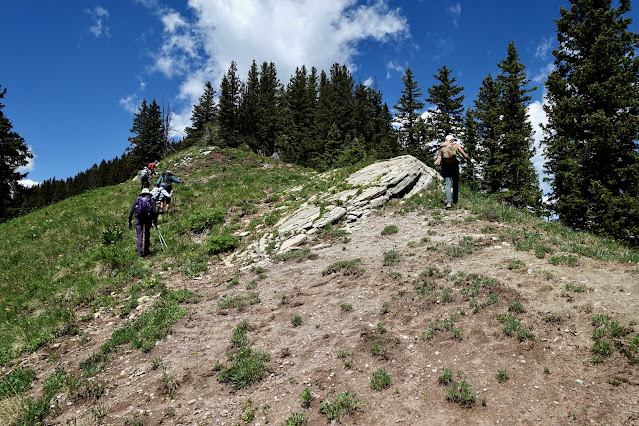
These hikers are mounting the east ridge with the plunge wall behind them. (Thomas Holt Ward, photo)

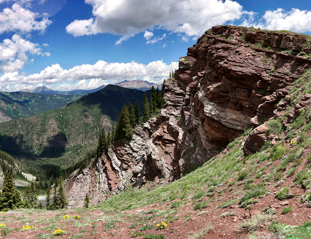
The ridge moderates on an interim rise at the contact between red and white bands of stone. The surrounding mountains are composed of Cutler Formation, over 1,000 vertical feet of sandstone, siltstone, and conglomerate beds. The bands of gray columnar cliffs seen throughout the area and the summit ridge of Dolores are sills--intrusions of igneous rock between preexisting layers of Cutler. Old man of the mountain was blossoming profusely in the red zone. (Betsey Butler, photo)

Our group bypassed a gendarme, the only obstacle on the hike, on the south side, playing it out at different levels, all great fun. So deep into the hike, we were happy to finally be on solid rock.

The ridge is steep initially. (THW, photo)

The scramble is Class 2+ with good holds on stable rock. (THW, photo)

The climb moderates and the summit ridge bumps along. Scamper across plates of gray talus and arrive on the rounded crest at 5.9 miles. The peak register was loaded with the names of Rico residents who presumably climbed from the west--direct and steep.

We had been promised a Rico sighting and so we walked 0.1 mile further to the west end of the ridge.

And there was Rico 3,300 feet below. If you live in town it'd be easy to pick out your home. We had climbed many of the peaks on the west block and there they all were. First, we did a northern set combining Elliott Mountain, Sockrider Peak, and Johnny Bull Mountain. We returned and climbed Calico Peak, Eagle Peak, and Anchor Mountain. Elliott Mountain with a LiDAR reading of 12,348 feet is the highest peak on the west side. (THW, photo)

I find it intriguing that there are two mountains named Dolores in close proximity. Image left is the threesome of Dunn, Middle, and Dolores peaks. Moving to the right is Little Cone, the Wilson group of 14ers, and Lizard Head.

There is something just so appealing about Dolores Mountain. I love that you can roam all over the expansive summit. This is in sharp contrast with the summit cones of both Blackhawk (left) and Whitecap mountains. (THW, photo)

Below, returning hikers are off the igneous layer and are ascending back to the interim rise at 12,020 feet. (THW, photo)

Save some energy for the concentrated elevation gain on the inclined pitch. (THW, photo)

Blackhawk Mountain (optional)
If you have not been on the highpoint of the Ricos, this is an excellent opportunity. From the southwest ridge the summit of Blackhawk Mountain is a mere 0.3 mile and 450 vertical feet. This image looks down on hikers coming up the ridge. Judging from the peak register on Whitecap, shown below, strong climbers do all three peaks in one long day. As I said previously, Whitecap is decidedly more challenging with fractured, loose rock on exposed walls. Check out the Earthline post to see if it's for you. (THW, photo)

This image was shot from the Blackhawk summit looking way down on the pass. There are a couple of people clusters visible. Blackhawk East is a strong favorite. If it interests you, please see the Earthline post for the safest route through the Cutler bands and igneous sills. (THW, photo)

Below, hikers can be seen returning to the pass on the ridgeline.

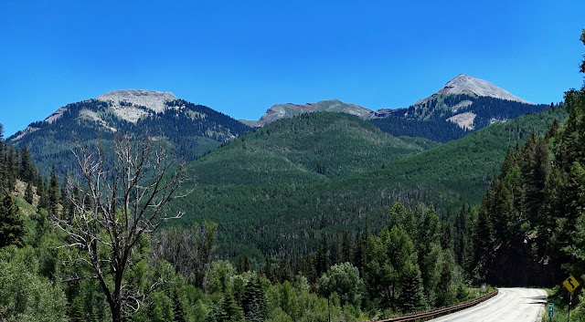
Heading north on CO 145 between the towns of Dolores and Telluride I have passed this scene countless times a few miles south of Rico at mile marker 43. Visible from the highway are Dolores, Blackhawk, and Whitecap mountains. Dolores Mountain had been on my peak wish list for years and it feels wonderfully satisfying to have put another piece into the landscape puzzle in Southwest Colorado.
No comments:
Post a Comment