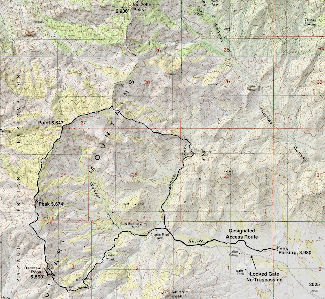
Essence: This loop takes in Osobavi Peak, a ranked summit, and a numbered point on the principal divide in the Baboquivari Mountains. We intentionally did the circuit clockwise so we'd be walking toward Baboquivari Peak, the most revered monument in the lower quadrant of Arizona. For the Tohono O'odham people, the peak is at the heart of their origin story. Many of us take our bearings from the monolith. The crest of the north-south running ridge marks the eastern boundary of the Tohono O'odham Nation. We were surprised to find a highly useful pounded trail, possibly a migrant corridor, running the length of the ridge. The diversity of landscapes in Arizona is unsurpassed in the western United States. I favor the rolling desert grasslands at the bottom of the state--the lure of expansive tracks of empty country unfettered by human activity. Untroubled silence and the sanctuary of solitude are absolute on this circuit. The hike is primarily on Arizona State Trust Land. The first mile is a designated access route through a public easement.
Travel: There is a Chevron station on the Ajo Hwy, AZ 86, at Three Points, Robles Junction. Drive
south toward Sasabe (Port of Entry) on AZ 286 through the Buenos Aires National Wildlife Refuge. It
is about 30 miles to mile marker 15.8, just past a big pullout on the
west side of the highway. Turn west on an unsigned road and measure distance
from there. Cross a cattle guard. There is plenty of dispersed camping. The graded road has some washboard. At 2.6 miles
go left at the split following a hand painted sign for the Mormon Corral. At 3.1 miles turn right when the road to Mormon Corral goes left. At 5.5 miles turn right following the sign for the Designated Access Route around private property. (If you were to continue, in a quarter mile you'd come to a locked gate posted, "Dead End, Private Property, No Trespassing.") Park in front of boulders on your left in a wash at 5.6 miles. Display an Arizona State Trust Land permit. The trailhead is 2WD accessible.
Distance and Elevation Gain: 10.5 miles; 2,800 feet
Total Time: 6:00 to 8:30
Difficulty: Trail, off-trail; navigation moderate; Class 2 with no exposure; Hike on a cool day and carry all the water you will need.
Map: Mildred Peak, AZ 7.5' USGS Quad
Date Hiked: February 18, 2025
Total Time: 6:00 to 8:30
Difficulty: Trail, off-trail; navigation moderate; Class 2 with no exposure; Hike on a cool day and carry all the water you will need.
Map: Mildred Peak, AZ 7.5' USGS Quad
Date Hiked: February 18, 2025
Personal Note: Our goal was La Jolla Peak located directly south of Baboquivari Peak. Having recently climbed Peak 6,883', we did not want to repeat the nasty drive into Thomas Canyon where the standard route begins. Our intention was to traverse the ridge from Osobavi Peak to La Jolla, walking toward Baboquivari. We had the energy for it, but not the time. This is a hike to be savored, not rushed. We plan to return.
Quote: Aridity rules the air, weathering rules the rock, the shadows are as deep as time. This land was born at the center of old. Ellen Meloy
Quote: Aridity rules the air, weathering rules the rock, the shadows are as deep as time. This land was born at the center of old. Ellen Meloy
Looking north from Osobavi Peak, the only ranked summit on this circuit is Peak 5,674', image-left. La Jolla Peak visually melds into Baboquivari Peak. (Thomas Holt Ward, photo)
Route: From parking, walk west on the designated access route for one mile. Transition onto a 4WD track on State Trust Land. Remain on the rough road bearing west and southwest to Chutum Vaya Pass. Turn north and climb the south ridge of Osobavi Peak, off-trail. Hike north on the informal ridge trail, pausing to climb Peak 5,674' and Point 5,647'. Continue on the divide for another 0.6 mile. Descend on an east-bearing ridge into Jupiter Canyon. Follow a mining road south and close the loop near the Charlie Bent Well. Retrace your steps on the designated access route.
Awakening light saturates the Baboquivari Mountains as they stream south from the free-standing landmark. Mildred Peak is isolated out in front of the divide, image-left.

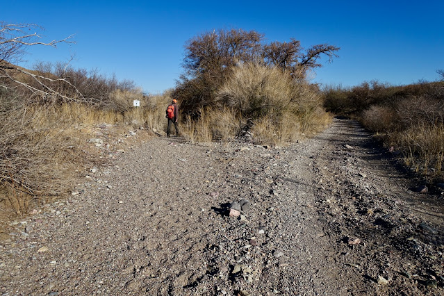
This is the sign posted on the access road at 5.5 miles.

The designated access route is sponsored by Arizona Game and Fish. From parking, elevation 3,980 feet, bear west in Shaffer Wash. The spongy, gravelly arroyo is framed by a mesquite bosque. 
At 0.3 mile turn out of the wash and onto a singletrack, paralleling the watercourse on its north. The goal is to get back to the incoming road that goes through private property. The workaround isn't bad if you nail it. Follow signs carefully. There is a maze of stock trails and we lost our way almost immediately. Ambushed by catclaw and mesquite, we chewed up too many miserable minutes. We did a better job in the return and the map reflects the proper route.

The designated access route cuts around the perimeter of corrals on the north. They are constructed with pipes and juniper logs, very similar to the corrals in nearby Thomas Canyon. In this image the moon is setting over Mildred Peak which looks rather like a small version of Baboquivari. Osobavi Peak is on the horizon to its right.

At 0.45 mile climb over a gate posted, "Private Property, Foot Access Permitted."

The designated access route returns to Shaffer Wash and merges onto the road at 1.0 mile. This route remains on the primitive road for the next two miles to Chutum Vaya Pass. There were both horse hoofprints and tire tracks on the road but we saw no one. At 1.5 miles, the road emerging from Jupiter Canyon, our return route, comes in on the right. Baboquivari Peak, the sentinel that can't be confused with any other on Earth, rises above all else.

The Charlie Bent Well is an operational concern. The windmill was twirling smoothly pumping water into several tanks. Pass through an open gate.

The road turns to the southwest and starts climbing into the foothills flowing from the backbone of the Baboquivari Mountains. One of the things I find so fascinating about this landscape is the overall uniformity, occasionally interrupted by alluring solid blocks of stone that have stood the test of time and erosion. (THW, photo)

A south fork of Shaffer Wash drains waters gathered from the divide. The road crosses the (dry) streamway at Indian Tank, 2.4 miles. The track was washed out at the crossing but materialized once again on the other side of the creek. This is contrary to what is depicted on the topo. It implies the road stops at Indian Tank. The road pitches, flattens for a time in a broad valley, shown, and then resumes climbing. It was tempting to shortcut off-road to the ridge. But the road actually affords efficient access to Chutum Vaya Pass. The pass is just left of the first roller south of Osobavi Peak.

A thin Arizona oak woodland materializes. At 2.9 miles, 4,860 feet, the road splits. Crank to the right and climb steeply on a slick surface. (THW, photo)

As we drew closer to Osobavi Peak its colorful, multi-stone beauty was enticing. From there we analyzed the climb up the south ridge. Since we wanted to continue north we were curious how we'd get around the east side. Turns out the aforementioned ridge trail goes through the appealing notch. (THW, photo)

Shortly before the pass the road summarily ends and morphs into a trail. Arrive on Chutum Vaya Pass at 3.2 miles, 5,180 feet. The essence of this pivotal place is heart stopping. Golden rolling hills flow south into Mexico, bodacious Baboquivari Peak lords over its smaller stone brethren, multiple dikes crisscross the landscape for miles, and the Tohono O'odham Nation spreads out to the west. On the Mildred Peak quad, the land is ascribed to the Papago Indian Reservation. However, "Papago" has fallen out of use and the indigenous people call themselves Tohono Oʼodham, meaning "desert people."
The Desert Mountaineer is a hero of mine so I checked out his website to see whether he'd written about this area. Indeed! He has a wondrous post titled Babo to Border in which he describes his 38 mile trek through the range from Baboquivari Peak to the international border with Mexico. He credits climber Andy Martin with the Tohono O'odham translation for the pass. Chutum means "bear" and vaya means "well." Bear Canyon runs west from the pass. The Charlo Juan Well is at 3,800 feet within the canyon. (THW, photo)

A distinct trail comes up to the pass from the south and keeps right on going north. The Desert Mountaineer posted Babo to Border in August, 2024. He wrote, "This is a pretty lawless area. Undocumented border-crossers regularly try to sneak into the States here. The Mexican drug cartels are very active in these parts." In 2023, Sasabe, the Port of Entry, just 16 miles south of our turnoff from AZ 286, was a flash point in a battle for the human and drug smuggling corridor. We did not see any recent footprints on the trail but we did see trash scattered all over the hillsides and alongside the trail. Of note, we did see cougar scat in several places. It would be wise to hike with one or more friends.
Duck under the maintained barbed wire fence. We crawled under it repeatedly for the next 3.5 miles while walking on the ridge. It is conceiveable that the trail is hammered by stock moving along the fenceline, though we saw no evidence to support that theory. (THW, photo)

Thank you, Ellen Meloy for, "This land was born at the center of old." Osobavi is a colorful mix of sedimentary and volcanic formations dating to the Mesozoic Era, 252 to 66 million years ago. Baboquivari Peak is composed of Baboquivari Granite, a much younger rock from the Tertiary Era, 66 to 2 million years ago. The dikes running on the surface throughout the range are also Tertiary in age, possibly made of Baboquivari Granite. It wouldn't surprise me to learn that Osobavi, Mildred, and other bare-stone peaks are overlain by granite.

As you approach the peak, the migrant trail skirts the summit on the east. It is best to leave the trail at the fenceline and start your climb from there. My partner claims he saw slight evidence of a social trail but I did not decipher one. The climb gains 290 feet over 0.2 mile.

Stay on the ridgeline as best you can. The surface is rubbly but there are no obstacles of note. Unless dodging shindaggers counts.

Looking back, see the divide curving first this way and then that, rising and falling over and again. I am in love with this landscape. Its simplicity and isolation feels like coming home to the truly wild. (THW, photo)

Alight on the summit of Osobavi Peak at 3.7 miles. With a rise of 290 feet, the mountain misses qualifying as a ranked summit by just ten feet. If the peak register is an accurate account, years go by without visitors. The container, deeply buried in the summit cairn, was placed by the Southern Arizona Hiking Club in 2001. The mountain is on their list of peaks. For those turning back from this summit, my GPS recorded 1,700 feet of vertical to this point.

Point 5,130', close by in the west, is on the Tohono O'odham Nation. Permits are required to step onto their land.
(THW, photo)

Looking over the abrupt edge it was clear we had to descend on the south ridge. As is often the case, there was no GPX track or trip reports on this hike so we were figuring it out on the fly. Look carefully at this image and you will make out the strip of trail near the ridgeline.

Back on the trail we were delighted to see it stayed high and went right through the notch. (THW, photo)

Osobavi's hatchet-edged north face may have inspired the name, "scythe bedrock." (THW, photo)

There are some rather significant undulations on the divide. Being ridge purists, we occasionally left the trail and stayed right on the ridgetop. We scared up three pronghorns. We saw another group of four later in the hike. We went up a moderately steep roller topping out at 5,580 feet, 4.6 miles. We made a 90 degree turn with the fenceline. As we closed in on Peak 5,674' the dike preceding it was the same composition as the dike running over the top of Peak 6,883'.

We climbed the dike just for fun. The south side of the peak was technical so we got back on the trail flanking the east side of the block.


We gained the summit of Peak 5,674' at 5.0 miles. Of course, we thought it was just another bump on the divide. But when we got home and checked it out on Lists of John, we were informed that not only did the prominence have a rise of 454 feet, it was the only ranked summit on our hike. The peak register had been through a fire and was in ashes.
(THW, photo)

Next up was Point 5,647', north of another dike.
The trail is quite remarkable, a true mystery. Surely, the origin of this pathway hearkens back to centuries of indigenous use. There are places where the terrain was carefully analyzed, much as engineers would do laying trail today. Trash and discarded water bottles would imply the trail is active with migrants in the present day.

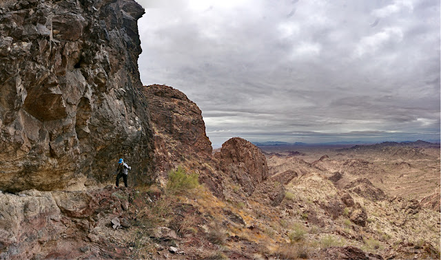
The path leaves the ridge crest and diverts to the west side of the next prominence at 5.5 miles. There are several tough Class 2+ moves and friction pitches that chewed up the clock. We assumed there was a cliff on the north side of the roller but looking back we didn't see any major obstacles.

As we approached Point 5,647', the ridge narrowed and sported an impressive cliff on the east. The trail punches right through the dike, shown. I love this hike for the many nuances, little challenges, and big pleasures.

The climb to Point 5,647' is short and steep.

We rounded Point 5,647' at 6.0 miles. Read the Desert Mountaineer's description of Peak 5,380' to the northwest on the Tohono O'odham Reservation. The Class 5 climb was one of his most memorable which says a lot because he's mounted 400 summits on the reservation.

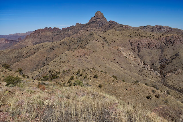
At 6.7 miles, south of Point 5,630', we decide to bail off on an east ridge that drops into Jupiter Canyon. We will come back for La Jolla Peak. It was a tough decision but a good call because it took 2.5 hours to walk back to our vehicle. There were just too many uncertainties. This image was shot from our diversion point from the ridge. When we return we have some zigzagging and climbing to do to reach La Jolla. In this image it is centered under the south face of Baboquivari--not to be confused with Peak 6,883', the monolith's immediate neighbor to the northeast.

Our descent on the east ridge was once again aided by a stock, game, or human trail.

Descending, there's an improved view of the knobby ridge leading to La Jolla on the left. The highpoint remains hidden from view. (THW, photo)

At 4,820 feet the ridge takes a dive. Even with switchbacks it is steep, slick and loose. We arrived on the floor of Jupiter Canyon at 7.8 miles, 4,420 feet. We struggled awkwardly to bypass two catchment walls on the east but a short time later saw a road on the west side of the dams. It goes across the gorge and becomes the main track through Jupiter. Both the wash and road go through a breach in a most beautiful dike. The map reflects the easier route using the road.

The road served the Jupiter Mine which functioned in the canyon from 1930 to 1941. Gold and silver were the primary commodities. Reportedly, there were shafts and several thousand feet of underground tunnels. Earthline cautions against exploring abandoned mine workings.

The road through Jupiter Canyon takes aim at Mildred Peak. (THW, photo)

We closed the big loop at the junction of Jupiter and Shaffer roads at 9.0 miles. The designated access route starts up at 9.5 miles, clearly marked. Jog to the left to be in compliance. If you continue straight, you will come to a faded private property, no trespassing sign and will have to backtrack. We did a better job of staying on route on our second try in the afternoon. Remember, after the trail ends there's still a quarter mile remaining in Shaffer Wash to return to parking.