Essence: Canaan Mountain is south of Zion National Park and north of the Arizona state line. It is an 8-by-10-mile block of Navajo
Sandstone, 2,000 feet high, ringed by Vermilion Cliffs. This post describes our initial tour of the Canaan Mountain world. We did the standard Squirrel Canyon to Water Canyon loop which took us by the White Domes. We tacked on a 3-mile attempt on The Beehive and a 3-mile venture to Water Peak and the Eye of Heaven arch. This was an insanely outrageous 17-mile hike. While we saw many mind-numbing features, there is so much left to explore. We'd like to make another run at the The Beehive and top the highpoint of the mountain at 7,363 feet. Note that about 12 of the 17 miles were in deep sand. I can't overstate the effort expended walking in soft sand. Most importantly, trails should be considered routes. They are unsigned and cairns are infrequent when crossing great swaths of sandstone. Plus, there are superfluous old roads and trails braided all over the mountain. It would be all too easy to get very disoriented on this massive plateau. You must carry a topographical map and a GPX track from a trusted source and be intimately familiar with using both. The hike is within the 44,500-acre Canaan Mountain Wilderness (which abuts the southeast boundary of Zion National Park), administered by the Bureau of Land Management.
Travel: The Squirrel Canyon and Water Canyon trailheads are located on the same road northeast of Hildale, Utah. The small town is just north of Colorado City, Arizona. Approach from Fredonia on AZ 389 or Hurricane on UT 59. From the highway in Hildale, drive east on Utah Avenue for 2.9 miles. Turn right on Water Canyon Road. Squirrel Canyon Trailhead is on the right 4.0 miles from the highway. Water Canyon Trailhead is another 0.9 mile at the end of the dirt road. An overflow lot precedes the last trailhead. 2WD is adequate unless the road is wet. Pit toilet (Water Canyon), no other facilities, no water.
Distance and Elevation Gain: 11 miles for the Squirrel Canyon and Water Canyon loop; 3,000 feet. The hike described is 17.0 miles; 3,800 feet.
Total Time: 10:00 to 12:00 for the 17 mile hike
Difficulty: Trail, off-trail; navigation challenging; Class 2+ with mild exposure in Water Canyon; hike on a cool day (spring and fall); there are no permanent water sources on the plateau so carry all the water you will need.
Total Time: 10:00 to 12:00 for the 17 mile hike
Difficulty: Trail, off-trail; navigation challenging; Class 2+ with mild exposure in Water Canyon; hike on a cool day (spring and fall); there are no permanent water sources on the plateau so carry all the water you will need.
Reference: Joe's Guide to Zion National Park: Water Canyon and Canaan Mountain
Map: Hildale, UT-AZ 7.5' USGS Quad
Date Hiked: May 9, 2025
Quote: Where lies your landmark, seamark, or soul’s star? Gerard Manley Hopkins
Map: Hildale, UT-AZ 7.5' USGS Quad
Date Hiked: May 9, 2025
Quote: Where lies your landmark, seamark, or soul’s star? Gerard Manley Hopkins
Walking across the Eye of Heaven, the stone sword pierces the human heart with intoxicating gladness.
(Thomas Holt Ward, photo)

Route: This post describes the highlights of our hike but it is not intended to be a guide. Design a hike tailored for your fitness and skill level. From the Water Canyon Trailhead walk south to the Squirrel Canyon Trailhead. Bear northeast in Short Creek and north in Squirrel Creek. At the junction with the Canaan Mountain Trail walk east and then south to The Beehive. Retrace steps and hike west to the junction with the route to Water Peak. Climb south to the peak and then descend roughly west to Eye of Heaven. Return to the Canaan Mountain Trail and hike northwest to the White Domes. Descend on the Water Canyon Trail through the "Waterworks" and back to the trailhead.
Route: This post describes the highlights of our hike but it is not intended to be a guide. Design a hike tailored for your fitness and skill level. From the Water Canyon Trailhead walk south to the Squirrel Canyon Trailhead. Bear northeast in Short Creek and north in Squirrel Creek. At the junction with the Canaan Mountain Trail walk east and then south to The Beehive. Retrace steps and hike west to the junction with the route to Water Peak. Climb south to the peak and then descend roughly west to Eye of Heaven. Return to the Canaan Mountain Trail and hike northwest to the White Domes. Descend on the Water Canyon Trail through the "Waterworks" and back to the trailhead.

We spent two nights at the Water Canyon Trailhead, elevation 5,200 feet. It was quiet in the middle of the night but busy on both ends. The trailhead is a staging area for technical climbers, mostly from out of town. Locals rode up from Hildale on dirt bikes and dashed up the canyon at dusk. Even more threw a line into the little lake adjacent to the parking lot.
By 7:00 am we were walking south on the access road to the Squirrel Canyon Trailhead. Cottonwoods dressed in bright spring green grew in the riparian environment of Water Canyon which was flowing minimally. In the dry wide open was big sagebrush, rabbitbrush, pricklypear, yucca, snakeweed, buffaloberry, piñon, and Utah juniper.
Squirrel Canyon Trail
At 0.9 mile, we were at the Squirrel Canyon Trailhead, elevation 5,180 feet. Informative placards were placed by the BLM, St. George Field Office. The trail heading east out of the large parking lot is really an old road. It cut across the Water Canyon streamway. I wondered what the ford would be like in high water. The land was old and littered with historic artifacts. We walked on a broad bench along a butch barbed wire fenceline with juniper log posts spaced every three feet. Farming equipment from yesteryear was abandoned in the field. Thin, discarded bald tires were inexplicably strung on a rope and laid on the ground. By 1.5 miles we arrived on the broad floor of Short Creek heading north-northeast. (THW, photo)

Walking was flat and fast to the junction with Squirrel Creek in spite of the soft, fine-grained, deep sand. Surely the sandy track was temporary. But no, if we weren't walking on sandstone bedrock, we were trudging through sand throughout the hike. OHV tracks were numerous but we saw or heard no one.

Blooming flowers were not abundant but we saw a considerable variety, including this endearing snowball sand verbena. (THW, photo)

Before the actual confluence the trail splits at 2.2 miles, 5,200 feet. The Short Creek Trail carries most of the OHV traffic. It continues straight toward the northeast. The turnoff for the Squirrel Canyon Trail is not marked and it is anything but obvious. Cross Short Creek and hike north up the west side of Squirrel Creek. Monkey flowers bloomed beside an old stone dam. The canyon tightened, ferns appeared on the floor, oak invaded the forest, more rock cluttered the trail, and all evidence of OHV traffic disappeared at 5,560 feet.

Forced into a tight corridor the trail platform was cleaved from a sandstone wall. 
The route climbs steeply up a series of ledges to a ridge separating two forks of Squirrel Creek. At 5,800 feet the trail is suspended high above the canyon floor. Emerging from the depths, there is a powerful sense of excitement and beauty. (THW, photo)

An ephemeral purple penstemon contrasted with the permanence of stone. (THW, photo)

We reached the unsigned junction with the Canaan Mountain Trail at 4.3 miles, 6,140 feet. For hikers on the more common Squirrel and Water canyons loop, turn west. We went east in hopes of climbing The Beehive, shown. I have no regrets for making the unsuccessful attempt because The Beehive is a classic Navajo Sandstone dome that deserves to be closely examined and admired. The side trip added three miles and burned two hours. (THW, photo)

The Beehive, 6,476'
The Canaan Mountain Trail is both an old pack trail and road that begins in Broad Hollow on the east side of the mountain and goes west all the way to the highest point on the plateau. We crossed a slickrock bridge with the canyons of Birch Creek on the north and two Squirrel drainages on the south.

After a 300-foot loss in elevation, at 5.0 miles, we left the two-track and crossed Birch Creek heading south. We ascended a sandstone apron with island gardens of ponderosa and manzanita.

We arrived at the base of The Beehive at 5.5 miles, elevation 5,940 feet. The dome is a ranked summit with a rise of 536 feet. All the conceiveable routes looked ominous from our tranquil perch on the runout. Looking at the image below, there are two rather deep ledges with trees. The pitch toward the one on the left looked like a slightly shallower grade so we headed that way. (THW, photo)

Sandstone friction climbs were familiar ground for us. We pressed our toes onto tiny ledges and zigzagged as we sought out the shallowest possible slope.

The angle of incline increased as we climbed. We took baby steps to keep direct weight on the rock. I'd call this Class 3 with a healthy amount of exposure. Self arrest would likely be impossible if our feet slipped out from under us.
We arrived on the comfortable ledge with a determined ponderosa dug into the stone at 6,120 feet, almost exactly one third of the way up the dome. Turns out, this was our crux. The wall at the back of the ledge was sheer and featureless. We were a little spooked and we were burning too much time so we called it. We hope to return and try another approach. One of the aspects I cherish about challenging climbs is the quiet conversation I have with my partner having to do with the nuances of a route. Often we are discussing how best to approach a mountain but, in this case, it had to do with moving to the right or left a few feet onto a slightly wider ripple of stone. It is so much more comforting than hiking solo.

We retraced our steps, pausing to admire the cascade of deep, watery tanks in Birch Creek.

Canaan Mountain Trail
From the junction with the Squirrel Canyon Trail, the Canaan Mountain Trail points close to due west all the way to the Water Peak turnoff. The trail is easy to follow at first. Footprints in soft sand are helpful. The trail inevitably crosses great expanses of bare rock with few, if any, cairns. Keep an eye on your map and GPX track.

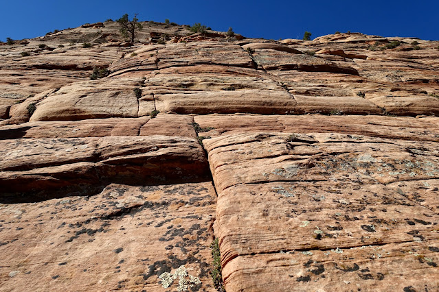
Half a mile beyond the junction you will pass to the south of a Navajo Sandstone wall with conical stone features marching across the top. Cross bedding on the slope changes direction every few feet. The rich color palette varies from cream to tan tinged with apricot. The wall has its own unique characteristics, and yet, it displays the signature of Navajo Sandstone. We were reminded of many similar structures on the Colorado Plateau. (THW, photo)

No words can recount the marvel that overcame me in this landscape. The great sweeps of rock, the captivating shapes, the brilliant hues, and the carefree act of walking on slickrock. Throughout my life I have traipsed through radically diverse landscapes in the American West and I'm on home ground in each one of them. (THW, photo)

Water Peak, 6,860', and Eye of Heaven
Walk up the stone draw of a tributary of Birch Creek with water collected in the pockets. At the top of a subtle rise at 7.9 miles, 6,460 feet, we came to the turnoff for Water Peak and the Eye of Heaven (also known as Water Canyon Arch). It was a three mile out-and-back to visit both features.
Studying the image below, Water Peak is the highpoint on the rim of rock, the divide between Squirrel and Water canyons. Water Canyon is the deep trench, image-right. Our first goal was the ranked summit. The trail, however, was going to the arch. It is useful most of the way to the peak. From the junction, hook a hairpin to the southeast. Once again the trail was more of a two-track.

The trail was easily followed until it went straight up into the rock at 6,600 feet. Eventually we met back up with the two-track. Weave through rock stacks with stellar displays of cross bedding.
At 6,800 feet we could see the summit ridge branching left to Water Peak so we left the arch trail and climbed southeast to the highpoint. Scramble up an orange block to the official crest at 9.0 miles. With a rise of 400 feet the peak offers a good vantage point overlooking the Canaan Mountain plateau that rolls on and on.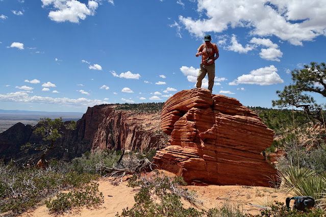
The Beehive has a massive west-facing alcove. There was an aha moment when we got a clear visual on the dome and realized it could be more easily mounted from the south. The next day this was confirmed by the owner of Willow Canyon Outdoor in Kanab.

We tried to bail off the peak directly to the arch but got trapped by a ravine. So we went north far enough to cross the ravine and intersect the arch trail. I left that navigation adjustment on the map intentionally. Keep in mind the arch is located at the top of the east wall of Water Canyon and that you'll give up 220 feet getting there.

We arrived at the Eye of Heaven at 9.4 miles, 6,620 feet. I have walked across many arches in my lifetime and this was truly one of the most notable. It certainly gets top prize for an adrenaline rush on this hike. I shot this image as I stepped onto the top of the arch, easily accessed. As you can see, the walkway is as much as four feet wide but it is off-camber, pitched toward the abyss. We were forced onto a narrow rib and there was some loose sand on the surface adding to the danger factor. While we both agreed that walking on the arch was a highlight of our hike, Earthline does not endorse activities where one slip of the foot could be fatal!

The arch is a massive slice of stone rising up at an angle. Unlike arches too fragile to bear the weight of humans, you will not harm the integrity of this structure by walking across it. Can you find the person in this photo?

It took some concentration to keep track of the arch trail on our return to the junction. Plus, the hike was starting to feel like it had an infinite number of short, steep hills in deep sand. We arrived back at the junction at 10.9 miles.
Canaan Mountain Trail to White Domes
The White Domes are 1.6 miles northeast of the junction, shortly beyond Point 6,973' on the Hildale quad. To begin, we walked up the throat of another magnificent stone draw. 
We are fortunate that the route to White Domes comes up through this sublime corridor. Those of us who spend a lot of time on the Colorado Plateau live for moments when elements are reduced to endless stone and sky. (THW, photo)

Leave the sandstone and ascend imperceptibly across a sage flat on a sandy two-track. Old growth ponderosa have taken hold on the high plateau. Through parted timber you will catch glimpses of the monuments in Zion National Park.

North of Point 6,973' the track turned southwest and soon White Domes came into view at 12.5 miles. How extraordinary! At roughly 6,960 feet, the domes are the highest point on this hike.

The small cluster of aeolian-crafted domes are predominately lunar white. Allow time for a thorough exploration of these decidedly remote domes while you are in the vicinity. (THW, photo)

Minute, wavy ledges in chalk gray and rusty tan retain fine grains of sand. (THW, photo)

From this lofty perspective the temples of Zion astound, including Mount Kinesava, The West Temple, and The Sundial.

We walked through troughs and mounted crests of stone.

We were ever attentive to our footsteps so they didn't break thin fins characteristic of cross bedding. (THW, photo) 
The fusion of color on the ground and the flawless blue sky was simply dazzling. (THW, photo)

Water Canyon
We left White Domes at 13.0 miles, 4.0 miles from our final destination, the Water Canyon Trailhead. A menagerie of trails and routes leave from the domes, none are signed. The Canaan Mountain Trail continues west to the high point of the mountain. There is more than one route to our first objective, "Upper Water Canyon." Our route was different than some of the trip reports I read later.
The one imperative is locating "Top Rock." There is one and only one route into the depths of Water Canyon and it plunges down from Top Rock. I don't care how fast you are, the next four miles to the trailhead are slow, primarily because navigation is so tricky. The track we were following hooked sharply southeast from White Domes.

We held the bearing and walked down a tributary of Upper Water Canyon. This was a massive expanse of slickrock without defining features. Follow your track! It would be way too easy to get lost on this mountain. We found two cairns spaced half a mile apart and between them we could have gone in any direction. We cruised down sheets of sandstone. Astounding!

Our tributary joined a much larger drainage, informally called Upper Water Canyon, at 6,440 feet. Concretions in the sandstone looked like iron raindrops.

We were mesmerized by water sculpted pouroffs, deep tanks, and pools. Recent rains had replenished the water pockets but don't count on them for your water supply.

At about 6,400 feet, you must leave the canyon on an extended bypass. Were you to keep going, the canyon plunges into two inescapable declivities. There was no cairn at this mandatory juncture and we got sucked into continuing downstream (so gorgeous). When the waterway made a hard left, we realized we'd blown by the turnoff for the bypass (downcanyon-right) and we backed up to find it. We left the drainage, hiked uphill, shown, stumbled around, and eventually found the trail bearing south.

We ascended 140 feet to Top Rock at 14.7 miles, 6,540 feet. You will know you have arrived given all the names carved into the boulder. The image below was shot from Top Rock looking east. Somehow, the Water Canyon Trail must plunge 1,000 feet down onto the canyon floor while clinging to the west wall cliff. Trail engineering is masterful. The pathway points one way and then counterintuitively switches 180 degrees, exploiting existing or engineered ledges. Pay close attention and take your time. The trail platform is thin and the drop is endless. Some hikers will experience a sense of mild exposure.

Leave the Canaan Mountain Wilderness at 6,400 feet.

The trail hugs the wall, working the edge, while diving down into the abyss. It is a superior example of trail construction in a tight space. Next time, I'd like to walk up the trail at the beginning of the hike in order to spend more time enjoying the feat.

This image illustrates why the bypass was necessary. Looking back upcanyon there are parallel impassible gashes.

This is a Class 2+ trail but there is one arguably low Class 3 move. Below, I am completing a six-foot spiderman scamper over to a log propped against a five-foot drop at the base of a cliff. (THW, photo)

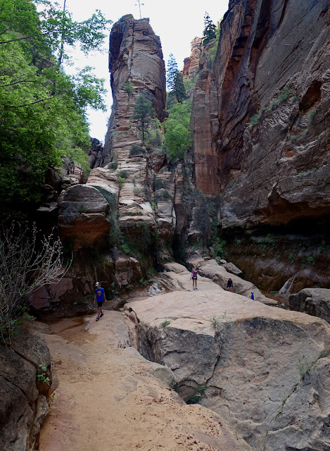
The walls of Water Canyon come together to create the ultimate pinch. (THW, photo)

At 5,800 feet we arrived on the canyon floor at the upper end of the pinch. It was a shadowy, powerful, and mysterious place. Surely another bypass was inevitable. (THW, photo)

Below, my partner is making some sweet moves into the inner canyon.

Indeed, a pouroff forced some more crazy maneuvering along a ledge high above the canyon floor. Look carefully and you will see the "Waterworks" at the next level.

We are giving this wondrous haven the informal name Waterworks. A weakness in the resistant layer on the east wall has created a wall spring 100 yards long. Water gushes out, the walls drip. Ferns grow from the rock. It is exquisite. For scale, notice a man standing on the large boulder, image-center.

Just 1.3 miles from the Water Canyon Trailhead, this flush and playful environment is understandably popular with casual hikers and locals. For most, it is their destination and turnaround.
In order to continue to the trailhead (or to explore the Waterworks, for that matter) you must walk through a narrow opening in the canyon walls just below the wall spring. We were able to rock hop but if the water is high, you'll get your feet wet. Joe's Guide (see Reference at top of this post) claims that, "Waterflow rarely hinders access, even during the spring runoff."

I marvel at the contrast between this watery world and the endless delights we saw all along the way on this hike.
(THW, photo)

Walk downstream for a short distance and then watch for yet another bypass downcanyon-right. You'll see a pathway up against the wall, working ledges once again. We got swallowed by the canyon (so cool!) and had to double back. Don't forget to scan the top of the east wall to see through the Eye of Heaven. 
It was evening when we concluded our hike and the wall possessing the Eye of Heaven was illuminated in golden twilight. (THW, photo) 
As we closed in on the Water Canyon Trailhead, shown, the hike concluded on a flat, firm, dirt footpath through the woods. Note: We needed the entire day for the hike described. We were out on the adventure for 11:15. If you'd like to cover these, and additional features on Canaan Mountain, I recommend backpacking.

No comments:
Post a Comment