Essence: Mollies Nipple is an isolated symmetrical Navajo Sandstone cone. The climb begins on a slab of brilliant white slickrock. The apex is composed of an
exceptionally resistant and colorful layer of iron-rich sandstone, a variation within the same formation. From US 89 between Page, Arizona and Kanab, Utah, the peak looks improbable, if not impossible. Five miles of deep sand walking on the access track is a long slog, followed by increasingly difficult challenges. No special skills are required for the Class 3 scramble on the summit block to the Moll Benchmark but exposure is extreme. Each climber will need to pause and consider whether the 30-foot near vertical wall with an effectively bottomless base is a risk they are willing to take. The hike is within the Paria-Hackberry Wilderness Study Area, a unit in the Grand Staircase-Escalante National Monument, administered by the Bureau of Land Management.
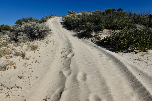
Travel: From US 89 turn north at mile marker 36.8. The turn is just east of a highway bridge. Buckskin Wash is the drainage south of the bridge and Kitchen Corral Wash is north of it. BLM 508 is nicely graded. However, just before a wash crossing at 7.7 miles, the sand is probably too deep for 2WD. At 10 miles stay straight, following a sign toward Mollies Nipple. At 11.3 miles turn right/east on a 2-track for 100 yards and park between two sandstone knobs. This is an excellent place to camp. Your mileage will likely vary. Note: Continuing on the road looks tempting to start but it soon is covered in deep sand negotiable only by OHVs. There is a turnaround at 0.8 mile if you want to give it a shot.
Distance and Elevation Gain: 11.0 miles; 2,200 feet
Total Time: 6:00 to 7:00
Difficulty: Sandy track for 10.2 miles; 0.8 mile off-trail; navigation moderate; Class 3 with serious exposure; Carry all the water you will need and hike on a cool day.
Map: Deer Range Point, UT 7.5' USGS Quad
Date Hiked: May 12, 2025
Quote: Everyone wants to live on top of the mountain, but all the happiness and growth occurs while you are climbing it. Andy Rooney
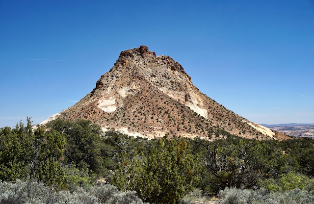
The Colorado Plateau is essentially one massive sheet of Navajo Sandstone cut into huge segments by river systems. It forms deep canyons, cliffs running on for miles, lost world mesa tops, unscalable domes, perpendicular bluffs, world famous arches...and Mollies Nipple, a curiosity that begs to be answered. (Thomas Holt Ward, photo)

Route: Hike roughly east on a sandy track to Pilot Ridge. Go left at the split and hike northeast to the end of the road. Ascend an open slope and gain the south ridge. It leads to a Class 3 chute that terminates on the summit ridge. Climb east to the vertex of the cone.

We camped amongst elder piñon and juniper at the two sandstone knobs, elevation 5,900 feet. Five miles to the east, Mollies Nipple was burnished in evening twilight.

Five miles on the sandy track is the shortest route to the peak so find some pleasure in the long approach. The road ascends gradually to the base of the mountain with many undulations.


We crossed a sagebrush flat. Morning sun rendered our quest a striking silhouette. (THW, photo)

Blue berries encircled Utah junipers, the most predominant single species of tree in Utah, covering nearly one-fifth of the land area. The berries are eaten by rabbits, coyotes, and birds. The trees have a rounded crown and forked trunk. They can live to be 650 years old.

Growing on the woodland floor were yucca, snakeweed, Indian ricegrass, ephedra, rabbitbrush, and pricklypear. Wildflowers were not abundant this season but the purple bush pea was having a good year. Cold-desert phlox offered a sweet contrast with the tan desert monochrome. (THW, photo)

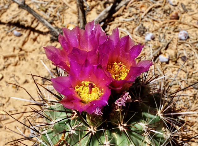
First place for vivid color was awarded to this Uinta Basin hookless cactus. (THW, photo)
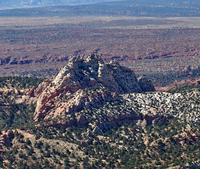
This was a hike of solitude. The only tracks evident in the sand were from local critters: lizards, snakes, rodents, bobcats, and rabbits. Round off on Point 6,355' at 2.0 miles where the opening photo was taken. Looking north, the South Swag basin extends to Nipple Lake. According to Ron Adkison, (Hiking Grand Staircase-Escalante and the Glen Canyon Region), John Kitchen established Nipple Ranch adjacent to the lake in 1879. The peak is named after his wife, Molly. Give up 260 feet and ascend once again to a low ridge above Box Elder Canyon. From the ridgetop you see the Grand Staircase phenomenon in action. Above and behind the White Cliffs are the Pink Cliffs of Bryce Canyon National Park.

The road splits on Pilot Ridge, 4.5 miles, 6,580 feet. The main road turned south and took most of the tire tracks with it. Take the north branch. But first, pause and consider your route on the cone. Variations are possible, especially since there is no guidance from cairns or social trail. It worked well for us to climb the fan slope in the center of this image until we made contact with the subtle south ridge. It delivered us to the one weakness that penetrates the summit ridge. (THW, photo)
Descend almost 100 feet, noticing the shiny black flat plates, iron concretions typical of Navajo Sandstone.
(THW, photo)

We went to end of the road at the top of a small rise, a full-on dune. Alternatively, the climb could be initiated at the base of the final pitch.
The road ends at 5.1 miles, elevation 6,620 feet. We rested among ponderosa pines. I stashed an extra liter of fluid to lighten my pack and changed into the approach shoes I'd been carrying. In retrospect, they were worth the trouble. The climb is 700 feet over 0.4 mile. We were there to savor and experience the mountain, not to rush, so we spent 1:45 round trip from this point.
There is more than one way to navigate on the cone. The one imperative on the lower mountain is getting set up to hit the south facing, white, ledge-filled chute. Our ascent route worked well and so we returned the same way. We began by crossing a swath of sand, heading toward the slickrock, image-right. (THW, photo)

The striking white slab is covered in rust-colored cap rock eroded from the upper mountain. We climbed northeast up an open slope, image-right.

Following our general rule of practice (ascend on a ridgeline unless forced off) we soon made contact with the south ridge.

The ridge is steep enough to dislodge loose rock. By selecting my footing carefully I found stable slabs and blocks. Let the fun begin. (THW, photo)

The terrain is steepest and loosest just below the chute.

The south ridge passes by a multi-colored wall. Variations in the type and proportions of precipitated iron oxides create a multiplicity of hues in Navajo Sandstone. Pictured, lime-yellow and blue lichen further enhance the vibrancy of the vermilion, tan, rust, black, and maroon wall.

I've been in plenty of nasty chutes. The term conjurers rolling boulders at the angle of repose. This break is a series of stable ledges. It is at once gorgeous and exhilarating. Low Class 3 climbing on the left side of the chute felt safe and protected.

The chute ends abruptly at a five-foot-wide gap in the summit ridge. (THW, photo)

The highpoint is to the east, image-right. We considered going straight up the spine but instead stayed just below the ridgetop for a short distance. (THW, photo)

The traverse to a safe route back onto the ridge is funky but intuitive--up, down, and around. It's a total blast.

The narrow ridge is airy and off-camber, slanted toward the south.

The summit block requires a 30-foot near vertical Class 3 climb with heart-stopping, potentially catastrophic exposure. (THW, 15 photo composite)

To initiate the climb, a solid clean ledge leads to a block that serves as a bridge to the wall.

This is a Class 3, non-technical climb with superb holds for both hands and feet.

However, it does take considerable courage to step out onto the wall. Before I assume this level of risk I always pause and have a conversation with the mountain I'm climbing. I show my genuine respect for the mountain by asking permission to climb. If I get an affirming vibe, I proceed. Considering the ten mile investment on the sandy road, we really didn't want to take a pass. This last pitch is not for everyone. Take responsibility for your safety. (THW, photo)

Arrive on the apex of the cone at 5.5 miles where you will find the Moll Benchmark placed in 1954. (THW, photo)

The apex is tiny but flat and thus, more comfortable than anywhere else on the summit ridge. The stones are covered in bird guano. With a rise of 1,251 feet and absolutely nothing impeding the full-circle field of vision, the views are expansive. I'm looking northwest toward No Mans Mesa and the White Cliffs. The Deer Range is image-right. The Pink Cliffs of Bryce Canyon are on the horizon. Navajo Mountain, distinguished by its softly rounded form, is visible off-image in the east. (THW, photo)

The cluster of sandstone pinnacles to the southeast host Starlight Arch. (THW, photo)
We didn't spend a lot of time on top because of high velocity winds. The gusts were so fierce I got blown over on the south ridge descent. This image looks from the peak at the semi-circular summit ridge. The access chute is directly across from the photographer. The descent from the block is a simple, comfortable downclimb, no more difficult than the ascent. When exposure is grave, I mitigate anxiety by not looking down any further than my next move. Upon returning to our gear stash, we both agreed that climbing Mollies Nipple was a spectacular and pleasurable adventure.
(THW, photo)

No comments:
Post a Comment