Essence: The four informally named Wolves Teeth are rapturous granite pinnacles located on the headwall of Pima Canyon between Table Mountain and Pima Saddle. Starting from the west they are: Table Tooth, Point 5,940', Barrier Tooth, and The Molar. Canine is the name we are proposing for Point 5,940', the most
northern of the Wolves Teeth spires. The airy fang is east of Table
Tooth (Peak 6,034') and northwest of Barrier Tooth (Peak 5,985'). Using standard interpolation, the elevation of Canine is 5,940 feet. The elevation of the shared saddle with Barrier Tooth is 5,780 feet. The rise of 160 feet is the height of the Class 4, nearly vertical, seriously exposed corner crack culminating on the crest. The Pima Canyon Trail comes within 0.6 mile of the summit. Off-trail, navigation through cliff bands is challenging and
slopes are steep. The peak register was placed by Ethel Staley in 1975. She named the point "Ethel's Wolf Tooth." In the past 50 years only eight parties have signed the register. Canine is within the Pusch Ridge Wilderness managed by Coronado National Forest.
Travel: From Tucson, drive north on Oracle Road, AZ-77. Pass Ina Road and turn right on Magee Road. Go 1.5 miles to the Iris O. Dewhirst Pima Canyon Trailhead. Or, from Ina Road take Christie Drive north for 1.4 miles and turn right on Magee. The generous paved lot is on the right. There is a drinking faucet but no other facilities.
Distance and Elevation Gain: 10.4 miles; 3,350 feet
Total Time: 8:00 to 9:30
Difficulty: Trail, off-trail; navigation challenging; sustained Class 4 crack with serious exposure; webbing recommended; carry all the water you will need and hike on a cool day.
Maps: Tucson North; Oro Valley, AZ 7.5' USGS Quads
Date Hiked: May 1, 2025
Pusch Ridge Wilderness Bighorn Sheep Closure: It is prohibited to
travel more than 400 feet off designated Forest Service trails from
January 1 through April 30, bighorn sheep lambing season. Canine is off-limits during that time period. No dogs.
Poem:
Poem:
Listen.
Are you
breathing
just a little
and calling
it a life? Mary Oliver
Are you
breathing
just a little
and calling
it a life? Mary Oliver
Both Canine and Barrier Tooth pose navigational conundrums even for the most seasoned desert mountaineer. As seen from the three-mile dam in Pima Canyon, Canine (image-center) is a stiff scramble. We have yet to find a non-technical route up Barrier Tooth. (Thomas Holt Ward, photo)

Route: This map shows navigation detail starting from the crossing of Pima Canyon at 3.8 miles. From the trailhead, hike northeast on the Pima Canyon Trail for 4.6 miles. Leave the trail and pitch north to elevation 5,600 feet. Contour northwest to a notch in the west ridge of Barrier Tooth. Downclimb through the notch and ascend northeast to the saddle. Climb northwest up a wide crack to the summit. On your return, you may take the optional blue-line route down the streamway in Pima Canyon. Note: This map was built on CalTopo using the Map Builder feature with LiDAR-enhanced shading.

From the Pima Canyon Trailhead, elevation 2,920 feet, the footpath
threads through private land on a
thin easement bearing generally northeast toward the canyon. Cross
into the Pusch Ridge Wilderness just before the Pima Canyon Trail sign at 0.4 mile.
I am assuming that if you are making an attempt on Canine you have been on this trail many times and that you are aware that the sign should read "Mount Kimball," not "Kimball Peak!"
Route: This map shows navigation detail starting from the crossing of Pima Canyon at 3.8 miles. From the trailhead, hike northeast on the Pima Canyon Trail for 4.6 miles. Leave the trail and pitch north to elevation 5,600 feet. Contour northwest to a notch in the west ridge of Barrier Tooth. Downclimb through the notch and ascend northeast to the saddle. Climb northwest up a wide crack to the summit. On your return, you may take the optional blue-line route down the streamway in Pima Canyon. Note: This map was built on CalTopo using the Map Builder feature with LiDAR-enhanced shading.

Pass the crested saguaro holding forth above the trail at half a mile. The first of numerous wash crossings is at 1.1 miles. During a wet winter Pima Canyon's
drainageway is often flowing but don't count on it as your emergency water source. Pass the unsigned turnoffs for Prominent Point, The Cleaver, and Big Horn and Table mountains. At 3.0 miles the trail crosses a sheet of Catalina Gneiss with five mortar holes ground into the bedrock. (THW, photo)

A few steps further on poisonous sacred datura was blooming beside the dam constructed in
the 1960s by Arizona Game and Fish. Casual hikers typically
turn around there. (THW, photo)

Three of the Wolves Teeth are visible from the trail shortly above the dam--Canine, Barrier Tooth, and The Molar. Canine is climbed from the shared saddle with Barrier Tooth.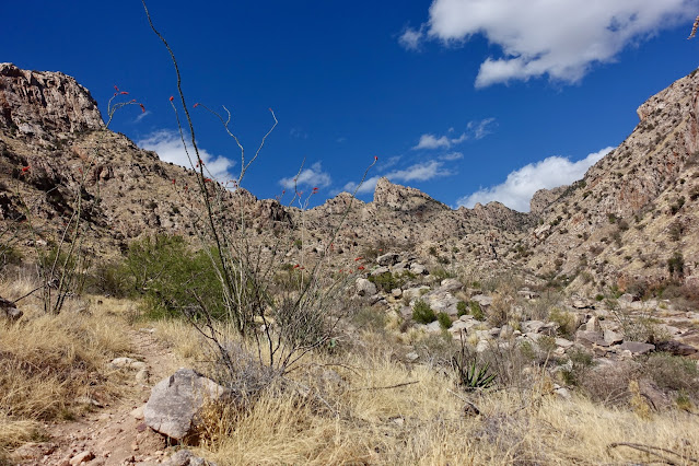
At 3.8 miles the trail crosses over to the southeast side of the canyon. This is the turnoff for Table Tooth as well as the conclusion of the creek walk mentioned at the end of
this post.

Pass the turnoff for the route up Valentine Peak and drop into a southeast tributary. Recross the main channel at 4.3 miles on washed-white slabs of Catalina Gneiss. This is the upper end of the creek walk.

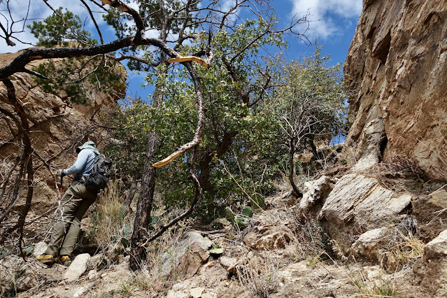
Canine demands a long approach on trail followed by steep off-trail pitches. Don't leave the Pima Canyon Trail early. The terrain is too steep and too loose. Below, climbers are on the trail picking up elevation. Soon, they will leave the track and hang a 90 degree left. Notice the cracked block in the center of the image below. The route passes just to the east of it.

Leave the trail at 4.6 miles, elevation 5,140 feet. Climb north toward Barrier Tooth for 500 vertical feet. The climbers below are about to cut to the right of the block mentioned above.

Search out passages around small cliff bands in Class 2 terrain.

At 5,600 feet, 4.8 miles, start contouring northwest for 0.15 mile. Gingerly side hill across the slope below Barrier Tooth through high grass and unstable rock. Trekking poles are helpful. At 5,600 feet you will head a gully. If you are much lower in the gully it will be extremely difficult--chossy and troubled with cliffs.

The route must cross the west ridge of Barrier Tooth. There are a couple of weaknesses. The higher notch will leave you gazing into thin air. Look for the break pictured below.

A small brushy gully leads to the proper notch.
Stand in the notch at 4.95 miles. This imperative feature looks unlikely until you are right on it. Other routes have been explored. It is not possible to cross the ridge further west. You have to nail this notch. From the top of the cleft you can scope out the ascent to the saddle between Canine and Barrier Tooth.

The 20-foot downclimb is Class 3. There are plenty of features but the holds are tiny.

This image looks back up the north side of the notch. (THW, photo)

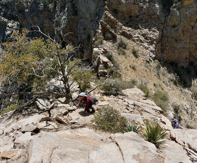
At the base of the downclimb cut to the northeast under Barrier Tooth. (Don't continue down the ravine.)

It is quite exposed initially. Be mindful. Below, I am returning to the notch. Head for the saddle while holding to the right to stay out of overly steep terrain. (THW, photo)

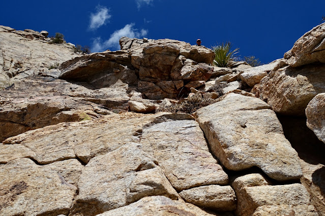
As you climb to the saddle you will be faced with a stunning (and intimidating) view of the vertiginous corner crack climb to the summit. Our route does a Class 3 scramble from the saddle up the south face for 80 feet and then moves left onto the Class 4 wall. All four of the Wolves Teeth are composed of Wilderness
Suite Granite and Gneiss. The trustworthy rock is
characterized by widely spaced vertical joints.

We know that Barrier Tooth has been successfully climbed but we are still searching for a non-technical route amongst the rock rage. (THW, photo)

Gain the saddle at 5.1 miles, 5,780 feet. We left our packs and trekking poles on the saddle. (THW, photo)

One person in our group of four clambered into the crack directly from the saddle. I found it easier to begin by scrambling up the south face.

This was great sport with minimal exposure. (THW, photo)
The rock was dependable and the holds plentiful.
Move left into the crack with another 80 feet to climb. In this image I am returning to that transition spot. (THW, photo)

We were grateful for assistance from a couple of short stout trees rooted on the upper wall.

Holds were generous at first but they became stingy and the wall more vertical for the upper 30 feet. Our best climber went ahead without protection and tied a strap to one of the two trees at the top of the wall.

I had a hand wrapped around the webbing for security. The downclimb would have been testy for me without the strap. (THW, photo)

This image illustrates the angle of the pitch. A slip could well be fatal. (THW, photo)

There is no way I could have climbed Canine without advance work from a couple of Pusch Ridge aficionados. Thank you, Gregg and Mike, pictured. It took them four exploratory trips to ferret out this route. They shared it with my partner who, in turn guided me up Canine. (THW, photo) 
From the top of the crack the summit is to the immediate west.
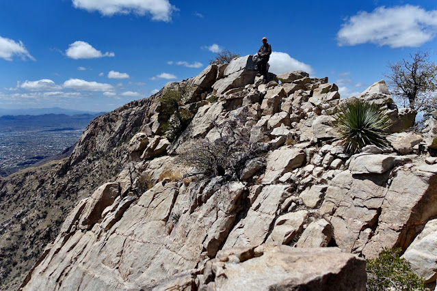
Arrive on Canine at 5.2 miles. It is an airy, skinny, slightly awkward stone zenith. (THW, photo)
The peak register was placed by Ethel Staley in 1975. It is a few stapled sheets in a small glass jar. Ethel's husband Dean climbed the point a few months later. This same couple is credited with naming Valentine Peak in the early 1980s. In the fifty years that have lapsed since Ethel left the register there have been long gaps between visits. Note that in 1988, two men rappelled off "Bitter Tooth" (Barrier Tooth) before scrambling up Canine. By then Ethel's name had lapsed into obscurity and we therefore took the liberty of suggesting a name consistent with the Wolves Teeth theme. (THW, photo)

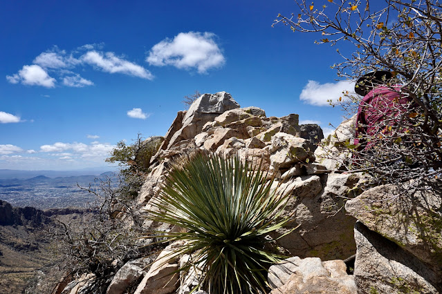
The views are spectacular, no surprise there. To the immediate west is Class 5 Table Tooth, its stone essence looking decidedly viscous. (THW, photo)

While standing in the Table Tooth-Canine saddle a few years back it was immediately obvious that we were not climbing Canine from the west.

Northward, the range hurriedly collapses in Catalina State Park. Midway, Point 4,262' offers astonishing views of the savagely ragged Pusch Ridge pandemonium.

Gazing southeast, to the right of Barrier Tooth are Finger Rock Guard, Finger Rock, and Prominent Point.

The subsidiary peak was a nice sitting perch. At my back is The Molar. (THW, photo)

This image looks down on the crack but omits the challenging, upper segment.

A blooming claret-cup cactus near the saddle was an alluring distraction. (THW, photo)

On our return we did the resplendent stream walk noted on the map with a blue line. Treat yourself to an internal view of the Catalina Gneiss of Pima Canyon. There's some boulder hopping so if you are worn out, stick to the trail.

This final image was shot from The Molar in 2023. If you consider yourself more of a hiker than a climber, the Class 3, slightly exposed Molar may be your ticket to one of the Wolves Teeth. The three more demanding Wolves Teeth pinnacles, Barrier Tooth, Canine, and Table Tooth, are pictured in front of Table Mountain. (THW, photo)

2 comments:
Great writeup. I hiked Table Tooth a few years ago and there was really nothing above a class 3+, if you go the way I did. Maybe one low class 4 move over a 5 foot ledge but the grips were good. Clearly Table Tooth was easier than this one.
https://peakbagger.com/climber/ascent.aspx?aid=2133508
Mike, Thanks for your comment. You must have found the elusive workaround for that Class 5 wall I went up on Table Tooth. I know it's there but I have not found it...or, dude, maybe my Class 5 is your Class 3+! Debra
Post a Comment