Travel: From Silverton drive north on US Route 550 toward Ouray for two miles. At the sign for the South Mineral Campground bear left onto a good dirt road. In 4.2 miles, park in a large lot on the right at the trailhead. There is an outhouse but no water.
Distance and Elevation Gain: 8.0 miles; 3,600 feet of climbing
Time: 4:30 to 6:30
Difficulty: Trail; navigation easy; mild exposure; slippery trail on approach to Swamp Pass
Map: Ophir, Colorado 7.5 USGS Quad
Latest Date Hiked: August 27, 2024
Historical Note: The San Juan Mountaineers, founded in 1912, assigned an alphanumeric designation to select unnamed peaks. "V" means the peak is on the old 15-minute Vermilion quad. "T" stands for Telluride, and "S" for Mount Sneffels. Reference The San Juan Mountaineers' Climber's Guide to Southwestern Colorado, out of print, published in 1932 by Dwight Lavender after whom Lavender Peak in the La Plata Mountains was named.
Quote: Whatever you think you can do or believe you can do, begin it. Action has magic, grace and power in it. Goethe
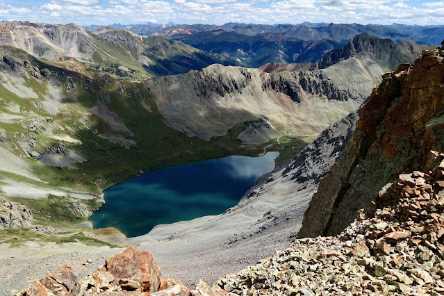
From the summit of V2 look out over some of Colorado's most challenging and visually captivating mountains. Island Lake is directly below. Ice Lake's brilliance is partially seen beyond V4's southeast ridge.


The hike to Ice Lake has gone viral on the world stage. This shot was taken in 2014. Now, in mid-summer vehicles typically overflow onto the access road by 8:00 am.

From the trailhead, elevation 9,840 feet, switchback up the generous path on an excellent surface. Flora is rich on the woodland floor of the subalpine fir and aspen forest. Hop across Clear Creek on its mad rush to South Mineral Creek at 0.5 mile. At 0.9 mile, leave the trail on a short spur to see the Clear Creek cascade.

Flowers take over in a clearing and then the track enters a thick stand of mature conifers at 1.6 miles. In this forest the Hardrock 100 course comes in from the left and joins our route to Island Lake. This hardcore footrace begins and ends in Silverton, linking Telluride, Ouray, and Lake City with 33,992 feet of climbing over 100 miles.

At 2.2 miles, the secondary trail to Island Lake takes off to the right at 11,460 feet. This juncture is intermittently marked with a cairn and is easy to miss. It is located at the very beginning of Lower Ice Lake Basin. Pictured is the south-facing slope the trail climbs.

In the west, the dramatic triumvirate that heads the Ice Lake Basin commands and holds attention through the remainder of the hike. Pictured are Fuller Peak, Vermilion Peak, and Golden Horn. Vermilion, 13,909' (LiDAR), is ranked No. 76 in Colorado.

The track begins due north then turns briefly northeast to contour across a hillside under a cliff band. Once past this obstruction the thin treadway switches west. Mid-summer, the flowers are truly magnificent. Featured in this image are orange sneezeweed, sulfur and rosy paintbrush, alpine avens, bluebell, and American bistort. Bordering a rivulet are brookcress and Parry's primrose. As you approach Island Lake, handsome Ulysses S. Grant Peak, 13,778', consumes the sky.

Step across the outlet of a shallow pond. Just off the trail in the Island Lake Basin is a big boulder, 3.2 miles, 12,460 feet. It affords a nice view of the lake and V4, Peak 13,540'. From here V2 is less than an hour away.

In 2014, a pica in the vicinity of the boulder posed patiently for photos. (Thomas Holt Ward, photo)

Pictured below is the trail to Swamp Pass as seen from the boulder. The pass is on the right side of the gendarme image-center. After passing through red scree the trail splits. Stay low on the proper switchback to mitigate further erosion.

There are wildcat trails in this area. Just before reaching the pass go right of this minor outcrop. The last couple hundred feet are steep and slick on resistant soil. Trekking poles are helpful.


Once I did a thru-hike key exchange on the Hardrock 100 course. I went over Swamp Pass and down into Swamp Canyon. Plunge step about 500 feet, pictured, and locate a cairn marking the trail on an alluvial fan. Finish on the Ophir Pass Road at Iron Spring.

To reach V2, turn east on a slender social trail and pass by the Joel Zucker memorial. He was a Hardrock competitor up until his death in 1998. The Goethe quote cited above is etched on the plaque.

The footpath stays on the west side of ridge humps, little piles of red scree, pictured looking back. Mighty U S Grant rises to the west of Swamp Pass. (THW, photo)


Find the summit cairn at 4.0 miles, 13,319 feet. The peak falls off precipitously on either side with sheer cliffs on the north face. (THW, photo)


This photo was shot in September, 2024 from Ulysses S. Grant Peak. V2 is image-left.

No comments:
Post a Comment