Travel: From the US 550/160 intersection in Durango, drive 41 miles north on US 550. One mile before Molas Pass, just shy of MM 63, turn right/east at the Andrews Lake sign. It is 0.7 mile to lakeside parking with an outhouse.
Distance and Elevation Gain: 7 miles, 2,600 feet of climbing
Time: 4:45 to 6:15
Difficulty: Trail, off-trail; navigation difficult; Class 3 scramble with significant, sustained exposure
Map: Snowdon Peak, CO 7.5' USGS Quad
Latest Date Hiked: September 3, 2019
Quote: By now this was home in the simplest sense of that word. It was, I mean, the place where one opens one's eyes without surprise. Home can mean a great deal more, but it can hardly mean less. Joseph Wood Krutch
Snowdon Peak and Meadows in mid-summer. (Thomas Holt Ward, photo)


From the parking lot, 10,750 feet, walk across the bridge on the west side of Andrews Lake. Step up to the right onto the generous, well-engineered, heavily compacted Crater Lake Trail.

The treadway enters the Weminuche Wilderness and then switches gently up through deep woods decorated with a diverse array of wildflowers. A trail register at 1.1 miles marks the junction of the main track which heads southwest on its five mile journey to Crater Lake and our spur to the left. Top out on a limestone ridge overlooking "Snowdon Meadows." For those not traveling on to the peak there is much to explore in this moist area.

The water in the meadow drains into a swallow hole, or swallet, a limestone geological feature. Karst, a dissolution of limestone, forms rock runners that compartmentalize determined tundra. There are even a few caves small people can squeeze through if they dare. Be truly amazed, for a fault created a one billion year gap between the limestone formation and the much older quartzite (and a smattering of schist), that comprises Snowdon's ridge and massif.

This is surely the finest meadowland in Colorado. Walk along the trail and find some uncommon flowers such as burnt orange agoseris. Elephant head and American bistort saturate the landscape. As a friend said, "Elephant heads with their haunting color own this place."

Summary of the Climb
The low ridge at 11,200' is a good place for climbers to take a bearing on Snowdon. The safest and most pleasurable route is irrefutably traversed from north/left to south/right. In brief, walk across the meadow and into the woods on a social trail. Pitch up the green swale to the north ridge. Climb the ridge to the near vertical wall at the summit block. Contour around on the backside/east to reach the peak. Walk down to the double notch, the obvious "W". Climb the wall on the south side of the W. Continue on to the saddle. Descend a talus field and return along the base of the mountain, rejoining the trail. The deep rift just left of the summit is the Naked Lady Couloir, the gnarly skier's winter plunge. The West Buttress Route is right of Naked Lady. N1 is image-left.

The Climb: North Ridge to South Ridge
Cross the meadow on a spongy, boggy trail staying left of the stream. The thin track enters the woods and while fallen trees may discourage, this unmaintained trail will guide you across two more meadows broken by patches of forest. If the trail is indistinct in the boggy areas, search it out on the other side. The path leads to a broad, green swale. Poles are helpful for this steep, slippery, strenuous slog. The image looks down the pitch. Note: By 2019, there was a serviceable trail all the way up the gully.

As the grade decreases, work your way to the southeast/right, onto a westerly rib.

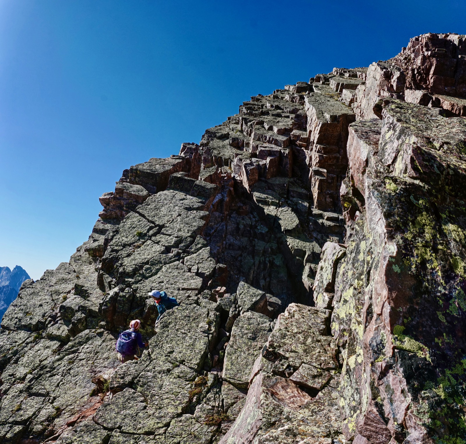
A social trail goes up through dark, sharp-edged rock to Saddle 12,600'. If you wish, stay on the ridge top, contouring just before the saddle. The glorious, green tinged, quartzite dragon scales are revealed and even more fun commences. (THW, photo)

Stay on top of the dragon's back, right on the ridge. The exposure is a little raw, especially where bedding planes fall off to the west, but the holds are excellent and the rock is solid.

Obstacles halt progress about 150 vertical feet from the summit. Some will choose to divert from the spine at the base of the "Green Ramp", a distinctive strip of grass on the east side of the ridge, shown below. Somewhere in this vicinity, depending on your comfort level, leave the ridge. Now on the east side of the mountain work south on quartzite ledges. There may be a few cairns and signs of trampling on this standard route.

As always, leaving a ridge increases the danger and on this summit block a fall could be catastrophic. Climb methodically and deliberately. Stay on a slightly rising traverse of ledges. Do not be seduced by any thought of going down and around. Test all holds; there is plenty of good rock.

It is possible to scramble further up the ridge before joining the standard route. The image below was taken from the top of the Green Ramp. Climb to the base of the cracked slab. Wedge your feet into the cracks and climb beyond the slab. (THW, photo)
Do a high Class 3 exposed down-climb to the standard route. (Chris Blackshear, photo)

All routes from the vicinity of the Green Ramp lead to a singular crack, or seam, seen in the image below. While my son is deftly taking the normal course, I prefer to squeeze through the slit next to the wall. This unmistakable stone and dirt ramp will direct you onto the final summit push. It is 50 additional, relatively safe yards to the crest.

The climbers below are on a viable alternate route. (THW, photo)

After such a difficult approach, it is startling to be standing on an expansive and welcoming summit with an unobstructed vista (3.3 miles from the trailhead). Catch your breath for the trip home has its own precipitous peculiarities. North is Molas Lake and the town of Silverton. (THW, photo)

The Grenadier Range and Needle Mountains are east of the deeply entrenched Animas River. (THW, photo)

South Snowdon must be saved for another day and approach because the ridge between the two peaks is interrupted by an impassible cliff and multiple towers.

To the southwest are the Twilights of the West Needle Mountains; Potato Hill, aka Spud Mountain; and arguably Durango's most popular peak, Engineer Mountain.

For those who travel on US 550 frequently and look wonderingly upon Snowdon and the W, to traverse the south ridge is deeply satisfying. From the summit, walk down the rounded south-southwest ridge on broken quartzite. The ridge narrows and steepens to meet the top edge of the north notch in the W. Drop about 100 feet off to the east where there are obvious signs of travel. Favor the south wall. Be careful not to descend any further than necessary before curving around to the floor of the notch. At the pinnacle in the center of the W, climb slightly and contour around it on the west side (depicted in this image with US 550 in the distance.). Drop down a short, dirt gully searching out small holds. No slipping allowed! Stand in the south notch.

The Wall, the final Class 3 challenge, is immediately before you. Climb the near vertical face. (THW, photo)

At the top there is one airy move which even a short person can stretch out and make. If the gap is too intimidating, it can be avoided with some clever scrambling. (Chris Blackshear, photo)

An alternative route exists. The Rabbit Hole, east of The Wall, is identified by a chockstone suspended over the gully. It is a perfectly workable slither and scramble, not as much fun. I am watching a friend emerge from the hole.
(THW, photo)

From here, it is an easy tromp down to Saddle 12,700'. Large blocks of unstable talus will jostle as you drop 500 feet to the tundra. When a friend complained, I made a metaphorical retort. "This talus field would be boring if none of the rocks rolled. It's kind of like life. Rocks roll out from under you now and then." Toward the base of the rock pile you will hear one of Snowdon's best features, one of the most distinctive sounds on earth, water running under talus.
(THW, photo)

Walk north a mile along the base of Snowdon, passing "Heart Lake" on its left. Cross the outlet and scamper down gigantic steps of tundra and talus aiming for the woods, crossing a stream just before meeting the ascent trail. Retrace your steps to the trailhead.
West Buttress Approach
I climbed the West Buttress in 2010 with three friends, guided by John, navigation wizard. This is mostly a Class 3 scramble with some Class 4 moves and 900 feet of non-stop, serious, no-nonsense exposure. Helmets recommended.
Use the trail as described above but leave it to walk south along the base of the mountain, up the talus field to the cone at the bottom of the rib just south of the Naked Lady Couloir, the deep rift north/left of the summit. The route eventually moves left to cross the lesser gully, shown, that terminates before reaching the base of the mountain.

Ascend the face just north of the cone starting on the scrap of tundra. Zigzag up 40 feet and move right to the crest of the rib. Stay on the spine until the angle decreases. The rib will intersect a shear, narrow gully; stay to the right of it as long as reasonable. After climbing about 500 feet, you must drop into the chute where there is a viable Class 4 exit to the north. Boulders are big and the holds skimpy.

You will emerge on another rib at the edge of the dragon's scales, quartzite bedding planes. Pick your exhilarating way to the summit on a route most pleasing to you. This image, with Andrews Lake below, was taken near the crest of Snowdon. Our group flowed up the Buttress in 50 minutes, making it look easy. That is a tribute to our able route finder.

North Snowdon (N1), Peak 12,628'
N1, sometimes referred to unofficially as North Snowdon, is located 0.3 mile north of the 12,340 foot Snowdon saddle. With 288 feet of lift from the saddle (just 12 feet shy of the 300 foot guideline), it is an unranked summit, a subsidiary peak of Snowdon. However, it has a lot going for it. The views are almost as spectacular as the parent mountain's and it is a Class 2 hike with no scrambling or exposure. Roundtrip from Andrews Lake Trailhead is 6.0 miles with 2,000 feet of elevation gain. 2022 Note: Based on new, more accurate measurement technology, LiDAR, N1 has been elevated to ranked Peak 12,647'. The saddle elevation is 12,334 feet, lower than interpolated 12,340 feet, giving N1 a rise of 313 feet.
Begin by following the trail toward Snowdon. Upon reaching the top of the swale walk east to the saddle. Growing amongst slate fragments is old man of the mountain. The alpine sunflowers all have their compasses out pointing forever east.

There is plenty of room to wander around admiring quartzite running through the tundra.

The crest is located at the south end of a ridge extending to Point 12,540' and beyond. These hikers have passed the highpoint; walking on the razor ridge is optional.

On the topo, Point 12,540' looks like an easy walk but actually it would be a tricky trek crossing slanted slabs of quartzite.

The peak register is located in the summit bivouac. Big chunks of milk-white quartz are prevalent. East is the Grenadier Range and the Needle Mountains. (THW, photo)

N1 affords a unique perspective on Snowdon Peak. If you wish you may descend west from the summit along the north edge for a short distance before returning to the trail at the top of the swale. (THW, photo)

Many choose to while away the day with a line in the water at Andrews Lake, seen below. Others picnic in wondrous Snowdon Meadows. A few succumb to the irresistible allure of Snowdon Peak and return to climb year after year. Regardless, some day you will open your eyes without surprise and you will be home.

6 comments:
Any chance you have a map/picture for the first route like you do for the first image of the West Buttress approach? I attempted Snowden today and made it to the big boulder field and couldn't figure out where to go from there
On Debra's behalf: If I understand you correctly, you're looking for more pictures of the West Buttress route? Unfortunately, pictures (or even a GPX track) are not very helpful. It's possible to find your way up with this general description, but the best way is to get someone who knows it well to show you in person. Tomas.
I just wanted to say how much I appreciate your blog! I use it all the time for my hikes. Your mileages, descriptions, and pictures are always dead-on and easy to follow than anything else I've found.
Thank you!
I am delighted that Earthline is proving to be useful. Thank you for your kind comment. Debra
You're the best!
Namah!
Head bowed,
Steve, My heart is fluttering and tears well up in my eyes. Debra
Post a Comment