Travel: From Durango, drive north on US 550 about 47 miles to Silverton. Continue north toward Ouray. Pass under the power lines and watch for the Ophir Pass sign, 4.8 miles from Silverton. Make a left and go downhill on San Juan CR 8. Cross the Mineral Creek bridge. Bypass the first road on the right. Take a hard right on the dirt road 0.4 mile from the highway. The road is rocky and narrow but 2WD vehicles carefully driven should reach the trailhead in another 0.7 mile. There is room for three vehicles on the right. Overflow parking is just up the road. Update: arrive by 7 a.m. to snag a parking place. Exit by turning around or fording Mineral Creek. Allow 1:15 from Durango.
Distance and Elevation Gain (Roundtrip): 6.6 miles with 2,550 feet of climbing to the lake; 8.2 miles and 3,000 feet of gain to Pass 13,058'; 9.0 miles and 3,250 vertical feet to Peak 13,300'
Time: 4:00 to 6:30 depending on destination
Difficulty: Trail, off-trail; navigation moderate; mild exposure and scrambling on Peak 13,300'
Maps: Silverton; Ophir, Colorado 7.5' USGS Quads, or Trails Illustrated No. 141: Telluride/Silverton/Ouray/Lake City
Latest Date Hiked: August 10, 2019
Poem:
Should your glance on mornings lovely
Lift to drink the heaven's blue
Or when sun, veiled by sirocco
Royal red sinks out of view –
Give to Nature praise and honor
Blithe of heart and sound of eye
Knowing for the world of color
Where its broad foundations lie.
--Goethe
Brilliant sapphire Columbine Lake from Peak 13,300' in late September. (THW, photo)

Route: The trail begins 0.7 mile north of the Ophir Pass Road and bears west to the lake on the Black-Line Route. In Mill Creek Basin, take the standard trail or the high trail to the lake. Additional options: walk to Pass 13,058' (Blue-Line Route) or climb Peak 13,300', staying on the Black-Line Route. The Red-Line, or Slidepath Route, is a challenging off-trail option from a different trailhead. Not shown on this map is the route from Porphyry Basin.

The sign for the Columbine Lake Trail is across the road and up a few paces from the parking pull-out at 10,360 feet. The compacted, zigzag track is steep from the get-go, pitching up 1,000 feet per mile.
The forest, thick with conifer, limits visibility. Mid-summer, a spectrum of woodland flowers distracts from the effort: myrtle blueberry, heart leaf arnica, parrot beak and fern leaf lousewort, geranium, mountain parsley, osha, orange sneezeweed, and Whipple's penstemon.

Timberline in the San Juan Mountains is typically around 11,500 feet. Reach that elevation in 1.2 miles and emerge from the forest. I always experience this as a heart-leaping moment. If anything, the time spent in the shrouded woods accentuates the thrill. The thin basin carries a tributary of Mineral Creek. The route uses this small watershed to attain Mill Creek Basin which is, unfathomably, even more spectacular.

The path weaves through thick mats of alpine avens, ubiquitous tundra producer. Adding to the chromatic palette are geyer onion, kittentails, columbine, rosy paintbrush, corn husk lily, veronica, and snow buttercups. Looking at the image below, the trail can be seen crossing the green slope and making for Pass 12,520', image-right.

Around the corner is a scene better than imagination can contrive. (THW, photo)


The left fork is the high trail. Fragments of track are visible in talus on the high route as you head southwest and then west. Cairns are occasional. If you have a decent sense of direction, this segment is dramatic and rewarding; the bench that cradles the lake is visible all the while. The trail is more obvious when sheets of snow have melted out.
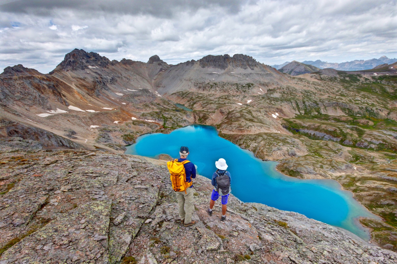
Columbine Lake remains a mystery and so anticipation crescendos until 3.1 miles when blue jolts the visual field. On each visit, it seems the lake dons a new hue, from shadowed to dazzling. (Thomas Holt Ward, photo)

On a cloud-racing day in September, the reflective, multi-hued lake is dynamic chromatism. (THW, photo)

The botanical name for our Colorado blue columbine is Aquilegia caerulea. On a cloud-free day in autumn, crystalline cerulean will envelop your entire being. When the land is free of snow, it is adventure enough to walk around to the south side of the lake where this image was captured.


Cross the dam at 3.4 miles and walk at lake level to the inlet on the west side. Climb about 100 feet onto a prominent bench and contour around to the mixed grass and scree incline, pictured below. It is a quick, relatively easy ascent to the surprisingly thin saddle at 13,100 feet. From there, mount 120 feet up a scrabbly west-facing slope.

Continue east to the base of the summit block. There are three routes to the crest, climber's choice. The east approach is Class 2+ with some exposure and loose rock, typical of San Juan volcanics. The west wall is a more protected Class 3 scramble. Or, scale the challenging center crack, shown. Top out at 4.6 miles.

The peak affords an unobstructed view of turquoise Columbine Lake, window to another world. Peak 13,300' is the Guardian of the Lake. Or, perhaps the living lake guards the mountain. Stone and water are intertwined forever in a union of opposites. (Chris Blackshear, photo)
Return as you came. Or, if you want a playful alternative, descend on the beguiling rib of stone that swirls down to the lake. Lookout Peak, 13,661', is just right of image-center at skyline.

The standard trail leaves from the other side of the dam. It swings east and holds the 12,500 foot contour back to Pass 12,520'. (This image depicts a hiker approaching the lake at the dam. THW, photo)

Pass 13,058': Anyone who walked to the lake can hike to the pass. It is 1.6 miles roundtrip on the Blue-Line Route and adds 450 feet of vertical. Backing up a bit, the image below shows the pass from the standard trail approaching the lake. The pass is located image-center, right/north of the serrated ridge.

Cross over the dam at 3.3 miles. Hop the stream flowing from two ponds. Then climb pleasantly and gradually to the pass as the landscape undulates. Reach it at 4.4 miles and look over the other side into another world. Lewis Lake dwells in the upper reaches of Bridal Veil Basin. Lewis Mine is just below the lake. Directly across is massive Wasatch Mountain; La Junta peak is to its right. World famous Bridal Veil Fall is in the trench on the right. Telluride is 4,000 feet below the basin. Toothy towers and Point 13,674', below, are stalwart under an ominous sky.

Return to the standard trail by either going back as you came, or cutting across directly as shown on the map above. Don't get sucked inadvertently too low in the Mill Creek drainage. Parry's primrose is having a banner year.
(Chris Blackshear, photo)

Rejoin the standard trail and let it take you back to Pass 12,520'. (Point 12,692' east of the pass is a stellar vantage point. It is a mellow 0.4 mile out-and-back. No exit to the east!) Below, hikers are descending the access basin before plunging back into the forest. Silverton is tucked in below the southern slopes of Anvil Mountain, image-right.

Color is the first principle of Place. Ellen Meloy
2 comments:
We hiked to the lake today, parking at the trailhead. I’m wondering how you measure distances for your hikes. Our total (no detours) came to 7.7 miles but I was using an app on my iPhone (Map My Fitness) so probably not very accurate. Not many people on the trail which was nice. Do you know the story behind the dam at the lake? It was a tough hike, but the reward was great. Maybe we will do this in the summer to enjoy the wildflowers next time.
Debra primarily uses a Garmin GPS for the stats, but we also often cross-check the mileages with the devices of companion hikers. If there's any doubt, we also use Caltopo to get another estimate directly from the topo map. Individual devices do sometimes produce anomalous readings, but we're pretty sure about this one. Thanks for reading!
Post a Comment