Essence: Calico Peak presides over the Paria ("Pahreah") Townsite inhabited from 1870 to 1929, and more recently used as a location for filming Westerns. The lower slopes of Calico are composed of brilliantly colorful Chinle Formation. The relatively short hike begins in a small canyon with tight, sinuous Chinle narrows. The butte-like summit is armored with an encircling barrier wall. The charm of this hike is scaling a weakness in the escarpment granting access to the extended crest. The hike is in the Paria-Hackberry Wilderness Study Area, a unit within the Grand Staircase-Escalante National Monument, administered by the Bureau of Land Management.
Travel: Between Page, AZ and Kanab, UT on US 89 there is a sign posted for Paria Townsite and a historical marker at mile marker 30.8. Turn north on BLM 585 and cross a cattle guard right away. The graded track is prone to washboard. Enter the GSENM. The road comes to a Y at 4.4 miles. To proceed directly to the start of the hike take the road to the left, a shortcut to BLM 584. The right branch goes by the Paria Movie Set Day Use Site with picnic tables and a pit toilet. (The movie set was destroyed by fire in 2006.) 2WD vehicles should park there, adding about a mile each way to the hike. Take the first left after the day use site on BLM 584, Paria Breaks Road. Enter the Wilderness Study Area. Wash crossings are sharp and deep requiring 4WD high clearance. After the fifth crossing, open and close the gate. At 5.3 miles, the road hooks sharply left. The access canyon is on the right at the apex of the bend. We parked in a one-vehicle pullout just before the canyon.
Distance and Elevation Gain: 5.2 miles; 1,200 feet
Total Time: 4:00 to 5:00
Difficulty: Off-trail; navigation moderate; Class 2+ with mild exposure at the base of the cliff wall.
Maps: Fivemile Valley; Calico Peak, UT 7.5' USGS Quads
Distance and Elevation Gain: 5.2 miles; 1,200 feet
Total Time: 4:00 to 5:00
Difficulty: Off-trail; navigation moderate; Class 2+ with mild exposure at the base of the cliff wall.
Maps: Fivemile Valley; Calico Peak, UT 7.5' USGS Quads
Reference: Thank you Kent and Allison Couch for an electrically enthusiastic and informative trip report on Calico Peak. See the end of their post in Beyond My Couch for a link to a GPS track.
Date Hiked: May 11, 2025
Quote: Color! What a deep and mysterious language, the language of dreams.
Paul Gauguin
Date Hiked: May 11, 2025
Quote: Color! What a deep and mysterious language, the language of dreams.
Paul Gauguin
Calico Peak is a stand-alone butte west of the Paria River adorned in shades of variegated sinopia. Its allure is embedded in its mysterious nature. Is there a hidden passage through the rampart and where is it?


There is no formal pullout near the access canyon. Do your best not to damage the fragile desert. Our makeshift parking pullout, elevation 4,820 feet, preceded the canyon entrance by a few steps.

The northwest bearing side canyon is nondescript to start. Walls are composed of mudstone eight to ten feet tall. The floor was clean and firm, walking was fast. The first side canyon entered upcanyon-left at 0.25 mile. Stay in the main canyon as feeders join. (Thomas Holt Ward, photo)

The serpentine canyon constricted and deepened as we progressed. We referred to the drainageway as the "Chinle Narrows." The peak derives its name from the colorfully banded Chinle Formation displayed on its lower slopes. The Chinle is associated with the Upper Triassic epoch, 237 to 201 million years ago. Mudstone contains alternating coarse-grained sandstone, siltstone, claystone, and nodular limestone. The formation forms steep, smooth slopes 500 to 700 feet thick. (THW, photo)

We knew that if a significant rockfall occurred in this critical access canyon we'd be cut off from the peak. Thankfully, any impediments were easily surmounted.

Some of the boulders piled up on the canyon floor were covered in thin glistening shavings, likely mica. (THW, photo)

Prince's plume was blossoming profusely and attracting pollinators. (THW, photo)

The canyon clutters up a bit and then ends in a bowl at 1.3 miles, 5,100 feet. There are several options for exiting, none of them terribly appealing. We mounted the gully shown, image-right. Take care. It is steep and loose, and the rock is poised at the angle of repose. This short pitch is the one and only unpleasant aspect of this hike. (THW, photo)

The terrain eases considerably upon emerging from the canyon. (THW, photo)

I was surprised by the proximity of the butte. We knew the break in the cliffband was on the northwest side of the mountain. So our next objective was to reach the base of the escarpment toward the left. The way is intuitive. Free of the canyon we walked through a rich garden of piñon-juniper, rabbitbrush, pricklypear, hedgehog, snakeweed, ephedra, ricegrass, and buffaloberry.

Raspy sandstone boulders rested on the Chinle. The rock masses broke from the cliffs above and slid down the steep slope without disintegrating. (THW, photo) 
It was easier than it looked at first to weave our way through the block landslide deposits. We intended to contact the wall to the left of the alluvial fan, shown.

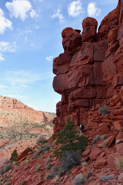
We passed a small cliffband on its east and stood at the base of the cliffs at 1.8 miles, 5,580 feet. The armoring encompassing Calico Peak is composed of two different sandstones. The lower unit is Moenave Formation from the Lower Jurassic era. It is reddish orange, fine-grained, and forms massive planar vertical sandstone beds, 200-300 feet thick. Watch for ripple marks.

Hug the wall while walking northwest and then north. The walking platform is not super generous but it's not terribly exposed. It goes without saying, watch your footing on unstable rock.
Grateful for the track we downloaded, we passed the first tempting weakness. Trip reports suggest there are alternative routes, Class 3 and higher. I have seen countless bleached, iron reduction spots in red beds but never one three inches across. We passed this disk about three minutes before coming to the weakness in the cliffs we were seeking.

At 2.1 miles we arrived at the promised break in the Moenave Formation. This marks the beginning of the best part of the hike--the climb to the summit ridge and walking along the top of the butte.

It was great fun, gaining a few feet, then weaving to and fro while seeking a way to achieve a few more. Keep track of yourself for the return trip.

There were sporadic cairns. We supplemented the instructive ones on our return. At 5,700 feet we did a lateral to the south and passed between this juniper and the wall.

On this route it is imperative to locate and pass through a thin crack between massive boulders, shown.
(THW, photo)

This image looks back at the crack. (THW, photo)

We topped out on the roof of the butte at 5,820 feet. Welcome to the Kayenta Formation. The Kayenta fractures horizontally forming ledges and welcoming walking platforms. It can be up to 330 feet thick but here it simply caps the top of the butte. (THW, photo)

The Kayenta comes in shades of tans and pinks and even white. The stone on the butte has weathered into whimsical shapes.

We walked out to the north end of the butte to watch the Paria River flowing to the southeast constrained by the prismatic pigments of the Chinle Formation. Powell Point is on the horizon in the center of this image and the Kaiparowits Plateau is center-right.

Bearing south to reach the highpoint we walked on the flat tops of weathered pink boulders.

What I thought was the obvious summit turned out to be an imposter. Keep going!

Calico Peak has an impossibly sweet finish.

The summit block is a couple of massive boulders resting against each other. (THW, photo)

We stood on the airy but comfortable highpoint at 2.6 miles. The smooth wire draped all about is the remnant of a survey tripod. Between the isolation and a rise of 502 feet, the views are phenomenal. (THW, photo)

In the west are the tippy tops of several Navajo Sandstone features. Starting on the left is the southern set of "White Teepees" followed by flat-topped Peak 6,780'. The northern set of White Teepees (Point 6,604' on Pilot Ridge) is barely visible. And finally, Mollies Nipple has a dark, iron-rich summit.

To the southeast the Paria River is about to pierce The Cockscomb. The Paria Township is across the river and due east of the symmetrical hill. Navajo Mountain is the massive dome on the horizon, image-center.

I'll conclude with a few informative photos. This study in the color red is the unnumbered point immediately east of the Paria Movie Set Day Use Site. The photo was shot from our camp off BLM 584. There was no traffic on the road, with the exception of a cowboy moving a small herd of cattle.

From the historic cemetery the summit of Calico Peak is ever present. (THW, photo)

The Historical Marker on US 89 displays the ripple marks typical in Moenave Formation. The view of Mollies Nipple is more comprehensive than it was from the peak. (THW, photo)

For students of history, here's a closeup of the Pahreah Historical Marker. (THW, photo)

2 comments:
Interesting. We were in the area last fall, and after meandering through the Paria Box and back, we wandered up a little ways below the "frontside" of Calico Butte. Might have to return now. The effort that you put into reports is much appreciated!
Steve, I love getting your immediate feedback on Calico. Next time, you'll have to wander around to the "backside!" As for Earthline, the joy I receive by reliving a hike as I write makes the task an "effortless effort." Debra
Post a Comment