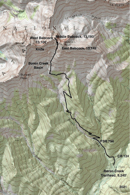
Essence: The three, steeply-pitched Babcock peaks are separated by deep, impassible crevices. Although they are tightly packed, each presents wildly different challenges for the climber. Middle Babcock, the tallest of the three and only ranked summit, is accessed from Boren Basin. Begin on a lengthy, cobbly track. Pitch up a rubble slope into the confines of a couloir with large, unstable material. Alight on the tipping point between the Boren and Tomahawk basins. The approach over, finish with a Class 3+ fantastical scramble on good rock with serious exposure. This is a classic La Plata Mountains climb for experienced mountaineers in groups of two or three. 2023 Note: Based on new, more accurate measurement technology, LiDAR, the elevation of Middle Babcock has been reduced to 13,161 feet.
Travel: From the US 160/550 intersection in Durango, travel 11.0 miles
west on US 160 to Hesperus. Turn right on La Plata Canyon Road,
CR 124, and measure distance from there. After passing the hamlet of Mayday the road turns to smooth dirt at 4.6 miles. There are several
established campgrounds in this area. Park in a pullout on the right at
8.1 miles, just past Boren Creek and about 200 feet before FSR 794.
Distance and Elevation Gain: 7.3 miles, 3,950 feet of climbing
Total Time: 5:30 to 8:00
Difficulty: Jeep track, off-trail; navigation challenging; Class 3+; serious exposure; steep, unstable slopes; helmets recommended
Map: La Plata, Colorado 7.5' USGS Quad
Latest Date Hiked: August 30, 2021
Quote: So, if you cannot understand that there is something in man which responds to the challenge of this mountain and goes out to meet it, that the struggle is the struggle of life itself upward and forever upward, then you won’t see why we go. What we get from this adventure is just sheer joy. And joy is, after all, the end of life. We do not live to eat and make money. George Leigh Mallory
There is an impassible gap between East Babcock (where the photographer is standing), and Middle Babcock. Shown, is the climber's ridge to Middle's zenith. Beyond, is West Babcock, the Knife, and Spiller Peak.
(Thomas Holt Ward, photo)
Route: Hike northwest up the Boren Creek Road into the basin. Leave the road and climb north into the couloir between Middle and East Babcock peaks. Scramble up the southeast ridge to the summit.
The route to Middle Babcock leaves the Boren Creek Road at 2.8 miles, 11,300 feet. The peaks on the high-angle north wall of the basin run in quick succession. Pause and take a moment to get clear about what you are looking at and to locate the proper route. Looking at the image below, on the far left is the crux of the Knife at the “tooth,” the south wall of the Knife, West Babcock with the smooth stone swale (image-center), Middle Babcock, the climbing couloir, “4th Crest,” and East Babcock. To further confuse the matter, the La Plata quad labels East Babcock as Babcock Peak, 13,149’. And yet, Middle Babcock is the highest of the trio at 13,180 feet.
The off-trail segment mounts 1,880 feet in less than 0.9 mile. To get started, hike north through the krummholz staying on the turf as best you can. The initial climb is arduous and eventually tedious on a combination of grass, scree, talus, and boulders. At 12,000 feet, the pitch steepens and talus rolls out from underfoot.
Note of Caution: We once witnessed two, three-foot cubes of stone cut loose from a Babcock couloir and, gathering more boulders, bounce-fly at 100 mph down the center of the basin where we had been moments prior. They skidded to a halt just shy of the jeep track. It was a narrow and lucky miss. Please be fully aware that your presence in the basin is potentially dangerous.
Several couloirs pierce the north wall. As a sanity check, the one you want is pictured below with an open sky "V" at its head. Middle Babcock is directly to its left and 4th Crest is to the right. (THW, photo)
Boulders in the chute are abraded and easily activated. Climb in lock-step. The west wall has better grip than the east; make use of its secure holds.
The passageway curves left and keeps on going.
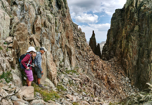
The couloir ends at 12,900 feet, 3.5 miles, in a cleft between 4th Crest and the southeast ridge of Middle Babcock. The cliff-framed vista restricts the field of vision to a slim, solitary tower and a narrow gash plummeting into Tomahawk Basin.
The summit is 0.15 mile afar. For experienced scramblers, the journey from here is pure pleasure. However, hikers with a fear of heights should turn back now. To access the southeast ridge of Middle, pitch up the ramp a few feet southwest of the tipping point. (THW, photo)
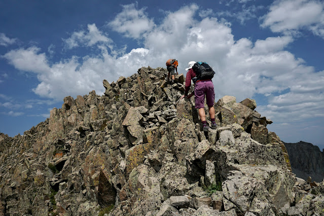
The southeast ridge hurtles down and terminates in the cleft. The corresponding Class 3+ terrain is steepest for 120 feet above the ramp. Most holds are good and solid but test them all the way to the summit. The route is not cairned; make mental notes of your approach so you don't overshoot the ramp on the downclimb. (THW, photo)
The grade softens and the razorback constricts. As always, stay right on the ridgecrest unless forced off momentarily. (THW, photo)
These scramblers are approaching the crux which initiates at two stone pillars. The Middle Babcock summit is pictured on the right and West Babcock is on the left. And yes, there is an impassible crevice between them. (THW, photo)
I have climbed Middle four times and have tried different tactics at the crux. I always hug my way around the pillars, shown. Then, once I stayed right on the spine and the three other times I was slightly off-ridge on the north. Friends have stepped down to the south before the pillars for a longer bypass. All choices are seriously exposed and some would argue a move or two is Class 4. Return to the ridgetop at first opportunity.
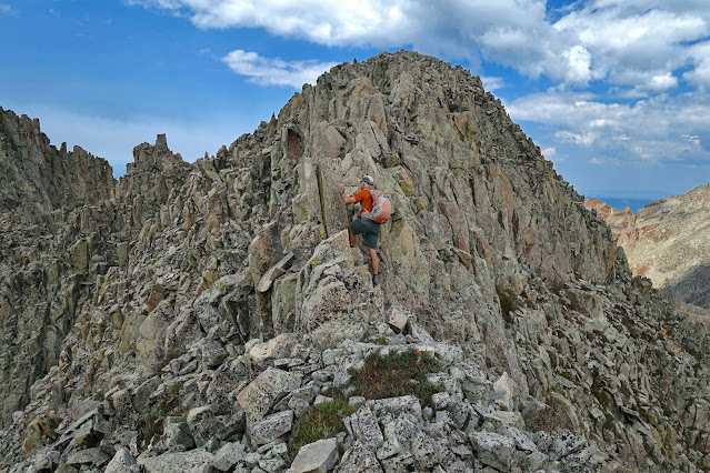
This image looks east to East Babcock Peak (roughly 0.1 mile away), Silver Mountain across La Plata Canyon, and a climber polishing off the best part of the adventure to Middle Babcock Peak. Arrive on the narrow, compact crest at 3.65 miles.
The five ranked La Plata thirteeners are all tucked into the northern tier of the West Block. They include banded Hesperus Mountain, the three towers of Lavender Peak, and the northwest cornerstone of Tomahawk Basin, Mount Moss. It goes without saying, Middle Babcock is in the brotherhood of wild heights, as well as Centennial Peak.
West Babcock is but a stone's throw away across a fearsome gap. Spiller Peak is at the west end of this east-west ridgeline dominated by the Babcock peaks. (THW, photo)
The downclimb from the peak to the road typically takes as much time and effort as the ascent. These hikers are working down the southeast nose aiming for the ramp. (THW, photo)
This image depicts the top of the couloir, the intimate balance point between two major basins in the La Plata Mountains. The hikers are contemplating the unavoidable slick slide down the ramp and into the couloir. (THW, photo)
Hold your concentration in spite of any physical fatigue or mental monotony. Discombobulated boulders slide at the slightest touch. If the weather holds, be sure to visit the obvious orange outcrop a good way down toward the road. Walk out the top line of stone and balance on the
miniature pedestal. Watch for eagles and peregrine falcons in the upper
basin.


6 comments:
Thanks for all the great beta on the La Platas, I have been using it all summer. I stood on Middle today and really question whether its 80 feet higher than West. What is the basis for 13,180 feet for Middle and 13,100 feet for West?
Hi Brian, Middle in November! Delighted for you. Middle was at the top of my list for a repeat this year but I had hand surgery in July--no scrambling. It is generally accepted that the La Plata quad is inaccurate for the Babcocks and that Middle is the tallest at 13,180'. Lists of John agrees. However, I made the standard height approximation for West by looking at the topo so 13,100' is not definitive. I was on West early this summer and from there Middle looks higher. I'm delighted Earthline was useful for you. Debra
Thanks for the prompt reply Debra. I certainly agree that USGS quads have errors/mistakes, e.g. in my beloved Idaho Sawtooths some spires are completely missing from the topos. Being a mountain nerd like yourself, I am only looking for clarity and after researching LoJ and USGS, still come up empty as how Middle Babcock got assigned an elevation of 13,180 feet. As for West vs. Middle, guess I need to climb West now😊. Being a list nerd too, I put together a La Platas list on peakbagger.com. Hope to see you in the La Platas next year!
This is Northwest Babcock described here. Babcock has four summits. Middle is the lowest of the four and sits between the East and Northwest summits
Rowan, Oops! I deleted your duplicate comment and it took out all the replies. I didn't mean to do that. I wanted to leave your observations on this post. In any case, congratulations on your gnarly Babcock traverse. Regarding the names, unnamed peaks are generally referred to by convention. The names I use here were introduced to me by members of the Colorado Mountain Club (CMC) over 20 years ago. They still use this naming convention today, as evidenced by "The Knife" entry in "Colorado Scrambles" (CMC Press).
Here is Rowan's comment that I deleted by mistake dated 9/9/21: The people who actually climb the lowest prominence generally accept the designation of Middle Babcock to this summit. It is also probably the most technical and enjoyable climb and certainly deserves its recognition as one of the four Babcock summits. Climbing Babcock is definitely a four peak traverse, not three. Obviously there’s no official map distinguishing much correctly in the western LPs or naming the separate Babcock summits, but it is also simply more accurate to distinguish the highest summit as Northwest and the lowest as middle in terms of each summit’s location relative to the entire mountain/ridge.
Post a Comment