Essence: Climb two ranked summits and one point located on the western front of the Santa Catalina Mountains. Begin in Catalina State Park on the popular Romero Canyon Trail. Step off-trail and the wilderness experience is immersive--no cairns, no social trails, no footsteps. The spurs to the peaks are charming, short, fun scrambles. The trek to Point 4,868' is lengthier and complicated by obstacles. It finishes with a Class 3 wall. Do all three or pick and choose. Peak elevations stated in the title of this post and in the text reflect the Oro Valley and Mount Lemmon topographical maps. However, LiDAR has increased the elevation of Peak 3,932' to 3,945 feet with a rise of 332 feet. Peak 3,935' is now measured at 3,949 feet with a prominence of 308 feet. The hike begins in Catalina State Park and transitions into the Pusch Ridge
Wilderness managed by the Coronado National Forest.
Travel: The park is located at 11570 North Oracle Road, Arizona State Route 77, in the city of Oro Valley north of Tucson. From the entrance station drive 1.5 miles and park in a large lot on the left at the end of the paved road. Vault toilets, water.
Distance and Elevation Gain: 9.9 miles; 3,150 feet
Total Time: 7:30 to 9:00
Difficulty: Trail, off-trail; navigation moderate; Class 3 with mild exposure; brushy, wear long pants; carry more water than you think you will need; hike in winter months to avoid scorching temperatures and rattlesnakes.
Maps: Oro Valley; Mount Lemmon, AZ 7.5' USGS Quads
Dates Hiked: December 2, 2023 and December 15, 2023
Catalina State Park: Visit the website for information on fees, hours and campground.
Reference: A Guide to the Geology of Catalina State Park and the Western Santa Catalina Mountains, by John V. Bezy, Arizona Geological Survey, Down-to-Earth No. 12, 2002.
Pusch Ridge Wilderness Bighorn Sheep Closure: It
is prohibited to
travel more than 400 feet off designated Forest Service trails from
January 1 through April 30, bighorn sheep lambing season. All three prominences are off-limits during that period. Dogs are allowed in the park
on leash but not in the wilderness.
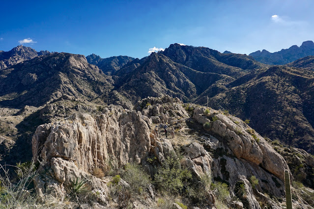
Quote: To many of us, the wilderness truly unaltered by human interference, the wilderness with its wealth of life rolling across it in great surges, ebbing and flowing with the seasons of the years, is inseparable from our innermost beings. Ian McTaggart-CowanPeaks 3,935' and 3,932', seen below from the ascent to Point 4,868', are but minutes away from the Romero Canyon Trail. And yet, all three climbs are Pusch Ridge wild and top out on weathered stone summit blocks.

Route: From Catalina State Park hike east on the Romero Canyon Trail. The three prominences are presented as optional spurs off the corridor trail. Climb as many as you wish. Note: On
December 2, 2023, we climbed Peak 3,932' and Point 4,868' with the
Southern Arizona Hiking Club. We are grateful for their guidance and companionship. On December 15, 2023, we returned independent of the group and tacked Peak
3,935' on to the end of a larger exploratory hike.

Established in 1982, Catalina State Park has an elaborate maze of
trails penetrating 5,500 acres renowned for a diverse bird and floral
population. From the north end of the parking lot cross the park road to
access the trailhead, elevation 2,717 feet. The mosaic mural at the
trailhead was commissioned by the Friends of Catalina State Park,
established in 2012. (Thomas Holt Ward, photo)


The alluring trail penetrates a mythical rock wilderness created by natural forces. Wilderness Suite Granite fractures vertically. Forces of erosion--ice expansion, wedging by plant roots, chemical decomposition--are coupled with weathering. Over time joints spread and become canyons, leaving blocks, domes, and pinnacles at skyline. The wedge image-center is Point 5,110', informally named "Frank's Dome."


Do a descending traverse on a natural ledge with mild exposure. Then turn straight uphill at the first opportunity.


The highpoint is a single, weather-rounded boulder with room for four people. My partner is looking at Peak 4,710', "Golder Dome," (LiDAR 4,730') near the terminus of Sutherland Ridge.


We busted out of the boulders onto an open slope at about 3,960 feet. (THW, photo)

Upon contacting the west ridge proper our group split up. Most hikers tracked below the ridge, shown, and my partner traversed on top. Getting on the ridgecrest can be sketchy and troubled so wait until you find a comfortable access point. (THW, photo)

This image was taken from the ridgetop where our group reassembled. The forthcoming knob, shown, posed some terrain challenges.


This massive balanced rock is attached to its base by a scant ribbon of stone.

Below, hikers are approaching the summit block. The only access point is through a hole made by two giant boulders leaning on each other. It is located on the south side of the block a third to half way up from the base.


There is only one path to the summit. It is so delightful it might well be the primary reason to mount this unranked point. The Class 3 wall has good footholds on quartz veins and pegmatite clusters. (THW, photo)

For the descent, we went back through the hole and then did an 800-foot dive south to the Romero Canyon Trail. We intersected the trail about 1.4 miles east of the pools. While there were no serious obstacles it was tedious and slow picking our way downslope. Feel free to try something else--return as you came, or bear southeast on a shallow descent to the trail. (We have not tested this option.) While this will add significantly more distance, it looks good on the map. The image below shoots back up at our descent route from the Romero Canyon Trail.
In the afternoon the desert is still and warm, shadows are long, and on the Romero Canyon Trail you get to walk through walls.

Six trails leave from this location. Follow signage for the Romero Canyon
Trail.

Cross Sutherland Wash roughly a mile upstream of its confluence with
Cañada del Oro. Nearing the conclusion of its journey the slow-moving
stream consumes a broad flood plain. While this is likely to be a
hop-across, it can be a boots-off ford. After an alarmingly dry summer and fall in 2023 the vital waterway was stone dry. Below, the north face of Table Mountain looks formidable and Table Tooth to it's left is visually deceptive. It appears as a thick wedge from this perspective but it is a four-foot-wide slice of stone.

Turn left uphill on an old road. It swings east advancing into the foothills of the Santa Catalina Mountains. The alluvial fan to the south is composed of blocks of granite and gneiss that fell from the ramparts above. The huge boulders were rafted to their present location by debris flows. The stone monuments that the park is renowned for are composed of Wilderness Suite Granite. Injected deep within the Earth’s crust as great molten masses, the rock cooled and solidified over millions of years and
miles below the Earth’s surface. The pluton was emplaced 45-50 million years ago. (See Bezy sited above for much more information on regional geology.)
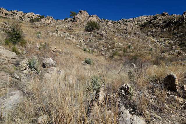
The Canyon Loop Trail branches left at 0.6 mile. Stay straight and cross a flat covered in golden grasses, saguaro, paloverde, pricklypear, barrel cactus, ocotillo, and mesquite.

There are two hand stenciled acetylene torch signs declaring that dogs are not allowed in the Bighorn Sheep Management Area. The first is half a mile before the wilderness boundary. These signs are so unusual and so masterfully rendered I'm including photos of both.


At 0.9 mile a spur trail veers right into Montrose Canyon and Pools. The Romero Canyon Trail begins ascending the divide between Montrose and Romero canyons on railroad tie steps. The linear summit ridge of Peak 3,932' is already visible, image-left.

Enter the Pusch
Ridge Wilderness at 1.2 miles.

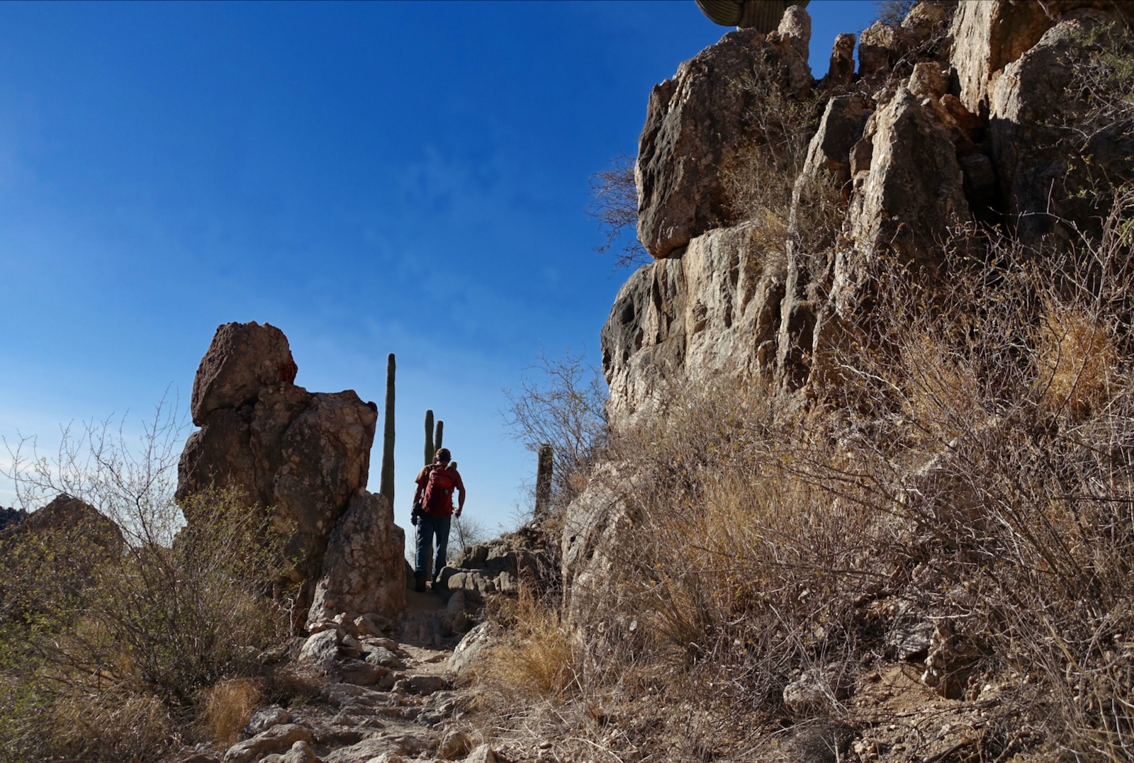
The passageway between the wilderness boundary and Romero Pools is one of my favorite trails in the range. It's never steep like the principal footpaths on the Catalina Front (Pima, Finger Rock, Ventana, Esperero...). It follows the dictates of the landscape, a stone passageway on glistening crystalline bedrock. It mounts boulder stairways, squeezes through slots, and is cleaved into sidewalls. Construction was done with a light touch and it feels perfectly natural. (THW, photo)

The alluring trail penetrates a mythical rock wilderness created by natural forces. Wilderness Suite Granite fractures vertically. Forces of erosion--ice expansion, wedging by plant roots, chemical decomposition--are coupled with weathering. Over time joints spread and become canyons, leaving blocks, domes, and pinnacles at skyline. The wedge image-center is Point 5,110', informally named "Frank's Dome."

Peak 3,932'
Gain the divide at a small saddle at 2.0 miles, 3,640 feet. This first friendly looking peak is my favorite of the three. It's handy, requires some navigation savvy, throws up minor challenges, and has a great viewpoint and fascinating rock. Roundtrip is 0.8 mile with 320 feet of vertical, and takes 1:00 to 1:15. I would gladly return to climb this “itty
bitty bad boy” time and again. To begin, mount north up the broad south ridge to the false summit, shown. The ground is littered with fallen ocotillo and there are saguaros and cholla to dodge.

This image was taken from the false summit. Most of the elevation gain is behind you but the linear summit ridge mentioned earlier is not exactly straight-forward. Now the real fun begins.

Check out the bedrock under your feet, a mix of big chunks of embedded quartz and thin bands of darker rock.
The stone has been roughed up by weathering in such an unusual manner.

Below, hikers are finagling a path through a maze of ridgetop boulders. It is a wild route within a confounding and thrilling wilderness. (THW, photo)


We were not able to find a nontechnical pitch straight up the summit block, pictured. But there was, thankfully, a sneak-around on the west
side of the peak.

This image was taken from the summit looking back at hikers poised to begin the bypass. (THW, photo)

Do a descending traverse on a natural ledge with mild exposure. Then turn straight uphill at the first opportunity.

The climb finishes with a friction pitch with sticky features. Below, Cathedral Rock is the most audacious granite dome in the vicinity. (THW, photo)

The summit is roomy and features views of all things indescribable in the Santa Catalina Mountains and the rest of the world westward. Simply retrace your steps to Romero Canyon Trail. (THW, photo)

Peak 3,935'


Heading east from the spur to Peak 3,932' the trail goes briefly downhill and then climbs again while flanking the
west face of Peak 3,935'. The route to the peak begins just
before the footpath reaches its highest point on the divide overlooking the cascades of lower Romero Canyon. The little mountain is located south of the trail. The launch is 2.4 miles from the trailhead or 0.4 mile past the spur to Peak 3,932'.
This is possibly the quickest jaunt to a ranked summit in the range. Roundtrip is 0.25 mile with 200 feet of vertical. It took us 12 minutes, trail to summit. The image below was taken at the departure from the trail. The route goes up the ridge image-center.

Begin by skirting the first monolithic boulder on the left. Scramble back to the ridgetop. The moves are Class 2+ on good rock with no exposure. (THW, photo)

It is a delightful, obstacle-free scramble to the crest image-right. (THW, photo)

The highpoint is a single, weather-rounded boulder with room for four people. My partner is looking at Peak 4,710', "Golder Dome," (LiDAR 4,730') near the terminus of Sutherland Ridge.

Peak 3,932' is four feet lower. This is a nice angle on the complexity of the summit ridge.

Return to the trail as you came. We descended on the northwest ridge to the trail. It was ultra brushy, steep, with invisible holes in tall grass. Avoid it. For those completing the triumvirate, Point 4,868' can be seen from the summit of Peak 3,935'. The crest is below the horizon and therefore difficult to visually peg.

Point
4,868'
For those going on to Point 4,868', continue east on the trail as it descends to the Romero Pools at 2.9 miles, 3,680 feet. Water-scoured slides, cascades, and deep tanks in polished granite
extend both up and downstream. The trail crosses Romero Canyon at the pools. Remain on it for another 0.1 mile. The prominence is 1.3 miles to the northeast with 1,200 feet of vertical. There are three or more alternate return routes. Our loop was 2.8 miles. (THW, photo)

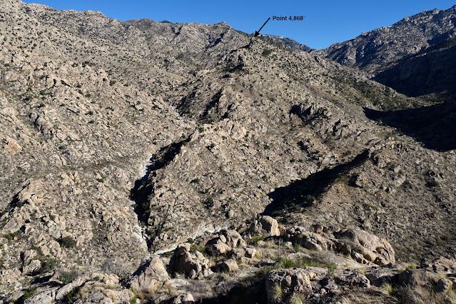
Start by crossing a flat on the canyon floor and contact the southwest ridge of Point 4,868'. The ridge points northeast for the first 0.6 mile and then curves due east to the summit. The route is rather complicated from here clear to the crest. The first goal is to get up and over a large stone knob. The ridge is restricted enough that choices are limited. It might be possible to flank the knob on the northwest but the series of playful, low Class 3 moves up cracks and over boulders are great fun. Plus, it's always good form to stay on the ridge unless forced off.

We busted out of the boulders onto an open slope at about 3,960 feet. (THW, photo)

Upon contacting the west ridge proper our group split up. Most hikers tracked below the ridge, shown, and my partner traversed on top. Getting on the ridgecrest can be sketchy and troubled so wait until you find a comfortable access point. (THW, photo)

This image was taken from the ridgetop where our group reassembled. The forthcoming knob, shown, posed some terrain challenges.

It was a little tricky on this friction pitch.

This massive balanced rock is attached to its base by a scant ribbon of stone.

Below, hikers are approaching the summit block. The only access point is through a hole made by two giant boulders leaning on each other. It is located on the south side of the block a third to half way up from the base.

Once through the hole, scramble up boulders and bedrock to the ridgetop.

There is only one path to the summit. It is so delightful it might well be the primary reason to mount this unranked point. The Class 3 wall has good footholds on quartz veins and pegmatite clusters. (THW, photo)
The summit dome is constricted but we managed to squeeze the entire SAHC group on top to sign the peak register. Notably, there were a few rainwater-filled gnammas, or solution pans, on the relatively level granite surface. Needless to say, this little point is a thrilling overlook. (THW, photo)

For the descent, we went back through the hole and then did an 800-foot dive south to the Romero Canyon Trail. We intersected the trail about 1.4 miles east of the pools. While there were no serious obstacles it was tedious and slow picking our way downslope. Feel free to try something else--return as you came, or bear southeast on a shallow descent to the trail. (We have not tested this option.) While this will add significantly more distance, it looks good on the map. The image below shoots back up at our descent route from the Romero Canyon Trail.

Be sure to check out the backside of the trailhead mosaic by "More Friends of Catalina State Park." (THW, photo)

Just for fun...don't try this! It's a playful photo trick courtesy of my partner, Thomas Holt Ward.

No comments:
Post a Comment