Essence: The Dragoon Mountains are a 25-mile-long range trending northwest-southeast. They are bordered on the east by the Sulphur Springs Valley and on the west by the San Pedro Valley. The mountains are named for the 3rd U.S. Cavalry Dragoons, mounted infantry armed with short musket dragoons (mid-1800s). Sheepshead is the most prominent and aesthetic dome in the western Dragoons. For the technical climber there are over 40 multi-pitch routes up the fabled 650-foot granite wall. For the hiker, the base of the summit dome is achievable via a Class 2+ trail. Approach over, cairns guide up a charmed route for a low Class 3 finish with essentially no exposure. With a rise of 285 feet, Sheepshead is not a ranked peak. However, the expansive and sublime summit dome is unparalleled in Arizona. This is a half-day hike. Extend your day by climbing one or two other prominences on your return to the trailhead. The hike is within the Coronado National Forest.
Travel: Exit I-10 in Benson and drive south on AZ 80 toward Tombstone. Roll through Saint David. Just before mile marker 314, AZ 82 splits to the right toward Nogales. Stay on AZ 80 toward Douglas and Tombstone. Go up a rise and at the top of the hill, just past mile marker 315 (The post is on the east side of the highway.) turn left/east on Middlemarch Road. This is about 22 miles south of Benson and two miles north of Tombstone. Measure distance from the turnoff. Pavement ends at one mile. The wide graded road passes scattered residences. Drive over cattle guards and cross shallow washes. There is a clear view of Sheepshead. At 9.6 miles, at a cattle guard turn left on FSR 687 and enter the Coronado National Forest. Our odometer tends to be a little conservative. Remeasure from there. The road narrows. Turn right on FSR 4806 at 0.3 mile. It may not be signed. Pass a windmill at Tenneco Well with three water tanks. (On the Haberstock Hill topo.) At 0.7 mile, the road splits. Go left to generous parking at the trailhead in front of a green gate, or right for camping with a community of climbers. No facilities, no water.
Distance and Elevation Gain: 3.6 miles; 1,450 feet. Add two prominences for a total of 4.1, 1,800 feet.
Total Time: 3:15 to 4:00; the two points add less than one hour.
Difficulty: Trail; navigation moderate; low Class 3 with mild exposure; hike during winter months and carry all the water you will need.
Maps: Haberstock Hill; Black Diamond Peak, AZ 7.5' USGS Quads
Date Hiked: December 25, 2023
Poem:
I cannot tell you
How the light comes.
What I know
Is that it is more ancient
Than imagining.
That it travels
Across an astounding expanse
To reach us.
Jan Richardson
How the light comes.
What I know
Is that it is more ancient
Than imagining.
That it travels
Across an astounding expanse
To reach us.
Jan Richardson
The chill light of dawn awakens Sheepshead on Christmas Day. (Thomas Holt Ward, photo)
Route: Bear north-northeast on-trail to the base of Sheepshead. Ascend through a break in the escarpment to a saddle on the ridgeline. Climb the north face of the dome to the crown. Mount points 5,441' and 5,437' on the return if you wish. Note: The Haberstock Hill quad has 20-foot contour intervals and Black Diamond Peak has 40-foot intervals.
The Dragoons are a two hour drive from our home in Tucson. When we arrived on Christmas morning, it was a frosty 30 degrees and climbers in a dozen vans were just beginning to stir. Open and close the trailhead gate, elevation 5,140 feet. (THW, photo)
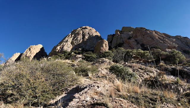
The trail penetrates a mesquite bosque residing in a vast field of pale straw. Horizontal light plays among unspeakably beautiful sculpted and weathered granite features--boulders, domes, pillars, and walls. The early morning earth is still. It is wondrous to walk among the rock beings.
The Late Cretaceous to Early Tertiary rock was emplaced during the Laramide Orogeny (70 to 55 million years ago), a time of mountain building in western North America. The equigranular intrusive igneous rock is composed of medium-grained granodiorite.
The trail arcs to the northeast between unranked points 5,441' and 5,437'. The footpath was engineered with wood and stone steps presumably some time ago given the trenching of the track. Vegetation diversifies with Arizona oak, beargrass, sotol, yucca, and manzanita. The trail skirts to the southeast of a disorganized ridge topped with globular nubbins. (THW, photo)
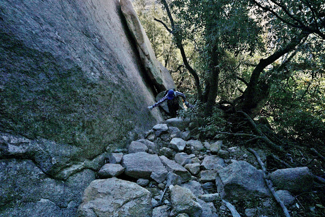
Cross the Sheepshead drainageway at 0.75 mile. On our frigid hike the foliage was dripping with glistening icicles. At one mile the trail swings into the draw to the west of Sheepshead. The image below was shot on our return to capture mid-day lighting. The trail works up through boulders exfoliated from the monolith, brushes up against the wall, and then mounts the treed chute, just as you no doubt suspected. The final pitch to the summit is around the back and out of sight.
The climb begins on stone step-ups. The shaded forest wafts piñon. Open and close the barbed wire gate. We were tempted to play around on the discombobulated ridge to the west. (THW, photo)
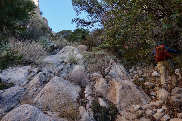
The trail is a mix of dirt, boulders, and bedrock. Watch for cairns on stone surfaces. Be aware that they sometimes lead off-route to climbing pitches. Ocotillo, resurrection moss, agave, and rainbow mammillaria enhance the stony terrain. This photo was shot on our return. (THW, photo)
Trail builders didn't use explosives. They just found natural pathways on and through the granite. The track wiggles all around. It's very cool. (THW, photo)
We didn't see climbers on our way up the mountain but on our return we passed below groups all over the big wall. (THW, photo)
Reach out and touch a madrone tree so ancient it surely witnessed Chief Cochise hiding out from his pursuers before surrendering at nearby Council Rocks in 1872. (THW, photo)
The Too Tough To Die is a 5.10, six-pitch route. The name references gunslinger Wyatt Earp and Tombstone, the town too tough to die.
At 1.4 miles, 5,920 feet, turn up into the chute between the cliff walls. The path is braided. Search for it if you lose it. When in doubt, don't follow lateral paths, rather, keep it pointed uphill. Footing is good, rock is solid, vegetation is heavy but not hindering.
Near the top of the break, the wall on the left has a streak of lime-green lichen on a seep path. It's hard to see in this image (This was a Winter Solstice hike; shadows linger long.) but to its left, a monster boulder is clinging with all its might to the parent rock. What's holding it there defying the law of gravity? After all, gravity never sleeps.
Gain the top of the chute at 1.6 miles, 6,260 feet. I felt the comforting sensation of being embraced by granite, walls swooping down. Were it not for the break, hikers wouldn't be able to summit Sheepshead and I was grateful. This image was taken on our return and the suspended boulder is visible image-right. (THW, photo)
At first glance the route to the peak looks impossible from the saddle but it reveals itself as you go. I have a deep fondness for routes that look unlikely--it feels magical as they dash up one crack and wander over to another. The scrambling never exceeds low Class 3. Holds are solid, exposure is minimal. To get started, back down the trail a few steps so you can move over next to the wall. Turn east briefly and then mount south on the north face of the dome. The route is well cairned. If you lose the rock piles,
relocate. (THW, photo)
Go up a thin chute with well seated stones. There was a big reassurance cairn at the top of the slot.
There is a short bit of trodden soil but mostly the route is on solid rock. (Makes my heart sing.)
Take baby steps up this short friction pitch. (Not as scary as it looks.)
There's a little Class 3 bouldering.
Emergence! As you crest, the surface of the granite dome is covered in waterpockets. It had rained recently turning the potholes into disks of ice. (THW, photo)
The route tops out on a subsidiary dome. We were completely blown away. Divine is not too strong a descriptor. Having grown up on granite in the Sierra Nevada Mountains I was on home rock. (THW, photo)
There's only one way to get there. Sticky soles help.
Arrive on Sheepshead at 1.8 miles. Below, I am floating across a dreamscape. (THW, photo)
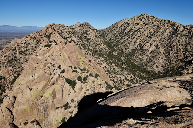
The surrounding landscape is complicated. This image looks north to Point 6,848'. The highest point in the Dragoon Mountains is Mount Glenn, 7,519 feet, a ways off in the north.
Northeast is Peak 6,977'. (THW, photo)
The trailhead and approach route is visible below. We decided on a whim to climb the two little bumps on the western fringe of the Dragoons (image-center). They are not terribly impressive but they afford nice views.
The Whetstone Mountains are due west across the San Pedro Valley. While achieving Apache Peak and its companion French Joe is arduous, treasures all along the way more than compensate.
It was easy to unwind from the crown back to the saddle. Most hikers will simply retrace steps to the trailhead. If you'd like to check out the little prominences, start with Point 5,441'. It is a small commitment and yields a stunning perspective on Sheepshead. It's just 0.15 mile and takes fewer than ten minutes to reach the top. Leave the trail at 3.0 miles and walk southwest across a grassy flat.
The climb is mellow and pleasant with negligible brush and stone steps. Boulders and bedrock are covered in thick blue lichen.
The crest is an unexpectedly narrow rocky ridge running north-south. Looking quite impressive to the southeast are Black Diamond Peak and Peak 7,155' with almost 1,300 feet of prominence. The Desert Mountaineer has a compelling and thorough description of the hike to both peaks. (THW, photo)
The virtue of Point 5,441' is its unparalleled perspective on Sheepshead.
For the second bump we left the trail at 3.3 miles, crossed a dry creek and stepped over a barbed wire fence. We were lacerated by thorny plants near the drainage but it was a nice climb once we were clear of the waterway. This image looks back on Point 5,441'.
We were adjacent to the west face of the ridge we scooted around earlier on our way to Sheepshead.
We angled southeast off the crest back to the trail. While no serious obstacles stood in our way, the slope was thick with shindaggers.
We have climbed to the highest point in the Dragoon Mountains. We have explored on and off-trail in the Cochise Stronghold. We've entered mazeways only to be bounced back out by the impenetrable. We are enthralled with the weathered and spheroidal stone and look forward to turning our attention to the Council Rocks region.


.jpeg)


No comments:
Post a Comment