Essence: Point 4,625' forms the perpendicular sidewall at the northwest entrance to Finger Rock Canyon. Rock has exfoliated from the cliff façade leaving the image of a Thunderbird, the informal name for the unranked prominence. The escarpment features prominently when observed from Linda Vista and Pontatoc Ridge. The short but challenging hike is best suited for desert mountaineers well adapted to off-trail travel, nuanced navigation, thorny brush, and Class 3 scrambling. Familiarity with the Catalina Front is recommended. This hike is within the Pusch Ridge Wilderness, managed by the Coronado National Forest.
Travel: From Tucson's Skyline Drive, go north one mile on Alvernon Way to the Richard McKee Finger Rock Trailhead. Park in a large lot on the left. There is a drinking faucet but no other facilities.
Distance and Elevation Gain: 4.4 miles; 1,700 feet
Travel: From Tucson's Skyline Drive, go north one mile on Alvernon Way to the Richard McKee Finger Rock Trailhead. Park in a large lot on the left. There is a drinking faucet but no other facilities.
Distance and Elevation Gain: 4.4 miles; 1,700 feet
Total Time: 4:00 to 5:00
Difficulty: Trail, off-trail; navigation challenging; Class 3; mild exposure; wear long pants; carry all the water you will need; hike in winter months to avoid scorching temperatures and rattlesnakes.
Map: Tucson North, AZ 7.5' USGS Quad
Dates Hiked: December 18 and December 27, 2023
Difficulty: Trail, off-trail; navigation challenging; Class 3; mild exposure; wear long pants; carry all the water you will need; hike in winter months to avoid scorching temperatures and rattlesnakes.
Map: Tucson North, AZ 7.5' USGS Quad
Dates Hiked: December 18 and December 27, 2023
Pusch Ridge Wilderness Bighorn Sheep Closure: It is prohibited to
travel more than 400 feet off designated Forest Service trails from
January 1 through April 30, bighorn sheep lambing season. Thunderbird is off-limits during that time period. No dogs!
Quote: I belong in this canyon. I am truly a part of it. If I miss a week, I miss it. It's good old human curiosity. There's always something different. It's absolutely amazing. David Bertelsen
Quote: I belong in this canyon. I am truly a part of it. If I miss a week, I miss it. It's good old human curiosity. There's always something different. It's absolutely amazing. David Bertelsen
Solstice dawnlight illuminates Thunderbird (image-center) and its higher brethren, Prominent Point, Finger Rock and Finder Rock Guard. Mount Kimball is the tree-covered bastion at the head of the canyon.

Route: Hike north and northeast on the Finger Rock Trail. When the trail begins climbing out of the canyon on the southeast wall, leave the footpath and scramble up Finger Rock Canyon. Divert northwest into a side canyon at 3,700 feet. Go left when the canyon splits two more times. Leave the drainage at 4,300 feet and climb southwest to a small interior eastward ridge. Ascend to the north ridge of Thunderbird. Scramble to the summit. To return, the sure bet is to retrace your steps. The southwest ridge is delightful but impeded by private land at the wilderness boundary. I don't recommend either the red-line or blue-line routes back to the Finger Rock Trail.

Having seen Thunderbird time and again from Linda Vista I've long considered it to be the entrance gate to some of the most wondrous features in the Pusch Ridge Wilderness. I contemplated approaching it from the lower end on the southwest ridge. Thank you Mike and Gregg for the suggestion to come at it from the north ridge and for crediting the name "Thunderbird" to field botanist David Bertelsen. (THW, photo)

Finger Rock Trailhead, elevation 3,060
feet, is one block up Alvernon Way from the parking lot. Our quest was visible even before we hit the trail.

At
0.1 mile the Pontatoc Trail branches off to
the right. Stay on Finger Rock Trail No. 42 and enter the Pusch Ridge Wilderness. Now plants are free to be themselves and they exemplify the Sonoran
Desert at its finest.

Cross the wash in Finger Rock Canyon at 0.9 mile. For a few steps the world goes gray and white. The stone is a mix of Catalina Granite and Catalina Gneiss. While there was no water flowing in December of 2023, the watercourse is capable of carrying torrents. In 2021, the streamway was expanded, denuded, and blown out by monsoonal floods.

The Finger Rock Trail starts climbing the southeast wall at 1.2 miles. Step over a row of rocks designed to keep the general public on track and make your way into the channel.

There is a superb view of Thunderbird from this location. This post is dedicated to David Bertelsen who has done infinitely more than bestowing Point 4,625' with its beguiling and fitting name. Bertelsen hiked the Finger Rock Trail to the top of Mount Kimball 1,627 times between 1981 and 2017, and he's still making laps. He has documented numerous observations of 615 species of flowering plants (and counting). His work is remarkable because of the span of time it covers, the number of species recorded, and the significant elevation range of his observations. His longitudinal study serves as an important record of how plant communities in this portion of the Santa Catalina Mountains have changed over four decades. (Bertelsen, C. David, "Thirty-Seven Years on a Mountain Trail," Desert Plants, vol. 34, nos. 1 and 2, 2018, Boyce Thompson Arboretum, Superior, AZ)
(Thomas Holt Ward, composite photo)


We couldn't find any evidence of Finger Rock Spring as we flew up the rough and tumble streamway.

Be on the lookout for the brown wall pictured below. The drainage splits just beyond it.

At 1.5 miles, 3,700 feet, cut left into a side canyon, image-left. This tributary of Finger Rock is obvious on the Tucson North quad.

Scamper up the boulders in the open channel. It is a pleasurable, big-step scramble. Everything checks out just fine on the ground but if you look up, all routes up and out of there look intimidating if not impossible.

Pass a stocky ancient coralbean growing right in the channel. Coralbean is rare in the United States. In Arizona it is native only to Pima and Santa Cruz counties. It prefers dry rocky slopes, washes, and canyons.

Coralbean has striking red tubular flowers. The fruit is a brown pod with toxic, showy, orange-red seeds. (THW, photo)

On our second hike (to find a better departure route from the southwest ridge) water had pooled. This canyon-bottom route would be troublesome if water was flowing. At 1.6 miles, 3,940 feet, a short wall spans the wash. There's a Class 3 move with great holds under the overhanging boulder on the right.

Bypass a pouroff and get back into the drainage. Continue upcanyon passing an amphitheater on the west, shown. The arc on the left is actually the east ridge of Thunderbird. Brush impairs as the wash pinches and steepens. (THW, photo)

At 1.8 miles, 4,040 feet, watch carefully for a split in the drainage, shown. Take the left branch. Catclaw and hackberry annoy--patience and tolerance are required. You might be better off on the hillside west of the wash.

At about 4,200 feet, go left once again at another very subtle split. I just assumed we'd continue on this trajectory to a saddle at the head of the canyon. But the ravine pinches down tight and even if you made it to the ridge, a gendarme blocks passage to Thunderbird. Therefore, at 1.85 miles,
4,300 feet, climb out of the drainage on the west. The first time we hiked this we fumbled around at other possible exit points but they all failed. This one works beautifully.

The bearing turns sharply from northwest to southwest. Footing is difficult at first beside a wall. There's not a
lot of wiggle room.

The steepness of the
hillside moderates. The goal is to alight on the small eastward ridge above the outcrop, image-left.

Gain the interior ridge at 1.95 miles, 4,440 feet. The outcrop is too tantalizing to deny.

From there it's a short, mellow climb west to the north ridge of Thunderbird.

Intersect the north ridge at 2.0 miles, 4,500 feet. This image looks down on the playful outcrop.

The Thunderbird summit is just 0.2 mile upridge. (THW, photo)

We wondered if this could be an alternate route to Prominent Point West (image-right) but discarded that idea. There appears to be a lot of interference, it's probably not a short cut, and the standard route is a guaranteed pleasure.

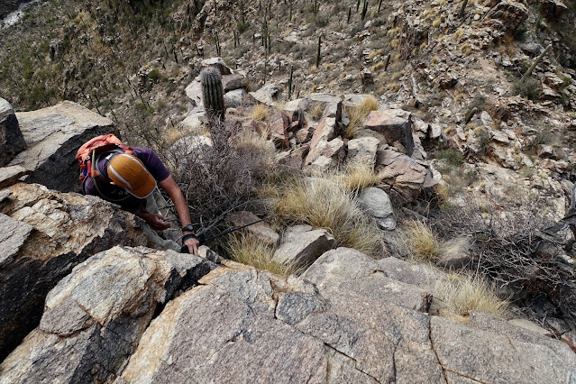
From the saddle we worked both sides of the ridge. Catclaw and other assorted thorny plants are vicious. Protect yourself. At the gendarme pictured, we went into the gap between two large boulders and then climbed up through the rocks on the east side. 

It is a light scramble with mild exposure. (THW, photo)


The summit ridge rounds off for a delightful finish. (THW, photo) 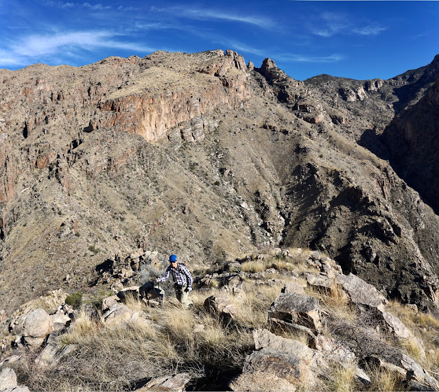
The crest is broad but the highpoint is just a small cluster of stones. 


Standing on the edge it's a 1,000-foot drop to the floor of Finger Rock Canyon. The Finger Rock Trail, a marvel of engineering, cuts across the opposing slope.


The vista stretching out from the home front is sweeping and spectacular. We wanted to see more of the mountain so we descended on the southwest ridge but it is advisable to return the way you came. We blissed out on the southwest side of the mountain, that is, until we left the ridge. Private land butts up against the wilderness boundary. If you have a connection on the other side you're golden. Otherwise, you have to cut back to the trail and I can't recommend either of our routes. (THW, photo)

Heading southwest along the cliff edge the grasses are trampled by game. We saw what must have been bighorn sheep tracks. (THW, photo)

The initial 400-foot mellow descent is as good as it gets in the Pusch Ridge Wilderness. Walk along the edge of the world on slabs of bedrock, weaving between boulders.

Arrive at the top of a 50-foot cliff at 4,280 feet. As shown below, the ridge cuts sharply down to a 4,220-foot saddle and then goes up and over a spicy roller. On our first hike we left the ridge at the saddle and made our way south to the Finger Rock Trail, the red-line route. We were so unhappy with that, on our second hike we went over the roller before cutting back to the trail, the blue-line route. That was a great improvement...until we left the ridgeline. (THW, photo)


As for negotiating the cliffband, there's not a lot of room to work with but we found an enjoyable Class 3 downclimb with solid holds and minimal exposure.

This image looks back up at the cliff. (THW, photo)

We were in the saddle at 2.4 miles. The reason I put the red-line route on the map above is to suggest you avoid this aggressive bushwhack. It will indeed get you back to the trail but it drops 860 feet in under half a mile. It's super steep, prickly plants include carnivorous catclaw, and footing is sketchy with boulders buried in deep grass. Not fun.

This image was shot from the trail looking back up at our descent route. Note, we bypassed the throat of the swale on the west.

We returned a week later to scope out a better descent route. The ridge was insanely cool. Below, my partner is standing at the bottom of the roller mentioned previously. We stair-stepped up on the south side of the ridgeline. It's a good scramble with mild exposure.

The stone knob tops out at 4,300 feet. There's a fabulous perspective on the rolling, delightful summit ridge of Thunderbird and its 50-foot cliff. (THW, photo)

The gradual, unobstructed descent on the ridge is ideal.

Even the rock stacks are wondrous. We were in heaven.

The wilderness boundary is just before the knoll with the building, shown. In retrospect, I wish we'd stayed on the ridge to 3,400 feet and then cut east just shy of private property to the trail. I do not know what terrain challenges that option presents.

Instead, we left the ridge at 3,900 feet and dropped to the southeast. It seemed reasonable but it was a most unpleasant sidehill replete with deep grass, holes, rolling rocks, and brush. We rotated repeatedly between swales and ridges until we hit the trail 0.6 mile from the trailhead. If you discover a good bailout from the southwest ridge that avoids private property please leave a comment. This mountain deserves a pleasant finish.

2 comments:
I did this hike a couple of weeks ago. I returned a day later and used the same side canyon off of the main wash to head up to prominent point. Full bushwhack all the way there, nothing too sketchy. A wondrous place. However couldnt find a way down from prominent point to the base of the finger and had to head back the same route we came.
Excellent James! You got to Prominent Point from the Thunderbird route. We've long wondered if that was a possibility. Assuming you were on Prominent Point West you could have descended on the standard route described on Earthline. Whether you were on East or West we know people who have returned via Finger Rock. They all report it is extremely difficult, Class 5. Debra
Post a Comment