Essence: These two scrappy, unranked summits are located south of Aravaipa Canyon at the far northwest runout of the Galiuro Mountains. They appear as hills in the foreground of a line of peaks seen from AZ 77 in the town of Mammoth. We were attracted to their distinctive and appealing names. This hike is recommended only for people committed to exploring this particular locale. The drive is rugged; there are miles of road walking; off-trail, catclaw, whitethorn, and other desert barbarians are ferocious. Zapata Mountain is a rounded, extended mesa. Holy Joe Pasture at least has a crazy ridiculous name and has some nice summit blocks. According to Will C. Barnes (Arizona Place Names), "Holy Joe was the nickname for an old man who prospected over these
mountains for many years and preached sermons as a side line." The hike passes through land managed by Arizona State Trust, Bureau of Land Management, and unsigned private property (Zapata). The mountains are on the Southern Arizona Hiking Club official peak list so I assume necessary permissions are in place.
Travel: Measure distance from the Circle K gas station in the small town of Mammoth on AZ 77. Drive north in a 4WD with high clearance. Pass mile marker 119 and start watching for the turnoff. At 5.0 miles (There's a lineup of mail boxes on the west side of the highway.), turn right onto an unsigned road with a school bus stop and metal gate labeled Arizona Game and Fish. Open and close the latched gate. Measure distance from there. Follow the main road as it makes a hard right almost immediately and then a hard left into Zapata Wash. It was hard packed with gravel and small rock. Avoid if the wash is flowing. At 2.8 miles take the left branch. At 3.1 miles stay straight as a branch goes left. At 4.2 miles open and close a gate. At 4.8 miles at another split, go left. Go through an open gate at 4.9 miles then veer left, staying on the main road. There's a tight right bend in the wash at 5.6 miles. At 5.7 miles go left, leaving the wash. The wash is luxurious compared with the primitive road that follows. The road pitches up a steep hill. From there to parking it is tough going with ground clearance challenges and a rocky surface with big stones. It is so narrow desert pin-stripping on your vehicle is unavoidable. Drive along a very thin ridge with no room for error. Park in a pullout on the left at 7.3 miles on a platform with room for two or three vehicles. Your mileage will likely vary.
Distance and Elevation Gain: 8.7 miles; 2,600 feet
Total Time: 6:30 to 7:30
Difficulty: 4WD track, off-trail; navigation challenging; Class 2+, no exposure; slashing foliage, wear heavy long pants; hike in winter months and carry all the water you will need.
Map: Holy Joe Peak, AZ 7.5' USGS Quad
Date Hiked: December 11, 2023
Quote: The rare moment is not the moment when there is something worth looking at but the moment when we are capable of seeing. Joseph Wood Krutch
The town of Mammoth is located on the west banks of the San Pedro River. Visible from the AZ 77 bridge in town are, from left: Zapata Mountain, Holy Joe Peak, Holy Joe Pasture (foreground), Table Mountain, and Little Table Mountain.

Route: Hike roughly southeast on a technical 4WD track. Take a two-track north into Holy Joe Wash. The road climbs out of the wash and proceeds northeast. When it ends, climb northeast to the saddle west of Holy Joe Peak. Locate a social trail flanking the peak to the saddle with Zapata Mountain. Climb the south ridge. Return to the saddle west of Holy Joe Peak and contour to the Holy Joe Pasture-Table Mountain saddle. Ascend southwest to Holy Joe Pasture. Descend southwest into Mud Spring Canyon and follow it to Holy Joe Wash. Retrace steps to your vehicle.

The parking platform, elevation 3,740 feet, is located at a branch in the road. You could continue driving on the
road to a pullout in another 0.2 mile. Beyond, the track is technical and hangs over an abyss. On foot, follow the incoming road as it bends to the right. There is a cement block bunker on the top of an adjacent hill. On our return we checked out the mystery building fallen into ruin. (Thomas Holt Ward, photo)

Walk southeast tracking above Holy Joe Canyon. Winter sun accentuated saguaros on the opposing hillside. Just west of Winkelman, the Hayden Copper Smelter has a 1,001-foot-tall chimney. It is the tallest free-standing structure in Arizona.

The road undulates with seriously steep plunges into side ravines and claws its way up the other side. Overall, the track climbs to 4,000 feet at 1.2 miles. Plants are Sonoran typical: saguaro, yucca, ocotillo, pricklypear, jojoba, creosote, mesquite, and cholla varieties. While walking on the road you can review the route. It goes up the red road, image-center, and then makes for the saddle to the left of Holy Joe Peak. Zapata Mountain is hidden behind the ridge in the foreground, image-left. Table Mountain is image-right and Holy Joe Pasture is the hilltop in the foreground with a south facing escarpment. (THW, photo)

At 1.4 miles, leave the main road and go left on a rough secondary track that dives down to Holy Joe Wash. This is the first opportunity to get down into the canyon.

On the canyon floor the road hooks southeast and crosses the creek bed at 1.8 miles, 3,740 feet, the same elevation as parking!

The red dirt two-track ascends northeast on the northwest side of Mud Spring Canyon. An ancient double-trunk saguaro appears to host an entire flock of cactus wrens. On this morning, the desert was still and silent.

The road ends at 2.2 miles in a turnaround. It served us well. Our next objective was the saddle west of Holy Joe Peak to the northeast. The going from road's end was decidedly unpleasant. We were trapped in a stand of pricklypear. Dense foliage forced us off our ideal trajectory. We were repeatedly slashed and chewed up a lot of time dodging plants. We ducked through a mesquite forest, the ground trampled by cattle and littered with cow pies. (THW, photo)

Above a small outcrop there was a temporary reprieve from bristly brush with friendly resurrection moss dominating. Looking at the image below, the saddle we were aiming for is to the right of the major buttress and left of Holy Joe Peak. We scrambled up through the first layer of dark stone on the buttress but you could likely bypass it on the east.
(THW, photo)

At 4,300 feet, we arrived at the base of the dark cliffband. There we discovered a shelter with fresh prints and scat covering the earthen floor. (THW, photo)

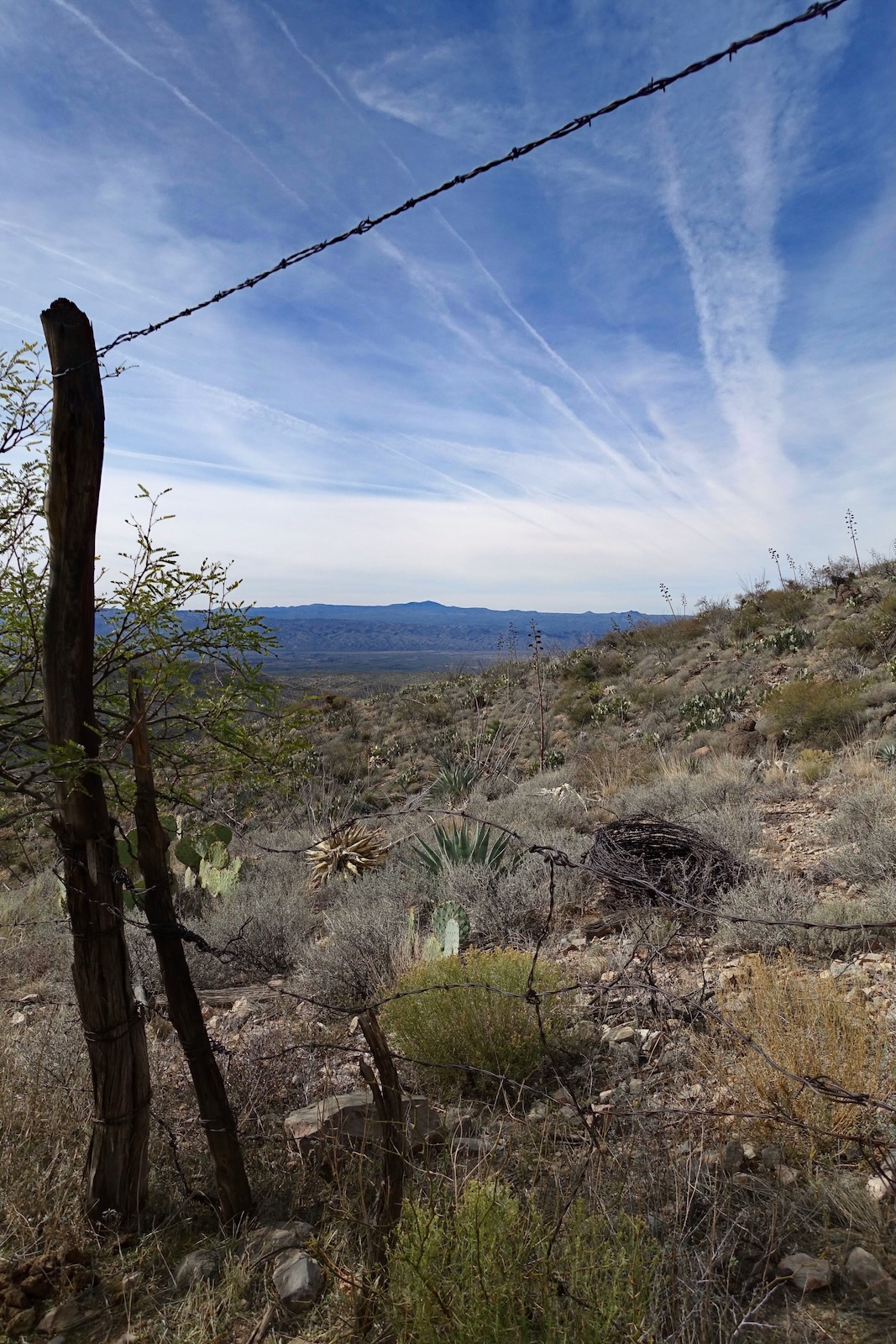
We play all over the lower buttress while moving toward the east. We hopped over a mangled barbed wire fence.
(THW, photo)


We were confronted by an ocotillo challenge. We worked around the upper layer of orange cliffs on the right.

We arrived on the saddle west of Holy Joe Peak at 3.0 miles, 4,620 feet.

Zapata Mountain
The image below was taken in the saddle looking north. Point 4,775' at the northwest end of Zapata Mountain is image-center. The highpoint is off-image on the right. There is a faint social trail heading north out of the saddle. It is imperative that you find it. It is somewhat obscured by brush in spots and gives up 200 feet but it will save you serious side-hill aggravation. It goes all the way to the Zapata saddle.

The mile-long crest of Zapata Mountain is composed of limestone. Large chunks of limestone are on the surface as the trail closes in on the saddle. Holy Joe Peak and Pasture, and Table Mountain are composed of igneous volcanics. The lower cliffband on the buttress we scrambled through was quartzite. The geology is all mixed up. (THW, photo)

This rift in the earth is appropriately at the head of Skeleton Canyon, a tributary of Holy Joe Canyon. (THW, photo)

Arrive in the Zapata-Holy Joe Peak saddle at 3.8 miles, 4,620 feet. (Curiously, this is the same elevation as the saddle west of Holy Joe Peak.) There is a gate and fenceline at the saddle and an abandoned road coming up from the east.

Zapata Mountain has a 200-foot prominence, easily mounted.

Weathered limestone boulders with deep nodules are scattered all over the south ridge. Geologists attribute the characteristic nodules to various origins including fossilized burrowing organisms and mineral aggregates.

Reach the highpoint of Zapata Mountain at 4.0 miles, 4,820 feet. The summit register was placed in 2001 by the Southern Arizona Hiking Club. SAHC visited twice more in 2009 and 2023. There were no other entries. A red-tailed hawk circling overhead was trailed by a "scream" of swifts. The cliffs seen below encompass Table Mountain.

Throughout my hiking life I have successfully found a way around private property. We were caught off guard when we located a very old metal sign tucked among the summit boulders that read: "Private Property, No Trespassing, George Whitt...Wildlife Preserve." Later from home, an extensive search yielded no information. ("George Whitten" is a good guess if you want to give it a try.) (THW, photo)

We had planned to walk out to Point 4,775' but out of respect for private property, turned back.

Pinnacle Ridge in the Santa Teresa Mountains east of Aravaipa Canyon stood out as a dark mass of granitescape.

Holy Joe Pasture
Of course we wanted to climb Holy Joe Peak. But it is technical so we had to settle for Holy Joe Pasture. We were back in the saddle west of the peak at 5.0 miles. Our plan was to hike southeast holding the 4,600 contour all the way to the saddle northeast of the hilltop, shown.

We crossed a shallow ravine at 5.1 miles. It was slow going given the boulders, cactus, and brush. We headed Mud Spring Canyon at 5.4 miles. We were able to cross an intact fenceline at a makeshift wire gate at 4,640 feet. Bundles of rusted coiled wire were vestiges of the Old West.

We were in the saddle at 5.6 miles, 4,660 feet. Below, the unscalable barrier wall of Table Mountain carries on.
(THW, photo)

Holy Joe Pasture has a rise of just 142 feet from the saddle. The brush was fierce to begin but it opened up as we gained elevation.

We topped out on the crest at 5.8 miles. While the little hill falls well short of a ranked summit, it felt like a real mountain. The top is a jumble of stacked blocks cracked and separated by freeze-thaw. Views are good; it's quintessential West. SAHC placed the summit register in 2005. The mountain is smack in the middle of a block of Arizona State Trust Land. (THW, photo)

Little Table Mountain to the southeast was a welcome sight. I've looked at it from several much higher peaks in the Galiuros.

Standing on the summit we were transfixed by a sun halo. The relatively rare ring of light forms around the sun as light refracts off ice crystals present in thin, wispy, high altitude cirrus clouds. The prism effect of light passing through six-sided ice crystals separates the light into various
color frequencies. It makes the halo look like a very pale rainbow with
red on the inside and blue on the outside. (THW, photo)

There is no best way off the mountain. From the summit, you can see the entire road system you hiked in on.

No matter how you descend there will be short cliff bands. We tackled or diverted course one after another. The wall seen below armors the summit. We found a break close to the crest. Scrambling should not exceed Class 2+.

We started out on the west ridge.

The forementioned 400-foot escarpment must be bypassed on its north. We did endless recalibrating to work around walls and to avoid excessively steep pitches. Thorny brush was the biggest impediment. Be ever mindful of catclaw. One reached out and gathered me up in its deadly embrace. When I tried to extract myself I just got more unsnarled. My brave partner disentangled me.

This image looks back at the significant escarpment we skirted.

At 3,840 feet we took our chances and dropped into Mud Spring Canyon. Generally, Sonoran drainages are choked and to be avoided but this one was a gift. It carries enough water periodically to scour it clean. We descended on water smoothed pink bedrock. Tanks held clear water. Bliss out! (THW, photo)

We reached the confluence with Holy Joe Wash at 6.8 miles, just upstream from where the road crosses the wash. We retraced steps from there. Save energy for the heft back up to 4,000 feet and subsequent undulations in the track. Looking back, Holy Joe Pasture is hard to distinguish from Table Mountain. Its blocky summit was the highlight of the hike.

No comments:
Post a Comment