Essence: Peak 12,634' is midway between Sunshine Mountain and Lizard Head on a northeast to southwest running divide between Wilson Meadows and Bilk Basin. LiDAR has elevated the ranked summit to 12,641' with a rise of 339 feet. The view of Lizard Head throughout the hike is sensational. From the summit look immediately west for mesmerizing views of Mount Wilson, Gladstone Peak, and Wilson Peak. There are other possible approaches; the one described here is the most direct. The hike begins from CO 145 near Trout Lake and takes a locals' shortcut trail west to the Lizard Head Trail. From Wilson Meadows, the demanding route is off-trail and navigation is challenging. Ascend through a forest cluttered with deadfall. Pitch up a very steep incline for 800 feet to the divide. This marvelous mountain is overshadowed by its legendary neighbor and consequently, is seldom visited. The hike is in the 41,486 acre Lizard Head Wilderness managed by the Uncompahgre National Forest.
Travel: The shortcut trail is on the north side of Lizard Head Pass near the Trout Lake turnoff, 0.05 mile north of mile marker 61. There are several pullouts in the vicinity. The small parking areas are on a high speed turn so be very cautious pulling off and onto the highway.
Distance and Elevation Gain: 9.8 miles; 3,700 feet
Total Time: 6:00 to 8:00
Difficulty: Trail, off-trail; navigation challenging; Class 2+ with mild exposure on the summit block
Map: Mount Wilson, Colorado 7.5' USGS Quad
Date Hiked: July 31, 2024
Quote: The flower grows without mistakes. A man must grow himself, until he understands the intelligence of the flower. Deborah Love Matthiessen
The approach to Peak 12,634' is rather arduous but the summit ridge is playful and the scenery is without parallel. The Lizard Head monolith, a 400 foot-tall volcanic remnant visible across vast distances, is less than a mile south.

Route: From CO 145, hike west on the "Shortcut," Lizard Head, and Wilson Meadows trails to Wilson Meadows. Off-trail, cross the bottomland and ascend west through deep timber into the alpine. Mount steeply to the Sunshine Mountain--Lizard Head divide. Climb north to the summit of Peak 12,634'.
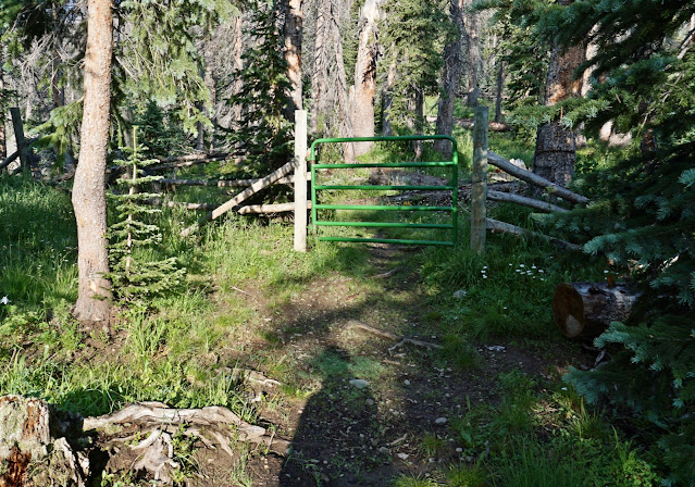
I think of the Shortcut Trail as the local's sneak route to the Lizard Head Trail. The start of the trail on the west side of CO 145 is correctly shown on the Mount Wilson quad. However, the footpath has been rerouted. Map Builder on Cal Topo shows the reroute correctly. Look until you find the trailhead, 70 yards north of mile marker 61. The start of the unsigned trail at 9,880 feet is subtle.

The path ascends north onto an open slope. It gets a little wonky for a few yards. Search it out.

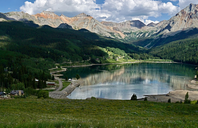
In afternoon light, Trout Lake reflects the audacious high peaks framing the west wall of the Ice Lake Basin: Pilot Knob, Golden Horn, Vermilion Peak, and Fuller Peak. Vermilion Peak, 13,909' (LiDAR), is a Colorado Centennial ranked number 72. (Thomas Holt Ward, photo)
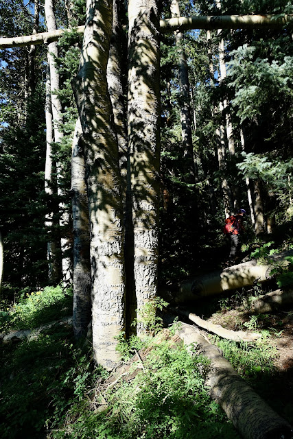
At 0.2 mile the trail hooks west and enters a deep and dark mixed forest of old aspen, Engelmann spruce, and Douglas fir. The trail is clear, direct, and steep.
At 0.5 mile, 10,360 feet, intersect the Lizard Head Trail and turn right. In 2024, there were three logs laid across the junction to keep hikers on the Lizard Head Trail. Make a mental note so you don't blow by the turnoff on your return.

Initiate a series of switchbacks mitigating the grade on the constructed trail. Igneous blocks are piled up on either side. The floral array indicated that summer, so fleeting, was winding down already. Tell-tale goldeneye (shown) was thriving with mid-summer bloomers--solidago, rayless senecio, yarrow, harebell, mountain gold, burnt orange agoseris, and withering corn husk lily.

As you close in on the saddle northeast of Black Face, the trail wanders through a talus runout. If there was any doubt of the changing season, growing among the stones was native honeysuckle with midnight purple berries and baneberry with brilliant red fruit clusters. In the saddle at 1.2 miles, 10,900 feet, the Lizard Head Trail turns south, climbs over Black Face and proceeds toward Lizard Head. Our route turns right at the "Y" following the sign for Wilson Meadows.

We had been on this trail more than once on our way to San Bernardo Mountain so it was highly familiar, including the squeeze through an outrageous display of orange sneezeweed. The central cone is covered in golden pollen that attracts butterflies. (THW, photo)

The Wilson Meadows Trail differs from what's indicated on the Mount Wilson quad. Go with it. The reroute is trodden and maintained. At 1.7 miles, bear slightly left at a signed split. (In 2024, the wooden sign had fallen off the post.) At this junction, the divide with Lizard Head, Peak 12,634' (image-center), and Sunshine Mountain is seen for the first time. Our route goes through the forest and straight up the wall, contacting the divide at the Lizard Head saddle. (THW, photo)

The Wilson Meadows Trail runs down two ridges composed of Mancos Shale. As you get toward the bottom of the first ridge watch for a cairn guiding to the right. You'll see the trail diverting into the woods.

At 10,900 feet, we passed through a wet glade with star gentian. My partner is partial to this plant and he'd been on the lookout all summer. And here they were, so abundant the meadow had a deep purple cast. (THW, photo)

The stars appear to have a synergistic relationship with fringed grass of Parnassus. We hadn't seen these flowering for years and yet in this isolated meadow the two species were intertwined. I am stunned by the notion that our Earth goes about creating beauty in places so remote, few humans, if any, take notice. (THW, photo)

As we approached Wilson Meadows we ran into a group of young teens and staff from the Telluride Academy. They were camped out at the meadows and were on a day hike to the summit of San Bernardo Mountain. I was impressed with their excitement on the way up the mountain and their pride as they returned to camp. Now that's "Wild Learning."

The trail segment of the hike ends at mile-long Wilson Meadows, a fusion of iridescent green colors stemming from a diverse array of dense grasses, sedges, rushes, and forbs. It hadn't been raining so we didn't get our feet wet but I've heard the crossing can be a boot-soaking enterprise. The meadow bottomed out at 10,540 feet and we jumped across the rill at 2.7 miles. We'd given up 360 feet from the Black Face saddle that we'll have to reclaim on our return. Looking at the image below, Peak 12,634' is left of center on the horizon. Where you enter the timber is not critical but our optimal location was just left of image-center.

If there is a crux on this hike, it is the 800-foot ascent through the woods riddled with fallen timber. We happened on elk trails, a significant assist in avoiding the worst deadfall tangles. The pitch undulates. It's impossible to see anything but trees, so use dead reckoning to keep pointed west.

We came alongside a running stream at about 11,000 feet. We stayed on the south side of the drainage shown on the topo. By 11,100 feet, the deadfall abated and there were periodic glades.

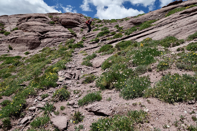
We broke out into the alpine at about 11,340 feet and got a visual of the next challenge, an 800-foot highly pitched incline to the divide. We paused and reconnoitered. Our plan was to stick to the green and scoot around the bands of Telluride Conglomerate. But, as it turned out, the rock wasn't a hindrance.

If anyone had been climbing Lizard Head, Colorado's most dangerous (and technical) thirteener, we would have seen them.

The slope pitches radically at 11,500 feet. Humping up the incline took a lot of physical strength and mental discipline. The footing was good on plant platforms and eventually we discovered braided game and use trails zigzagging up the pitch. I was amused that on our return we kept stepping on our own footprints. It is a big wide arena and yet going downhill, we were pretty much on our upcoming route. Landscape magic happens time and again hiking off-trail.

As we closed in on the divide, we barged right up the rock.
We arrived on the Lizard Head--Peak 12,634' saddle at 4.6 miles, 12,300 feet. There was a heart-stopping view of the fourteeners in the San Miguel Mountains. Looking north, the ridge is a hiker's dream--softly rounded with pretty pink stone glazed with exfoliated pebbles. (THW, photo)

Looking at the topo, it looks like a simple traverse south to Lizard Head but I expect it is a trick of 40-foot contour lines. Please leave a comment if you are familiar with this passage. (THW, photo)

Walking north up the ridge was mellow and pleasant, but we weren't at all sure how we were going to deal with the 40-foot sheer wall standing between us and the summit.

From afar, it looked like we could pass through the notch on the right but a vertical cliff blocked passage to the ledge.
We decided to go around the base of the block on the east side staying as high as we could. The sidehill traverse was steep but the talus was stable given careful foot placement.

As soon as we rounded the corner we pitched directly up to the ridge. Consider that you are stepping on alluvium deposited in debris flows predating the most recent volcanism.

The footing was slick on loose rubble but it was serviceable. I did a couple of five-point butt slides on the way down.

Past the big block, everything is a breeze, including the cap of volcanic rock on the summit.

Mount the small but comfortable crest at 4.9 miles.

The peak register was located in the summit cairn. We were the fifth party in three years to sign. This mountain enjoys few visitors. Yes, it is a long approach, the woods are cluttered, the wall is a chore. But the summit experience is beyond words.

We climbed Sunshine Mountain with a group of friends in 2015 after admiring it for years while driving on CO 145.

This image shot from Sunshine would imply that the ridge between the two peaks is impassible for hikers. Peak 12,634' is visible right of image-center below the horizon.

The view west across Bilk Basin is so outrageous, it's a mind ripper. From the left are Mount Wilson, Gladstone Peak, and Wilson Peak.

Looking east, in the foreground is San Bernardo Mountain. If you enjoy Telluride Conglomerate, this is a peak for you. It pairs nicely with Black Face. To the east things get complicated but if you can find the Ophir Pass Road doing its rising traverse to the pass it will help you get oriented. In the center of this image is fearsome South Lookout Peak and Ulysses S. Grant Peak.

Fringed gentian cheerfully blossom as our favorite early-season flowers are going to seed. There is always a tinge of sadness when the gentian appear for they signify summer is drawing to a close. (THW, photo)

Possible Alternative Routes
We are grateful to John Bregar for navigating the most efficient route to the peak from the east. There may be a good approach from Black Face via the Lizard Head Trail, or even the Cross Mountain Trail. These approaches would be longer and entail more climbing, but the snarled forest would be avoided.
As we were descending from the divide we saw a trail heading up to the east ridge of Lizard Head, shown. We are unsure whether you can connect with the Lizard Head Trail but it'd be worth exploring the possibility.